Showing posts with label tropical cyclone. Show all posts

Bay of Bengal Storm (MAARUTHA) To Hit Myanmar April 17-18, 2017

APRIL 13, 2017, THURSDAY 

The expected deep depression/tropical cyclone MAARUTHA in the Bay of Bengal will be spawned as a low pressure area today a few hundred kilometres east of the Sri Lankan coast. Forecast models say it will go on ultimately and hit the coast of Myanmar at Sandoway on April 17-18, 2017.

This system will intensify rapidly after forming today evening, Indian Standard Time, IST. It will move rapidly in a north northeasterly direction, strengthening all the time. It will move past Andaman Islands in the next 48-72 hours. By Saturday it will turn into full blown tropical storm.

It remains to be seen if the IMD (Indian Meteorological Department) deems it fit to be a tropical cyclone MAARUTHA or labels it just a deep depression. Our estimate is that the system will be throwing out sustained winds of 65-75 km/h by April 16. A tropical cyclone.

The storm will weaken into a depression before landfall into the Rakhine state of Myanmar near Sandoway on April 18, 2017. It will bring heavy rains to Andaman and Nicobar islands and Myanmar in the coming days. Our estimate is at least 8-10 inches of torrential precipitation.

American GFS model predicts a stronger storm. It envisages the system moving more quickly and hitting Myanmar south of Sittwe on April 16. Thus leaving even less time for authorities in Myanmar to prepare for this imminent quick moving threat. The country's disaster relief personnel should swing into action at the earliest to take preemptive measures to mitigate the losses.

Our advice to tourists in the Andaman and Nicobar islands is to go to nearby storm shelters or leave for the mainland earliest possible. The weather is going to be very nasty in the coming days.

Probable position of Bay of Bengal storm on April 16, 2017.
Disturbed conditions in Bay of Bengal presently. The yellow and red dots denote lightning. The dark blue color shows heavy precipitation.
Total accumulated rainfall till April 22, 2017
Share this PostPin ThisShare on TumblrShare on Google PlusEmail This

Bay of Bengal Depression/Tropical Cyclone Is Being Born

APRIL 12, 2017

A low pressure area is being gradually formed in the Bay of Bengal. A look at the latest satellite image of the sea reveals massive clusters of disturbed weather and powerful thunderstorms. From this morass of clouds will emerge a rain system between Nicobar islands and the Indian mainland.

Global forecast models are divided over whether this low will intensify into a deep depression or tropical cyclone MAARUTHA. The American GFS is clear in portending a cyclone. It predicts a tropical storm nudging along the Myanmar coast bringing a deluge to these areas.

Other models expect a deep depression or a weak tropical storm to form in the next 48-72 hours. The system will move north northeasterly and head for the border of northern coastal Myanmar and Chittagong region of Bangladesh. 

Whatever happens, Indian Andaman and Nicobar islands are in for a deluge in the coming days. Upto a metre of rainfall may occur. Tourists visiting these islands are advised to head to safer areas or leave for mainland India as soon as possible as the weather in the Bay of Bengal is going to be very disturbed in the next coming 5-7 days.

Disappointingly for drought hit Tamil Nadu the present expected storm system will not give it the much needed rain, though Sri Lanka will experience heavy showers under its influence.

Rains will come to Tamil Nadu by the end of this month, but it will be owing to another system.

The pink denotes areas of very heavy rainfall presently.


Share this PostPin ThisShare on TumblrShare on Google PlusEmail This

Sea Off North Western Australia To Spawn Many Storms In April 2017

APRIL 2, 2017

After the dangerous typhoon Debbie, the seas off the Australian coast is going to see hectic storm activity. And all of it will occur in the Timor Sea and adjoining Indian Ocean off the coast of Northern Territory and Western Australia.

Almost all forecast models are predicting 2 or 3 depressions or tropical storms in that area of the ocean. This will happen in the coming days around April 10. Two of the storms may sail harmlessly west into the Indian Ocean without landfall into the country-continent.

But the third one that will form off East Timor is the one to watch out for. The American GFS model expects it to intensify into a 955 hPa monster and hit the coast of Western Australia between Broome and Port Hedland on April 11-12, 2017.

The expected storms will be named Cempaka or Ernie depending on where the cyclone forms, in the waters of Indonesian Met jurisdiction or in BOM (Australian Bureau of Meteorology) waters.

Latest forecasts hint at the possibility of the formation of two tropical storms. The first will start off as a low pressure area on April 5 south of Java. The second low pressure system will form around April 9 in Timor sea north of Darwin.

The American CPC (Climate Prediction Center) in it's latest report says, "GEFS indicates that the Timor Sea region to the north of Australia has an elevated risk of tropical cyclone development".


Share this PostPin ThisShare on TumblrShare on Google PlusEmail This

VARDAH Effect: Chennai, Parts of AP, Tamil Nadu Stare At Floods Dec 12-13

DECEMBER 10, 2016, SATURDAY UPDATE

Our December 9 forecast regarding the track and intensity remains unchanged. Only Tamil Nadu is unlikely to benefit rain wise from this storm. Southern Andhra, parts of Rayalseema and Karnataka will receive most rainfall on December 12-13.

Nellore, Anantpur, Cuddapah and Chittoor districts in Andhra Pradesh. Chitradurga, Tumkur, Bangalore (N & S) districts in Karnataka.


DECEMBER 9, 2016, FRIDAY 

Latest forecasts by reliable forecast models say that owing to Bay of Bengal tropical cyclone VARDAH, southern parts of coastal Andhra Pradesh, northern coastal Tamil Nadu, including Chennai may face flooding rains beginning December 12, 2016.

VARDAH is strengthening and moving away from the Andaman Nicobar islands. It is heading now in a west-north-westerly direction. Going by that one may think central Andhra coast will be the target of this storm. Both the American GFS model and US Navy's JTWC think so too.

But come December 11 and the cyclone will dip southward and make landfall bang on the Andhra-Tamil Nadu border coast on late evening of December 12. Hence the chance of a Chennai deluge. We think the storm will bring more rains to Tamil Nadu than to Rayalseema because of the last moment "dip".

At present it a 986 hPa storm. Sustained winds well over 100 km/h. But it will weaken before landfall. 

The districts in Tamil Nadu which may be most affected are Tiruvallur, Kanchipuram and Vellore. The Andhra districts of Nellore, Cuddapah and Chittoor will be worst hit.

Share this PostPin ThisShare on TumblrShare on Google PlusEmail This

Category 3 Typhoon LIONROCK May Hit Tokyo, Central Japan August 30, 2016

Typhoon LIONROCK west Pacific Ocean Japan August 2016

AUGUST 25, 2016, THURSDAY 

Intensifying typhoon LIONROCK is hovering in north west Pacific Ocean presently just a few hundred kilometres from Okinawa. 

Unlike most west Pacific Ocean tropical cyclones this one did not emerge from lower latitudes in the sea east of Philippines but came from North Pacific.

Forecast models seem divided as to where the storm will go. 

In the next couple of days it will retract its steps and strengthen further. Our estimate is by Saturday-Sunday it will be a category 4 hurricane with sustained winds of 240 km/h.

It will then weaken a little and slam into central Japan near Tokyo on Tuesday, August 30, 2016 with winds in excess of 200 km/h.

Worrisome for people of Japan.

0000 hours GMT, August 25, 2016

POSITION: About 900 kilometres roughly east of Taipei 

WIND SPEED:  Sustained- 200 km/h, Gusts- 240 km/h
Share this PostPin ThisShare on TumblrShare on Google PlusEmail This

Super Typhoon LIONROCK May Hit Japan On August 29, 2016

AUGUST 23, 2016, TUESDAY

Tropical storm LIONROCK has already formed. At present it lies about 650 kilometres northeast of Naha, Okinawa in Northwest Pacific Ocean. It already has sustained winds of over 100 km/h. In the coming days it will move a little in the direction of Taiwan then abruptly backtrack.

By Friday it will intensified into a powerful storm. Forecast models indicate the by Sunday it will have a central minimum pressure of an astounding 915 hPa. According to research by American meteorologists with such low pressure in its eye, the tropical cyclone will be throwing winds of about 130-140 knots. That is a category 5 hurricane.

The worrisome aspect is reliable numerical forecast models say super typhoon LIONROCK may hit either southern or central Japan on August 29, 2016. If this does happen it may cause considerable destruction in the country.

The little blessing is the storm is expected to weaken before landfall into Japan.

Tropical storm LIONROCK west Pacific Ocean August 2016
Share this PostPin ThisShare on TumblrShare on Google PlusEmail This

Tropical Storm DIAMMU Brewing In South China Sea

AUGUST 17, 2016, WEDNESDAY

Tropical storm DIAMMU is imminent in the South China Sea south of Hong Kong-Macau coast of Guangdong province coast of China.

It is a low pressure area presently. NOAA calls it Invest 95W.

By tomorrow it will have intensified into a tropical cyclone.

It will move west through Haikou, Hainan island on Thursday and enter the Gulf of Tonkin.

It will make landfall into northern Vietnam on Friday, August 19, 2016, with winds of 80-100 km/h. But latest forecast says it might be 140-150 km/h winds as the typhoon is expected to intensify rapidly before hitting Vietnam. A central minimum pressure of 970 hPa. Powerful storm.

It will weaken into a persistent low pressure area as it moves through Vietnam, Laos, Myanmar. It will reach Indian Northeast and Bangladesh on August 21-22.

Tropical storm DIAMMU August 2016 South China Sea


Share this PostPin ThisShare on TumblrShare on Google PlusEmail This

Two Storms In West Pacific Soon? CHANTHU, DIAMMU Coming?

AUGUST 10, 2016


Forecast models are giving confusing signals of the possibility of two or three tropical cyclones to form in the west Pacific, South China Sea area in the coming days. Alarming times for Philippines, Vietnam, China, Japan, Korea, Taiwan.

We had predicted the possibility of typhoon CHANTHU forming in the coming days in the South China Sea and causing a hazard to China.

Well it seems, two tropical cyclones are likely in the region, not one. First CHANTHU, then DIAMMU.

Tropical storm CHANTHU may form first in the Gulf of Tonkin soon. It is likely to intensify rapidly and hit the Haiphong coast of Vietnam on August 15.

Tropical cyclone DIAMMU will form on August 15 in the South China Sea off the Philippines coast. It is expected to turn into a typhoon and hit the coast of Guangdong, China in the Hong Kong-Macau belt around August 18, 2016.

The situation is nebulous at present. Different forecast models are saying different things. For instance, the GFS forecast model predicts a powerful typhoon affecting Philippines, Taiwan around August 20.

Things will become clearer in the coming days.

UPDATE: AUGUST 11, 2016

Something is going to come up soon in the Gulf of Tonkin off the Vietnam coast. A low pressure area is likely to be spawned on August 14, which in a few days might intensify into a tropical cyclone by August 18-19.

There is also a possibility of a strong typhoon hitting Taiwan on August 20, 2016. This may form many hundreds of kilometres north of Guam on August 16.
Share this PostPin ThisShare on TumblrShare on Google PlusEmail This

May 2016: Extreme Weather Forecast And Possibilities, Updates

WET MONTH FOR OMAN AHEAD?
May 5, 2016

Oman and perhaps the UAE are in for a stormy wet month if forecast models are to be believed. By the last week of May, a low pressure/depression is likely to move into central Oman bringing heavy rains. 

Then by June 10, 2016 a powerful tropical cyclone may hit northern Oman. This storm is likely to form around June 5, 2016 near the Kerala-Karnataka coast of India.

These predictions are based on the CFS (Climate Forecast System) model created by the US agency CPC (Climate Prediction Center) and thus are nothing to sneeze at.

Though one cannot say 100% that a cyclone will hit Oman, since the CFS forecast has been persistently foretelling a storm since the last 10 days, there is a good possibility of a tropical cyclone in early June developing in the Arabian Sea. Where it goes remains to be seen.


US AGENCY CPC SAYS NO CYCLONE TILL MAY 17
May 4, 2016

The CPC, the US agency says in it's latest forecast that though there will be increased rainfall in southern Arabian Sea, a cyclone is unlikely till May 17.

Please note that the CFS model has been developed by the CPC.

It says....

"During Week-2, the CFS and ECMWF models agree that above-median rainfall will continue across the Horn of Africa and western Indian Ocean. Above-median rainfall forecast across far southern India, Sri Lanka, and parts of the central Indian Ocean is related to the potential for a developing MJO by mid-May. 

Tropical cyclone development is unlikely across the global tropics during the next two weeks. This inactive period for tropical cyclone genesis is typical for early May."


STORMS BREWING IN ARABIAN SEA IN END MAY
May 4, 2016

Latest CFS weekly forecasts indicate intense thunderstorm activity in the Arabian Sea off the coast of Oman after May 15, 2016. It is to be seen if it throws out a cyclone.


MONSOON WILL PUSH IN AROUND MAY 15
May 4, 2016

Below is the GFS forecast for May 15, 2016. It shows the high altitude 150 hPa winds. The easterly jet stream has been pushed up and the monsoon winds are arriving in the Andamans and Nicobar Islands.


TROPICAL CYCLONE UNLIKELY TILL MAY 22
May 4, 2016

The chances of a tropical cyclone developing in either the Arabian Sea or Bay of Bengal till May 22 seems remote. The CFS which had been hinting at a Arabian Sea storm by May end says today in its data that a cyclone is now likely in the Bay of Bengal in mid June. 

This has to be taken with a pinch of salt. Cyclones are inherently unpredictable. And May-June being storm seasons anything can happen anytime.


FORECAST TILL MAY 22
MAY 3, 2016

This is from IITM (Indian Institute of Tropical Meteorology, Pune)

The next 20 days forecast indicates that
Subsequent to the likely rain spell over major parts of India during the first pentad,  heat wave conditions are likely to re-develop over parts of east & central India (viz., Gangetic west Bengal, Odisha, Vidarbha and Telangana) during 7th – 11th May.  This is likely to intensify and spread over to cover major parts of central and adjoining peninsular India and northwest India, during the period, 12th – 21st May.

Cyclogenesis is un-likely over the north Indian ocean during 2nd – 21st May.

However, cross equatorial flow in the lower troposphere is likely to reach south bay of Bengal and adjoining Andaman Sea around 15th May.

Likely eastward propagation of  the convective phase of MJO across the Indian ocean may cause a pre-monsoon rainfall peak, with above normal rainfall activity over extreme south peninsula during 12th – 21st May.

Western Disturbances are likely to cause above normal precipitation over western Himalayan region during 2nd – 6th May and 12th – 16th May.

CYCLONE ROANU IMMINENT AT MONTHS END?
May 2

Is a tropical cyclone brewing in the Arabian Sea?
Yes, if the Climate Forecast System, run by an US agency is to believed. 
The CFS though a climate forecast model gives daily updates. And it's data has been suggesting a cyclone forming near the Kerala coast around May 23, 2016 for the last few days.
The tropical cyclone ROANU will be a massive one and it will traverse northward in the Arabian Sea for a week.
At one time it seems it will hit Oman but it will swerve and hit Pakistan on June 1, 2016.
At present it is a mere possibility.
Support from weather models like the GFS and ECMWF is awaited.
Though the GFS in today's forecast data says a low pressure is likely to develop near the Indian Kerala coast on May 18.

Cyclone ROANU Arabian Sea
Share this PostPin ThisShare on TumblrShare on Google PlusEmail This

Cyclone FANTALA April 2016: Latest Updates


FINAL UPDATE:APRIL 21, 2016

Within 24 hours the weakening tropical cyclone will again move course roughly westward and pass the northern tip of Madagascar on April 24/25. There is little chance of it threatening Mauritius in any way.
The infrared image of the storm was taken at 0200 hours GMT today.


UPDATE: APRIL 20, 2016

Cyclone Fantala is steadily weakening and will continue to do so. It is now moving ESE. After a few days it will drift back in a WNW direction, passing the northern tip of Madagascar on April 25. It may then fizzle out mid sea or bring rainfall to the Tanzania-Mozambique border coast later. The only land area it may affect is Saint Brandon, the little isle north of Mauritius.

Interestingly forecast models are hinting at a new tropical storm in the southern Indian Ocean around April 25. This possibility is supported by NOAA in its fortnightly outlook (See map below)


UPDATE: APRIL 19, 2016

After becoming the strongest tropical cyclone recorded in the Indian Ocean (North and Southern) on April 18 with one minute sustained winds of 275 km/h, FANTALA is now weakening and moving in a southeasterly direction.

It will move so till April 23 after which it will again change direction and move west. It will hit the northern tip of Madagascar on April 25/26 as a tropical storm.

Going by present forecasts, the threat to Mauritius and Rodrigues seems to be receding.

Satellite image cyclone Fantala April 19 0330 GMT
Fantala is weakening as the latest satellite image ( April 19, 0300 hours GMT) shows

Latest track forecast cyclone Fantala April 19
Latest track forecast for Fantala


UPDATE: APRIL 17, 2016

Fantala is presently a furious storm, with 240 km/h winds according to the Joint Typhoon Warning Center. It lies about 1100 kilometres NW of Mauritius.

Reliable forecast models now agree that within 24-48 hours the cyclone will swing southeasterly. It may pass between Mauritius and Rodrigues on April 23, 2016. A direct hit on Rodrigues is not ruled out.

The cyclone is expected to weaken considerably in the coming days after April 19.

Tropical cyclone Fantala satellite image 0730 GMT April 17
Satellite image 0730 hours GMT, April 17, 2016

----

UPDATE APRIL 16, 2016. 

Even reliable forecast models are giving erratic predictions at every update. There is a possibility that cyclone Fantala might hover around about 500 kilometres NW of Mauritius for a week then weaken and make landfall into northeastern Madagascar.

But we still believe that the storm will swing southeasterly on April 19 and hit Rodrigues island on 22-23rd.

Meanwhile Fantala has intensified into a category 4 hurricane with winds that the JTWC expects to touch a whopping 130 knots (240 km/h). It presently lies about 800 kilometres north of Mauritius.

TRACK FORECAST ISSUED TODAY 

----

UPDATE APRIL 15, 2016 - There is little change in the forecast scenario since yesterday. Fantala will continue west till April 18 as a category 3 hurricane and then swing down and move southeasterly henceforth. A direct hit on Rodrigues is possible on April 22, 2016. But by then the cyclone will have weakened considerably to a category 1 or maybe just a tropical storm.


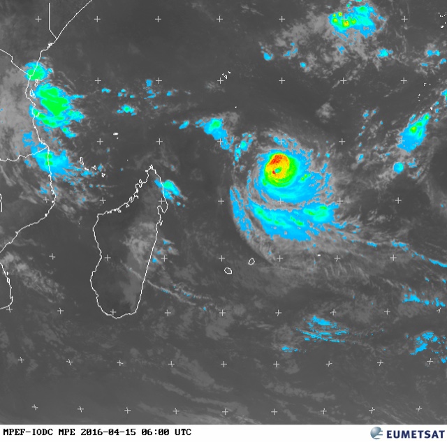
MPE IMAGE OF CYCLONE FANTALA APRIL 15, 2016. 0600 HOURS GMT 

----

UPDATE APRIL 14, 2016 - Fantala is well on its way in turning into a category 4 monster hurricane soon as it moves west. Track forecasts indicate a abrupt change in direction on April 17-18. It will weaken slightly and move southeasterly. It is to be seen if it moves betwixt Mauritius and Rodrigues or hits Rodrigues directly. This will happen on April 21.


Cyclone Fantala infrared image April 14 southern Indian ocean
INFRARED IMAGE APRIL 14, 2016 TROPICAL CYCLONE FANTALA 0200 GMT 

----
Update April 13, 2016 - All forecast models agree on Fantala's future for the next 4 days. It will move westerly in the Southern Indian Ocean, intensifying all the time and reach the northernmost tip of Madagascar. The European model ECMWF, envisages it attaining a central pressure of 945 Mb. A category 5 hurricane.

Then from April 17-18 it will abruptly change direction and move southeasterly and move between Mauritius and Rodrigues Island on April 21. It will have weakened quite a bit by then. This part of the forecast is prone to change. A little shift and a direct hit on either Mauritius or Rodrigues will happen


----

Update: April 12, 2016 - Cyclone Fantala has formed. It lies about 650 kilometres south of Diego Garcia and is moving west. It will continue doing so for the next 3-4 days and then will abruptly change direction and move south or south-easterly. Present forecasts say it will hit Rodrigues Island on April 20 but Mauritius cannot be deemed safe as the forecast track has been changing all the time.

Satellite image cyclone Fantala April 12, 2016

----
Update: April 11, 2016 - The cyclone is presently a low pressure area south of Diego Garcia. It is strengthening all the time. Our guess is it will become a tropical cyclone by April 14. As to its track, the picture is nebulous. But forecast models at present are predicting that it will pass by Mauritius/Rodrigues Island around April 20.
----
We have already warned on our Twitter page about a possible tropical cyclone brewing in the southern Indian Ocean in the coming days. We had also said the cyclone Fantala was unlikely to affect Mauritius, La Reunion islands.

But recent forecasts by reliable computer forecast models hint at the possibility of Fantala turning into a massive 946 Mb storm which will hover near the northeastern coast of Madagascar by April 17, 2016.

History says any tropical cyclone in that area tends to move south or southeasterly. Hence the possibility of Fantala hitting Mauritius or La Reunion is quite strong. The GFS model envisages a massive monster hitting the isle nation.

It is also possible that the storm may move through the northern tip of Madagascar and crash into Mozambique or southern coastal Tanzania. The ECMWF model supports this scenario.

The forecast image shows the cyclone's position on April 17.

Cyclone Fantala Southern Indian Ocean Mauritius
Latest satellite images of cyclone Fantala 
Share this PostPin ThisShare on TumblrShare on Google PlusEmail This

Cyclones CHAPALA MEGH Imminent In Arabian Sea, Bay of Bengal Soon?

By XWF, October 22, 2015

Global forecast models are hinting at the possibility of the North Indian Ocean spawning 2 tropical storms in the coming days this October-November 2015.

It is not certain at this stage whether the expected systems will be depressions or tropical cyclones.

The Arabian Sea storm will arise first around October 26-27. Opinions differ as to what track path it will take. One scenario is it will hit northern Yemen around November 2. Another scenario is it makes landfall into central Oman and moves north right through the country.

The Bay of Bengal cyclone (Chapala or Megh?) will come later. It will form by October end near the northern Tamil Nadu coast and then barrel through the sea in a northeasterly direction in early November. Where it may make landfall is hard to say at this stage. Andhra, Odisha, West Bengal, Bangladesh or Myanmar?

One thing is certain. The North Indian Ocean is in ferment and may throw out storm systems soon.

Arabian Sea cyclone CHAPALA heads to Oman on November 2, 2015

This latest satellite image shows the mass of thunderstorms which may give birth to cyclone CHAPALA 

Share this PostPin ThisShare on TumblrShare on Google PlusEmail This

Tropical Cyclone Chances In North Indian Ocean (Arabian Sea, Bay of Bengal) Uncertain

The chance of a tropical cyclone developing in the North Indian Ocean has receded according to latest forecasts from various models.


A cyclone or not? In the North Indian Ocean. That is the question now.

In the last few days the GFS Model had been gung-ho  about the prospect of an Arabian Sea cyclone. The Canadian CMC had supported while the European Model (ECMWF) had disagreed going so far as to say that the storm would form in the Bay of Bengal.

Come today and all the forecast models are showing flat storm less  forecasts for the North Indian Ocean. The GFS says no cyclone. The CMC says no cyclone. The ECMWF says no cyclone.

What has happened? Has the ocean turned docile? Some meteorologists say the over-active Pacific Ocean is hurling one typhoon after another (Noul, then Dolphin) and sucking off the moisture from the Indian Ocean. Going by this reasoning will the North Indian Ocean become active storm-wise after the demise of super typhoon Dolphin in a week's time? Time will tell.

In the mean time we will closely monitor the Indian Ocean and keep you updated on any incipient tropical cyclone.

Now is the time. Now is the season. Hope the Indian Ocean does not disappoint.

SATELLITE IMAGE NORTH INDIAN OCEAN MAY 2015
WATER VAPOR SATELLITE IMAGE OF THE NORTH INDIAN OCEAN AT 0300 HRS GMT TODAY. WILL IT SPAWN A STORM?

Share this PostPin ThisShare on TumblrShare on Google PlusEmail This

Massive Tropical Cyclone (Ashobaa) To Hit Gujarat May 21, 2015?

LATEST UPDATE MAY 16, 2015

There is no possibility of a tropical cyclone developing in either the Arabian Sea or Bay of Bengal in the coming next few days. Please read our latest forecasts and do not go by earlier articles.
+++++++++++++++++++++++++++


 It is possible that a powerful cyclone (Ashobaa) may soon form in the Arabian Sea in North Indian Ocean, which will intensify and make landfall into Gujarat state of Western India on May 21, 2015.

At presently only the reliable American GFS forecast system predicts this storm but we have seen from experience that generally GFS forecasts are accurate. We shall closely monitor the situation and keep you updated with latest forecasts as soon as we come across them.

According to the GFS, the cyclone will start off as a low pressure area on May 17, near the Karnataka-Kerala coast and then move north and intensify into a tropical cyclone (Ashobaa). The storm is likely to hit Gujarat on May 21, 2015.

We will monitor future GFS forecasts and see if the cyclone formation is sustained. We shall also observe the European Forecast Model and see whether it supports the GFS prediction.

The situation being fluid, we have to wait and see if the cyclone forms and what its track turns out to be. Gujarat, Pakistan or Oman?

Keep in touch for latest updates.

tropical cyclone ashobaa arabian sea gujarat may 2015
FORECAST MA SHOWING ARABIAN SEA CYCLONE ASHOBAA HITTING GUJARAT ON MAY 21, 2015

Share this PostPin ThisShare on TumblrShare on Google PlusEmail This

CFS (Climate Forecast System) Predicts An Arabian Sea Cyclone in June 2015

CFS (Climate Forecast System) has been developed to give long range forecasts for two months and more by the US NOAA.

Perusing the forecast data by the CFS Model one sees a powerful cyclone developing in southern Arabian Sea in the first week of June 2015. The cyclone is expected to move towards the coast of Oman and move along it some few hundred kilometers away

By June 10, 2015, the cyclone will curve north-eastward and hit the coast of Saurashtra between Porbandar and Dwarka and move north into western Kachch and then into Pakistan's Sindh Province

Let us make one thing very clear. The CFS Model is not very reliable. But it does give useful indications. In fact even the reliable GFS and ECMWF forecasts beyond ten days should be taken with a large pinch of salt.

But the cyclone season in the north Indian Ocean is about to begin. The sea temperatures are already over the cut-off point of 26.5 degrees C. The temperature required to fuel a tropical cyclone.

In 2014, the North Indian Ocean had kick-started by Cyclone Mahasen that had formed in the first half of May and gone on to hit Bangladesh.

We will keep a close watch and give you latest updates on the possibility of a tropical cyclone developing either in the Arabian Sea or the Bay of Bengal this May-June, which is the time storms develop.
Share this PostPin ThisShare on TumblrShare on Google PlusEmail This

POWERFUL CYCLONE TO FORM NORTH OF MAURITIUS APRIL 7

There is every likelihood of a powerful cyclone forming 500 kms NNE of Mauritius on April 7, 2015. The storm will pass between Mauritius and Rodrigues and head south. Though a direct hit is unlikey on Mauritius, conditions will be rough on April 7-9. Keep in touch for further updates.

 In the latest satellite image below is seen another cyclone 93S forming in the SE Indian Ocean. A weak storm, it will dissipate soon. The bigger storm will form north of Mauritius on April 7th.


TWO CYCLONES TO FORM IN SOUTHERN INDIAN OCEAN IN THE COMING WEEK Two tropical cyclones are going to form in the S Indian Ocean in the coming days. Storm 93S will intensify soon into a cyclone and move south-east towards the south-western coastal waters of Australia. A weak storm it will form and weaken in a couple of days. 91S will be the bigger storm. It is presently a low pressure area in the ocean. By April 7 it will drift towards Mascareignes and intensify into a tropical cyclone north-east of Mauritius.

There is some confusion as to who will name Storm 93S. The Australians or the folks at Reunion? If 93S is named by the Australian Met then 91S will become Cyclone Ikola. Otherwise it will be named Joalane.

Track Forecast of Storm 91S (Future IKOLA?) in the SW Indian Ocean The Red Line is GFS Forecast Track Yellow Line is Canadian Model GEM. Blue Line is US Navy's NAVGEM Model Forecast.


Share this PostPin ThisShare on TumblrShare on Google PlusEmail This

Early Storm Prediction: March 23, 2015: Cyclone Possible In Southern Indian Ocean By Month End


See Southern Indian Ocean Storm 91S Live

The powerful Pam has become history. The persistent Cyclone Nathan makes its final landfall into Australia's northern Territory. But in a week there is another tropical storm in the offing.

A cyclone is brewing in the southern Indian Ocean and is likely to form on March 29, 2015 a a few hundred kilometres north-east of Rodrigues Island. Present forecasts say the cyclone will move south-easterly and so poses no threat to Mascareignes. Keep in touch for the latest.
Share this PostPin ThisShare on TumblrShare on Google PlusEmail This

97S Turns Into Tropical Cyclone 8S (Diamondra): 98S To Become One On January 29, 2015

Update: 1430 Hours GMT, January 27, 2015

TROPICAL CYCLONE 8S HAS BEEN OFFICIALLY NAMED CYCLONE DIAMONDRA.: It lies now at 18.39 Degrees South, 78 Degrees East. Sustained winds are 75 kph. It is expected to move in a south-west direction. There is no possibility of it coming in the direction of Mascareignes. Right now it is hundreds of kilometers away and it is going to stay that way. Just for the record, Diamondra is going to be no Bansi, but nothing to sneeze at. In 48 hours it will be throwing out winds in excess of 125 kph.

Cyclone Diamondra. WV satellite image take n at 1330 hours GMT, January 27, 2015
Update: 0330 hours GMT, January 27, 2015


As expected 97S has obliged and turned into tropical cyclone 8S. That is what the JTWC calls it. It should soon be christened DIAMONDRA. Another two days and 98S will also turn into a cyclone. Looking at their forecast paths it seems likely that none of them will affect Mascareignes. Though the European (ECMWF) Model says cyclone 98S' (Eunice) periphery might influence Rodrigues Island.

Cyclone 8S presently lies about 1800 kilometers east of Mauritius. It is expected to intensify in the coming days and move in a south-easterly direction. 

In the next two days 98S too will turn into a tropical cyclone. It will be named Eunice. Presently 98S lies about 700 kilometers north-east of Mauritius. On January 29 it will intensify and move south-easterly. It's outer periphery might affect Rodrigues Island on January 30, 2015.

0000 HRS GMT JANUARY 27, 2015. THIS INFRA-RED SATELLITE IMAGE OF THE SOUTHERN INDIAN OCEAN SHOWS CYCLONE 8S AND ALSO STORM 98S WHICH WILL TURN INTO A CYCLONE ON JANUARY 29-30.

CYCLONE 8S (DIAMONDRA?) TRACK FORECAST BY JTWC ISSUED AT 2100 HRS, JANUARY 26, 2015


Share this PostPin ThisShare on TumblrShare on Google PlusEmail This

1/24/2014 Update: Southern Indian Ocean To Throw Up Cyclones DIAMONDRA And EUNICE Soon

Update 0730 Hours GMT, January 24, 2015

We had already warned a few days ago that the southern Indian Ocean was in ferment and was going to spawn a cyclone or two soon. Latest forecasts say this will happen by the end of the month. Tropical cyclones Diamondra and Eunice are coming soon in this ocean.


Diamondra will be formed first. About 1000 kilometers ENE of Rodrigues Island on January 28, 2014. In a day or two it will intensify and move in a general south-easterly direction. Later it will move south. At its strongest it will have sustained winds of 100+ kph. Central pressure of 980. Its path will be such that it will not affect any inhabited islands. Mauritius, Reunion nor Rodrigues will not be affected by Cyclone Diamondra.

Cyclone Eunice will form next, two days later a few hundred kilometers north of Mauritius. It will start intensify and move eastwards first then in a SE direction. On February its periphery will lash Rodrigues Island. Eunice at its zenith will throw out winds of 120+ kph. Mauritius or Reunion are not expected to be affected. But it is too early to say that with any certainty. Please keep reading our updates.

These two cyclones will be spawned from the present three low pressure areas that are bobbing around in the south Indian Ocean. One of them (NOAA calls it 96S) is near Mascareignes and under its influence rains are lashing the islands.(Please see map below). This 96S presently lies about 600 kilometers north of Mauritius.


Share this PostPin ThisShare on TumblrShare on Google PlusEmail This

Future Possible Super Cyclone Bansi Has Been Born As 92S In SW Indian Ocean


Update: December 9, 2015

The monster has been spawned. Possible super storm 'Bansi' (NOAA calls it 92S) was born yesterday evening just a few hundred kilometers north-west of the Mascareignes. It lies now (At 0000 Hours, GMT, December 9, 2015) at 18.9 South and 53.9 East. Pressure 1007 Mb. An innocuous little 'low'. In a day or two it will start transforming into a massive super-cyclone, if some forecast models are to be believed.

The storm has been born very near Mauritius and Reunion. That is worrying as we have already discussed before. There is little response time between the official storm warning and the actual cyclone hit. Anyway.

What is frightening is that the normally reticent ECMWF Model predicts Bansi will be a cyclone with a central pressure of 932 Mb. A massive powerful storm with a diameter that would cover the entire peninsular India. Big. Big. The lower the central pressure the more intense the storm. Simply put, it mean stronger winds. Real bad news.

The only good news is that Bansi will turn into a monster only after it leaves the Mascareignes. Some consolation. Latest GFS forecasts say when Bansi will be moving over Mauritius it have winds in excess of 150 kph.. Yeah. The latest forecast bulletin, issued at 0000 hours GMT today, says Bansi is going to hit Mauritius head on.

Time of impact? Morning of January 13, 2015. Coming Tuesday morning.

The storm will turn into a tropical cyclone on January 12, 2015. Monday. Three days to go. We suggest that instead of waiting for the official confirmation of Bansi, start making preparations for a 150 kph storm in the coming days. That includes folks in Mauritius, Reunion and Rodrigues Island. Because the cyclone may make a direct hit anywhere.

Cyclone Chedza

SW Indian Ocean is going to spawn another cyclone 'Chedza' even as 'Bansi" will be intensifying. Chedza will form in the Mozambique Channel on january 13, 2015.


Please also see Breaking Forecast News For latest updates
Also see Rainfall Prediction Maps for SW Indian Ocean
SEE 92S (CYCLONE BANSI) LIVE

Infra-Red Images of 92S taken at 0300 hours GMT, today (January 9, 2015)
Share this PostPin ThisShare on TumblrShare on Google PlusEmail This

The Lack of Information Can Be Perilous.


XWF-WEATHER FORECAST MAP: CYCLONE BANSI MOVING PAST MAURITIUS ON JANUARY 13, 2015
I just logged into the MMS site out of curiosity and clicked on "Cyclone Warning for Mauritius" link. I got a "No Cyclone Warning". It stumps us. Weather charts show two dangerous "low" bobbing around in SW Indian Ocean. One in the Mozambique Channel. Another just a hundred kilometers north west of Mauritius. The BBC World Weather warned us yesterday that a storm may form in the area soon.

And we get just a "No Cyclone Warning".

That is worrying. Most model forecasts say  a tropical cyclone or two may form soon in the area. In the next 72-96 hours. And even  more worrying is some of these forecasts say the tropical storm over the Mascareignes will intensify over the area and move very slowly. In other words, the storm is going to grow just over the skies of Mauritius. Perilous stuff.

We know computer forecast models can sometimes go off the mark completely. And the last thing every body wants is to create a panic. But consider the facts. All the forecasts models are predicting a tropical cyclone in the Mascreignes. Some say it will be a weak storm some say it may turn into a super cyclone. But the fact remains, a cyclone is very likely.

The folks in the Mascreignes and other parts of south east Africa deserve a mention that a storm may be coming. Better a good scare than be surprised.

Please also see Breaking Forecast News For latest updates
Also see Rainfall Prediction Maps for SW Indian Ocean
SEE 92S (CYCLONE BANSI) LIVE

This is the area which is going to spawn a cyclone soon

Share this PostPin ThisShare on TumblrShare on Google PlusEmail This

Latest Forecasts/Updates


Popular Posts

Search This Site