Showing posts with label Fung-wong. Show all posts

Remnants Of Typhoon Fung-wong Will Bring Rains To Japan

Typhoon Fung-wong is no longer a storm but a low pressure area. It is now crossing South Korea. In the next few days it will move over Japan bringing heavy precipitation in many parts.

Whatever that remains of Fungwong will bring rains to Japan
Share this PostPin ThisShare on TumblrShare on Google PlusEmail This

Latest NASA Satellite Image Of Typhoon FUNG-WONG Over Taiwan


Latest images of typhoon Fung-wong over Taiwan

READ MORE ON TYPHOON FUNG-WONG
Share this PostPin ThisShare on TumblrShare on Google PlusEmail This

Western Pacific Update, September 21, 2014: Wung-fong will die down after crossing Taiwan, "Kammuri" Will Hit Japan October 3, 2014

The Atlantic and Indian oceans have been peaceful. In contrast, the Pacific, especially Western Pacific is in ferment.

Tropical storm Fung-wong is moving intoTaiwan now. It will cross through it bringing rains and gale. The storm will than make landfall in China's Zhejiang province and will peter out, bringing rains to South Korea and Japan.

The next storm, "Kammuri" will form deep in the Pacific by September 25. It will strengthen and move west initially but then turn north sharply and hit central Japan on October 3, 2014.


Typhoon Fung-wong will move into Taiwan tomorrow . A weak storm.


An infra-red satellite image of Typhoon Fung-wong taken at 0000 Hrs, September 21, 2014 (GMT)


Fung-wong is entering Taiwan

READ MORE ON TYPHOON FUNG-WONG
Share this PostPin ThisShare on TumblrShare on Google PlusEmail This

TYPHOON FUNG-WONG UPDATE: Storm To Hit Taiwan Tomorrow: Will Bring rains To Shanghai Sunday


Fung-wong is going to be a weak storm (maximum winds of 80 kph). And it has deviated once more from the earlier forecast track. Latest observations say it is going to hit Taiwan tomorrow late night (Local time).

After crossing Taiwan it will weaken a little and kiss the Chinese mainland at Zhejiang province. Shanghai too will feel its affect on Sunday. After that the storm will weaken below storm strength on September 24, 2014 as it nears Japan. All that Japan will get is some rains. That is all. Fung-wong will dis-integrate before it reaches Japan.

Latest satellite image of Fung-wong taken at 0300 Hrs GMT, September 19, 2014.

READ MORE ON TYPHOON FUNG-WONG
Share this PostPin ThisShare on TumblrShare on Google PlusEmail This

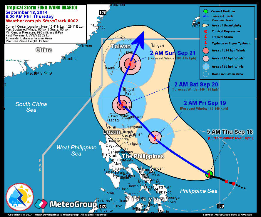
Typhoon FUNG-WONG To Brush Past N. Philippines Tomorrow, Taiwan Saturday And Hit Japan Tuesday

Satellite image of typhoon Fung-wong taken at 0000 Hrs, GMT today, September 18, 2014

The expected path of Typhoon Fung-wong

XWF FORECAST MAP: Fung-wong about to hit Japan on Tuesday, September 23, 2014 (Local Time)

Earlier we had said that Typhoon Fung-wong would pass by northern Philippines. But it seems it going to change course and pass by Philippines very close. It is also going to affect Taiwan brushing past it on Saturday (September 20, 2014).

It will then move on and hit Japan on Tuesday (September 23, 2014) local time.

Fung-wong will not be very strong as it passes Philippines and Taiwan with winds of about 80 kph. It is only when it enters the Yellow Sea that it will really intensify with winds gusting at above 100 kph. Earlier we had estimated that it would hit central Japan but it is going to shift course from earlier forecasts and hit Japan head-on.

XWF FORECAST MAP: Fung-wong moves past N. Philippines tomorrow

XWF FORECAST MAP: The typhoon will affect Taiwan on Saturday

From http://www.trust.org/item/20140918030720-8exfz/?source=fiTheWire


Tropical storm Fung-wong is forecast to strike the Philippines as a typhoon at about 12:00 GMT on 19 September. Data supplied by the US Navy and Air Force Joint Typhoon Warning Center suggest that the point of landfall will be near 18.5 N, 122.4 E. Fung-wong is expected to bring 1-minute maximum sustained winds to the region of around 120 km/h (74 mph). Wind gusts in the area may be considerably higher.


According to the Saffir-Simpson damage scale the potential property damage and flooding from a storm of Fung-wong's strength (category 1) at landfall includes: Storm surge generally 1.2-1.5 metres (4-5 feet) above normal. No real damage to building structures. Damage primarily to unanchored mobile homes, shrubbery, and trees. Some damage to poorly constructed signs. Some coastal road flooding and minor pier damage. There is also the potential for flooding further inland due to heavy rain.


READ MORE ON TYPHOON FUNG-WONG

SIDELIGHTS: VIDEO: A PRETTY TAIWANESE TV FORECASTER TELLS US ABOUT "FUNG-WONG"


Share this PostPin ThisShare on TumblrShare on Google PlusEmail This

FUTURE STORMS: Typhoon FUNG-WONG Is Forming Now (96W): Will Hit Japan September 21, 2014

Expected Path of Tropical Cyclone Fung-wong

As Tropical Storm Kalmaegi dissipates over Vietnam, another typhoon has already been spawned. A low pressure has formed east of Philippines. It has been termed 96W. The JTWC calls it WTPN 21.  In the next few days it will intensify into a tropical storm. Fung-won is coming.

The system will not hit Philippines. It will move towards northern Philippines initially as it gains strength, but will veer away northwards towards in a day or two. It will be a low pressure area or a tropical depression then.

On the 20th of September it will turn into tropical storm Fung-wong. It will slam into Japan at the east coast on 21st September, 2014.

XWF FORECAST MAPS: Fung-won moving past northern Philippines as a tropical depression on 19/9/2014

XWF FORECAST MAPS: Fung-wong hits central Japan on 21/9/2014


Point of impact

READ MORE ON TYPHOON FUNG-WONG
Share this PostPin ThisShare on TumblrShare on Google PlusEmail This

Latest Forecasts/Updates


Popular Posts

Search This Site