Showing posts with label Keila. Show all posts

Oman In For Rains Thanks To Little Keila


Now who would have thought it would turn out this way? The storm in the Arabian Sea in June 2011 (Remember it?) traversed from Kerala all the way to the Gujarat coast; took ten days to do that and what happened? It was not even honored with a name (IMD called it 01A)! And this piddly little short-lived storm off the South Oman coast gets the name Keila!

Anyway.

Oman is in for rains for the next 2-3 days due to Keila. The rains will dry up in the rest of Oman after Keila moves away weakened, below storm strength, into Yemen. But not Muscat. Muscat will keep getting showers till at least the 8th of November, 2011.

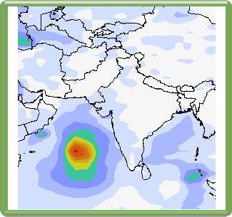
 Lots of rains presently in Oman and the sea thanks to Keila

In the next two days Omani towns of Sadh, Saladah, Raysut, Mudhay, Thamarit and Marmul are in for a drenching. The rest of the country too will get light to heavy falls in the next 2 days

Oman is likely to get more rains around November 14-15, 2011 owing to new storm that is going to get spawned in the mighty Arabian Sea. But more about that elsewhere.

Track/Path of Keila
Share this PostPin ThisShare on TumblrShare on Google PlusEmail This

Monster Cyclone To Slam Pakistan Coast On November 9, 2011


The Arabian Sea this November is in ferment. While a depression hovers around the south Oman coast and will bring rain to the country for the next 3 days, another storm is likely to be spawned in the sea near the Indian coast off Kerala on 3rd of November. This little system will at first take baby steps in a WNW direction, growing bigger all the time for the next 4 days (till Nov 7, 2011). It will then turn into a big monster and start curving gradually northward and hit the Pakistan coast on November 9, 2011.


Boy! This baby is going to be massive! As it nears the Pakistan landmass its diameter will touch the Omani coast on one side and the Gujarat coast on the other side. Huge! 


Surprisingly this big girl (Keila?) will bring little or no precipitation to Oman and Gujarat but Sindh and Balochistan are in for a big big deluge on November 9, 10. 


And winds? Very strong winds. Destructive would describe it well. Watch out, Pakistan!


Eight more days. Where will Keila (If  I may call her so) go? Pakistan, as predicted now, or will Oman (Or Gujarat ) will face its fury?


Cyclones are very unpredictable.


Keep reading this site for updates.....


Arabian Sea Nov 2011 Cyclone Keila Forecast Maps

 Nov 3, 2011. Keila is born off Kerala coast

 Novemeber 7, 2011. Keila is a big bad girl now

 November 9, 2011. Big Cyclone just hitting the Pakistan coast. The red color shows very strong winds

Rainfall forecast map. Nov 9, 2011. Keila brings a deluge to Pakistan
Share this PostPin ThisShare on TumblrShare on Google PlusEmail This

Keila Is Coming Today! Will Hit Pakistan Coast Monday (June 13, 2011) Evening


Keila Is Coming! Finally! She will awake from her 'hibernation', gain strength and hit the Saurashtra coast by today (Saturday, June 11, 2011) evening. Keila will be a little girl. A cyclone with wind speeds of 80+ Kmph. Though she might have her nasty spells. 


Contrary to earlier predictions Keila is going to enter the Saurashtra coast more then expected before. It is also going to hit the area around Karachi (Monday, June 13, 2011) evening bang on. It will then peter out  Wednesday (June 15, 2011) near the Pakistan coast (Gwadar area).


The dampener is that another prediction model, EFS says the low pressure area in the Arabian Sea is going to fizzle out soon. Not even touch the Saurshtra coast. The forecast in this article is based on the GFS model. I generally prefer the GFS. EFS, I feel, is too timid at times.


LATEST JTWC BULLETIN

THE AREA OF CONVECTION PREVIOUSLY LOCATED NEAR 18.4N
70.2E, IS NOW LOCATED NEAR 19.2N 71.2E, APPROXIMATELY 95 NM WEST OF
MUMBAI, INDIA. ....THE LLCC IS CURRENTLY DRIFTING TO THE NORTHEAST. MAXIMUM SUSTAINED SURFACE WINDS ARE ESTIMATED AT 28 TO 33 KNOTS. MINIMUM SEA LEVEL PRESSURE IS ESTIMATED TO BE NEAR 999 MB. THE POTENTIAL FOR THE DEVELOPMENT OF A
SIGNIFICANT TROPICAL CYCLONE WITHIN THE NEXT 24 HOURS REMAINS HIGH.

ARABIAN SEA CYCLONE LATEST XTREME FORECASTS

  • Keila will touch the Saurashtra coast today (Saturday, June 11, 2011) evening near the Diu-Veraval stretch.
  • The coastal towns of Diu, Veraval, Pobandar, Dwarka, Kandla, Mundra, Mandvi will see high speed winds. 80+ Kmph. Interior Saurashtra will have lower winds. 50+ Kmph.
  • Keila will hit the Pakistan coast on Monday (June 13, 2011). Including Karachi.High speed winds of 80+ Kmph.
  • The storm will subside on Wednesday near Gwadar.
  • Heavy showers are expected on the coastal areas of Saurashtra and in Karachi.
EXPECTED PATH OF CYCLONE KEILA


 Saturday Night. June 11, 2011. Keila touches Saurashtra coast

 Monday (June 13, 2011) Keila passes Kutch.

 Tuesday (June 14, 2011) morning (Local time). Keila reaches Karachi

Wednesday (June 15, 2011) evening. End of Keila near Gwadar.
Share this PostPin ThisShare on TumblrShare on Google PlusEmail This

Keila Taking Her Time. Will Touch Saurashtra Saturday Noon

Keila is a lazy girl.She has been sitting and brooding off the coast of Mumbai since many days. It has led to many of us from losing interest in her. Lazy girl. But JTWC (Joint Typhoon Warning Center) thinks otherwise. Keila is going to move  and grow big. She is expected to touch Saurashtra coast by Saturday (June 11, 2011) noon.


She will potter around Saurashtra till Monday (June 13, 2011) and then rapidly intensify, flirt with the Pakistani coast and then move along in the sea and then suddenly collapse Wednesday noon. Baluchistan will not fall to the charms of Keila. But coastal Saurashtra-Kutch and Sind will see big gusts of wind. 70+Kmph.


Rains? Some rains in coastal Saurashtra and Sind.


Keila will never turn into a big bad girl like Katrina. She will remain a little girl. But who knows?


Keila will be at her strongest when she leaves Indian shores.


Ironically Keila's remnants might bring some rain to Oman after all.On Wednesday. June 15, 2011

 Keila will touch Saurashtra coast by Saturday (June11, 2011) noon. As a depression perhaps?

Keila will be strongest on Tuesday (June 14, 2011) morning. Before she dissipates soon after.


Keila disintegrates. Wednesday June 15, 2011
Share this PostPin ThisShare on TumblrShare on Google PlusEmail This

Latest JTWC News On Arabian Sea Storm


LATEST BULLETIN FROM JTWC (JOINT TYPHOON WARNING CENTER)

FORMATION OF A SIGNIFICANT TROPICAL CYCLONE IS POSSIBLE WITHIN
A 120 NM RADIUS OF 18.4N 70.3E WITHIN THE NEXT 12 TO 24 HOURS.

DUE TO CONTINUED FAVORABLE ENVIRONMENTAL CONDITIONS, THE POTENTIAL FOR THE DEVELOPMENT OF A SIGNIFICANT TROPICAL CYCLONE WITHIN THE NEXT 24
HOURS REMAINS HIGH.


Share this PostPin ThisShare on TumblrShare on Google PlusEmail This

Tropical Storm To Hit Saurashtra Friday (June 10, 2011) Noon.


The present low pressure area in the Arabian Sea is likely to move north towards the Saurashtra coast and turn into a deep depression by the time it touches Diu at the southern tip of the peninsula. It will continue as a depression during the following two days as it moves along the coastal areas. By Sunday (June 12, 2011) it will  intensify rapidly into a cyclone. It will be leaving Gujarat waters by then. I guess it will be christened as "Keila" then. It will skim coastal Pakistan till Tuesday (June 14, 2011) when it will make landfall at Gwadar, near the Pakistan-southern Iran border. It will dissipate soon after.


WHAT THE JTWC SAYS (LATEST)


FORMATION OF A SIGNIFICANT TROPICAL CYCLONE IS POSSIBLE WITHIN
A 160 NM RADIUS OF 18.7N 69.8E WITHIN THE NEXT 12 TO 24 HOURS.
AVAILABLE DATA DOES NOT JUSTIFY ISSUANCE OF NUMBERED TROPICAL CY-
CLONE WARNINGS AT THIS TIME.
THE POTENTIAL FOR THE DEVELOPMENT OF A SIGNIFICANT TROPICAL CYCLONE 
WITHIN THE NEXT 24 HOURS IS UPGRADED TO HIGH. 
LATEST ARABIAN SEA TROPICAL STORM FORECAST
  • The low pressure presently standing stationary west of Mumbai will slowly start moving north. By the time it touches the Saurashtra (India) coast Friday (June 10, 2011) morning it will have turned into a deep depression.
  • It will move along the Saurashtra coast for the next two days. By Sunday (June 12, 2011) when it leaves Indian waters near Dwarka, it will intensify rapidly into a cyclone.
  • This cyclone, which will be named "Keila", will skim along the Pakistani coast and only make landfall at Gwadar in Balochistan om June 14, Tuesday. After which it will dissipate on the Balochistan-southern Iran border.
  • All the coastal towns in India; Diu, Verval, Porbandar, Dwarka and Karachi in Pakistan will see high speed winds. 80+Kmph.
  • Fishermen in both Gujarat and Sindh are warned not to venture into the sea from Friday (June 10, 2011) to Tuesday (June 14, 2011). The storm will mostly be moving in the sea so the winds there will be much more than the land areas. Wind speeds in the seas near the Gujarat and Sindh coast will be very high. 150+ Kmph.
PREDICTED PATH OF THE STORM
 Friday noon. Tropical depression touches the Saurashtra coast
 Saturday (June 11, 2011) morning. Depression weakens a little and moves along the coast
 Sunday (June 12, 2011) late night. Keila gains strength rapidly
 Tuesday (June 14, 2011) noon. Keila hits Gwadar
Wednesday night (June 15, 2011) The end of Keila.
Share this PostPin ThisShare on TumblrShare on Google PlusEmail This

Cyclone Keila To Form Today, Will Touch Saurashtra Coast Friday Morning

Let me tell you how cyclones are born. They start off as a low pressure area. Then they get stronger and develop in a depression. Then intensify into a deep depression. If it gains further strength, a cyclone is born. It are also called a hurricane,  typhoon or a severe tropical storm.

Keila has taken birth. It is a low pressure area now. It lies now at 18.7N 69.8E . It is 180 miles west of Mumbai. She is expected to grow bigger and stronger into a depression and start moving north towards the Saurashtra coast. By the time it reaches Diu (Friday June 10 morning) on the southern tip of the Saurashtra peninsula it will have turned into a cyclone. Albeit a small cyclone. Windspeeds of 80 Kmph. Keila will then move along the Saurashtra coast till Saturday (June 11, 2011) evening. It is when it leaves Saurashtra (Saturday morning) that the storm will rapidly gather strength. Turn bigger with wind speeds of 120+ Kmph. Keila's periphery will touch Karachi and she will move into Baluchistan (Gwadar) Tuesday  June 14 morning. Gwadar will face the most fury of the cyclone.


June 9, 2011 Thursday 06.15 AM (GMT,UTC)


THE AREA OF CONVECTION PREVIOUSLY LOCATED NEAR 19.1N  69.7E, IS NOW LOCATED NEAR 18.7N 69.8E, APPROXIMATELY 180 NM WEST OF MUMBAI, INDIA.
DUE TO DECREASING PRESSURES, PERSISTENT DEEP  CONVECTION, AND INCREASINGLY FAVORABLE ENVIRONMENTAL CONDITIONS, THE POTENTIAL FOR THE DEVELOPMENT OF A SIGNIFICANT TROPICAL CYCLONE WITHIN THE NEXT 24 HOURS IS UPGRADED TO HIGH.

ARABIAN SEA TROPICAL STORM LATEST FORECAST

  • Keila (If I may call the lady so now) is going to intensify today and start moving north. It will touch the Saurashtra coast by Friday (June 10, 2011) morning. She will weaken a little as she meets Saurashtra.
  • She will move along the Saurashtra coast till Sunday (June 12, 2011) morning. Then as leaves Indian waters it will rapidly gain strength and turn into a big cyclone. Keila's edges will touch Karachi (Deadly touch!).
  • Keila will hit Baluchistan, especially Gwadar, Tuesday, June 14, 2011, morning. And hit it really hard. Wind speeds in excess of 150+ Kmph.
  • It will dissipate by Wednesday (June 15, 2011) evening over southern Iran
  • In India the Saurashtra towns of Diu, Veraval, Porbandar, Dwarka will see the most of Keila. Dwarka especially will be severely hit. All of Saurashtra - Kutch will have winds of 70-80 Kmph.
  • Saurashtra - Kutch will receive continuous rains (heavy falls) till Monday. Especially the coastal areas.
  • Southern Sind and Baluchistan will get lots of rain from Sunday (June 12, 2011) to Wednesday (June 15, 2011) evening. By rain I mean downpour. We are talking of 5, 10, 15 inches here. Lots of rain.
Lots of rain in the next one week in the coastal areas of Gujarat, Sind, and Balochistan
    THE LATEST PREDICTED PATH OF KEILA
     FRIDAY (JUNE10, 2011) KEILA SAYS HELLO TO SAURASHTRA. ESPECIALLY DIU.
     FRIDAY NIGHT. A WEAKENED KEILA POTTERS AROUND THE SAURASHTRA COAST
     SUNDAY MORNING. JUNE 12, 2011. KEILA GATHERS STRENGTH AS SHE LEAVES THE GUJARAT COAST
     MONDAY (JUNE 13, 2011) EVENING (PAKISTAN TIME) KEILA ABOUT TO ENTER PAKISTAN
     TUESDAY EVENING. KEILA MAKES LANDFALL INTO BALOCHISTAN
    WEDNESDAY (JUNE 15, 2011) MORNING. END OF THE STORM IN SOUTHERN IRAN
      Share this PostPin ThisShare on TumblrShare on Google PlusEmail This

      TROPICAL STORM ARABIAN SEA: Predicted Rainfall In Gujarat And Southern Pakistan

      Here is the rainfall forecast for Saurashtra and southern Pakistan because of the tropical storm which is expected in a couple of days. Coastal areas of Saurashtra will receive rainfall Friday to Sunday. Some places will get heavy falls. Southern Pakistan will get most of the rains. Especially Baluchistan. The rains will reach Pakistan on Saturday (June 11, 2011)

       Thursday, June 9, 2011 The rain laden clouds move northwards.

       Friday June 10, 2011 Coastal areas of Saurashtra receive rainfall. No heavy falls. Most of the heavy precipitation falls in the sea. Pity.

       Saturday June 11, 2011 Saurashtra Kutch coastal areas keep getting rain. Light to moderate

       Saturday June 12, 2011 Dwarka, Kandla, Mandvi get heavy falls

       Monday June 13 2011 Rains start in Pakistan. Welcome downpours in Karachi

      Tuesday June 14 2011 Heavy falls in parts of Sind and Balochistan
      Share this PostPin ThisShare on TumblrShare on Google PlusEmail This

      Joint Typhoon Warning Center (JTWC) Upgrades Likelihood Of Arabian Sea Storm

      Joint Typhoon Warning Center (JTWC) in its latest bulletin says about the tropical storm in the Northern Indian Ocean (read that as Arabian Sea)
      THE AREA OF CONVECTION PREVIOUSLY LOCATED NEAR 18.3N  70.9E, IS NOW LOCATED NEAR 17.2N 69.8E, APPROXIMATELY 200 NM WEST-SOUTHWEST OF MUBAI, INDIA. THE POTENTIAL FOR THE DEVELOPMENT OF A SIGNIFICANT TROPICAL CYCLONE WITHIN THE NEXT 24 HOURS IS UPGRADED TO MEDIUM.
       
       
      Share this PostPin ThisShare on TumblrShare on Google PlusEmail This

      LATEST! Balochistan To Bear The Brunt Of Keila's Fury

      Latest forecast for the tropical storm in the Arabian Sea is that it is going to touch the Saurashtra coast (periphery of Keila) at Diu and Veravel Friday (June 10, 2011) morning. It will not enter Saurashtra but it will move along the coast; its periphery touching the Saurashtra coast.  It will move similarly into Pakistani waters. Karachi will feel only the edges of Keila. The storm will make landfall (Monday June 13 morning) in Baluchistan province, which will feel the full fury of Keila. Kolwa, Bela, Pasni, and Turbat towns in Baluchistan are likely to be most affected


      KEILA FORECAST UPDATES

      • The present low pressure area in the Arabian Sea will start intensifying and assume an avatar of a full fledged cyclone Thursday (June 9, 2011) afternoon with a well marked 'eye' when it touches Diu in the Saurashtra (India) coast.
      • The Met departments in India and Pakistan will start mentioning a " deep depression" by Thursday (June 9, 2011) morning. A cyclone warning will follow and the storm will be christened "Keila".
      • Keila will start gaining strength soaking the humidity from the Arabian Sea and move northwards. Its periphery will touch Diu Friday (June 10, 2011). morning.
      • It will then change direction heading north westerly moving along the Saurashtra coast.
      • Karachi will see the approach of Keila Saturday (June 11, 2011) afternoon. Keila will make landfall (Sunday evening, June 12, 2011) in Balochistan province of Pakistan, which will bear the brunt of the tropical cyclone.
      • Diu, Veraval, Porbandar, Kandla, Mandvi in Saurashtra (India) will witness winds of 80 Kmph. Karachi will see similar winds. Balochistan will be the windiest. 120+ Kmph.
      • Coastal areas of Saurashtra Kutch and Sind will receive lots of rain. Balochistan will suffer downpours. Floods area distinct possibility.
      PREDICTED PATH OF KEILA

       Friday (June 10, 2011) morning. Keila nudges Saurashtra coast

       Saturday (June 11, 2011). Moving past Kutch

       Sunday evening. Touches Pakistan coast.

      Monday (June 13, 2011) morning. Keila enters Balochistan.


      IN THE MEANTIME.......


      The Naval Oceanography Operations Command (NOOC) of the US Navy says in its latest report


      THE AREA OF CONVECTION PREVIOUSLY LOCATED NEAR 18.3N  70.9E, IS NOW LOCATED NEAR 17.2N 69.8E, APPROXIMATELY 200 NM WEST-SOUTHWEST OF MUBAI, INDIA. THE POTENTIAL FOR THE DEVELOPMENT OF A SIGNIFICANT TROPICAL CYCLONE WITHIN THE NEXT 24 HOURS IS UPGRADED TO MEDIUM.
      Share this PostPin ThisShare on TumblrShare on Google PlusEmail This

      Keila Latest: Will Touch Saurashtra Coast Friday Morning, Karachi Sunday Morning

      The expected tropical storm in the Arabian Sea is likely to gather strength by Wednesday (June 8, 2011). It will then keep intensifying for the next two days and then touch the Saurashtra coast by Friday (June 10, 2010) near Diu. It will then keep moving along the Saurashtra coast and then pass into the Pakistani coast. It will then enter south-western Pakistan (Gwadar) and start dissipating. Indian coastal towns of Diu, Veraval, Porbandar, Dwarka, Kandla, Mandvi are likely to be most affected. Though the "eye" of Keila will remain in the sea. Karachi is likely to feel the periphery of Keila (Wind speeds of 100 kmph+). Oman can take a sigh of relief. Keila is not going to make a date with it.

      KEILA FORECAST UPDATES
      • The presently dormant low pressure area in the Arabian Sea (19.3 N and 75 E) will start slowly intensifying by tomorrow (Wednesday, June 8, 2010). It will start moving northwards towards the Saurashtra (Gujarat, India) coast  and turn into a depression. By Thursday morning it will start turning into a cyclone. Perhaps it will then officially gets its name "Keila".
      • It will rapidly move northwards and touch the Saurashtra coast at Diu by early Friday (June 10, 2011) morning.
      • It will then saunter along the Saurashtra coast and then the coast of Kutch in the next two days. The good news is that Keila's periphery will touch the Saurashtra coastal towns. Keila's centre, its "eye" will remain in the Arabian Sea offshore.
      • Even then wind speeds will be considerable. 80 Kmph+
      • The Indian towns (Saurashtra coast) of Diu, Veraval, Porbandar, Dwarka, Kandla, Mandvi, Mundra will be affected the most.
      • Keila will meet the Pakistan coast on Sunday (June 12, 2011) evening. Karachi is to be affected. Keila will then move into land, into Balochistan, Pakistan by Sunday evening (Pakistan Time). Balochistan will see the strongest winds. 120+ Kmph.
      • Keila will then move into southern Iran and dissipate. 
      • Lots of rainfall likely in coastal Saurashtra, Southern Pakistan (Karachi) and Balochistan as the storm passes by.
      • Oman will not be affected in the least. 
      PROJECTED PATH OF KEILA (FORECAST IN MAPS)
      Note: I Knot = 1.85 Kmph 
      The UTC time shown in the maps is the same as GMT


       Early Friday (June 10, 2011) morning. Keila prods Diu awake with wind and heavy rain

       Friday night (June 10, 2011). Keila has spread her tentacles to all the coastal areas of Saurashtra and Kutch
       Keila perhaps likes the place. Hovers around for 24 hours
       Starts moving again. Sunday night. June 12, 2011. Nudging Pakistan and Karachi
       Monday (June 13, 2011) afternoon. Enters land. Parts of Sindh and Balochistan
      Monday (June 13, 2011) Starts dissipating near the Iran border.
        Share this PostPin ThisShare on TumblrShare on Google PlusEmail This

        Latest Forecasts/Updates


        Popular Posts

        Search This Site