Showing posts with label super cyclone. Show all posts

NILOFAR UPDATE: 2:30 PM GMT Oct.28,2014: Cyclone Nilofar To Turn Into Category 4 Storm (Super Cyclone) Tomorrow


Nilofar is going to be bigger than expected. In an earlier update we had hinted at a Category 3 Hurricane. The lady is going to be a bigger killer than expected. A Category 4 storm.

Yes, come tomorrow morning and it will turn into a massive storm with winds of 230-280 Kph. We can safely call it a super cyclone. (The IMD says winds above 222 Kph makes a super cyclone). Thank God that it is not going to hit Oman!

That is what the JTWC says in its latest bulletin at 3 PM, GMT, October 28, 2014.

Though NOAA says it will be strongest with only 195 Kph winds by tomorrow evening. That would make it a Category 3 hurricane.

The update adds that it will weaken a lot before landfall at Narayan Sarovar in Kachchh (Gujarat) on Saturday afternoon (November 1, 2014). The winds will be about 75 Kph gusting up to 90 Kph

VIDEO: BIRTH OF A MONSTER: CYCLONE NILOFAR TODAY (OCTOBER 28, 2014)


Share this PostPin ThisShare on TumblrShare on Google PlusEmail This

Super Storm KAMMURI To Develop In Next Few Days: Will Pass By Japan On September 29, 2014

LATEST JTWC WARNING SAYS.....

FORMATION OF A SIGNIFICANT TROPICAL CYCLONE IS POSSIBLE WITHIN 135 NM EITHER SIDE OF A LINE FROM 11.9N 148.1E TO 17.5N 147.9E  WITHIN THE NEXT 12 TO 24 HOURS. AVAILABLE DATA DOES NOT JUSTIFY ISSUANCE OF NUMBERED TROPICAL CYCLONE WARNINGS AT THIS TIME. WINDS IN THE AREA ARE ESTIMATED TO BE 18 TO 23 KNOTS. METSAT  IMAGERY AT 091830Z INDICATES THAT A CIRCULATION CENTER IS LOCATED NEAR 12.4N 148.1E. THE SYSTEM IS MOVING NORTH-NORTHWESTWARD AT 10 KNOTS.

Latest forecasts say KAMMURI will kiss central Japan and move away on September 29, 2014, But who knows what might happen?

In the next few days, a much bigger storm than Fung-wong will take birth in the western Pacific. Kammuri. Typhoon Kammuri will form near the Mariana Islands in the Pacific.

In the next few days, it will move NNW towards central Japan. It will approach the country till the 29th of September giving Japan a scare, because Kammuri will be a big storm with a very large radius (Fung-wong was a pygmy by comparison).

But then suddenly it will move away north-easterly from Japan into the deep Pacific ocean.

Going by present forecasts, Kammuri will not hit Japan. All it will do is devastate the islands in its path (Volacano Islands, Bonin Islands, Iwo Jima) but these are sparsely populated.

Make no mistake; Kammuri is going to be big monster.

If it decides to hit Japan, it will be devastating.

XWF FORECAST MAP: This the closest super-typhoon "Kammuri" will get to Japan. After 29/9/2014 it will move away from the country


Present predicted path of KAMMURI


The JTWC warns of the birth of Kammuri


This satelliteiamge taken at 0000 Hrs GMT, 3rd September, 2014, shows the birth of Kammuri near the island of Guam
Share this PostPin ThisShare on TumblrShare on Google PlusEmail This

Some Latest Videos Of Super Typhoon NEOGURI As It Hits Okinawa


Neoguri hits Okinawa


INCOMPLETE....WORK IN PROGRESS

Share this PostPin ThisShare on TumblrShare on Google PlusEmail This

Super Cyclone NEOGURI Is Entering Japan Now


Satellite image of Neoguri taken today (July 7, 2014) at 9:00 AM GMT.

Infra-red satellite image of super typhoon Neoguri taken today at 4:53 AM GMT (July 7, 2014)


As we write this the first super cyclone of the year is about to hit the Japanese island of Okinawa. Neoguri is a monster, make no mistake about that. JTWC warns that it could whip up winds of 175 knots (The KTS in the map above is knots not kph. 1 knot=1.825 kph).That means winds of a devastating 325 kph. Japan is in for trouble.

Nasa satellite image of Neoguri as it moves past Taiwan.
Share this PostPin ThisShare on TumblrShare on Google PlusEmail This

Just One Point: Please Don't Question Our Integrity

Someone just wrote to us...."Kindly be accurate in giving out the information as this is a serious matter which needs to be addressed and prepared for. Just don't give the Prediction and projections unless it is positively CONFIRMED."

 We replied...."We know this is a serious matter. If one is looking for 100% confirmed forecasts, this is not possible in today's world even with the biggest supercomputers, as any meteorologist will tell you. If one is looking for greater accuracy, then wait for the weather bulletins by the country's Met office. What we do is give indications of a possibility of a tropical storm WELL IN ADVANCE. Sometimes we are proved wrong; Sometimes we are proved right. We are bloggers, not the country's official Met department. And our forecasts are based on real trusted forecast models, not our whims and fancies"
Link

Share this PostPin ThisShare on TumblrShare on Google PlusEmail This

Latest Cyclone NILAM Predicition: Nov. 3, 2012: Target Kutch!

Novemeber 3, 2012. Cyclone NILAM hits the Gujarat coast
Latest predictions of Expected Cyclone NILAM say that the Target is going to be Kutch area in Gujarat. The latest predictions vary little from our yesterday's analysis.

NILAM is going to be big. May be a super cyclone. (See the image below). It is going to hit the Gujarat coast in Kutch district on November 3rd, 2012.


Projected path of Cyclone NILAM. October 30, 2012 to November 3, 2012

So big the storm is going to be that the entire western region of India; the states of Gujarat, Rajasthan and coastal Maharashtra are going to receive rains. The most drenching is reserved for Kutch in Gujarat and Rajasthan. 

So massive and strong is tha system that it may move inwards into India cut across Rajasthan and give rains to Delhi and Uttaranchal too! All these states will get massive rains till the 5th of November., 2012.

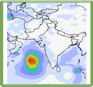
Rainfall Prediction Map: Cyclone NILAM: October 31, 2012 to November 4, 2012.

Share this PostPin ThisShare on TumblrShare on Google PlusEmail This

Monster Cyclone To Slam Pakistan Coast On November 9, 2011


The Arabian Sea this November is in ferment. While a depression hovers around the south Oman coast and will bring rain to the country for the next 3 days, another storm is likely to be spawned in the sea near the Indian coast off Kerala on 3rd of November. This little system will at first take baby steps in a WNW direction, growing bigger all the time for the next 4 days (till Nov 7, 2011). It will then turn into a big monster and start curving gradually northward and hit the Pakistan coast on November 9, 2011.


Boy! This baby is going to be massive! As it nears the Pakistan landmass its diameter will touch the Omani coast on one side and the Gujarat coast on the other side. Huge! 


Surprisingly this big girl (Keila?) will bring little or no precipitation to Oman and Gujarat but Sindh and Balochistan are in for a big big deluge on November 9, 10. 


And winds? Very strong winds. Destructive would describe it well. Watch out, Pakistan!


Eight more days. Where will Keila (If  I may call her so) go? Pakistan, as predicted now, or will Oman (Or Gujarat ) will face its fury?


Cyclones are very unpredictable.


Keep reading this site for updates.....


Arabian Sea Nov 2011 Cyclone Keila Forecast Maps

 Nov 3, 2011. Keila is born off Kerala coast

 Novemeber 7, 2011. Keila is a big bad girl now

 November 9, 2011. Big Cyclone just hitting the Pakistan coast. The red color shows very strong winds

Rainfall forecast map. Nov 9, 2011. Keila brings a deluge to Pakistan
Share this PostPin ThisShare on TumblrShare on Google PlusEmail This

Latest Forecasts/Updates


Popular Posts

Search This Site