Showing posts with label september. Show all posts

Future Monster Hurricane MATTHEW May Go Anywhere

SEPTEMBER 29, 2016, THURSDAY 

Tropical storm Matthew slowly moving west in the Carribeans has forecast models pointing at different directions when the future track of this soon to be monster hurricane is concerned.

Yesterday we had hinted it could hit Miami, Florida on October 6-7, 2016. This prediction we had based on the ever reliable European model, ECMWF. Today the ECMWF is predicting a different path. It expects a direct hit on Haiti on October 5, 2016. This model further says that this storm is going to be even stronger than earlier expected. After passing Haiti, it will intensify into a category 4 monster reaching a central minimum pressure of 927 hPa. That means winds in excess of 120 knots. Possibly Bermuda is in for a royal thrashing.

But as we said earlier different forecast models are saying different things. The National Hurricane Center says Cuba is for a rendezvous with Matthew. But it remains silent on where the hurricane will go after that. Head for Florida? Or swing away into North Altlantic Ocean?

The present situation is that it could go anywhere, from states adjoining the Gulf of Mexico (seems unlikely) to a hit on Florida (less unlikely) or sailing away into the Atlantic after giving Haiti or Cuba a good hiding.


UPDATE: SEPTEMBER 30, 2016, FRIDAY

Though the official National Hurricane Center forecast predicts hurricane Matthew will move through Cuba and into the Altlantic, the threat to Florida remains. The reliable ECMWF model foresees a hit on the state. Supporting it is the NHC-LBAR model. Even the GDFL and GDFN models predict a path close to Florida.

This storm has many folks in the weather forecasting community on tenterhooks. The red line is the ECMWF prediction. The white line with red dots is the official NHC forecast.


Share this PostPin ThisShare on TumblrShare on Google PlusEmail This

Monster Typhoon MEGI (Helen) Born In West Pacific Ocean: Target Taiwan September 28, 2016

SEPTEMBER 21, 2016, WEDNESDAY 
 
Deep in the Pacific Ocean just north of the Micronesian island of Chuuk, an innocuous low pressure area has just turned into a depression. The Japanese Meteorological Agency JMA which monitors that part of the world has sat up and started keeping track.
 
For good reason. In a week's time, this tiny system in the mighty Pacific Ocean is going to metamorphose into a howling monster called MEGI, a category 2 or 3 typhoon that will slam into Taiwan head on. The diameter of this future storm will be larger than the length of the country.
 
Almost all forecast models predict the impact to occur around September 28, 2016, give or take a couple of days.
 
Our estimate is at its peak as MEGI will be hurtling towards Taiwan, it's central minimum pressure may sink to 960 hPa. It's 10 minute sustained winds will be 180-200 km/h.
 
One shudders to think what that will do to Taiwan, a country which has been battered by numerous storms in the last 15 days.
 
Contrary to earlier expectations, typhoon MEGI may spare Luzon, Philippines. But Guam will come in its way while it will be growing, intensifying and moving west. 

The track of this storm is not 100% certain. The European model thinks it will batter between Taiwan and Luzon and go onto hit China at Guangdong province. May be pleasure spot Macau and Hong Kong may receive a royal thrashing. Taiwan may escape the full wrath of this monster if that happens.

Unfortunately, it is possible that another typhoon CHABA (Igme in Philippines) will hit Taiwan on October 4, 2016, after MEGI (Helen). CHABA is likely to be as powerful as MEGI. Bad tidings for the country.
 
Typhoon MEGI Taiwan September 2016
 
Share this PostPin ThisShare on TumblrShare on Google PlusEmail This

Typhoon MALAKAS To Drench Japan, Future MEGI Threatens Philippines On September 26

SEPTEMBER 19, 2016, MONDAY
 
The western Pacific Ocean is hurling storms by the fistful. Even as a weakening typhoon MALAKAS prepares to drench Japan as it slices though the eastern coast of the country, another typhoon MEGI is likely to hit Luzon, Philippines in a week, around September 26, 2016.
 
MALAKAS will hit Kyushu island east of Kagoshima city at about 1300 hours GMT, today with sustained winds of 150 km/h. It's wind intensity will decrease rapidly as it moves through the eastern coast of Japan. By the time it passes by Tokyo after 48 hours on September 21, 2016, it will be a mere tropical depression. But the typhoon will bring heavy rains in the country. Kyushu island is expected to receive 12 inches of rainfall in the next 24 hours.
 
Meanwhile another west Pacific Ocean typhoon MEGI may hit Luzon, Philippines on September 26, 2016. This typhoon may further intensify as it enters the South China Sea and hit the Chinese coast at Macau/Hong Kong on September 28, 2016.

At this stage it is difficult to be sure as to the expected track of typhoon MEGI. Other forecast models are saying it may just skim northern Luzon and hit Taiwan on September 29, 2016.
 
Typhoon MALAKAS Japan September 2016 track forecast
Typhoon MALAKAS Japan September 2016
 
 
Share this PostPin ThisShare on TumblrShare on Google PlusEmail This

Mumbai, Konkan Faces Deluge On September 24, 2016

SEPTEMBER 15, 2016, THURSDAY 

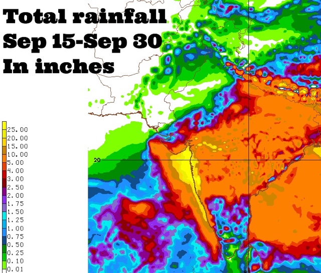
Coastal Maharashtra and the city of Mumbai are in for extremely heavy rains around September 24, 2016. Some forecast models suggest about 25 inches of rain in these places by the end of the month. 

The rest of Maharashtra, south Gujarat, some districts of Saurashtra and north, central Gujarat may also receive 2-5 inches of rain at that time.

This is going to happen because a Bay of Bengal cyclonic circulation will clamber over peninsular India, emerge near the Konkan coast in the Arabian Sea around September 24 and intensify into a well marked low pressure area.

Where will the low pressure system go after that? Hard to say now. Some forecast models say it will weaken and move into northern Maharashtra-western Madhya Pradesh. But this is not certain.

It might well decide to take a stroll in the Arabian Sea.
----
"Latest GFS forecast says the Arabian Sea low pressure system will hit northern Oman on September 29, 2016 with heavy rains."
----
Things are going to happen in the coming days in the Indian west coast. Mumbai. Prepare for floods. The GFS model says heavy showers in Konkan, Mumbai will start much before September 24. In the next few days. Heavy rains are expected in Maharashtra on September 17-18.

Very heavy rains are possible in Mumbai in next 72 hours. This will be just a precursor to the expected deluge on September 24.

Forecast models are predicting a sudden explosion of monsoon activity with two strong low pressure systems developing, one each in the Arabian Sea and Bay of Bengal around September 24, 2016. That day seems to be D-Day. Deluge day.

Situation presently is fluid. So it is hard to say where the rain systems will go. One thing is certain. Some places in South/West Asia are in for a lot of rains in the coming days.


Share this PostPin ThisShare on TumblrShare on Google PlusEmail This

Arabian Sea Depression May Hit Oman With Rains On September 25, 2016

SEPTEMBER 10, 2016, SATURDAY 

Forecast models are hinting at the formation of an Arabian Sea low pressure area/depression in the coming days. The American GFS model expects it to form off the Mumbai-Konkan coast on September 19, 2016.

This system may intensify into a deep depression as it nudges the Saurashtra coast and head straight west towards northern Oman, reaching it on around September 24, 2016. 

The GFS only says it will be a depression. But there are still 10-15 days to go and a tropical cyclone cannot be ruled out. 

Other forecast models confirm a low pressure area on Maharashtra on September 19. But they do not attest to the GFS prediction of an Arabian Sea storm. We have to wait a few days for the confirmation. This system will come over from the Bay of Bengal. This is the same cyclonic circulation which is dancing around the eastern coast of India. This is expected to intensify into a low pressure area and move to Maharashtra on September 19-20 via Andhra Pradesh and Telangana.

Meanwhile a depression will move through Vietnam, Laos, northern Thailand and reach southern Myanmar on September 16. But it may fizzle out after that.

The reasons for the disappointing South Asia monsoon this year are 3-fold. 
>The Indian Ocean Dipole, IOD, is negative. 
>La Niña still continues with her nakhras and refuses to come. Conditions are ENSO neutral.
>The storm maker Madden Julian Oscillation, MJO, had gone for a walk in the Pacific Ocean, so central Pacific Ocean is throwing numerous hurricanes. Though chances are a weak MJO may arrive in the Indian Ocean soon. But this is not confirmed. (See MJO diagram below).

UPDATE, SEPTEMBER 11, 2016

The GFS in its later forecasts now rules out an Arabian Sea depression. But there is a good chance of very heavy precipitation in Konkan, Goa and Mumbai around September 25, 2016. We are talking of 10-20 inches of rain in 2-3 days.

Something is going to happen in the Arabian Sea in the coming days. When forecast models give highly erratic predictions for an area, it rings an alarm bell somewhere.


The different phases of MJO. When it is phase 2,3 the North Indian Ocean throws out tropical cyclones.

Share this PostPin ThisShare on TumblrShare on Google PlusEmail This

Two Rain Systems Imminent In India

SEPTEMBER  7, 2016, WEDNESDAY 

The monsoons may be at an ebb now but a strong revival is in the offing in the coming 10 days. Many parts of India, Bangladesh and Myanmar may receive heavy rains.

This will be possible because of two low pressure areas. Both will travel a long time without weakening and cross a long distance. 

Let us discuss in detail.

The first is the low pressure/cyclonic circulation that is hovering over Bengal presently. In the coming days it will move along the coast in the Bay of Bengal. First Odisha then Andhra Pradesh. It will enter the state on September 15 and move through Telangana, Maharashtra and emerge in the Arabian Sea just off the Mumbai coast, south of Saurashtra on September 17. Where it will go after that remains to be seen. It may move into Gujarat. Or it may dissipate in the Arabian Sea. Or it may intensify into a depression or tropical cyclone.

Folks in Gujarat, Oman and Pakistan must track this system with interest. Forecast models say it will intensify after emerging in the Arabian Sea.
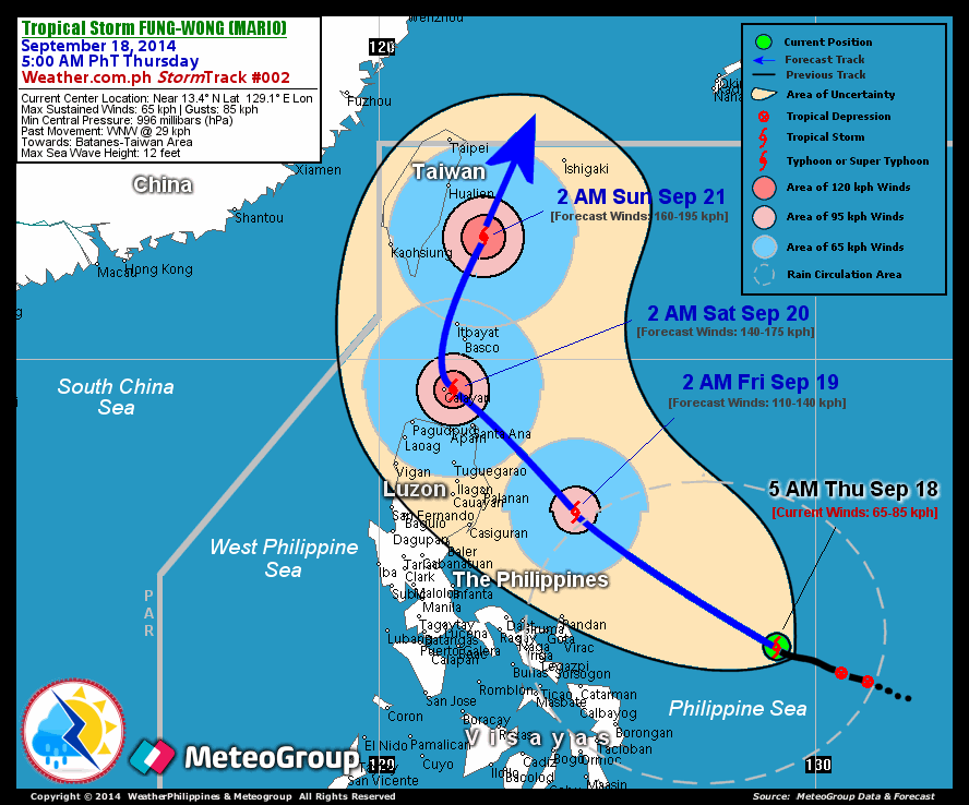
The second rain maker system will come from the South China Sea. It will be born west of the Philippines, intensify into a depression or tropical storm and hit central Vietnam on September 13, 2016. After that it will move through Cambodia, Myanmar, and emerge in the Bay of Bengal near the Bangladesh/Bengal coast and intensify on September 17, 2016.

What this system does after that is uncertain at this stage.

We are not saying a tropical cyclone is imminent in the North Indian Ocean but if forecast models are to be believed a major rain system is likely in both the Bay of Bengal and the Arabian Sea in the coming days.

Let us see.

UPDATE, SEPTEMBER 8, 2016, THURSDAY 

The picture remains hazy. Further latest data from forecast models confirms a strong low pressure area off the Andhra Pradesh coast on September 18. Also confirmed is the tropical storm/depression hitting central Vietnam on September 13. The CFS model predicts heavy showers in Konkan and Mumbai around September 24, 2016.


Share this PostPin ThisShare on TumblrShare on Google PlusEmail This

Indian Monsoon Shows Receding Trend

AUGUST 31, 2016, WEDNESDAY 

The monsoon in India this year has been unremarkable as compared to other years. Though it has rained every where in little or more amounts, there have been few powerful rain systems. There was only one this year. Last month a low pressure system hovered over Madhya Pradesh for a week bringing floods.

Otherwise generally unremarkable. The Indian Met Department has reduced its forecast from above average to average rainfall in 2016. Forecasts by global forecast models of a bountiful Indian monsoon has been proved wrong.

The culprit is La Niña. The absence of it. Expectations that the flooding La Niña would be born in July or August have been belied. September has come and ENSO conditions are still neutral. In short, no La Niña. The monsoon are preparing to withdraw from South Asia.

In the coming days monsoon rains in Rajasthan, Gujarat, Punjab, Haryana will begin to decrease. Unless of course either the Arabian Sea or Bay of Bengal throw out a low pressure system or a depression. None are expected in the near future.

A low pressure area will affect Bangladesh, Bengal and Bihar on September 5-6 bringing good rains. Otherwise it remains sedate in South Asia.

Come October and chances of a tropical cyclone in either Arabian Sea and Bay of Bengal increases.


Share this PostPin ThisShare on TumblrShare on Google PlusEmail This

Tropical Storm "Kammuri" Update: September 27, 2014: Typhoon Will Pass By Japan On Sept. 29, 2014

Infra-Red satellite image of Typhoon Kammuri taken at 0300 Hrs, September 27, 2014

Japan is fortunate. Just a few days there was a real possibility that two typhoons would strike it one after another. But things have changed. Typhoon Kammuri which is hovering around in the Pacific now is not going to strike Japan but pass it by on September 29, 2014.

Typhoon Phanfone which is being spawned right now in the Pacific, will also by-pass Japan in early October. But that we leave for later.

Expected path of Kammuri: From today till September 29, 2014

MET OFFICE PREDICTS THE PATH OF 'KAMMURI'
       GLOBAL MODEL DATA TIME 00UTC 27.09.2014

 SEVERE TROPICAL STORM KAMMURI    ANALYSED POSITION : 24.8N 145.7E

  VERIFYING TIME     POSITION     STRENGTH        TENDENCY
  --------------     --------     --------        --------

 00UTC 27.09.2014  24.8N 145.7E   MODERATE

 12UTC 27.09.2014  27.3N 144.5E   MODERATE  INTENSIFYING SLIGHTLY

 00UTC 28.09.2014  30.1N 143.3E    STRONG   INTENSIFYING SLIGHTLY

 12UTC 28.09.2014  32.1N 144.1E    STRONG       LITTLE CHANGE

 00UTC 29.09.2014  33.4N 146.1E    STRONG       LITTLE CHANGE

 12UTC 29.09.2014  35.7N 149.9E    STRONG       LITTLE CHANGE

 00UTC 30.09.2014  39.0N 156.4E    STRONG       LITTLE CHANGE

 12UTC 30.09.2014  41.3N 164.4E    STRONG    WEAKENING SLIGHTLY

 00UTC 01.10.2014  41.0N 172.1E   MODERATE   WEAKENING SLIGHTLY

 12UTC 01.10.2014        BELOW TROPICAL STORM STRENGTH


XWF WEATHER FORECAST MAP: Typhoon "Phanfone" moves past Japan on October 5, 2015
Share this PostPin ThisShare on TumblrShare on Google PlusEmail This

LATEST UPDATE 0630 HRS GMT 23/9/204: Typhoon Kammuri To Hit Central Japan September 29, 2014

Latest forecasts say upcoming typhoon "Kammuri" will hit central Japan on September 29, 2014.

Earlier we had predicted that the storm will just skim the Japanese coast and move away but the typhoon seems to have changed its mind and will now hit central Japan near Tokyo on September 29, 2014.

Kammuri is going to be a big storm. May be a super typhoon.

Keep reading this site for the latest forecasts.

XWF FORECAST MAP: Kammuri about to hit central Japan on 29th September 2014
Share this PostPin ThisShare on TumblrShare on Google PlusEmail This

Super Storm KAMMURI To Develop In Next Few Days: Will Pass By Japan On September 29, 2014

LATEST JTWC WARNING SAYS.....

FORMATION OF A SIGNIFICANT TROPICAL CYCLONE IS POSSIBLE WITHIN 135 NM EITHER SIDE OF A LINE FROM 11.9N 148.1E TO 17.5N 147.9E  WITHIN THE NEXT 12 TO 24 HOURS. AVAILABLE DATA DOES NOT JUSTIFY ISSUANCE OF NUMBERED TROPICAL CYCLONE WARNINGS AT THIS TIME. WINDS IN THE AREA ARE ESTIMATED TO BE 18 TO 23 KNOTS. METSAT  IMAGERY AT 091830Z INDICATES THAT A CIRCULATION CENTER IS LOCATED NEAR 12.4N 148.1E. THE SYSTEM IS MOVING NORTH-NORTHWESTWARD AT 10 KNOTS.

Latest forecasts say KAMMURI will kiss central Japan and move away on September 29, 2014, But who knows what might happen?

In the next few days, a much bigger storm than Fung-wong will take birth in the western Pacific. Kammuri. Typhoon Kammuri will form near the Mariana Islands in the Pacific.

In the next few days, it will move NNW towards central Japan. It will approach the country till the 29th of September giving Japan a scare, because Kammuri will be a big storm with a very large radius (Fung-wong was a pygmy by comparison).

But then suddenly it will move away north-easterly from Japan into the deep Pacific ocean.

Going by present forecasts, Kammuri will not hit Japan. All it will do is devastate the islands in its path (Volacano Islands, Bonin Islands, Iwo Jima) but these are sparsely populated.

Make no mistake; Kammuri is going to be big monster.

If it decides to hit Japan, it will be devastating.

XWF FORECAST MAP: This the closest super-typhoon "Kammuri" will get to Japan. After 29/9/2014 it will move away from the country


Present predicted path of KAMMURI


The JTWC warns of the birth of Kammuri


This satelliteiamge taken at 0000 Hrs GMT, 3rd September, 2014, shows the birth of Kammuri near the island of Guam
Share this PostPin ThisShare on TumblrShare on Google PlusEmail This

TYPHOON FUNG-WONG UPDATE: Storm To Hit Taiwan Tomorrow: Will Bring rains To Shanghai Sunday


Fung-wong is going to be a weak storm (maximum winds of 80 kph). And it has deviated once more from the earlier forecast track. Latest observations say it is going to hit Taiwan tomorrow late night (Local time).

After crossing Taiwan it will weaken a little and kiss the Chinese mainland at Zhejiang province. Shanghai too will feel its affect on Sunday. After that the storm will weaken below storm strength on September 24, 2014 as it nears Japan. All that Japan will get is some rains. That is all. Fung-wong will dis-integrate before it reaches Japan.

Latest satellite image of Fung-wong taken at 0300 Hrs GMT, September 19, 2014.

READ MORE ON TYPHOON FUNG-WONG
Share this PostPin ThisShare on TumblrShare on Google PlusEmail This

Typhoon FUNG-WONG To Brush Past N. Philippines Tomorrow, Taiwan Saturday And Hit Japan Tuesday

Satellite image of typhoon Fung-wong taken at 0000 Hrs, GMT today, September 18, 2014

The expected path of Typhoon Fung-wong

XWF FORECAST MAP: Fung-wong about to hit Japan on Tuesday, September 23, 2014 (Local Time)

Earlier we had said that Typhoon Fung-wong would pass by northern Philippines. But it seems it going to change course and pass by Philippines very close. It is also going to affect Taiwan brushing past it on Saturday (September 20, 2014).

It will then move on and hit Japan on Tuesday (September 23, 2014) local time.

Fung-wong will not be very strong as it passes Philippines and Taiwan with winds of about 80 kph. It is only when it enters the Yellow Sea that it will really intensify with winds gusting at above 100 kph. Earlier we had estimated that it would hit central Japan but it is going to shift course from earlier forecasts and hit Japan head-on.

XWF FORECAST MAP: Fung-wong moves past N. Philippines tomorrow

XWF FORECAST MAP: The typhoon will affect Taiwan on Saturday

From http://www.trust.org/item/20140918030720-8exfz/?source=fiTheWire


Tropical storm Fung-wong is forecast to strike the Philippines as a typhoon at about 12:00 GMT on 19 September. Data supplied by the US Navy and Air Force Joint Typhoon Warning Center suggest that the point of landfall will be near 18.5 N, 122.4 E. Fung-wong is expected to bring 1-minute maximum sustained winds to the region of around 120 km/h (74 mph). Wind gusts in the area may be considerably higher.


According to the Saffir-Simpson damage scale the potential property damage and flooding from a storm of Fung-wong's strength (category 1) at landfall includes: Storm surge generally 1.2-1.5 metres (4-5 feet) above normal. No real damage to building structures. Damage primarily to unanchored mobile homes, shrubbery, and trees. Some damage to poorly constructed signs. Some coastal road flooding and minor pier damage. There is also the potential for flooding further inland due to heavy rain.


READ MORE ON TYPHOON FUNG-WONG

SIDELIGHTS: VIDEO: A PRETTY TAIWANESE TV FORECASTER TELLS US ABOUT "FUNG-WONG"


Share this PostPin ThisShare on TumblrShare on Google PlusEmail This

FUTURE STORMS: Typhoon FUNG-WONG Is Forming Now (96W): Will Hit Japan September 21, 2014

Expected Path of Tropical Cyclone Fung-wong

As Tropical Storm Kalmaegi dissipates over Vietnam, another typhoon has already been spawned. A low pressure has formed east of Philippines. It has been termed 96W. The JTWC calls it WTPN 21.  In the next few days it will intensify into a tropical storm. Fung-won is coming.

The system will not hit Philippines. It will move towards northern Philippines initially as it gains strength, but will veer away northwards towards in a day or two. It will be a low pressure area or a tropical depression then.

On the 20th of September it will turn into tropical storm Fung-wong. It will slam into Japan at the east coast on 21st September, 2014.

XWF FORECAST MAPS: Fung-won moving past northern Philippines as a tropical depression on 19/9/2014

XWF FORECAST MAPS: Fung-wong hits central Japan on 21/9/2014


Point of impact

READ MORE ON TYPHOON FUNG-WONG
Share this PostPin ThisShare on TumblrShare on Google PlusEmail This

Latest satellite image of Typhoon Kalmaegi: 0000 hrs September 16, 2014


 KALMAEGI AS IT MOVES IN THE SOUTH CHINA SEA

THE STORM APPRAOCHES HAINAN ISLAND

Share this PostPin ThisShare on TumblrShare on Google PlusEmail This

Latest Update: Typhoon KALMAEGI: To Hit North Philippine Night September 14, 2014, China On 17th Noon

Satellite Image of Kalmaegi (Taken at 0300 Hrs, GMT, September 13, 2014). The swirl of a cyclone has formed.

Kalmaegi's path forecasted by JTWC

 XWF Forecast Map: Kalmaegi will throw up waves an astounding 10-12 meters high on the Philippines coast on September 14, 2014.

In contrast the wave surge when it hits China will be lower at about 4-6 meters.

SIDELIGHTS: HOW A TAIWANESE TV WEATHER FORECASTER SEES KALMAEGI!


Share this PostPin ThisShare on TumblrShare on Google PlusEmail This

Kalmaegi will be slightly weaker than expected.

Satellite image of Typhoon Kalmaegi, which is brewing east of Philippines. Time 0300 HRS GMT September 12, 2014.

JTWC has confirmed what we had predicted yesterday. It says it is going to hit Guangdong province of China after moving over north Philippines on September 17, 2014 noon local time.

It also says the typhoon is going to be weaker than expected. When it hits the Chinese coast winds will be around 150 kph.Even that is nothing to sneeze at. It can wreak havoc. Also there is still time. And storms are by nature very unpredictable. Who knows. The Hainan authorities will have to be fully prepared.

Also Typhoon Kalmaegi is going to hit southern Guangdong province in the solar plexus. Hainan island is not the epicenter. Leizhou and Wushi will bear the brunt.


Moreover the typhoon is going pass the strip of Chinese territory and move into Gulf of Tonking and hit Vietnam at Haiphong on September 17, 2014 evening.


The expected typhoon may turn out to be weaker (By US standards it will be a Category 2 storm) but it is going to bring very heavy rains to all the countries it will pass through. A glance at the rainfall prediction maps says it all.

CategoryWind speeds
Five≥70 m/s, ≥137 knots
≥157 mph, ≥252 km/h
Four58–70 m/s, 113–136 knots
130–156 mph, 209–251 km/h
Three50–58 m/s, 96–112 knots
111–129 mph, 178–208 km/h
Two43–49 m/s, 83–95 knots
96–110 mph, 154–177 km/h
One33–42 m/s, 64–82 knots
74–95 mph, 119–153 km/h

This is how tropical storms are categorized by wind speeds in the US


XWF Rainfall Forecast Map in Philippines on September 14, 2014 owing to Kalmaegi

Expected rains in China owing to Kalmaegi

Kalmaegi will be bring torrential rains to Vietnam on September 17, 2014 evening.

A VIDEO (SEPTEMBER 9, 2014) ABOUT KALMAEGI (WE DO NOT FULLY AGREE WITH ITS PREDICTIONS) Source: Westernpacificweather


RELATED
Share this PostPin ThisShare on TumblrShare on Google PlusEmail This

Massive Typhoon KALMAEGI (LUIS) To Hit North Philippines On September 15, 2014

The birth of a storm: Image of tropical depression W15 taken a few hours ago (See the arrow). Typhoon Kalmaegi has been born.

Typhoon KALMAEGI will be at its strongest on September 16, 2014, as it hurtles towards southern China and Vietnam.

A tropical depression has formed east of Philippines. It has been named 15W. An innocuous title. But when one thinks what it is going to turn into one shudders a little.

The system is going to intensify into a raging typhoon. And it is going to hit northern Philippines on September 15th with winds of 185 kph which may peak at a massive 232 kph!

I suppose the Philippines authorities must have already swung into action. The country is no stranger to cyclones but this system is going to be big bad and very mean.

The worst affected areas will be in northern part of the country. Ilocos, Cordillera, and Cagayan Valley will be worst affected. Capital Manila (Quezon City) will escape from the strongest winds but will receive heavy rains.

What is not widely known is that this cyclone Kalmaegi is not going to dissipate after hitting Philippines. It will lose some steam as it cross northern Philippines but will gain strength in the South China Sea. It will then turn into what we call a "monster" storm and move westward. It will hit southern Guangdong province of China with great ferocity on September 17, 2014, noon (local time). The affected areas will be Leizhou, Wushi and perhaps Zhanjiang.

Twelve hours later. September 17, 2014 night Kalmaegi will impact north Vietnam. Haiphong will face the brunt of the fury of the storm. Massive wind speeds and torrential rains will what Haiphong and Hanoi will witness on that night.

XWF Weather Forecast Map: September 14, 2014. Sunday night. Typhoon Kalmaegi about to enter northern Philippines. Note that wind speeds in the maps are in knots. 1 knot is about 1.852 kph. So imagine!

September 17, 2014. Wednesday noon (local time). Kalmaegi about to hit the southern tip of Guangdong province.

The night of September 17, 2014. Wednesday. Kalmaegi hits northern Vietnam. Haiphong will be worst hit.

This is how Kalmaegi will go says JTWC (Joint Typhoon Warning Center)


Also read: Kalmaegi will be slightly weaker than expected.
Share this PostPin ThisShare on TumblrShare on Google PlusEmail This

Latest Forecasts/Updates


Popular Posts

Search This Site