Showing posts with label China. Show all posts

After Sarika (Karen), Luzon, Philippines May Be Affected by TropicalCyclone Haima (Lawin) Oct 20, 2016

OCTOBER 12, 2016, WEDNESDAY

Luzon, Philippines faces the prospect of being buffeted by two tropical storms in a span of a week. Future typhoon Sarika (Karen) will hit central part of the province on October 16. And the northern tip of the island may receive a thrashing by another typhoon, Haima ( Lawin) around October 20-21, 2016.

Invest 93W, that is future Karen, is already intensifying. It has turned into a tropical depression. It lies about 500 kilometres east of Samar. By Friday it will have turned into a tropical storm. When is crosses central Luzon on Sunday, thankfully, it will be throwing out winds of 70-80 km/h, with a central minimum pressure of 987mb.

Typhoon Sarika will rapidly intensify into powerful category 3/4 typhoon when it enters the South China Sea. Forecast models are predicting it may turn into a 944 hPa storm on October 18. Present forecasts indicate a hit on Zhenjiang, China on October 19, 2016.

Meanwhile another cyclone is brewing in West Pacific Ocean near Micronesia islands. It will intensify into typhoon Haima (to be called Lawin by PAGASA) as it moves west over the coming days. Present forecasts say this typhoon may graze the northern tip of Luzon on October 20-21 and the go on and affect Taiwan.


Share this PostPin ThisShare on TumblrShare on Google PlusEmail This

Typhoon MALAKAS To Drench Japan, Future MEGI Threatens Philippines On September 26

SEPTEMBER 19, 2016, MONDAY
 
The western Pacific Ocean is hurling storms by the fistful. Even as a weakening typhoon MALAKAS prepares to drench Japan as it slices though the eastern coast of the country, another typhoon MEGI is likely to hit Luzon, Philippines in a week, around September 26, 2016.
 
MALAKAS will hit Kyushu island east of Kagoshima city at about 1300 hours GMT, today with sustained winds of 150 km/h. It's wind intensity will decrease rapidly as it moves through the eastern coast of Japan. By the time it passes by Tokyo after 48 hours on September 21, 2016, it will be a mere tropical depression. But the typhoon will bring heavy rains in the country. Kyushu island is expected to receive 12 inches of rainfall in the next 24 hours.
 
Meanwhile another west Pacific Ocean typhoon MEGI may hit Luzon, Philippines on September 26, 2016. This typhoon may further intensify as it enters the South China Sea and hit the Chinese coast at Macau/Hong Kong on September 28, 2016.

At this stage it is difficult to be sure as to the expected track of typhoon MEGI. Other forecast models are saying it may just skim northern Luzon and hit Taiwan on September 29, 2016.
 
Typhoon MALAKAS Japan September 2016 track forecast
Typhoon MALAKAS Japan September 2016
 
 
Share this PostPin ThisShare on TumblrShare on Google PlusEmail This

Two Storms In West Pacific Soon? CHANTHU, DIAMMU Coming?

AUGUST 10, 2016


Forecast models are giving confusing signals of the possibility of two or three tropical cyclones to form in the west Pacific, South China Sea area in the coming days. Alarming times for Philippines, Vietnam, China, Japan, Korea, Taiwan.

We had predicted the possibility of typhoon CHANTHU forming in the coming days in the South China Sea and causing a hazard to China.

Well it seems, two tropical cyclones are likely in the region, not one. First CHANTHU, then DIAMMU.

Tropical storm CHANTHU may form first in the Gulf of Tonkin soon. It is likely to intensify rapidly and hit the Haiphong coast of Vietnam on August 15.

Tropical cyclone DIAMMU will form on August 15 in the South China Sea off the Philippines coast. It is expected to turn into a typhoon and hit the coast of Guangdong, China in the Hong Kong-Macau belt around August 18, 2016.

The situation is nebulous at present. Different forecast models are saying different things. For instance, the GFS forecast model predicts a powerful typhoon affecting Philippines, Taiwan around August 20.

Things will become clearer in the coming days.

UPDATE: AUGUST 11, 2016

Something is going to come up soon in the Gulf of Tonkin off the Vietnam coast. A low pressure area is likely to be spawned on August 14, which in a few days might intensify into a tropical cyclone by August 18-19.

There is also a possibility of a strong typhoon hitting Taiwan on August 20, 2016. This may form many hundreds of kilometres north of Guam on August 16.
Share this PostPin ThisShare on TumblrShare on Google PlusEmail This

Another Typhoon Threatens China, Hong Kong-Macau On August 18, 2016


AUGUST 9, 2016

After the powerful NIDA, another typhoon (will be named CHANTHU) poses a threat to Guangdong province of China, in the same Hong Kong-Macau area on August 18, 2016.

Reliable forecast models have been warning of a tropical cyclone formation in the South China Sea since a couple of days. The expected system will be engendered either north or west of Luzon, Philippines on August 14, 2016. Within days it will intensify into powerful typhoon CHANTHU and affect Guangdong, Guangxi, Yunnan, Hainan provinces of China. Perhaps even northern Vietnam if initial data from forecast models is to be believed.

Where will the storm go? How strong will it be? This will become clearer in a few days.

RELATED: Typhoons CHANTHU, DIAMMU Imminent?
Share this PostPin ThisShare on TumblrShare on Google PlusEmail This

Update 5: Typhoon NIDA Makes Landfall Near Hong Kong

AUGUST 2, 2016

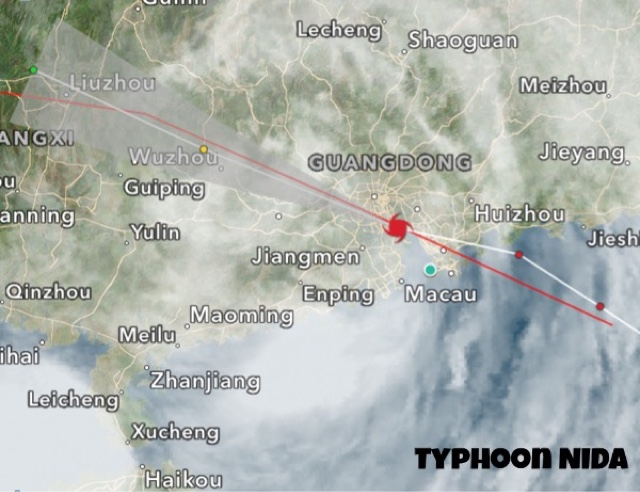
Typhoon NIDA made landfall into China 30 kilometres east of Hong Kong before midnight August 1, 2016 GMT time. Winds at impact were 120 km/h, gusts 150 km/h.

At present it is moving inland into Guangdong province. Though it is weakening, it is still throwing winds of 75 km/h. In the coming couple of days it will weaken further into a low pressure area and bring heavy rains in the province.

Typhoon NIDA landfall China Hong Kong August 2016


Share this PostPin ThisShare on TumblrShare on Google PlusEmail This

Typhoon NIDA Update 4: Heading To Hong Kong, Macau

AUGUST 1, 2016, 1300 GMT

Typhoon NIDA was about 175 kilometres southeast of Hong Kong at 1300 hours GMT, August 1.

Typhoon NIDA rain radar 2016


AUGUST  1, 2016, 0530 GMT

After leaving Philippines, typhoon NIDA has intensified further as it barrels through the South China Sea heading to Hong Kong.

Presently, that is at 0530 hours GMT, the storm is roughly 300 kilometres east of Hong Kong. Sustained winds of 130 km/h, gusts 160 km/h.

Landfall is expected into China, Guangdong province coast 40 kilometres north of Hong Kong at 0000 hours GMT, August 2, 2016, that is after roughly 36 hours.

Wind expected at impact: 130 km/h, gust 160 km/h.

Typhoon NIDA August 1 satellite image


The radar image shows rains have already started in Guangdong as typhoon NIDA approaches.


Share this PostPin ThisShare on TumblrShare on Google PlusEmail This

Update 3: Typhoon NIDA Passing Through Luzon, Target Hong Kong

JULY 31, 2016, 0630 GMT

Tropical cyclone NIDA is presently passing through the northern part of Luzon, Philippines.

Wind speed 110 km/h, gusts 130 km/h. Location is about 400 kilometres north east of Manila.

It will leave Philippines and head into the South China Sea in the next 12 hours. It will intensify as it moves through the sea.

It is expected to hit the Chinese coast at Hong Kong on August 2, 2016 noon local time. Winds expected at impact : 100-110 km/h, gusts 130 km/h.

The European forecast model ECMWF expects landfall a further 100 kilometres north along the Guangdong coast at Danshui and Jhanwei.

Satellite image typhoon NIDA 2016

Rain radar shows heavy precipitation in Luzon as typhoon NIDA passes.

Typhoon NIDA August 2016 update 3

Share this PostPin ThisShare on TumblrShare on Google PlusEmail This

Typhoon NIDA, Update 2: Tropical Depression Now, 650 East of Manila

JULY 30, 2016

Future typhoon NIDA is a tropical depression now. Wind speeds of 50-55 km/h. About 650 kilometres east of Manila. Central minimum pressure:1000 Mb.

The system is intensifying all the time. It will be soon officially named NIDA. The eye of the typhoon will pass close by the northern tip of Luzon on August 1, 2016. Winds of 100-120 km/h will lash northern Luzon when the tropical cyclone passes by. Heavy rains expected in northern Philippines in next 72 hours.

The typhoon will intensify further as it enters the South China Sea. NIDA will make landfall into Guangdong province of China at Hong Kong on August 2, 2016, evening local time. Expected winds at Impact are 130km/h gusts upto 160 km/h.

Typhoon NIDA track forecast update

As typhoon NIDA intensifies, it it is raining in many parts of Philippines, including Manila.


Share this PostPin ThisShare on TumblrShare on Google PlusEmail This

Update 1: Typhoon NIDA To Pass By Luzon July 31, Hit China August 1,2

JULY 29, 2016

Future typhoon NIDA, system 96W in the West Pacific Ocean, lies a few hundred kilometres east of Samar island, Philippines as a depression. Current pressure is 1001 Mb, winds of 35 km/h.

In the next 48 hours it will intensify into a tropical storm and pass by the northern tip of Luzon on Sunday. After that it will move into the South China Sea and intensify rapidly into typhoon NIDA.

It is expected to make landfall into Guangdong province of China between Shanwei and Shantou on August 1-2, 2016.

Different forecast models are giving confusing signals as to the track and intensify of this storm. Some say it will move to Guangdong province of China as a strong typhoon. Others say it will move to Taiwan as a deep depression or a weak cyclone.

Keep in touch for updates.

Typhoon NIDA 2016 depression 96W


Share this PostPin ThisShare on TumblrShare on Google PlusEmail This

Typhoon NIDA Threatens Philippines, China

JULY 25, 2016

After super typhoon NEPARTAK, a weak LUPIT, and the presently brewing tropical cyclone MIRINAE which threatens Hainan and northern Vietnam yet another tropical cyclone is imminent in western Pacific Ocean. NIDA  is likely to affect Luzon in Philippines and mainland China in the coming days.

NIDA  will be born on July 30 as a low pressure area a few hundred kilometres east of central Philippines. It will intensify into a deep depression by the time it moves through Luzon on July 31, 2016. It being at best a deep depression or a weak tropical storm when it passes Philippines, the country will face weak winds of about 60-70 km/h at most. But there will be very heavy precipitation in Luzon.

It will rapidly intensify into a powerful typhoon as it moves through the South China Sea and hit China at Hong Kong or Macau in Guangdong province on August 2-3, 2016.

The European forecast model ECMWF estimates the storm will have a central minimum pressure of 978 hPa. Quite a powerful typhoon. Winds of over 120-130 km/h expected.

It being early days as the storm is yet to be spawned, we will give real time updates as to track and intensity.

UPDATE: JULY 26, 2016

Later data from forecast models say typhoon NIDA may hit China at Zhanjiang in southern Guangdong province that is at an area much further south from Hong Kong. Some models are suggesting a hit on Taiwan. The situation is confusing at present. We shall continue giving you updates. Keep in touch.

UPDATE: JULY 27, 2016
PHILIPPINES STARES AT A TYPHOON (NIDA)

Contrary to earlier forecasts, typhoon NIDA is going to intensify into a tropical cyclone and not a mere depression by the time it reaches Luzon, Philippines, on July 31.

Please keep in touch for latest updates.

JULY 28, 2016

Future typhoon NIDA has been born. It is called 96W. It lies about 350-400 east of Mindanao, Philippines. Central pressure is 1007 Mb. See figure below. In the next 2-3 days it will intensify and move in a NW direction and pass through Luzon on July 31. Latest forecasts say it will hit the Chinese coast at Hong Kong-Macau on August 2-3.
Typhoon NIDA 2016

This latest satellite image shows MIRINAE dissipating after landfall into Vietnam and NIDA growing up east of Philippines.


Share this PostPin ThisShare on TumblrShare on Google PlusEmail This

Typhoon NEPARTAK 2016 Latest Updates

See global oceans latest satellite animated images

JULY 9, 2016: FINAL UPDATE
NEPARTAK WEAKENS FURTHER, ENTERS CHINA

The once mighty super typhoon has weakened into a tropical storm as it entered Fujian province of China. It will further weaken into a low pressure area in the coming days as it moves into Jiangxi and Anhui provinces. Lots of rainfall expected there in the next couple of days.


JULY 8, 2016
TYPHOON MAKES LANDFALL INTO TAIWAN

NEPARTAK weakened to a category 2 hurricane and made landfall into Taiwan at 5:50 AM local time with winds of 191 km/h, gusts upto 234 km/h.

It will hit the Chinese mainland tomorrow as a tropical cyclone. The satellite image of 0650 hours GMT, July 8 shows the eye of the storm has left Taiwan.


JULY 7, 2016
NEPARTAK WILL HIT TAIWAN TOMORROW 

The category 5 hurricane lay about 435 kilometres southeast of Taipei at 0900 hours GMT today. It is expected to hit Taiwan on July 8 as a category 4 storm. As it traverses the country it will rapidly weaken and then make landfall into Fujian province of China on July 9, 2016.

Below is the latest track forecast for NEPARTAK issued by JTWC at 0900 UTC, July 7.


JULY 6, 2016
NEPARTAK A SUPER TYPHOON NOW, TO HIT TAIWAN JULY 8

Contrary to earlier expectations NEPARTAK has intensified rapidly into a super typhoon with winds in excess of 140 knots, 260 km/h. Wind gusts upto an astounding 314 km/h. At 0300 hours GMT July 6 it lay 1135 kilometres southeast of Taipei.

It will weaken after hitting central Taiwan on July 8, 2016, but the country is in for big trouble. The super typhoon is going to rip through the island, then weaken rapidly and enter Fujian province of China on July 9. It will bring heavy rains in Shanghai and South Korea as a depression later on.

The Joint Typhoon Warning Center though believes it will move into Zhenjiang province and Shanghai.


JULY 5, 2016

NEPARTAK is an unpredictable storm. Forecast models are changing their predictions as to where it will go. Latest possibility is that it will skim past the northern tip of Taiwan on July 7, move past Shanghai on July 9 and then curve and pass through South Korea on July 11, weaken and bring heavy precipitation to southern Japan on July 12.

Below is the latest track and intensify forecast. It will be touching sustained wind speeds of 115 knots, 200 km/h when it will pass by northern Taiwan on July 7-8.

Latest forecast is that NEPARTAK will reach peak strength on July 7 with 225 km/h winds. Will move through northern Taiwan on July 7-8, Chinese province of Zhejiang  on July 9.


JULY 4, 2016, TYPHOON NEPARTAK UPDATE 

Latest data suggests NEPARTAK will skip both Taiwan and China but hit Kyushu island of Japan on July 10........

Latest data from numerical forecast models suggest typhoon NEPARTAK is going to be stronger than earlier expected. The JTWC expects it to reach peak wind speeds of 110 knots, that is 195 km/h on July 7 as it barrels through the island of Ishikajnma before hitting northern Taiwan. The JTWC does not expect a direct hit on Taiwan but we think the storm will pass right through northern Taiwan in the early hours (GMT) of July 8.

Another change in our forecast is that NEPARTAK after weakening, drenching Shanghai on July 9 will not go to Korea but pass through the Chinese province of Jiangsu on July 10.

The storm lay 340 kilometres west-south-west of Guam at 0400 hours GMT on July 4, 2016. Sustained winds of 80 km/h, gusting upto 95 km/h.

The latest track forecast for NEPARTAK by JTWC. It does not envisage a direct hit on Taiwan or China. We disagree.


JULY 3, 2016

NEPARTAK is a tropical depression south of Guam presently but within next 12 hours it will have intensified into a tropical cyclone. It will not affect Guam or Philippines.

In the coming days it will move towards Taiwan and move past the northern tip of the country on July 7. Typhoon NEPARTAK is expected to hit the Chinese province of Zhenjiang at Wenzhou on July 8, 2016 with wind speeds of about 150 km/h.

The storm will move through Zhenjiang and emerge into the sea at Shanghai and weaken and enter South Korea as a depression on July 11.

The JTWC, Joint Typhoon Warning Center, predicts the typhoon will be at its strongest on July 7 with sustained winds of 180 km/h.





Share this PostPin ThisShare on TumblrShare on Google PlusEmail This

Typhoon Goni To Hit Kyushu, Japan, South Korea August 25, 2015

SATELLITE IMAGE TYPHOON GONI

Goni is a kid brother of super typhoon Atsani which is barreling north into the Pacific Ocean giving Japan a fright. But tropical cyclone Goni is no midget. It is already a category 4 hurricane if we use American terminology with winds of 105 knots (190 km/h).

It is presently passing by Luzon in Philippines. Heavy rains are reported from northern Philippines with the coast being very windy as the periphery moves by.

On August 22, Goni will pass the eastern coast of Taiwan but at a distance of about 200 kilometers. Even then the effect will be considerable on the eastern parts of the country which will face torrential rains and winds in excess of 120 km/h.

Though typhoon Goni will intensify in the next two days as it passes Taiwan, it will not achieve super typhoon status. But it will then have a central minimum pressure of 913 millibars. A dangerous storm.

As it moves towards Japan after that it will start weakening. It will move through Kyushu, right through Nagasaki. Kyushu and Chukogu districts of Japan will be badly hit.

The weakening storm will then move through South Korea and then into northeast China on August 26, 2015. There will be very heavy rains in South Korea and Hebei, Liaoning provinces of China.

See the storm live at CYCLONE TRACKER

Track forecast typhoon Goni Taiwan South Korea Japan August 2015
TRACK FORECAST AND EXPECTED WIND SPEEDS (IN KNOTS) FOR TYPHOON GONI BY JTWC. THE CYCLONE WILL MOVE THROUGH SOUTHERN JAPAN INTO SOUTH KOREA ON AUGUST 25-26 AFTER WEAKENING.

Share this PostPin ThisShare on TumblrShare on Google PlusEmail This

2 Future Pacific SUPER TYPHOONS Goni, Atsani Threaten China, Japan

The over-active West Pacific Ocean has given birth to typhoons Goni and Atsani which are destined to turn into  super typhoons soon and may threaten Taiwan, China and Japan in a few days this August 2015.


Track forecast Typhoon Goni Atsani West Pacific August 2015
EXPECTED PATH/TRACK FORECAST OF NORTH WEST PACIFIC OCEAN TYPHOONS GONI, ATSANI AUGUST 2015

It is hard to say which of the storms IS going to turn into a bigger cyclone. Typhoon Goni? Typhoon Atsani? Present forecasts say both will become super typhoons soon. That means sustained wind speeds in excess of 130 knots (240+ km/h).

Goni is growing now as it moves over Guam now. It will move in a WNW direction in the coming days. It is not going to touch Philippines. It is safe.

But Taiwan may be in for a bad time in a week's time around August 22, 2015 as Goni, (Will be a howling giant by then) will come visiting. It is possible the storm may move just past the northern coast of Taiwan and go on and hit mainland China at Shanghai on August 24.

The typhoon will have a minimum central pressure of 915 Mb then. That spells bad news for Shanghai. A very big, mean, powerful destructive cyclone.

The other big bad guy in the Pacific, typhoon Atsani will swing north soon, giving Guam a miss and grow into a super typhoon in a couple of days.

Atsani is expected to have a central pressure of 896 Mb! You will recollect the Atlantic super cyclone Wilma had a similar minimum pressure.

As to its future route, it is going to pass Iwo Jima, that is for sure. But after that it may swing dangerously towards central Japan. Whether it hits the country or not at Tokyo is to be seen. Our guess is it will not, but swing away but dangerously close to Tokyo by August 24, 2015.

The two typhoons will have many Asian countries worried in the next few days.

See the storm live at CYCLONE TRACKER

Typhoon Goni typhoon Atsani Pacific ocean august 2015
PRESENT (AUGUST 15, 2015) INFRA RED IMAGE OF THE WEST PACIFIC SHOW THE FLEDGELING TYPHOONS GONI AND ATSANI. IN A FEW DAYS THEY WILL BOTH TURN INTO SUPER TYPHOONS THREATENING CHINA AND JAPAN

Share this PostPin ThisShare on TumblrShare on Google PlusEmail This

Big Typhoon SOUDELOR Weakening Before Hitting China, Goni and Atsani Waiting

Typhoon Soudelor is a massive typhoon and it leaves behind a devastated Taiwan. It has started to weaken and will enter China at Fujian Province just south of Fuzhou August 8, 2015 noon GMT.


satellite image typhoon soudelor molave august 2015
SATELLITE IMAGE OF TYPHOON SOUDELOR AND TROPICAL STORM MOLAVE TAKEN AT 0000 HOURS GMT AUGUST 8, 2015

The tropical cyclone had a central minimum pressure of 915 Mb just before it hit Taiwan. That is a big big bad storm. Winds 0f 200+ kph, gusts upto 250 kph.

And it passed just south of the country's capital Taipei. The city must have been badly affected.

Luckily for China Soudelor is weakening as it prepares to make landfall into mainland China today evening. Ground Zero will be the Fujian coast just south of Fuzhou.

Even a weakening storm as this one will be something to watch out for. Winds of 150+ kph and even more worrying the torrential rain. A weakened cyclone throws down a lot of rain.

Withing the next 24 hours, typhoon Soudelor will shrink into a low pressure area. But it will travel right through north eastern China in the next 2-3 days. One can expect rainfall in the provinces of Jiangxi, Hubei, Anhui, Henan, Jiangsu and southern Shandong. The low pressure area will then move into Korea. Phew!

Soudelor has a lot of energy and moisture and it will traverse quite a distance in China in the next few days bringing floods in many areas.

Meanwhile the other tropical storm in the West Pacific, Molave, is quite harmless in contrast. It will never intensify into anything big and it will not make landfall in any populated landmasses. It will swing away from Japan and move north-easterly harmlessly into the cold North Pacific. A nuisance to shipping lanes perhaps but otherwise a harmless guy.

TYPHOONS GONI AND AFSANI IN THE WAITING

There is bad news for the Philippines. After typhoon Soudelor and tropical storm Molave, the Western Pacific is going to throw out two more typhoons, Goni and Atsani within a week. One of them will probably threaten Philippines around August 25, 2015.

Satellite image typhoon Soudelor Molave august 2015
WESTERN PACIFIC OCEAN SATELLITE IMAGE AUGUST 9, 2015. TYPHOON SOUDELOR HAS ENTERED CHINA AND WEAKENED. MOLAVE IS SWINGING AWAY. WITHIN A WEEK TYPHOONS GONI AND ATSANI WILL BE COMING


Typhoon Soudelor China Fujian Province Taiwan August 2015
TYPHOON SOUDELOR WILL ENTER FUJIAN PROVINCE, CHINA AUGUST 8, 2015 AFTERNOON LOCAL TIME WITH 150 KPH WINDS

Share this PostPin ThisShare on TumblrShare on Google PlusEmail This

Pacific Typhoons Chan-Hom, Linfa, Nangka... Headed Where?

Where will the three West Pacific Ocean typhoons, Chan-hom, Linfa and Nangka go? Opinions differ. But Taiwan and Fujian province of China seem to be in for rough weather.

satellite image tropical cyclone Chan-hom linfa nangka july 6 2015
Satellite image taken at 0900 GMT, July 6, 2015, showing typhoons Chan-hom, Nangka and Linfa


The ocean is over active now, hurtling tropical cyclones and storms by the fistfuls. Let us discuss the forecasts for each of these...

TYPHOON CHAN-HOM

It has moved past Guam Island and if the JTWC is to be believed, it is headed for a super typhoon status soon in a couple of days, that is by July 9, 2015. It is expected to move past Okinawa by Friday morning, a few hundred kilometers away. But since Chan-hom will be so powerful then, expect very stormy weather at Kadena.

After that what? Forecasts differ. The JTWC says it will go onto hit Shanghai head on July 11, 2015. We think it will make landfall into Fujian province in China  just south of Fuzhou. It will weaken before impact on July 11. But it is going to kiss the northern part of Taiwan before that on July 10. Taipei and Chilung will be hit by winds of 250 km/h.

TYPHOON LINFA

Tropical cyclone Linfa is smaller in comparison. It has just passed northern Philippines and is going to intensify as it heads north towards the south-western coast of Taiwan. It will have winds of 60-70 km/h when it kisses the country's coast at Kaohsiung and Tainan on July 10, 2015. It will weaken into a low and head to Fujian in China after that.


TYPHOON NANGKA

This one is in the league of Chan-hom. A possible super typhoon. Luckily it is not going to head to heavily populated land masses. But it is going to move perilously close to the Japanese island of Iwo Jima on July 14, 2015. It is possible it may hit it directly. Predictions differ on the track of Nangka. 

The first possibility is it will kiss Iwo Jima and swing away from the east coast of Japan harmlessly. Another option is it will swing westwards and move right through the southern Japanese islands of Oshima and Okinawa. A dangerous possibility.
Share this PostPin ThisShare on TumblrShare on Google PlusEmail This

FUTURE STORMS: Typhoon"KAMMURI" Will Hit Taiwan And East China In Early October, 2014

XWF FORECAST MAP: October 2, 2014. Typhoon Kammuri gains strength and moves west towards China

The Western Pacific is in ferment. It is churning out typhoons every couple of days. After Kalmaegi, tropical cyclone Fung-wong has already formed (It is a low pressure area now) and will hit Japan on September 21, 2014.

After that Tropical Cyclone KAMMURI will form north east of Philippines as a humble low pressure area on September 27, 2014. It will not go to either Philippines or Japan but will gain momentum, move west pass pelt melt over Taiwan and then slam into the Chinese coast north of Hongkong.


Share this PostPin ThisShare on TumblrShare on Google PlusEmail This

KALMAEGI HITS CHINA, HAINAN ISLANDS: A VIDEO


Share this PostPin ThisShare on TumblrShare on Google PlusEmail This

Latest satellite image of Typhoon Kalmaegi: 0000 hrs September 16, 2014


 KALMAEGI AS IT MOVES IN THE SOUTH CHINA SEA

THE STORM APPRAOCHES HAINAN ISLAND

Share this PostPin ThisShare on TumblrShare on Google PlusEmail This

TYPHOON KALMAEGI UPDATE SEPT. 15, 2014, 0430 HRS GMT. Gaining Strength, Wll Hit China Tomorrow Noon, Vietnam Tomorrow Night

Kalamegi is a fast moving storm. It has moved on from the Philippines and now is gathering power in

 the South China Sea.

Earlier we had said that it would hit the area around Zhanjiang in China; But Kalmaegi seems to have changed its mind. It will hit China further south.The eye of the storm will move between Hainan Island and southern tip of Guangdong province tomorrow (Sept. 16, 2014 Noon, Local Time).

Twelve hours after that, (September 16, 2014 night) it will hit Vietnam at Haiphong.


As for the expected rainfall. Hainan Island of China and Northern Vietnam will see a deluge and consequent flooding.

Satellite Image fo Typhoon KALMAEGI taken at 0300 Hrs, September 15, 2014

 XWF RAIN PREDICTION MAP: Hainan Island will get maximum rainfall from Typhoon Kalmaegi


XWF RAIN PREDICTION MAP: North Vietnam Will See Flooding on September 16-17 owing to KALMAEGI
Share this PostPin ThisShare on TumblrShare on Google PlusEmail This

LATEST KALMAEGI UPDATE: Typhoon Will Hit Philippines With Winds of 160 Kph Today Night

Latest satellite image (0300 Hrs GMT September 14, 2014) of Kalmaegi

Cyclone Kalmaegi approaches North Philippines with howling winds and torrential downpours. It will make landfall tomorrow night (local time), that the night of September 14, 2014. Winds will be in excess of 150 kph. Wave surge will be 10-12 meters or even more. The Batanes islands will be worst hit.

Kalmaegi will weaken as it passes over northern Philippines but will strengthen again as it enters South China Sea. It will hit the southern neck of Guangdong province on September 16, 2014, late night. Worst hit be the city of Zhanjiang which will see winds of 130 kph.

The typhoon will then move along the coastal areas of China in the Gulf of Tonkin and enter the area of border of Vietnam and China on the 17th of September. Though the winds will be less but the rains will be very heavy in North Vietnam.

Latest projected path of Kalmaegi according to JTWC.

 Kalmaegi will strengthen again in the South China Sea. This is the forecasted position of the typhoon on September 16, 0000 hrs GMT.
-----------------------------------------------------

 Northern Philippines coast will see waves surge by 12 meters.
--------------------------------------------

Total rainfall owing to Kalmaegi forecasted from now till September 18, 2014. The white patches show heaviest precipitation.

SIDELIGHTS: THIS LADY TAIWANESE FORECASTER HAS GOT IT RIGHT!

THIS VIETNAMESE WEATHERGIRL WARNS ABOUT KALMAEGI

Share this PostPin ThisShare on TumblrShare on Google PlusEmail This

Latest Forecasts/Updates


Popular Posts

Search This Site