Showing posts with label Nilam. Show all posts
Cyclone NILAM Will Bring Heavy Rains To Southern, Eastern and Parts of Central India.
Cyclone NILAM is powerful. It is a very moisture laden system and its inherent strength is going to being heavy rains to not only Tamil Nadu Eastern Karnataka, Andhra Pradesh but also to Orissa, eastern Maharashtra, West Bengal and parts of Madhya Pradesh in the next week.
![]() |
| Rainfall Prediction Map owing to NIlam. From Oct 31, 2012 to Nov 7, 2012 |
Latest Cyclone NILAM Predicted Path: Target PUDUCHERRY (Pondicherry) 5 PM Wednesday
The latest predictions by the JTWC say that Cyclone NILAM is going to hit the Tamil Nadu coast bang onto Puducherry at Wednesday 5 PM (IST).. So powerful is the storm that it will keep moving inland for another 24 hours with storm strength and reach Bellary in Karnataka when it will dissipate below storm strength.
Cyclone NILAM Will Bring Heavy Rains To Tamil Nadu, Andhra, Orissa And West Bengal
![]() |
| Projected path of NILAM according to JTWC (Joint Typhoon Warning Center) |
| Increasing rainfall |
![]() |
| Rainfall prediction map owing to NILAM. Oct. 31, 2012 to Nov 3, 2012 |
Cyclone Nilam To Hit Chennai Wednesday (October 31, 2012) Evening. VERY HEAVY RAINS IN TN AND AP
![]() |
| Expected path of Cyclone NILAM |
Expected Nilam is still a deep depression, but it will start intensifying and turn into a cyclone by today (Tuesday, 30 Nov. 2012) evening. It will then hit the coast just below Chennai by tomorrow (Wednesday, October 31, 2012) evening.
Nilam will be a moderate storm with wind speeds exceeding 62 KMPH at the least. Though gale winds may touch the 100 KMPH mark. Nothing to sneeze at that.
Lots of rain. It must be raining in Chennai and the rest of Tamil Nadu now. The rains are going to increase all the time. Expect a deluge.
There will be heavy rains in Andhra Pradesh too over the days
| Increasing rainfall |
![]() |
| Rainfall prediction map. Cyclone NILAM. October 30 to November 3, 2012 |
The deep depression over southwest Bay of Bengal remained practically stationary and
lay centred at 0530 hours IST of today, the 30th October, 2012 over southwest Bay of Bengal
near lat. 9.0°N and long. 82.0°E, about 500 Km southsoutheast of Chennai. The system would
intensify further into a cyclonic storm and move northwestwards for some more time and then
cross north Tamilnadu and adjoining south Andhra Pradesh coast between Nagapattinam and
Nellore by 31st October, 2012 afternoon/evening.
![]() |
| Latest image of Cyclone Nilam |
Tropical Storm NILAM To Hit Tamil Nadu On October 31, 2012
It is certain that the deep depression is hovering around in the Bay of Bengal. It is going to intensify further and move towards the Tamil Nadu coast in the next few hours.And hit it on October 31, 2012. The moot point is will it be strong enough to be christened NILAM by the stingy IMD?
Some forecasts say that the system is going to throw gale winds>>> 80-90 KMPH. Now that definitely means a cyclone. It should get the name NILAM. But IMD? Anyway.
| Increasing wind speeds |
![]() |
| Projected Path of Expected Cyclone NILAM (October 29-October 31, 2012) |
The deep depression over southwest Bay of Bengal near latitude 9.50 N and longitude 84.00 E, about 550 km southeast of Chennai (Tamil Nadu) and 300 km east-northeast of Trincomalee (Srilanka) is gong to intensify rapidly and hit the Tamil Nadu coast south of Chennai on October 31, 2012.
Very strong winds and lots of rains. So strong is the system that in the next few days it will move along northward and bring rains (Not only Tamil Nadu) to Andhra Pradesh, Maharashtra, Orissa, Jharkhand and Gangetic West Bengal.
Folks, bad girl NILAM is coming!
Very strong winds and lots of rains. So strong is the system that in the next few days it will move along northward and bring rains (Not only Tamil Nadu) to Andhra Pradesh, Maharashtra, Orissa, Jharkhand and Gangetic West Bengal.
Folks, bad girl NILAM is coming!
| Increasing rainfall |
![]() |
| Rain Prediction Map Oct. 30-Nov 3, 2012 Owing to Expected Cyclone NILAM |
Tags
2012,
bay of bengal,
Chennai,
cylone NIlam,
Nilam,
October,
tamil nadu
Cyclone NILAM May form In The Bay of Bengal: Cross Tamil Nadu Coast Oct. 31, 2012
![]() |
| The Bay of Bengal storm touches the Tamil Nadu coast south of Chennai. October 31, 2012 |
But the scenario is fuzzy right now. The expected storm may or may not be of Cyclone strength (May not be christened NILAM). It may turn out to be just a depression, deep or otherwise.
And as a result, lots of rains expected in Tamil Nadu and Andhra Pradesh on October 30-31, 2012
![]() |
| Rain prediction map. Lots of rain in Tamil Nadu on October 31, 2012 |
THE AREA OF CONVECTION PREVIOUSLY LOCATED NEAR 10.6N 86.8E IS NOW LOCATED NEAR 9.7N 84.9E, APPROXIMATELY 345 NM EAST-NORTHEAST OF COLOMBO, SRI LANKA.
NUMERICAL MODEL AND INTENSITY GUIDANCE DEVELOPS THIS SYSTEM TO MINIMAL TROPICAL STORM STRENGTH OVER THE NEXT 24-36 HOURS AS THE STRONGER WINDS BEGIN TO WRAP AROUND THE LLCC.
THE POTENTIAL FOR THE DEVELOPMENT OF A SIGNIFICANT TROPICAL CYCLONE WITHIN THE NEXT 24 HOURS IS HIGH.
WHAT THE INDIAN MET DEPT SAY (TODAY OCTOBER 28, 2012, 5:30 AM)
The low pressure area over southeast Bay of Bengal and neighbourhood now lies as a well marked low pressure area over central parts of south Bay of Bengal and neighbourhood. The associated upper air cyclonic circulation extends upto 3.1 Km above mean sea level. The system may concentrate into a depression during next 24 hours.
Latest Cyclone NILAM Predicition: Nov. 3, 2012: Target Kutch!
![]() |
| Novemeber 3, 2012. Cyclone NILAM hits the Gujarat coast |
NILAM is going to be big. May be a super cyclone. (See the image below). It is going to hit the Gujarat coast in Kutch district on November 3rd, 2012.
![]() |
| Projected path of Cyclone NILAM. October 30, 2012 to November 3, 2012 |
So big the storm is going to be that the entire western region of India; the states of Gujarat, Rajasthan and coastal Maharashtra are going to receive rains. The most drenching is reserved for Kutch in Gujarat and Rajasthan.
So massive and strong is tha system that it may move inwards into India cut across Rajasthan and give rains to Delhi and Uttaranchal too! All these states will get massive rains till the 5th of November., 2012.
![]() |
| Rainfall Prediction Map: Cyclone NILAM: October 31, 2012 to November 4, 2012. |
Tags
2012,
arabian sea,
cyclone,
gujarat,
Nilam,
November,
super cyclone
Massive Arabian Sea Cyclone NILAM To Hit Gujarat On November 3, 2012
![]() |
| Expected Cyclone NILAM on November 2, 2012 between Oman and Gujarat |
![]() |
| Cyclone MURJAN made landfall on November 25, 2012 at the Horn of Africa. |
![]() |
| NILAM takes birth. Oct. 29, 2012 |
In the next few days it will start moving in a general northerly direction gaining strength all the time and turn into a massive cyclone. On the 2nd of November it will reach the seas between the Gujarat and Oman coast. Present forecasts say it will then tilt eastwards and hit the Gujarat coast near Dwarka on November 3, 2012,
It is early days now. So there are equal chances that Nilam may hit Oman, Pakistan or Gujarat.
One thing is certain. Big Cyclone NILAM is coming.
Keep reading this site for the latest info.
![]() |
| Projected Path of Cyclone NILAM. Wind Speeds. October 29 to November 3, 2012 |
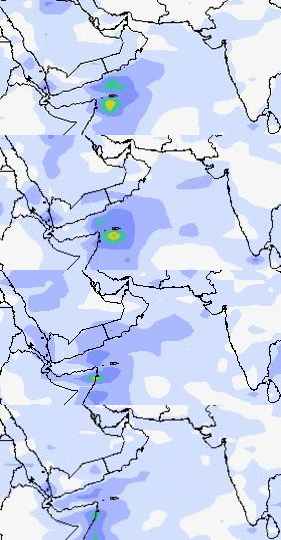
Arabian Sea Claims MURJAN, Will Claim Cyclone NILAM Too!
Strange this year. Two cyclones in the North Indian Ocean in October, November 2012. Both in the Arabian Sea. And both expected to hit Somalia (Or at least affect)!
The first MURJAN is likely to enter Somalia today itself.
The second cyclone, NILAM, will form on the 31st of October, 2012 off the coat of Somalia. It will intensify and touch the Horn of Africa on November 3 and then move northerly and make landfall on the Oman-Yemen border on November 5.
Folks in Oman! The remnants of NILAM will drift upwards towards entire Oman and the country may receive some showers around November 8, 2012. No heavy falls. But some rains possible.
As for the Bay of Bengal a system will try to form on October 28 off the coast of Visakhapatnam. But it will not gain much strength. Not even a low pressure. But there will be rains on the Tamil Nadu and North Andhra coast. These areas any way get rains now because it is the North East Monsoon season. But no significant storms likely in the future.
The first MURJAN is likely to enter Somalia today itself.
![]() |
| Cyclone MURJAN will enter Somalia today |
The second cyclone, NILAM, will form on the 31st of October, 2012 off the coat of Somalia. It will intensify and touch the Horn of Africa on November 3 and then move northerly and make landfall on the Oman-Yemen border on November 5.
Folks in Oman! The remnants of NILAM will drift upwards towards entire Oman and the country may receive some showers around November 8, 2012. No heavy falls. But some rains possible.
![]() |
| Wind speed map. Predicted path of cyclone NILAM. Nov 1-Nov 5, 2012 |
Tags
2012,
arabian sea,
bay of bengal,
cyclone,
Murjan,
Nilam,
North Indian Ocean,
November,
October
Subscribe to:
Posts (Atom)
Latest Forecasts/Updates
Popular Posts
-
Cyclone Nanauk about to hit the south Oman coast on June 3, 2014 BREAKING FORECAST....... THE US NAVY METEOROLOGISTS PREDICT A M...
-
NASA in its postmortem of Cyclone Nanauk says it was a powerful cyclone throwing up storms 16 kms high in the atmosphere. Tropical...
-
UPDATE MAY 16, 2015: DOLPHIN A SUPER TYPHOON NOW Typhoon Dolphin in a few hours will turn into a howling super typhoon with winds of a st...
-
Now it is becoming increasing clear that the tropical storm which is likely to form over the Arabian Sea south of the Saurashtra (India) coa...
-
Weather Prediction map. October 30, 2012. Wind speed map. Red color is real bad news. Winds excess of 70 Kmph It is October and time f...
-
MAY 9, 2017, TUESDAY Hopes of an early arrival of southwest monsoon this year may be belied. Latest forecast by the sensitive CFS model...
-
MAY 22, 2016 ROANU NOW A DEPRESSION, OVER MYANMAR Cyclone Roanu is a cyclone no more. It weakened to a deep depression and then into a d...
-
Update: December 10, 2014 The system (96W) that has formed in the Pacific near Palau Island will not intensify into a significant tro...
-
A low pressure area is being born now As I write these words a churning in the great mass of rain clouds in south Arabian Sea has begu...
-
INFRA-RED IMAGE OF MAHASEN TODAY (12.00 NOON, IST) MAY 16, 2013 "MAHASEN" NEARS CHITTAGONG! WILL HIT TODAY EVENING. IT IS ...


