Showing posts with label Murjan. Show all posts

Arabian Sea Claims MURJAN, Will Claim Cyclone NILAM Too!

Strange this year. Two cyclones in the North Indian Ocean in October, November 2012. Both in the Arabian Sea. And both expected to hit Somalia (Or at least affect)!

The first MURJAN is likely to enter Somalia today itself.
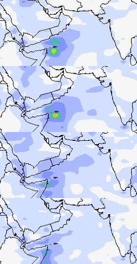
Cyclone MURJAN will enter Somalia today

The second cyclone, NILAM, will form on the 31st of October, 2012 off the coat of Somalia. It will intensify and touch the Horn of Africa on November 3 and then move northerly and make landfall on the Oman-Yemen border on November 5.

Folks in Oman! The remnants of NILAM will drift upwards towards entire Oman and the country may receive some showers around November 8, 2012. No heavy falls. But some rains possible.

Wind speed map. Predicted path of cyclone NILAM. Nov 1-Nov 5, 2012
As for the Bay of Bengal a system will try to form on October 28 off the coast of Visakhapatnam. But it will not gain much strength. Not even a low pressure. But there will be rains on the Tamil Nadu and North Andhra coast. These areas any way get rains now because it is the North East Monsoon season. But no significant storms likely in the future.
Share this PostPin ThisShare on TumblrShare on Google PlusEmail This

No Murjan, Just A Depression In Bay Of Bengal, Nov. 2012?

Ah! The vagaries of nature! Unpredictable nature!

Latest forecasts say that the Bay of Bengal storm expected to form in the end of October, 2012 will be below cyclone strength. So it will not be honored with the name Murjan.

The expected system will turn into a low pressure area on October 31, 2012. It will initially move towards Orissa, but them abruptly start moving eastwards towards the Myanmar. As it does it will gain strength and turn into a depression and hit the Burmese coast on Nov. 3, 2012.

Projected path (showing wind speed) of the Bay of Bengal rain system. 31 Oct.-3 Nov. 2012
RAINFALL PREDICTION FROM THE BAY OF BENGAL DEPRESSION OCT-NOV 2012

The Indian states of Orissa and northern Andhra Pradesh will receive some rain on October 31, 2012 as the low pressure area initially moves towards the Indian coast.

But Myanmar is going to receive very heavy rainfall on November 3-4, 2012.A real drenching. A natural tragedy awaits Myanmar.

Rain prediction map. Bay of Bengal depression  October 31-November 4, 2012
Last few words. It is still ten more days to go. Who the hell can say where the storm will go? The coastal areas of Bay of Bengal will have to be on their toes in the next ten days. India, Bangladesh and Myanmar? Where?

Share this PostPin ThisShare on TumblrShare on Google PlusEmail This

Expected Bay Of Bengal Cyclone MURJAN Will Hit Orissa On October 29, 2012


Cyclone Murjan will hit Orissa on October 28, 2012

We had predicted earlier that the expected tropical cyclone Murjan which is going to form in the Bay of Bengal (North Indian Ocean) will touch the Orisaa coast and then move into West Bengal.

Well, Murjan seems to have changed its mind. It is going to shower its "affections" only on Orissa. It is expected to hit the coast  at Gopalpur-in-sea on October 28, 2012 and drench the state in the next two days.


Point of impact. Murjan will hit the Orissa coat at Gopal-on-sea on October 28, 2012

Murjan is going to be a big nasty storm. High winds. Heavy rains. Super cyclone? May be.

It is time the Orissa government (I am sure they already are) start preparing for the worst. Murjan is going to be big bad boy.

Predicted path of cyclone "Murjan". October 26, 2012 to Oct. 28, 2012

Share this PostPin ThisShare on TumblrShare on Google PlusEmail This

Big Cyclone MURJAN Likely To Hit Indian East Coast On October 30, 2012

Weather Prediction map. October 30, 2012. Wind speed map. Red color is real bad news. Winds excess of 70 Kmph

It is October and time for the North Indian Ocean to churn up big destructive tropical cyclones. Well, this year is going to be no different. The Arabian Sea is going to spawn a low pressure area but it will move towards the Horn of Africa skipping its usual haunts, Gujarat and Oman.

But the main prediction is the big bad storm that the Bay of Bengal is going to engender. The birth place of the cyclone is going to be east of the Andaman and Nicobar Islands.On the 26th of October, 2012.


Rain prediction amp. October 27, 2012. Andaman, Nicobar Islands getting a drenching. Color pink means deluge.

After drenching the Andaman islands on the 27th the storm will rapidly gain strength and move north-westwards and reach the coast on the Orissa-Andhra Pradesh border on October 30, 2012.

Prediction now say it will then start losing steam and start moving along the coast in a north-easterly direction and make landfall on the Bangladesh-North East Indian border on October 31, 2012.

The places to get a real drenching? Andaman and Nicobar Islands, Northern Andhra Pradesh coastal areas, Orissa, Bangladesh coast and India's north-eastern states of Manipur, Mizoram, Tripura and parts of Assam. West Bengal, Bangladesh and the north eastern Indian states mentioned will receive rainfall till the 2nd of November.

Rain prediction map. October 31, 2012. The storm moves to make landfall. Light blue color means heavy rains
The scenario we have outlined is based on current forecasts. Cyclones are by nature very unpredictable so the expected storm may hit anywhere on the Bay of Bengal coast in Indian and Bangladesh.

Also we are now saying that the storm will weaken before it makes landfall. This too is hard to say with conviction.

One thing is certain. A big cyclone is going to form in the Bay of Bengal in the next ten days. The governments of India and Bangladesh will have to watch the seas closely in the next few days.

Rain prediction map. October 30, 2012. The storm drenching coastal Andhra Pradesh and Orissa.
UPDATE: OCTOBER 21, 2012, O6.54 UTC

Latest forecasts say that the storm is going to hit the Orissa coast on the 29th of October, 2012. It will them move into West Bengal and traverse the state moving northwards.Heavy rains throughout West Bengal (October 30, 2012), North Bengal, Sikkim and eastern Nepal on the 31st October, 2012. Orissa coast is in for strong gale and heavy downpour on the 29th of October.


Rain prediction map. Oct. 29 to Oct. 31, 2012. Cyclone Murjan


Share this PostPin ThisShare on TumblrShare on Google PlusEmail This

"Murjan" Coming? Tropical Storm Brewing in Bay Of Bengal: To Move To Indian Coast In Few Days

WEATHER FORECAST MAP: The storm will hit the Andhra coast on April 25, 2012

The weather gods seem to be in a hurry this year. It is April only and yet a tropical storm is likely to hit the eastern coast of India in the next few days bringing heavy rains and strong winds.

The storm is expected to hit the Indian coast between Visakhapatnam and Rajahmundry on April 25, 2012 (Wednesday) with cyclone strength. The coastal areas of Tamil Nadu and and then Andhra Pradesh will start receiving heavy rains from April 24 itself as the storm starts nearing the Indian land mass. The storm will then move along the coast northwards and strengthen all the time. The heavy winds will really start once it reaches the Visakhapatnam-Rajahmundy belt.


WEATHER FORECAST MAP: High winds and heavy rains on April 25, 2012

The expected storm is germinating in the cloud mass that lies presently about 600 Kms east of the Sri Lankan coast (Latitude: 85 degrees east, Longitude: 6 Degrees north). It will slowly intensify and start moving towards the Indian east coast. It will come  near Puducherry and Chennai which will start getting a drenching from Monday, April 23, 2012 noon (local time).

WEATHER FORECAST MAP: Birth of the storm. See the yellow and green mass east of Sri Lanka?

The system will then start moving north. As a result coastal areas of Tamil Nadu and Andhra Pradesh will get heavy rains too. The worst affected will be as said before Guntur-Rajahmundy-Visakhapatanm (April 25). By then the wind speeds will be in excess of 70 Kmph. A cyclone in other words.

The system will move along the coast passing through Orissa (April 26, 2012), Gangetic West Bengal (April 27, 2012) and then Bangladesh (April 27, 2012).

WEATHER FORECAST MAP: Storm hits Orissa. April 26, 2012

The storm is going to reach cyclone strength once it reaches the Rajahmundry area in Andhra Pradesh. That is winds in excess of 64 Kmph. And move with great vigour till it reaches Bangladesh on April 27. After which it will dissipate.

Words of warning. Very strong winds and very heavy rainfall expected from April 25 to April 27. In north coastal Andhra Pradesh, Orissa, Gangetic West Bengal and Bangladesh.

WEATHER FORECAST MAP: It is Gangetic West Bengal and Bangladesh on April 27, 2012

This is going to be a cyclone. A small one albeit. Wonder if the IMD will christen it "Murjan".


Satellite image: April 20, 2012
Share this PostPin ThisShare on TumblrShare on Google PlusEmail This

Latest Forecasts/Updates


Popular Posts

Search This Site