Showing posts with label LIONROCK. Show all posts

Typhoon LIONROCK Japan Rendezvous OnWednesday

Typhoon LIONROCK August 27 north west Pacific Ocean

AUGUST 27, 2016, SATURDAY 

Latest forecasts hint that the presently category 3 typhoon LIONROCK in north west Pacific Ocean may make landfall into Japan on August 31, Wednesday instead of Tuesday as earlier expected. The target area is northern part of Honshu island, between Iwaki and Shiroishi. The storm may pass perilously close to Fukushima. Tokyo seems to be saved from a direct hit. The typhoon will make landfall about 150 kilometres north of the city. 

At 0000 hours GMT today the cyclone lay about 525 kilometres roughly east of Naha, Okinawa. Direction is north east. Current sustained wind speed is 180 km/h, gusts upto 210 km/h. It was moving at about 9.2 km/h.   It will slowly weaken as it curves towards Japan. 

The JTWC believes it will be a mere tropical storm at the time of impact with 100 km/h winds. It also foresees a landfall at a spot even further north into Honshu (near Morioka and Kitikami) than what we predict. Our estimate is LIONROCK will pack quite a punch at landfall with winds of about 150 km/h.    

Share this PostPin ThisShare on TumblrShare on Google PlusEmail This

Category 3 Typhoon LIONROCK May Hit Tokyo, Central Japan August 30, 2016

Typhoon LIONROCK west Pacific Ocean Japan August 2016

AUGUST 25, 2016, THURSDAY 

Intensifying typhoon LIONROCK is hovering in north west Pacific Ocean presently just a few hundred kilometres from Okinawa. 

Unlike most west Pacific Ocean tropical cyclones this one did not emerge from lower latitudes in the sea east of Philippines but came from North Pacific.

Forecast models seem divided as to where the storm will go. 

In the next couple of days it will retract its steps and strengthen further. Our estimate is by Saturday-Sunday it will be a category 4 hurricane with sustained winds of 240 km/h.

It will then weaken a little and slam into central Japan near Tokyo on Tuesday, August 30, 2016 with winds in excess of 200 km/h.

Worrisome for people of Japan.

0000 hours GMT, August 25, 2016

POSITION: About 900 kilometres roughly east of Taipei 

WIND SPEED:  Sustained- 200 km/h, Gusts- 240 km/h
Share this PostPin ThisShare on TumblrShare on Google PlusEmail This

Super Typhoon LIONROCK May Hit Japan On August 29, 2016

AUGUST 23, 2016, TUESDAY

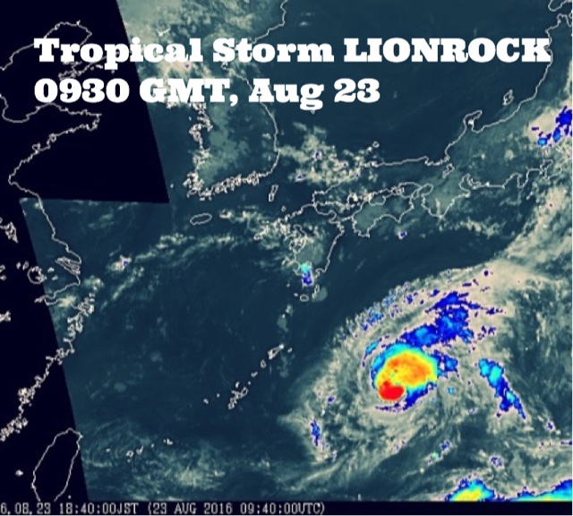
Tropical storm LIONROCK has already formed. At present it lies about 650 kilometres northeast of Naha, Okinawa in Northwest Pacific Ocean. It already has sustained winds of over 100 km/h. In the coming days it will move a little in the direction of Taiwan then abruptly backtrack.

By Friday it will intensified into a powerful storm. Forecast models indicate the by Sunday it will have a central minimum pressure of an astounding 915 hPa. According to research by American meteorologists with such low pressure in its eye, the tropical cyclone will be throwing winds of about 130-140 knots. That is a category 5 hurricane.

The worrisome aspect is reliable numerical forecast models say super typhoon LIONROCK may hit either southern or central Japan on August 29, 2016. If this does happen it may cause considerable destruction in the country.

The little blessing is the storm is expected to weaken before landfall into Japan.

Tropical storm LIONROCK west Pacific Ocean August 2016
Share this PostPin ThisShare on TumblrShare on Google PlusEmail This

Latest Forecasts/Updates


Popular Posts

Search This Site