Showing posts with label NIDA. Show all posts

Update 5: Typhoon NIDA Makes Landfall Near Hong Kong

AUGUST 2, 2016

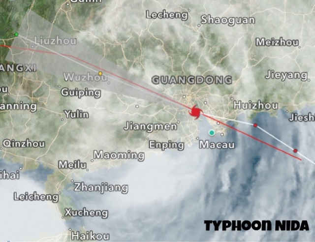
Typhoon NIDA made landfall into China 30 kilometres east of Hong Kong before midnight August 1, 2016 GMT time. Winds at impact were 120 km/h, gusts 150 km/h.

At present it is moving inland into Guangdong province. Though it is weakening, it is still throwing winds of 75 km/h. In the coming couple of days it will weaken further into a low pressure area and bring heavy rains in the province.

Typhoon NIDA landfall China Hong Kong August 2016


Share this PostPin ThisShare on TumblrShare on Google PlusEmail This

Typhoon NIDA Update 4: Heading To Hong Kong, Macau

AUGUST 1, 2016, 1300 GMT

Typhoon NIDA was about 175 kilometres southeast of Hong Kong at 1300 hours GMT, August 1.

Typhoon NIDA rain radar 2016


AUGUST  1, 2016, 0530 GMT

After leaving Philippines, typhoon NIDA has intensified further as it barrels through the South China Sea heading to Hong Kong.

Presently, that is at 0530 hours GMT, the storm is roughly 300 kilometres east of Hong Kong. Sustained winds of 130 km/h, gusts 160 km/h.

Landfall is expected into China, Guangdong province coast 40 kilometres north of Hong Kong at 0000 hours GMT, August 2, 2016, that is after roughly 36 hours.

Wind expected at impact: 130 km/h, gust 160 km/h.

Typhoon NIDA August 1 satellite image


The radar image shows rains have already started in Guangdong as typhoon NIDA approaches.


Share this PostPin ThisShare on TumblrShare on Google PlusEmail This

Update 3: Typhoon NIDA Passing Through Luzon, Target Hong Kong

JULY 31, 2016, 0630 GMT

Tropical cyclone NIDA is presently passing through the northern part of Luzon, Philippines.

Wind speed 110 km/h, gusts 130 km/h. Location is about 400 kilometres north east of Manila.

It will leave Philippines and head into the South China Sea in the next 12 hours. It will intensify as it moves through the sea.

It is expected to hit the Chinese coast at Hong Kong on August 2, 2016 noon local time. Winds expected at impact : 100-110 km/h, gusts 130 km/h.

The European forecast model ECMWF expects landfall a further 100 kilometres north along the Guangdong coast at Danshui and Jhanwei.

Satellite image typhoon NIDA 2016

Rain radar shows heavy precipitation in Luzon as typhoon NIDA passes.

Typhoon NIDA August 2016 update 3

Share this PostPin ThisShare on TumblrShare on Google PlusEmail This

Typhoon NIDA, Update 2: Tropical Depression Now, 650 East of Manila

JULY 30, 2016

Future typhoon NIDA is a tropical depression now. Wind speeds of 50-55 km/h. About 650 kilometres east of Manila. Central minimum pressure:1000 Mb.

The system is intensifying all the time. It will be soon officially named NIDA. The eye of the typhoon will pass close by the northern tip of Luzon on August 1, 2016. Winds of 100-120 km/h will lash northern Luzon when the tropical cyclone passes by. Heavy rains expected in northern Philippines in next 72 hours.

The typhoon will intensify further as it enters the South China Sea. NIDA will make landfall into Guangdong province of China at Hong Kong on August 2, 2016, evening local time. Expected winds at Impact are 130km/h gusts upto 160 km/h.

Typhoon NIDA track forecast update

As typhoon NIDA intensifies, it it is raining in many parts of Philippines, including Manila.


Share this PostPin ThisShare on TumblrShare on Google PlusEmail This

Update 1: Typhoon NIDA To Pass By Luzon July 31, Hit China August 1,2

JULY 29, 2016

Future typhoon NIDA, system 96W in the West Pacific Ocean, lies a few hundred kilometres east of Samar island, Philippines as a depression. Current pressure is 1001 Mb, winds of 35 km/h.

In the next 48 hours it will intensify into a tropical storm and pass by the northern tip of Luzon on Sunday. After that it will move into the South China Sea and intensify rapidly into typhoon NIDA.

It is expected to make landfall into Guangdong province of China between Shanwei and Shantou on August 1-2, 2016.

Different forecast models are giving confusing signals as to the track and intensify of this storm. Some say it will move to Guangdong province of China as a strong typhoon. Others say it will move to Taiwan as a deep depression or a weak cyclone.

Keep in touch for updates.

Typhoon NIDA 2016 depression 96W


Share this PostPin ThisShare on TumblrShare on Google PlusEmail This

Typhoon NIDA Threatens Philippines, China

JULY 25, 2016

After super typhoon NEPARTAK, a weak LUPIT, and the presently brewing tropical cyclone MIRINAE which threatens Hainan and northern Vietnam yet another tropical cyclone is imminent in western Pacific Ocean. NIDA  is likely to affect Luzon in Philippines and mainland China in the coming days.

NIDA  will be born on July 30 as a low pressure area a few hundred kilometres east of central Philippines. It will intensify into a deep depression by the time it moves through Luzon on July 31, 2016. It being at best a deep depression or a weak tropical storm when it passes Philippines, the country will face weak winds of about 60-70 km/h at most. But there will be very heavy precipitation in Luzon.

It will rapidly intensify into a powerful typhoon as it moves through the South China Sea and hit China at Hong Kong or Macau in Guangdong province on August 2-3, 2016.

The European forecast model ECMWF estimates the storm will have a central minimum pressure of 978 hPa. Quite a powerful typhoon. Winds of over 120-130 km/h expected.

It being early days as the storm is yet to be spawned, we will give real time updates as to track and intensity.

UPDATE: JULY 26, 2016

Later data from forecast models say typhoon NIDA may hit China at Zhanjiang in southern Guangdong province that is at an area much further south from Hong Kong. Some models are suggesting a hit on Taiwan. The situation is confusing at present. We shall continue giving you updates. Keep in touch.

UPDATE: JULY 27, 2016
PHILIPPINES STARES AT A TYPHOON (NIDA)

Contrary to earlier forecasts, typhoon NIDA is going to intensify into a tropical cyclone and not a mere depression by the time it reaches Luzon, Philippines, on July 31.

Please keep in touch for latest updates.

JULY 28, 2016

Future typhoon NIDA has been born. It is called 96W. It lies about 350-400 east of Mindanao, Philippines. Central pressure is 1007 Mb. See figure below. In the next 2-3 days it will intensify and move in a NW direction and pass through Luzon on July 31. Latest forecasts say it will hit the Chinese coast at Hong Kong-Macau on August 2-3.
Typhoon NIDA 2016

This latest satellite image shows MIRINAE dissipating after landfall into Vietnam and NIDA growing up east of Philippines.

Share this PostPin ThisShare on TumblrShare on Google PlusEmail This

Latest Forecasts/Updates


Popular Posts

Search This Site