Showing posts with label November. Show all posts

Latest Cyclone NILAM Predicition: Nov. 3, 2012: Target Kutch!

Novemeber 3, 2012. Cyclone NILAM hits the Gujarat coast
Latest predictions of Expected Cyclone NILAM say that the Target is going to be Kutch area in Gujarat. The latest predictions vary little from our yesterday's analysis.

NILAM is going to be big. May be a super cyclone. (See the image below). It is going to hit the Gujarat coast in Kutch district on November 3rd, 2012.


Projected path of Cyclone NILAM. October 30, 2012 to November 3, 2012

So big the storm is going to be that the entire western region of India; the states of Gujarat, Rajasthan and coastal Maharashtra are going to receive rains. The most drenching is reserved for Kutch in Gujarat and Rajasthan. 

So massive and strong is tha system that it may move inwards into India cut across Rajasthan and give rains to Delhi and Uttaranchal too! All these states will get massive rains till the 5th of November., 2012.

Rainfall Prediction Map: Cyclone NILAM: October 31, 2012 to November 4, 2012.

Share this PostPin ThisShare on TumblrShare on Google PlusEmail This

Massive Arabian Sea Cyclone NILAM To Hit Gujarat On November 3, 2012

Expected Cyclone NILAM on November 2, 2012 between Oman and Gujarat
Predicted Cyclone Nilam seems to have changed its mind. We had said yesterday that it was likely to hit the Oman-Yemen border on November 5, 2012. But the lady now seems in a mind to shower its affection on Gujarat.

Cyclone MURJAN made landfall on November 25, 2012 at the Horn of Africa.
NILAM takes birth. Oct. 29, 2012
Nilam is likely to form on October 29, 2012 in the Indian Ocean (68 degrees East, 5 degrees South) about 1200 miles South West of Colombo.

In the next few days it will start moving in a general northerly direction gaining strength all the time and turn into a massive cyclone. On the 2nd of November it will reach the seas between the Gujarat and Oman coast. Present forecasts say it will then tilt eastwards and hit the Gujarat coast near Dwarka on November 3, 2012,

It is early days now. So there are equal chances that Nilam may hit Oman, Pakistan or Gujarat.

One thing is certain. Big Cyclone NILAM is coming.

Keep reading this site for the latest info.

Projected Path of Cyclone NILAM. Wind Speeds. October 29 to November 3, 2012
Share this PostPin ThisShare on TumblrShare on Google PlusEmail This

Arabian Sea Claims MURJAN, Will Claim Cyclone NILAM Too!

Strange this year. Two cyclones in the North Indian Ocean in October, November 2012. Both in the Arabian Sea. And both expected to hit Somalia (Or at least affect)!

The first MURJAN is likely to enter Somalia today itself.

Cyclone MURJAN will enter Somalia today

The second cyclone, NILAM, will form on the 31st of October, 2012 off the coat of Somalia. It will intensify and touch the Horn of Africa on November 3 and then move northerly and make landfall on the Oman-Yemen border on November 5.

Folks in Oman! The remnants of NILAM will drift upwards towards entire Oman and the country may receive some showers around November 8, 2012. No heavy falls. But some rains possible.

Wind speed map. Predicted path of cyclone NILAM. Nov 1-Nov 5, 2012
As for the Bay of Bengal a system will try to form on October 28 off the coast of Visakhapatnam. But it will not gain much strength. Not even a low pressure. But there will be rains on the Tamil Nadu and North Andhra coast. These areas any way get rains now because it is the North East Monsoon season. But no significant storms likely in the future.
Share this PostPin ThisShare on TumblrShare on Google PlusEmail This

No Murjan, Just A Depression In Bay Of Bengal, Nov. 2012?

Ah! The vagaries of nature! Unpredictable nature!

Latest forecasts say that the Bay of Bengal storm expected to form in the end of October, 2012 will be below cyclone strength. So it will not be honored with the name Murjan.

The expected system will turn into a low pressure area on October 31, 2012. It will initially move towards Orissa, but them abruptly start moving eastwards towards the Myanmar. As it does it will gain strength and turn into a depression and hit the Burmese coast on Nov. 3, 2012.

Projected path (showing wind speed) of the Bay of Bengal rain system. 31 Oct.-3 Nov. 2012
RAINFALL PREDICTION FROM THE BAY OF BENGAL DEPRESSION OCT-NOV 2012

The Indian states of Orissa and northern Andhra Pradesh will receive some rain on October 31, 2012 as the low pressure area initially moves towards the Indian coast.

But Myanmar is going to receive very heavy rainfall on November 3-4, 2012.A real drenching. A natural tragedy awaits Myanmar.

Rain prediction map. Bay of Bengal depression  October 31-November 4, 2012
Last few words. It is still ten more days to go. Who the hell can say where the storm will go? The coastal areas of Bay of Bengal will have to be on their toes in the next ten days. India, Bangladesh and Myanmar? Where?

Share this PostPin ThisShare on TumblrShare on Google PlusEmail This

Rains To Continue In Oman

The remains of KEILA will bring more rains in southern Oman for the next 2-3 days.

Cyclone Keila has given a lot of rainfall to Oman in the last few days. Now Keila is no more. It is just a low pressure area now near Salalah in southern Oman. But it is going to give heavy rains in the area (Salalah, Raysut, Thamarit, Mudhay and Sadh) in the next 3 days till Sunday (Nov 6, 2011) The system will then move into Yemen and break-up completely and drift northwards bringing rains to UAE and Qatar.


The whole of Oman is expected to receive some precipitation for at least a week. Especially the coastal areas in the Arabian Sea. Then later another little wet spell around Nov 13, 2011 as the remnants of the low pressure area (which is likely to form on Nov 6, 2011 and move to the waters near the coasts of Oman, Pakistan and Gujarat) drift into Oman.


Nov 13, 2011. Remains of the Arabian Sea Low Pressure will drift into Oman and bring it more rains.
Share this PostPin ThisShare on TumblrShare on Google PlusEmail This

Qatar And UAE In For Rains Shortly Thanks To A Dead Keila

Keila is bringing rains to unexpected places. It has drenched Oman in the last few days (And will bring some more rain for a few more days). Now as it starts breaking up, Qatar and UAE are in for some sharp showers. Qatar first. The rains will start by Sunday evening (Nov 6, 2011) and will continue for 24 hours. The heaviest falls will be on Sunday night.


UAE (Abu Dhabi). The rains will start Monday early morning (Nov 7, 2011) and increase gradually. They will taper off by Tuesday night. It is going to be a very wet Monday in Abu Dhabi.


Rain Prediction Maps

 Rains in Qatar (see the white arrow) on Nov6, 2011 Sunday

Rains arrive in UAE and Abu Dhabi on Monday (Nov 7, 2011) night
Share this PostPin ThisShare on TumblrShare on Google PlusEmail This

Latest Forecast Says Nov 6 Arabian Sea Storm To Be A Mere Low Pressure Area


Slightly dampening news. The expected Arabian Sea storm to be formed on Nov 6, 2011 is not going to be full-blooded cyclone (Nor a Depression). It will be a low pressure system.

The storm will form as said earlier in the Arabian Sea about 1000 Kms NW of Maldives. It will generally move towards the seas between Oman, Pakistan and Gujarat. It will reach there on Nov 10, 2011.

There will be a lot of rains in the sea and then the system will disintegrate around Nov 11, 2011. Some substantial precipitation in Sindh and Gujarat on Nov 11, 12. The remains will drift to Oman and give it some rainfall on Nov 13, 14, 15.

 Nov 6, 2011. The low pressure system is born

 Nov 8, 2011 The storm system moves north towards the seas near Oman, Pakistan and Gujarat

Nov 10, 2011. The low pressure kisses the Omani coast

 RAIN PREDICTION MAP NOV 11, 2011

Nov 11, 2011. Rainfall forecast map. Look at the amount of rains! The system then starts to fizzle out giving some good rains to Sindh and Gujarat


Share this PostPin ThisShare on TumblrShare on Google PlusEmail This

New Big Depression To Form In Arabian Sea Nov 6, 2011

 Wind speed forecast map. The expected depression will cover a large area. A big storm. Seen at its full power on Nov 9, 2011

While the short lived Keila slinks away to Yemen, a new big storm will take birth in the Arabian Sea on Nov 6, 2011. It will not be of cyclone strength; a depression or may be a deep depression. But the remarkable thing is it is going to be depression covering a large area. A big one in short.

As said earlier it will move to the seas between the Omani and Gujarat coast till November 9, 2011. But then it will start breaking up on the 10th of November.Heavy rainfall will lash Pakistani coast on Nov 11, 2011. Gujarat will too get some rains on Nov 13.  as the remnants of the depression will drift towards the state.
Rain forecast map. Sindh and Balochistan coastal areas are in for flooding on Nov 11, 2011

Rain prediction map. Nov 8, 2011. The depression will throw a lot of rain into the Arabian Sea. The purple color means a deluge
Share this PostPin ThisShare on TumblrShare on Google PlusEmail This

Oman In For Rains Thanks To Little Keila


Now who would have thought it would turn out this way? The storm in the Arabian Sea in June 2011 (Remember it?) traversed from Kerala all the way to the Gujarat coast; took ten days to do that and what happened? It was not even honored with a name (IMD called it 01A)! And this piddly little short-lived storm off the South Oman coast gets the name Keila!

Anyway.

Oman is in for rains for the next 2-3 days due to Keila. The rains will dry up in the rest of Oman after Keila moves away weakened, below storm strength, into Yemen. But not Muscat. Muscat will keep getting showers till at least the 8th of November, 2011.

 Lots of rains presently in Oman and the sea thanks to Keila

In the next two days Omani towns of Sadh, Saladah, Raysut, Mudhay, Thamarit and Marmul are in for a drenching. The rest of the country too will get light to heavy falls in the next 2 days

Oman is likely to get more rains around November 14-15, 2011 owing to new storm that is going to get spawned in the mighty Arabian Sea. But more about that elsewhere.

Track/Path of Keila
Share this PostPin ThisShare on TumblrShare on Google PlusEmail This

No Big Storm? Just A Depression In The Arabian Sea?

The cliche that weather is very unpredictable is certainly true. Just yesterday forecasts said that a big big cyclone would ram the Pakistani coast on the 9th of November, 2011. Now the same forecasts say a storm yes. But not a big one. A depression.


Now even a depression is nothing to sneeze at. They have strong winds. They cause downpours.


A depression is expected to form around the 6th of November, 2011 in the Arabian Sea 1000 Kms NW of Maldives. It is expected to move gradually north-westwards towards the Oman coast for the next 2 days. Once it nears the Omani coast it will gain strength and hover around for a day or two. Then it will start weakening and move North-easterly towards the Pakistan coast. By the 12th or 13th it will slowly fizzle out just off the Pakistani coast.


The result? Rain in Sindh on November 10, 11 and more of it in Gujarat on the 12th and 13th of November. Gujarat will benefit rain wise as the remnants of the depression will drift to it. Oman will hardly get any rain from this depression even though it will kiss the coast.


Still many days to go. Lets keep watching... May be a big storm might come. Or maybe no storm at all! Vagaries of nature.


Wind Speed Prediction Map

 The depression will be strongest on Nov 9, 2011 when near the coast of Oman

Rain Forecast Maps

 Wow! A deluge in the sea! Nov 10, 2011

Nov 12, 2011. The storm breaks and drifts towards Gujarat, bringing rains
Share this PostPin ThisShare on TumblrShare on Google PlusEmail This

Monster Cyclone To Slam Pakistan Coast On November 9, 2011


The Arabian Sea this November is in ferment. While a depression hovers around the south Oman coast and will bring rain to the country for the next 3 days, another storm is likely to be spawned in the sea near the Indian coast off Kerala on 3rd of November. This little system will at first take baby steps in a WNW direction, growing bigger all the time for the next 4 days (till Nov 7, 2011). It will then turn into a big monster and start curving gradually northward and hit the Pakistan coast on November 9, 2011.


Boy! This baby is going to be massive! As it nears the Pakistan landmass its diameter will touch the Omani coast on one side and the Gujarat coast on the other side. Huge! 


Surprisingly this big girl (Keila?) will bring little or no precipitation to Oman and Gujarat but Sindh and Balochistan are in for a big big deluge on November 9, 10. 


And winds? Very strong winds. Destructive would describe it well. Watch out, Pakistan!


Eight more days. Where will Keila (If  I may call her so) go? Pakistan, as predicted now, or will Oman (Or Gujarat ) will face its fury?


Cyclones are very unpredictable.


Keep reading this site for updates.....


Arabian Sea Nov 2011 Cyclone Keila Forecast Maps

 Nov 3, 2011. Keila is born off Kerala coast

 Novemeber 7, 2011. Keila is a big bad girl now

 November 9, 2011. Big Cyclone just hitting the Pakistan coast. The red color shows very strong winds

Rainfall forecast map. Nov 9, 2011. Keila brings a deluge to Pakistan
Share this PostPin ThisShare on TumblrShare on Google PlusEmail This

Muscat In For Three Days Of Rain Till Nov. 3, 2011


The present depression in the Arabian Sea hovering around the coast of Southern Oman is going to bring 3 days of rains to Muscat. Till the 3rd of November. The rest of Oman will get rains too but Muscat in for a special favour by the rain gods. Not heavy falls but rains nevertheless.


The depression is likely to intensify on Nov 4, 2011 but will never turn into a cyclone. It will peter out on Nov 5, 2011.


Prediction for Oman coast depression

 VERIFYING TIME     POSITION     STRENGTH        TENDENCY

  --------------     --------     --------        --------

 00UTC 01.11.2011  15.0N  56.7E     WEAK

 12UTC 01.11.2011  16.5N  56.1E     WEAK     WEAKENING SLIGHTLY

 00UTC 02.11.2011  15.4N  54.9E     WEAK    INTENSIFYING RAPIDLY

 12UTC 02.11.2011  16.1N  54.6E     WEAK        LITTLE CHANGE

 00UTC 03.11.2011  15.4N  54.6E   MODERATE  INTENSIFYING RAPIDLY

 12UTC 03.11.2011  15.4N  54.7E    STRONG   INTENSIFYING SLIGHTLY

 00UTC 04.11.2011  15.3N  54.0E    STRONG   INTENSIFYING SLIGHTLY

 12UTC 04.11.2011  15.4N  53.0E    STRONG       LITTLE CHANGE

 00UTC 05.11.2011  15.4N  51.9E    STRONG       LITTLE CHANGE

 12UTC 05.11.2011     BELOW TROPICAL STORM STRENGTH


WHAT THE INDIAN MET DEPT. SAYS ABOUT THIS DEPRESSION?

ARB 02/2011/06 , Dated: 31.10. 2011
Time of issue: 2000 hours IST


Sub: Depression over westcentral Arabian Sea.


The depression over west central Arabian Sea moved northwestward and lay centred at 1730 hrs IST of today, the 31st October 2011 over westcentral Arabian Sea near latitude 16.00N and longitude 57.50E, about 1900 km west-northwest of Mangalore (Karnataka), 550 km northeast of Socotra Island (Yemen) and 400 km east-southeast of Salalah (Oman). The system is likely to intensify further into a deep depression and move west-northwestwards cross south Oman and adjoining Yemen coast close to south of Salalah around morning of 2nd November 2011


The depression is not expected to cause adverse weather along and off west of coast of India. However, the system is under constant watch for its further development
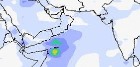

Rain Forecast Map
Oman is in for some rain. Muscat will get showers till Nov 3, 2011

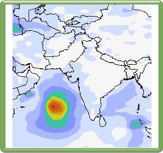
There is a big storm which will take birth near the Indian coast near the state of Kerala on November 3, 2011. This storm is likely to be a monster and present forecasts say it will hit the Pakistan coast on November 9, 2011. Oman and the Indian state of Gujarat will be spared. But it is early days. Who knows? But more about that in another article....
Share this PostPin ThisShare on TumblrShare on Google PlusEmail This

Bay Of Bengal Depression To Bring Heavy Rains To Tamil Nadu, Andhra November 13, 14 2011

A low pressure system is likely to form in the Bay of Bengal on November 10, 2011 west of Andaman islands. It will then gain strength and turn into a deep depression and move westward in the next three days. It will make landfall on November 13, 2011 at the coast of Tamil Nadu and Andhra Pradesh. Heavy rainfall is likely in these two states on November 13, 14.


Rain Forecast Map

Heavy rains likely on Nov 13, 14 in Tamil Nadu and Andhra Pradesh

Wind Speed Map Nov 13

November 13, 2011. The deep depression will make landfall. Quite strong winds
Share this PostPin ThisShare on TumblrShare on Google PlusEmail This

Latest Forecasts/Updates


Popular Posts

Search This Site