Showing posts with label low pressure. Show all posts

No Cyclone In Bay of Bengal: Heavy Rains In Northern Tamil Nadu On Novemebr 14, 2014


We recently ruled out the possibility of a cyclone in the Bay of Bengal based on the GFS model. This model said yesterday that only a low pressure area will form which will bring heavy rains to Myanmar around November 8, 2014.

Surprisingly the Canadian CMC forecast says a massive cyclone will hit the Odisha coast on November 7, 2014. Latest CMC forecasts say that the low pressure will head towards Myanmar coast strengthen into a cyclone and then swing back and hit Odisha on November 11. All very elaborate and long-winded.

The reliable European model ECMWF predicts a depression that will bring rains to Odisha around November 10, 2014.

----------------------------------------
UPDATE: NOVEMBER 6, 2014, 10 AM [IST]: CYCLONE ASHOBAA WILL FORM ON NOVEMBER 10 EAST OF ANDAMAN ISLANDS AND HIT ANDHRA COAST AT VISAKHAPATNAM ON NOVEMBER 12 NIGHT
----------------------------------------

Confusing situation. We can only wait and watch. We would bet on what the GFS says. We can be sure of a cyclone when the ever-reliable GFS confirms it. Right now all it says is a low pressure area going into Myanmar. Personally, we think the chances of a cyclone in the Bay of Bengal appear are slim. Typhoon Nuri sucked off all the energy from the Bay of Bengal.

It is quite definite now that the likelihood of a storm in the Bay of Bengal this year is little. The much
vaunted low pressure area that is hovering in the Bay will move to Myanmar on November 9. It will make landfall as a low pressure area. Lots of rain in the country, but no cyclone.

Another low pressure area will cross over into the Bay of Bengal from the Gulf of Thailand immediately after the earlier area goes to Myanmar. This system will traverse the Bay of Bengal briskly [Turn into, perhaps, a depression] bringing heavy rains to northern Tamil Nadu on November 13-14.

In short, no cyclone.


 The CMC predicts a cyclone on Nov 7

 The ECMWF says a depression on Nov 10

The GFS predicts a low pressure (or a depression] on Nov 11


A video about Typhoon Nuri and a possible storm in the Bay of Bengal

Share this PostPin ThisShare on TumblrShare on Google PlusEmail This

Low pressure area to form in south Arabian Sea today. Birth of Cyclone NANAUK?

THE LOW PRESSURE AREA FORMS ON JUNE 8, 2014

The much dreaded low pressure area will form in the southern Arabian Sea on Sunday, June 8, 2014. Why I say dreaded is because such a system forming at this time of the year usually means trouble. Read that as a big bad cyclone.

I write this update with some confidence because three forecasts, GFS, CMC and NAVGEM confirm the formation of the low pressure area.

CMC and NAVGEM say outright that cyclone Nanauk is coming. The dates differ. NAVGEM says the cyclone is going to hit Oman on June 13, 2014. CMC gives a latter date.

The more trusted GFS model confirms the formation of a low pressure area but does not confirm that it will turn into a cyclone. Let us see what it says later.

June 11, 2014. The NAVGEM forecast model shows cyclone Nanauk hurtling towards Oman. 

Share this PostPin ThisShare on TumblrShare on Google PlusEmail This

ARABIAN SEA MAY 2013: SITUATION FLUID: A LOW PRESSURE AREA HAS FORMED

A great mass of dense clouds hover over southern Arabian Sea. This mass has a great potential of throwing out many possibilities. A low pressure area? A cyclone? A super cyclone? Where? Gujarat? Oman? Pakistan?

Conditions are very fluid and model forecasts are a little bewildered too. Hence different predictions with each forecast. One thing is certain. A low pressure area has formed in the southern Arabian Sea.

For those interested, latest forecasts say the low pressure area will potter around for a couple of days (May 20) and then head towards the coast of south Oman and hit it on May 22. 2013 near Sharbatal, Sawqirah and Marmul. These areas will receive heavy rains.

But as we said conditions are very unstable and so we shall have to wait and see what happens next
Share this PostPin ThisShare on TumblrShare on Google PlusEmail This

Heavy Rain System Brewing In The Arabian Sea: Oman Or Gujarat?

I hesitate to write these words. Weather is so fickle. I looked very stupid when I predicted a tropical storm in the Bay of Bengal in the end of the April. But it all fizzled out and neither Bengal, nor Bangladesh nor Myanmar received any rains or whiff of a storm.


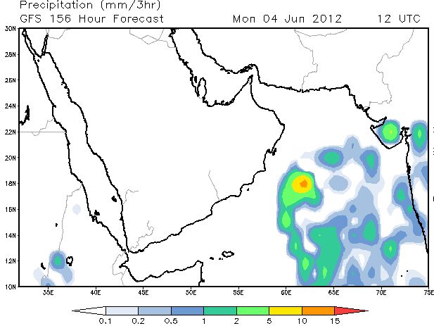
But I dare make a prediction again. Heavy rains with strong winds around the 7th of June, 2012 either in Gujarat (India) or Oman.


I say this after looking at the big mass of clouds that have formed near the Horn of Africa. In the coming days that system is going to intensify into a low pressure area and move north-west in the Arabian Sea.

NOW. The map shows the mass of clouds near the Somalian coast. These will move upwards into the Arabian Sea.
When? The mass of clouds will slowly move into the Arabian Sea in the next few days and become a low pressure area by the 2nd of June, 2012. the location then will be 14 degrees North and 62 degrees East.
June 2, 2012. The system has become a low pressure area.Location 1000 Km east of the Maldives.
Due to its influence there will be rains in Saurashtra and Mumbai on June 4, 2012.
June 4, 2012. Rains in Saurashtra and Mumbai
The question is where will be the rain system go? Towards Gujarat or Oman. On June 5 it has shifted a bit westwards; towards Oman. But it is early days to be sure. My hunch says it will head to Gujarat around June 10, 2012.


June 8, 2012. There is heavy rains off the Gujarat coast. Next two days and Gujarat gets a drenching?
June 5, 2012. Where will the low pressure area go? It has shifted slightly westward. Will it move to Oman?


CLOUD COVER FORECAST. June 4, 2012 will see overcast skies over Oman.
Share this PostPin ThisShare on TumblrShare on Google PlusEmail This

Latest Forecast Says Nov 6 Arabian Sea Storm To Be A Mere Low Pressure Area


Slightly dampening news. The expected Arabian Sea storm to be formed on Nov 6, 2011 is not going to be full-blooded cyclone (Nor a Depression). It will be a low pressure system.

The storm will form as said earlier in the Arabian Sea about 1000 Kms NW of Maldives. It will generally move towards the seas between Oman, Pakistan and Gujarat. It will reach there on Nov 10, 2011.

There will be a lot of rains in the sea and then the system will disintegrate around Nov 11, 2011. Some substantial precipitation in Sindh and Gujarat on Nov 11, 12. The remains will drift to Oman and give it some rainfall on Nov 13, 14, 15.

 Nov 6, 2011. The low pressure system is born

 Nov 8, 2011 The storm system moves north towards the seas near Oman, Pakistan and Gujarat

Nov 10, 2011. The low pressure kisses the Omani coast

 RAIN PREDICTION MAP NOV 11, 2011

Nov 11, 2011. Rainfall forecast map. Look at the amount of rains! The system then starts to fizzle out giving some good rains to Sindh and Gujarat


Share this PostPin ThisShare on TumblrShare on Google PlusEmail This

Another Forecast Model Says Arabian Sea Storm To Go To Gulf Of Aden

Disappointing forecast for those of us in India, Pakistan and Oman who love storms and rains. The NOGAPS forecast system predicts that a storm system will form in the Arabian Sea on Nov 6, 2011. In the place we have forecast; about 1000 Kms NW of Maldives. 

But this forecast says (Alas!) the low pressure system will moves towards the Gulf of Aden and reach it on the 10th of Nov., 2011!

I feel a little down, I admit. But I have found that the GFS forecast system is generally more accurate than the others. And GFS forecasts the storm system will come towards the seas of Oman, Pakistan and Gujarat.


Rain Forecast Map According To NOGAPS Forecast

 NOGAPS Forecast: Nov 6, 2011. The low-pressure area is formed

 NOGAPS Forecast: Nov 7 2011. The low pressure system moves towards the Gulf Of Aden

NOGAPS Forecast: Nov 10, 2011. The system reaches the Gulf Of Aden. Horn of Africa gets heavy rains

Share this PostPin ThisShare on TumblrShare on Google PlusEmail This

Bay Of Bengal Storm November 2011 Update: Just a Low Pressure?

 We had predicted a big storm in the Bay of Bengal which would hit the Indian coast on November 11, 2011.  The latest forecasts are rather dampening. It will be a low pressure or may be a deep depression that will hit the Indian coast at the states of Tamil Nadu and Andhra Pradesh on November 11th, 2011. Not very strong winds. But very heavy rains likely on November 12th, 2011 in north Tamil Nadu and south Andhra Pradesh. Especially the areas near the coast.

Still 12-13 days to go. Anything can happen.....

Rain Forecast Map

November 12, 2011. Heavy rains lash coastal areas of north Tamil Nadu and southern Andhra Pradesh

Wind Speed Forecast Map

November 11, 2011. Not a big cyclone. May be a deep depression about to enter the Indian coast
Share this PostPin ThisShare on TumblrShare on Google PlusEmail This

Tropical Storm To Form In Arabian Sea Near Kerala November 3, 2011

The northern Indian ocean is turbulent this year in Oct.-Nov. A low pressure area will bring heavy rains to south Pakistan on November 2, 2011. A deep depression in the Bay of Bengal will hit coastal Tamil Nadu and Andhra Pradesh November 11, 2011. AND.....!

A tropical storm is likely to form near the Kerala coast on November 3rd, 2011. It will start as a low pressure area and then move northwards. When it nears the Goa coast it will intensify into a cyclone. It will then move north-westerly in the Arabian Sea, hover around and slowly dissipate and drift towards Oman bringing some rains on Nov. 12-14, 2011.

Present Forecasts say it will not touch Gujarat (rains likely in Gujarat under its influence though. Especially on Nov. 7-8, 2011). Nor will it hit Pakistan or Oman. But hard to say for sure. Keep reading this site...
Wind Speed Forecast Maps

 November 5, 2011. The low pressure system near the Goa coast has gained strength and turned into a cyclone
November 3, 2011. The low pressure system is born near Kerala coast. Notice that the earlier system is lashing south Pakistan
Share this PostPin ThisShare on TumblrShare on Google PlusEmail This

Arabian Sea Low Pressure (Oct.-Nov. 2011) Shifts Course: Will Only Touch Oman Balochistan In For a Deluge

We had predicted quite substantial rain in Oman from 31 st October, 2011. Well, the Arabian Sea Low Pressure system that was to bring the precipitation is going to shift its course slightly. It will bring rains to Oman but in lesser areas and in less amounts. The coastal areas are going to get a drenching. Especially the island of Kalban and Dawwah. Sur and Al Kamil will get good rains too. But it is Balochistan in Pakistan which will receive the deluge from November 1, 2011. All of southern Pakistan (Sindh too)  is in for rains. Karachi on November 3rd, 2011.
(Oman will receive more rains later, till Nov. 15, as another low pressure area in the Arabian Sea will form on November 3, 2011. Read about it here)

Rain Forecast Maps

 Late Monday night. October 31, 2011. Rains to lash Oman coastal areas

November 1-2, 2011. Southern Pakistan gets a deluge. Karachi gets rainfall too.
Share this PostPin ThisShare on TumblrShare on Google PlusEmail This

Latest Forecasts/Updates


Popular Posts

Search This Site