Showing posts with label May. Show all posts

Will the tropical storm in Bay Of Bengal Turn Into Cyclone NANAUK?


A low pressure area hovers in the seas off the coast of Burma. It is 370 nautical miles south of Chittagong presently.

The question is; will the low pressure area remain just that when it makes landfall? Or will it grow stronger into a depression; or may be a cyclone. May be NANAUK might form in the Bay of Bengal. We are keeping a close eye.


The JTWC (Joint Typhoon Warning Center), which is considered a god by storm trackers and predictors, says there is a 50-50 chance of a tropical storm developing.


The low pressure area is likely to intensify rapidly tomorrow into a tropical storm (May 24, 2014). Then it will move towards Bangladesh and then intensify rapidly again on Monday (May 26, 2014). 


Chances are, it is Nanauk in the making.... But will the storm gain enough strength to qualify in the eyes of IMD (Indian Met. Dept.) to be honored with a name; NANAUK?


UPDATE: MAY 24, 2014, O430 GMT

Present forecasts say the system will intensify in the next day or two and make landfall. Opinions vary. Orissa-West Bengal coast. Or Bangladesh. The tropical storm is unlikely to gain enough strength to be given a name, Nanauk. Certain forecasts say that it will not be a mere low pressure, but a deep depression. This system will be closely watched by us.



Share this PostPin ThisShare on TumblrShare on Google PlusEmail This

Expected Low Pressure Area in Bay of Bengal Will Drench Bengal Or Bangladesh?

A low pressure area is swirling in the Bay of Bengal off the Burmese coast. Where will it go?

Forecasts differ slightly. One says it is bam-bam-woosh for Bangladesh. Very heavy rains from Monday (May26, 2014). Others say the low pressure area will first affect coastal Orissa and West Bengal.And then it will move into Bangladesh two days later, that is on Wednesday (May 28, 2014).

But expect heavy rains all the same. Question is, will it be West Bengal first. Or Bangladesh and then Assam, with West Bengal escaping with comparatively less precipitation.

 Alternative 1: The system hits Bangladesh on May 26, 2014  and then moves over into Indian NE

Alternative 2: Drenches Orisaa, West Bengal on May 26, 2014. And then moves into Bangladesh on May 28 (Wednesday).

(Will it turn into Cyclone NANAUK?)
Share this PostPin ThisShare on TumblrShare on Google PlusEmail This

Bangladesh, Indian NE in for a deluge on May 26-27, 2014

May 24, 2014. The massive rain-bearing low pressure as it heads into Bangladesh. Maximum rainfall will be on May 26-27, 2014.

Bangladesh is in for a real pounding by the rains gods. A low pressure area will form within a day or two off the coast of Myanmar. This system will then move north straight into Bangladesh. Thou the rains will start from Sunday (May 25, 2014), the heaviest lashing will occur on Tuesday (May 27, 2014.

The Indian NE states too will receive heavy rains as the system will move there from Bangladesh.

Chances of flooding, folks. As the precipitation will be a deluge, no less.


Share this PostPin ThisShare on TumblrShare on Google PlusEmail This

Two Low Pressure Areas: Rains In Oman And West Bengal Expected

XWF WEATHER PREDICTION MAP: SATELLITE IMAGE TAKEN TODAY SHOWS THE TWO LOW PRESSURE AREAS, ONE EACH IN THE BAY OF BENGAL AND ARABIAN SEA (WILL FORM ON MAY 30)

Today we shall talk about two low pressure areas (LPA). One in the Arabian Sea, the other in the Bay of
Bengal. One has already formed. The other will take shape on May 30, 2013.

As we had forecasted earlier,  a low pressure has formed in the Bay of Bengal. We had also said that this system would make landfall two days later and bring heavy rains in Bangladesh and West Bengal. Well, there has been a slight change of plan. The LPA will not go straight into Bangladesh. But it will hover around for some time near the Orissa coast then move into land on May 29, 2013 at the Orissa-West Bengal border. It will then curve into West Bengal bringing heavy rains in the state for the next 3-4 days. North Bengal will get rains on June 1, 2013. Heavy rains, if I may so.
.
Then the system will drench north Bangladesh on June 2, 2013. I am talking of Rangpur, Dinajpur, Panchgarh and Thakurgaon.

The Arabian Sea LPA will form on May 30, 2013. It will move along the Oman coast in a northerly direction, giving rains to the coastal areas. Muscat may get some rains on June 4-5, 2013. It may rain in Abu Dabhi, Dubai and Doha around May 6, 2013. Muscat will get some good showers on June 5-6, 2013.
Share this PostPin ThisShare on TumblrShare on Google PlusEmail This

Low Pressure Area To Bring Heavy Rains In Bangladesh And West Bengal Next Week

SATELLITE IMAGE TAKEN TODAY (MAY 25, 2013) SHOWS THE AREA OF DENSE CLOUDS NEAR THE MYANMAR COAST IN THE BAY OF BENGAL. THESE WILL GIVE BIRTH TO THE LOW PRESSURE AREA ON MAY 27.

Bangladesh and West Bengal are in for a thorough drenching

next week. This will be as a result of a low pressure area that is likely to form in the Bay of Bengal on May 27, 2013.


Now this rain system will form a few hundred kilometers south of the Bangladesh coast.Then it will start moving northwards gradually in the next two days and make landfall on May 29, 2013.

Very heavy rains are forecast in SW Bangladesh on May 29. It will also rain heavily in Gangetic West Bengal on May 30.

After that the system will move into Assam on June 1, 2013.

The verdict? Very heavy rains in Bangladesh from May 29 to May 31.
Share this PostPin ThisShare on TumblrShare on Google PlusEmail This

A Rain System Will Touch Southern Oman On May 30, 2013

Presently things are very boring in the North Indian Ocean after the departure of MAHASEN. It is only in the end of the month that the SE monsoons will start approaching South Asia. But there is another interesting development in the Arabian Sea. No it is not a cyclone, nor even a depression.


But I am talking of the mass of rain-bearing clouds in south Arabian Sea. They have been there for quite a few days now. Initially it was expected that they will give birth to a substantial storm.

But forecasts now say the system will start moving gradually towards the coast of southern Oman and give some rains on May 30, 2013. It will rain heavily in the next two days in the sea off the coast. Then this system will move in a  NE direction and bring heavy rains to the Saurashtra (India) coast on May 6, 2013.

There are still some days to go. Will the rain system behave as we have predicted? Or will it change its mind and turn into something more substantial?

Let us wait and watch.

Xtreme Weather Rain Prediction Map; May 30, 2013. Rainfall in southern Oman

Xtreme Weather Rain Prediction Map: June 2, 2013. Heavy rains off the coast of southern Oman

Xtreme Weather Rain Prediction Map: June 5, 2013. The system now reaches the Gujarat coast and brings heavy rains

Share this PostPin ThisShare on TumblrShare on Google PlusEmail This

ARABIAN SEA MAY 2013: SITUATION FLUID: A LOW PRESSURE AREA HAS FORMED

A great mass of dense clouds hover over southern Arabian Sea. This mass has a great potential of throwing out many possibilities. A low pressure area? A cyclone? A super cyclone? Where? Gujarat? Oman? Pakistan?

Conditions are very fluid and model forecasts are a little bewildered too. Hence different predictions with each forecast. One thing is certain. A low pressure area has formed in the southern Arabian Sea.

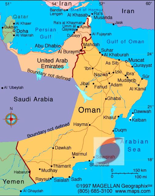
For those interested, latest forecasts say the low pressure area will potter around for a couple of days (May 20) and then head towards the coast of south Oman and hit it on May 22. 2013 near Sharbatal, Sawqirah and Marmul. These areas will receive heavy rains.

But as we said conditions are very unstable and so we shall have to wait and see what happens next
Share this PostPin ThisShare on TumblrShare on Google PlusEmail This

A TROPICAL STORM (PHAILIN?) TO STRIKE SOUTH OMAN ON MAY 25, 2013

The North Indian Ocean seems to throw out tropical storms by the handfuls this year. After the weak MAHASEN in the Bay of Bengal, forecasts say a new storm is brewing in the Arabian Sea.

Southern Arabian Sea has seen a mass of restless clouds since a few days. This system of rain-bearing clouds are going to spawn a storm around May 21, 2013.

GROUND ZERO: MAY 26, 2013
It will start very innocuously in the Arabian Sea, 1000 miles east of the Horn of Africa. A low pressure area will develop. This system will slowly drift NNW gaining strength gradually. Within a day or two it will churn up winds of about 40-50 kph. A depression.

This depression will keeping moving towards the south Oman coast gaining strength all the time. As it nears the coast on May 24-25, 2013, it will be cyclone strength. Winds of about 80-90 kph.

The tropical storm will hit the south Oman coast between Duqm and Sawqirah, on May 25-26, 2013, accompanied with strong winds and very heavy rains.

Since the maximum winds are forecasted to be about 80-90 kph one can safely label it a cyclone.

May be PHAILIN  cyclone is coming.

EXPECTED PATH OF ARABIAN SEA TROPICAL STORM MAY 2013: MAY 22-MAY 26, 2013

Share this PostPin ThisShare on TumblrShare on Google PlusEmail This

Latest Forecasts/Updates


Popular Posts

Search This Site