Showing posts with label india. Show all posts

European Model, ECMWF Paints Gloomy India Monsoon 2017 Picture

APRIL 13, 2017, THURSDAY

The rainfall prediction for India this year's monsoon is poor. That is if the prediction by the European weather forecast agency's ECMWF model is to be believed. 

On the whole rainfall will be normal till September end in most parts of India, barring Kutch, parts of Saurashtra, North Gujarat, entire Rajasthan, Haryana, Punjab, Jammu Kashmir, Bengal and the North Eastern states. Rainfall will be deficient in these areas. On the whole it will bring down the monsoons to 90-95% of average. That is if there are no depression/cyclones in October/November which bring prodigious amounts of water and push up the percentage and reduce the gloomy scenario.

The ECMWF says that there will be good rains on the Indian west coast barring Gujarat in July and August. But the rains will dry up in August, September in the whole country. I guess this will be because of the bad man El Niño kicking in then.


There is bad news for Pakistan and Bangladesh too. It will be below normal monsoon in these two countries.

This prediction is based on analysis of climate data available till March 1, 2017 by the premier forecast agency. It would be interesting to see if there are changes in subsequent long range forecasts.


Share this PostPin ThisShare on TumblrShare on Google PlusEmail This

Mumbai, Konkan Faces Deluge On September 24, 2016

SEPTEMBER 15, 2016, THURSDAY 

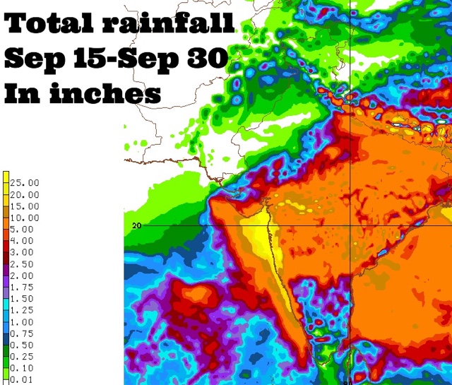
Coastal Maharashtra and the city of Mumbai are in for extremely heavy rains around September 24, 2016. Some forecast models suggest about 25 inches of rain in these places by the end of the month. 

The rest of Maharashtra, south Gujarat, some districts of Saurashtra and north, central Gujarat may also receive 2-5 inches of rain at that time.

This is going to happen because a Bay of Bengal cyclonic circulation will clamber over peninsular India, emerge near the Konkan coast in the Arabian Sea around September 24 and intensify into a well marked low pressure area.

Where will the low pressure system go after that? Hard to say now. Some forecast models say it will weaken and move into northern Maharashtra-western Madhya Pradesh. But this is not certain.

It might well decide to take a stroll in the Arabian Sea.
----
"Latest GFS forecast says the Arabian Sea low pressure system will hit northern Oman on September 29, 2016 with heavy rains."
----
Things are going to happen in the coming days in the Indian west coast. Mumbai. Prepare for floods. The GFS model says heavy showers in Konkan, Mumbai will start much before September 24. In the next few days. Heavy rains are expected in Maharashtra on September 17-18.

Very heavy rains are possible in Mumbai in next 72 hours. This will be just a precursor to the expected deluge on September 24.

Forecast models are predicting a sudden explosion of monsoon activity with two strong low pressure systems developing, one each in the Arabian Sea and Bay of Bengal around September 24, 2016. That day seems to be D-Day. Deluge day.

Situation presently is fluid. So it is hard to say where the rain systems will go. One thing is certain. Some places in South/West Asia are in for a lot of rains in the coming days.


Share this PostPin ThisShare on TumblrShare on Google PlusEmail This

Two Rain Systems Imminent In India

SEPTEMBER  7, 2016, WEDNESDAY 

The monsoons may be at an ebb now but a strong revival is in the offing in the coming 10 days. Many parts of India, Bangladesh and Myanmar may receive heavy rains.

This will be possible because of two low pressure areas. Both will travel a long time without weakening and cross a long distance. 

Let us discuss in detail.

The first is the low pressure/cyclonic circulation that is hovering over Bengal presently. In the coming days it will move along the coast in the Bay of Bengal. First Odisha then Andhra Pradesh. It will enter the state on September 15 and move through Telangana, Maharashtra and emerge in the Arabian Sea just off the Mumbai coast, south of Saurashtra on September 17. Where it will go after that remains to be seen. It may move into Gujarat. Or it may dissipate in the Arabian Sea. Or it may intensify into a depression or tropical cyclone.

Folks in Gujarat, Oman and Pakistan must track this system with interest. Forecast models say it will intensify after emerging in the Arabian Sea.

The second rain maker system will come from the South China Sea. It will be born west of the Philippines, intensify into a depression or tropical storm and hit central Vietnam on September 13, 2016. After that it will move through Cambodia, Myanmar, and emerge in the Bay of Bengal near the Bangladesh/Bengal coast and intensify on September 17, 2016.

What this system does after that is uncertain at this stage.

We are not saying a tropical cyclone is imminent in the North Indian Ocean but if forecast models are to be believed a major rain system is likely in both the Bay of Bengal and the Arabian Sea in the coming days.

Let us see.

UPDATE, SEPTEMBER 8, 2016, THURSDAY 

The picture remains hazy. Further latest data from forecast models confirms a strong low pressure area off the Andhra Pradesh coast on September 18. Also confirmed is the tropical storm/depression hitting central Vietnam on September 13. The CFS model predicts heavy showers in Konkan and Mumbai around September 24, 2016.


Share this PostPin ThisShare on TumblrShare on Google PlusEmail This

Indian Monsoon Shows Receding Trend

AUGUST 31, 2016, WEDNESDAY 

The monsoon in India this year has been unremarkable as compared to other years. Though it has rained every where in little or more amounts, there have been few powerful rain systems. There was only one this year. Last month a low pressure system hovered over Madhya Pradesh for a week bringing floods.

Otherwise generally unremarkable. The Indian Met Department has reduced its forecast from above average to average rainfall in 2016. Forecasts by global forecast models of a bountiful Indian monsoon has been proved wrong.

The culprit is La Niña. The absence of it. Expectations that the flooding La Niña would be born in July or August have been belied. September has come and ENSO conditions are still neutral. In short, no La Niña. The monsoon are preparing to withdraw from South Asia.

In the coming days monsoon rains in Rajasthan, Gujarat, Punjab, Haryana will begin to decrease. Unless of course either the Arabian Sea or Bay of Bengal throw out a low pressure system or a depression. None are expected in the near future.

A low pressure area will affect Bangladesh, Bengal and Bihar on September 5-6 bringing good rains. Otherwise it remains sedate in South Asia.

Come October and chances of a tropical cyclone in either Arabian Sea and Bay of Bengal increases.


Share this PostPin ThisShare on TumblrShare on Google PlusEmail This

Good Rains In Andhra, Delhi Today

AUGUST 28, 2016, SUNDAY
 
The circulation over Sindh has brought good rains to the province and western Kutch in Gujarat. This will now move to western Rajasthan and then swing into northern Pakistan in the coming 3-4 days. The cyclonic circulation in the Bay of Bengal will bring heavy showers to coastal Andhra and Telangana in the coming 36 hours. This system will move north through Odisha, Jharkhand, Bihar onto Uttar Pradesh in the coming days bringing increased precipitation in these regions.
Heavy showers in Andhra Pradesh, Telangana till Monday night.
 
Heavy showers in northern Rajasthan which will spread to Delhi, Haryana, Punjab by Monday morning.
 
Showers in Gujarat till today evening.
 
A heavy shower in Diu early Monday morning. 1-2 inches expected.
 
Monsoon rainfall forecast August 28 Sunday Andhra Rajasthan Delhi India
Raining in Chennai, Sindh, Bangladesh and northern Rajasthan 
 
Share this PostPin ThisShare on TumblrShare on Google PlusEmail This

Light Showers In Gujarat Till Sunday, Heavy Night Rains In Delhi

AUGUST 26, 2016, FRIDAY 
 
A low pressure area is forming off the Andhra Pradesh coast. We can expect heavy rains in the state in the coming days.
 
The cyclonic circulation over southern Rajasthan persists. But it has weakened as evidenced by low rainfall activity in Gujarat yesterday. But it will exert influence over the state till Sunday. Most parts will see dull drab weather with light rain.
Isolated heavy showers in central Gujarat around Khambhat, Kheda, Bharuch.
Intermittent showers in Kutch till Saturday night.
 
Light to medium rains in Kutch, Saurashtra in the next 48 hours. Bhavnagar, Surendranagar, Morbi, Amreli districts.
 
There might be a couple of heavy showers in Rajkot today late night.
 
Good showers in Kutch till early Saturday morning. Showers in Dwarka, Jamnagar districts Saturday morning.
 
Showers are expected in Andhra Pradesh, Telangana, Madhya Pradesh during the day till evening. Heavy rains may arise in Delhi, Haryana, Punjab, western Uttar Pradesh, northern Rajasthan late in the night till Saturday morning.
WARNING FLASH........CERTAIN PARTS OF SAURASHTRA (RAJKOT, SURENDRANAGAR, AMRELI, JUNAGADH, BHAVNAGAR) MAY SEE VERY HEAVY RAINS BEGINNING TONIGHT, LASTING TILL SATURDAY EVENING
 
 
Share this PostPin ThisShare on TumblrShare on Google PlusEmail This

Both Rain Systems Will Dissipate On Sunday, DIAMMU To Reach Gujarat

UPDATE, SUNDAY, AUGUST 21: Latest forecasts say the low pressure system will move western India by Wednesday.


AUGUST 20, 2016, SATURDAY 

The two low pressure areas that were expected to maintain monsoon rains in India will collapse on Sunday. The one that is presently over northwest Madhya Pradesh will move to southeast Rajasthan tomorrow and fizzle out. Meanwhile the remains of tropical storm DIAMMU are presently moving past Myanmar. By tomorrow it will reach Bangladesh and die down quickly.

Heavy rains in northeastern Madhya Pradesh, parts of Rajasthan till Monday.

Heavy rains in Nagaland, Manipur, Mizoram, Myanmar, Bangladesh till Monday morning.

Very heavy rains in Bangladesh on Sunday.

Heavy rains in parts of West Bengal, Bihar, eastern Uttar Pradesh on Monday.

 UPDATE: AUGUST 21, 2016, SUNDAY 

Things have changed. The remnant of tropical storm DIAMMU, a low pressure system, which is moving over Bangladesh now may reach southern Rajasthan, Kutch, northern  Gujarat on August 24-25. It will bring rains even to Sindh possibly on Friday.

Earlier forecast was the circulation would dissipate over Bihar-eastern Uttar Pradesh today.

The circulation over northwest Madhya Pradesh fizzling out as predicted. DIAMMU remains moving into West Bengal. By Thursday it will reach southern Rajasthan, north Gujarat, Kutch.


Share this PostPin ThisShare on TumblrShare on Google PlusEmail This

August 16, 2016: Weather Forecast Update: Low Pressure System Moving Into Bengal

AUGUST 16, 2016, TUESDAY

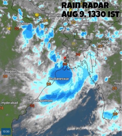
A low pressure area (NOAA calls it 97B) has formed in the Bay of Bengal. By tomorrow it will inland into Odisha-west Bengal. The cyclonic circulation over Uttar Pradesh is dissipating.

The depression/low pressure system from the South China Sea will reach eastern India by August 21. This will bring more rains to West Bengal, Bihar, Jharkhand, Uttar Pradesh.

The GFS forecast model envisages a procession of lows moving into West Bengal, Bihar, Jharkhand, Uttar Pradesh one after another till August end. I think we are staring at floods in these states in the coming fortnight.

Very heavy rains in eastern Madhya Pradesh, and adjoining areas of Uttar Pradesh, Chattisgarh till Wednesday morning.

Rains in Uttar Pradesh in next 36 hours.

Heavy showers in Odisha (Sambalpur) till tomorrow morning.

Rains to increase in Gangetic West Bengal, Bihar, Jharkhand as the low pressure system moves in from tomorrow.

On Thursday heavy rains to move to Bihar, Uttar Pradesh, Chattisgarh.

The rain radar shows the circulation over Uttar Pradesh petering out as the low pressure system moves into West Bengal from the Bay of Bengal.


Share this PostPin ThisShare on TumblrShare on Google PlusEmail This

NOAA Rain Forecast Maps August 15, 2016, India

Share this PostPin ThisShare on TumblrShare on Google PlusEmail This

August 15, 2016: Weather Forecast Update: Flooding Rains In Parts Of Madhya Pradesh, Uttar Pradesh


AUGUST 15, 2016, MONDAY

The cyclonic circulation over northern Madhya Pradesh will peter out by tomorrow night but not before it floods areas of the state north of Jabalpur.

Another low pressure area is going to move in soon into West Bengal from the Bay of Bengal by tomorrow. This system will bring heavy rains to West Bengal, Bihar, eastern Uttar Pradesh in the coming 3-4 days.

Meanwhile, a South China Sea tropical cyclone will reach India after weakening into a low pressure area on August 21 after traversing Vietnam, China, Laos, and Myanmar. This system will have great stamina and may reach western Madhya Pradesh by August 24.

So we see it is going to be a very wet eastern India in the coming 7 days as it is hammered by 2 rain systems, one after another.

Flooding rainfall in area between Jabalpur and Kanpur till Wednesday evening. Parts of northern Madhya Pradesh and eastern Uttar Pradesh to be worst affected.

Worst affected districts in Madhya Pradesh will be Khajuraho, Satna, Katni, Damoh.

RELATED: NOAA Forecast Maps


Heavy rains in Uttar Pradesh as the Bay of Bengal low pressure system moving into West Bengal.


Share this PostPin ThisShare on TumblrShare on Google PlusEmail This

August 14, 2016: Weather Forecast: Very Wet Uttar Pradesh, Eastern Madhya Pradesh, Chattisgarh Ahead

AUGUST 14, 2016, SUNDAY 

The low pressure area lies over eastern Uttar Pradesh. It will weaken and dissipate in the next 72 hours but it will give damaging precipitation to eastern Uttar Pradesh, eastern Madhya Pradesh and Chattisgarh.

A Bay of Bengal low pressure area is likely to develop off the West Bengal coast by August 16. 

Also another low pressure system may reach eastern India on August 21 from the South China Sea. The low may form in the South China Sea soon. It may intensify into tropical storm hit northern Vietnam-southern China then weaken. But it may travel to India.

Moreover two tropical cyclones are heading for Japan. CHANTHU and CONSON. CONSON will affect part of Hokkaido island tomorrow with 75 km/h winds. CHANTHU will kiss by the eastern shores of the country near Tokyo with 100 km/h winds on August 18 and then reach Hokkaido on August 19, 2016.

Very heavy rains in eastern Madhya Pradesh (around Jabalpur region) till Monday morning.

Heavy rains in Bhopal, Narsinhpur, Hoshangabad, Raison, Katni, Panna districts of MP till Sunday night.

Very heavy rainfall in parts of eastern Uttar Pradesh (Kanpur, Banda, Chitrakoot, Fatehpur) and northeast Madhya Pradesh (Satna, Rewa) on Monday.

Heavy rains in Chattisgarh (Korba, Bhilai) on Monday-Tuesday.

FLOODING EXPECTED DUE TO INCESSANT RAINFALL IN PARTS OF NORTHEAST MADHYA PRADESH (Chhatarpur, Damoh, Panna, Satna districts).

The rain radar at 8:30 AM, Sunday, shows heavy rains in parts of Uttar Pradesh, Delhi, Haryana and Bangladesh. But the real concern is eastern Madhya Pradesh and Chattisgarh which faces a deluge in the next 72 hours.


Cyclones CONSON and CHANTHU to affect Japan in a span of 4 days.


Share this PostPin ThisShare on TumblrShare on Google PlusEmail This

August 13, 2016: Weather Forecast Update: Deluge In Northwest Madhya Pradesh

AUGUST 13, 2016, SATURDAY

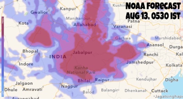
The upper air cyclonic circulation lies over northern Madhya Pradesh-eastern Uttar Pradesh. It will continue to bring flooding rains to Madhya Pradesh, especially the northeastern segment (Rewa-Sewa) and many parts of eastern Uttar Pradesh.

The system will hover around the region till August 16, 2016.

Monsoon activity will increase in all over India except the five southern states from August 16.

STORM POSSIBILITY TODAY: A low pressure area is developing in the Gulf of Tonkin off the coast of Vietnam. It may move into the South China Sea and intensify into a tropical cyclone in the coming days. Areas to be affected are northern Vietnam, China (Guangdong, Hainan, Guangxi, Yunnan)

Very heavy continuous rains in northeastern Madhya Pradesh (Satna, Rewa, Singrauli, Shahdol, Sidhi), parts of northern Chattisgarh and southeast Uttar Pradesh) till Sunday morning.

Heavy showers in Jabalpur, Bhopal till Sunday morning.

Moderate to heavy widespread rains in Uttar Pradesh and northern Madhya Pradesh in next 48 hours.

Heavy rains in Allahabad on Monday.


Satellite India August 13 weather forecast  monsoon


Rain radar shows heavy rains in parts of Madhya Pradesh, Uttar Pradesh and Rajasthan.

NOAA RAIN FORECAST


Share this PostPin ThisShare on TumblrShare on Google PlusEmail This

AUGUST 12, 2016: Weather Forecast Update: Chattisgarh, Madhya Pradesh Stare At Floods

AUGUST 12, 2016, FRIDAY

After Gujarat, Rajasthan and West Bengal the monsoon focus is on Chattisgarh. Then Madhya Pradesh faces incredibly a week of continuous rain till August 18. Meanwhile as the Rajasthan cyclonic circulation is in its death throes, rains over Delhi, Haryana will lessen, then stop.

The circulation that was formerly a low pressure area over West Bengal lies over Bihar-Jharkhand. This system will move to Chattisgarh and then hover over northeast Madhya Pradesh causing dangerous flooding precipitation in parts of the state for a week. Another low pressure area which will creep in from the Bay of Bengal on August 15-16 will add to the state's misery.

Forecast models are also hinting at the possibility of a cyclonic circulation forming over western Madhya Pradesh-southern Rajasthan on August 20-21, hence bringing another spell of rains to Rajasthan, Gujarat and possibly Sindh.

The GFS model begs to differ. It predicts a Bay of Bengal low pressure area forming on August 20-21 , moving through Andhra, Telangana onto Maharashtra, Gujarat on August 23. It expects another Bay of Bengal low hitting Gujarat on August 28-29. But one should be sceptical as GFS forecasts change rapidly at times.

Very heavy rains in northern Chattisgarh (Ambikapuram, Surajpur) northeastern Madhya Pradesh (Singrauli, Rewa) till Saturday morning.

Heavy rains in northeast Madhya Pradesh (Katni, Jabalpur) on Saturday. Rains will spread to other parts of the state (Omkareshwar, Itarsi) on Sunday.

HEAVY FLOODING RAINS IN EASTERN MADHYA PRADESH ( Jabalpur, Damoh, Katni belt) TILL AUGUST 19, 2016.


Rain radar India August 12
This rain radar image taken at 0630 hours IST shows the cyclonic circulation bringing heavy rains to Chattisgarh, northeastern Madhya Pradesh and parts of eastern Uttar Pradesh.

NOAA FORECAST MAPS


Share this PostPin ThisShare on TumblrShare on Google PlusEmail This

NOAA 24 Hours Forecast Maps: August 11, 2016


AREAS OF FOCUS

SOUTH ASIA

NOAA forecast rain India August 11

DELHI


JHARKHAND 


Share this PostPin ThisShare on TumblrShare on Google PlusEmail This

August 11, 2016: Weather Forecast Update: Heavy Rains In Delhi,Jaipur,West Bengal, Jharkhand

AUGUST 11, 2016, THURSDAY

The remnants of the Rajasthan cyclonic circulation will deluge northern Rajasthan, western Uttar Pradesh, Delhi, parts of Haryana in the next 48 hours till it dissipates.

The low pressure area presently over West Bengal will weaken in the next 24 hours and then meander over northern Chattisgarh region.

Another Bay of Bengal low pressure system will develop near Odisha coast on August 15-16. Present indications are it will travel through Odisha, Chattisgarh and onto northern Madhya Pradesh by August 19.

Heavy rains in Beawar, Jaipur, Ajmer, Sikar in Rajasthan till Friday morning.

Heavy rains in Gurgaon, Haryana, Delhi, western Uttar Pradesh on Friday, August 12. May continue till Saturday.

Heavy rains in parts of West Bengal till Friday morning. Rains to shift to Jharkhand (Ranchi) tomorrow.

Heavy rains in parts of Madhya Pradesh (Jabalpur, Satna, Rewa), Chattisgarh (Bilaspur) on Saturday.

Chattisgarh may face flooding situation owing to continued rains that are possible for a week ending August 18. The formation of a Bay of Bengal low pressure system on August 16 will enhance rains in the region.

RELATED: NOAA Forecast MAPS, AUGUST 11-12

Rain radar monsoon India August 11
This rain radar image taken at 0730 IST shows very heavy rains in Jaipur area of Rajasthan, Delhi and Haryana. Good rains in Gangetic West Bengal.

August 11, 1630 IST: Raining very heavily in northern Rajasthan, Delhi. One fears flooding. Heavy rains in West Bengal, Jharkhand, Bihar.


Share this PostPin ThisShare on TumblrShare on Google PlusEmail This

August 10, 2016: As Bengal Storm Weakens, Monsoon To Intensify From August 15


AUGUST 10, 2015

The Rajasthan circulation system will start dissipating from Thursday. The Bay of Bengal low pressure system currently over West Bengal will move to Bihar-Jharkhand and weaken gradually.

The next monsoon system will form off Odisha coast on August 15. Meanwhile overall Asian monsoon situation will be boosted with two upcoming storm systems in west Pacific Ocean. One, a depression off Vietnam coast on August 14. Two, an emerging typhoon in South China Sea.

This Bay of Bengal system is expected to move through Odisha, Chattisgarh, Jharkhand, Bihar, Uttar Pradesh.

These two storms will buck up rainfall activity in entire South East Asian region, in Vietnam, Cambodia, Laos, northern Thailand, Myanmar. This will have positive repercussions on South Asia monsoon.

The cyclonic circulation over Rajasthan will hover over the state, weakening all the time. It will bring heavy rains to different parts of the state till Saturday.

The venerable CPC, Climate Prediction Center, the American climate forecast agency foresees poor rainfall in India from August 16 to August 23. The lean spell may extend longer. The agency further says, at present, ENSO conditions are neutral. That is no La Niña yet.

Both the NMME and Canadian CANSIPS models predict average or below average rains in India in September except for some southern states.

Heavy rains in Chittorgarh-Bhilwara-Shahpur belt till Thursday morning.

Heavy rainfall in entire northern Rajasthan till Friday, August 12, evening.

Heavy rains in West Bengal, Tripura, Meghalaya, Bangladesh, Jharkhand till Thursday morning.

Heavy rains in Jharkhand (Ranchi) till Thursday.

Heavy rains in parts of Uttar Pradesh (Jaunpur), northern Chattisgarh on Friday, August 12.

Low pressure system to form in Bay of Bengal close to Odisha-West Bengal coast on August 16.

Heavy rains in parts of Bangladesh (Chittagong) and around Kolkata.

Clusters of thunderstorms in Rajasthan.

NOAA FORECAST MAPS 


Rainfall in last 24 hours

Share this PostPin ThisShare on TumblrShare on Google PlusEmail This

NOAA Forecast Maps, India, August 9, 2016, Tuesday

Share this PostPin ThisShare on TumblrShare on Google PlusEmail This

Weather Forecast Update: Wet Rajasthan Ahead, Low Heads For Bengal

AUGUST 9, 2016, TUESDAY

The cyclonic circulation over southern Rajasthan will flare up for 24 hours bringing very heavy rains over the region. It will move away from the adjoining north Gujarat, hence rainfall activity there will gradually cease.

Under the influence of this system heavy rains will continue in entire Rajasthan till August 12, Friday.

The storm system hovering off the coast of  West Bengal will bring moderate to heavy rainfall in Bangladesh, West Bengal, Jharkhand, Bihar, Meghalaya and Tripura in the coming days.

Meanwhile another Bay of Bengal low pressure area will form August 15. As a result monsoon activity will dramatically increase in eastern India, in Odisha, West Bengal, Jharkhand, Bihar, Chattisgarh.

Forecast models are hinting at the formation of a big typhoon on August 13, 2016, in west Pacific Ocean. The tropical cyclone, which will probably be named CHANTHU, will be formed north of the Luzon coast, in Philippines and may go onto hit the Chinese province of Guangdong at Hong Kong-Macau on August 17-18, 2016. Let us see how things develop.

Very heavy rains in southern Rajasthan (Abu, Sirohi, Rajsamand, Chittorgarh) till Wednesday morning. Rains will move to Jodhpur by Wednesday noon, to Nagaur, Bikaner by Wednesday evening.

Moderate to heavy rainfall to continue in central, northern Rajasthan (Ajmer, Jaipur) till Friday, August 12, 2016.

Very heavy rains in West Bengal, Bangladesh, Tripura, Meghalaya in next 48 hours, till Thursday morning.

Heavy rains in Jharkhand (Ranchi, Jamshedpur) on Friday-Saturday.

Heavy showers in parts of Gujarat:  Bhavnagar, Palanpur, Deesa, Bharuch, Ankleshwar today evening.

RELATED: NOAA Forecast Maps, August 9, 2016

The currently existing rain systems/cyclonic circulations over India. One over NW Madhya Pradesh-Rajasthan, one in Arabian Sea off Saurashtra coast and the newly formed low off West Bengal.


The cyclonic system over Rajasthan will bring rains to the state till Friday 

The low pressure system off the Odisha-West Bengal coast is drenching coastal Odisha and West Bengal.

Share this PostPin ThisShare on TumblrShare on Google PlusEmail This

August 8, 2016: NOAA GFS Rain Forecast Maps, India


August 8, 2016, Monday: The focus of attention is southern Rajasthan. The low pressure area will bring heavy rains to region and adjoining north Gujarat, Kutch in the coming days.


MICRO-LEVEL RAIN FORECAST FOR RAJASTHAN 


RAIN FORECAST TILL TUESDAY MIDNIGHT 


Share this PostPin ThisShare on TumblrShare on Google PlusEmail This

Latest Forecasts/Updates


Popular Posts

Search This Site