Showing posts with label low pressure system. Show all posts

Heavy Rains In Gujarat Till July 27

JULY 24, 2017, MONDAY

The low pressure area presently over south Rajasthan will still cause very heavy rainfall in north and northeast Gujarat in the next 48 hours. The districts affected will be Banaskantha, Sabarkantha, Mahesana, Patan, Aravalli, Ahmedabad, Dahod, Mahisagar, Kheda, Anand.

The rains will begin to move to Kutch by Wednesday afternoon and may continue into Thursday, July 27. The system is expected to weaken and dissipate over northern Kutch-Sindh border regions by Friday.

Other possibilities are it moves north into Rajasthan (GFS) OR it moves into the Arabian Sea via Saurashtra on Thursday. (German model). This possibility says the system will retain its strength and will move towards northern Oman.

Only the German model predicts that the system will intensify into a deep depression as it enters the Arabian Sea off Kutch-Karachi coast.

The Indian Meteorological Department seems to think the system will move north into Rajasthan. In the latest morning bulletin today it predicts decreasing rains in Gujarat from Tuesday evening and heavy rains in Rajasthan.

As to the other low pressure system over India, in West Bengal..... It will move through Bihar, Jharkhand, northern Chattisgarh onto Madhya Pradesh in the coming days. It is at present expected to dissipate over northwest Madhya Pradesh by July 28.

West Bengal, Jharkhand, parts of Chattisgarh and Madhya Pradesh will receive the most precipitation from this system.


Share this PostPin ThisShare on TumblrShare on Google PlusEmail This

Gujarat In For A Deluge In Mid July?

JULY 6, 2017, THURSDAY

If forecast models are to be believed, the Indian state of Gujarat is in for flooding rainfall beginning mid July as two low pressure systems may hit it one after another by July 22.

The first system will be born in Bihar/Jharkhand on July 9 as an upper air cyclonic circulation. It will move onto eastern Uttar Pradesh, then northern Madhya Pradesh by July 12. It will have intensified into a big rainmaker by then. By July 14-15 it will be hovering over southeastern Rajasthan.

But it's southern quadrant will bring the maximum rainfall. This will arrive in Gujarat/Saurashtra/Kutch by July 15. So expect heavy to very heavy rains in the state beginning July 14. Before that parts of northwestern Madhya Pradesh and southeast Rajasthan will receive a deluge on July 12-14.
-------
इसे हिंदी में पढ़े
-------

Not only Gujarat, Madhya Pradesh, Sindh, the GFS model predicts the monsoon is going to enter a very active stage from July 12 and which will continue till the end of July. Many low pressure systems are likely with heavy rains in entire peninsular India. Especially Andhra Pradesh, Telangana, Chattisgarh, Maharashtra.

The system may move onto Sindh, Pakistan by July 15-16, bringing possibly very heavy rains in the province, including the capital Karachi.

THE SECOND SYSTEM will form over Bangladesh on July 15-16 and move quickly through West Bengal, Jharkhand, Madhya Pradesh, east Rajasthan and hit Gujarat on July 20. This one will be even bigger than the first.

It may intensify into a depression by the time it reaches Gujarat. And that system too may flood southern Sindh and Karachi by July 21.

So strong is this depression going to be that it will enter Arabian Sea on July 21 and intensify further into a deep depression, may be even a cyclone. It may hit Balochistan or northern Oman after that but that remains to be seen.

The GFS envisages the low pressure system reaching Oman by July 22 bringing 2-4 inches of rain in the country, especially the northern parts (Muscat included).


Share this PostPin ThisShare on TumblrShare on Google PlusEmail This

Arabian Sea, Bay of Bengal May Spawn 2 Systems September 23, But How Big?

SEPTEMBER 19, 2016, MONDAY
 
The two seas which hurl storm systems into India and South Asia, Arabian Sea and Bay of Bengal are going to spew two cyclonic circulations on September 23-24 in a burst of monsoon activity. The question is how durable and strong they are going to be?
 
Present forecasts present a mixed picture. 
 
The Bay of Bengal system will weaken (the usual story this monsoon) and meander through coastal Andhra, Odisha, Chattisgarh, Bihar, Uttar Pradesh and perhaps Madhya Pradesh. It will drench these areas as it passes them. But it will remain a mere cyclonic circulation, not a respectable low pressure area.
 
The Arabian Sea low will emerge from the waters off the Mumbai coast on September 23, 2016. It is is most likely it will hover over northern Maharashtra for a day or two, then go phut, fizz. There might be heavy rains in Mumbai on September 23-24, but that's it.
 
Other forecast models suggest the system will take a long walk in circles in northeastern Arabian Sea then weaken and potter off to central or southern Oman on September 29, 2016. The chances of it intensifying into a tropical cyclone is low at present.
 
Let us wait and see how things turn out.
 
Satellite image Arabian Sea Bay of Bengal September 19, 2016
Share this PostPin ThisShare on TumblrShare on Google PlusEmail This

Mumbai, Konkan Faces Deluge On September 24, 2016

SEPTEMBER 15, 2016, THURSDAY 

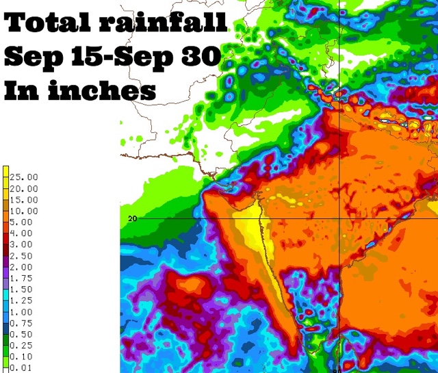
Coastal Maharashtra and the city of Mumbai are in for extremely heavy rains around September 24, 2016. Some forecast models suggest about 25 inches of rain in these places by the end of the month. 

The rest of Maharashtra, south Gujarat, some districts of Saurashtra and north, central Gujarat may also receive 2-5 inches of rain at that time.

This is going to happen because a Bay of Bengal cyclonic circulation will clamber over peninsular India, emerge near the Konkan coast in the Arabian Sea around September 24 and intensify into a well marked low pressure area.

Where will the low pressure system go after that? Hard to say now. Some forecast models say it will weaken and move into northern Maharashtra-western Madhya Pradesh. But this is not certain.

It might well decide to take a stroll in the Arabian Sea.
----
"Latest GFS forecast says the Arabian Sea low pressure system will hit northern Oman on September 29, 2016 with heavy rains."
----
Things are going to happen in the coming days in the Indian west coast. Mumbai. Prepare for floods. The GFS model says heavy showers in Konkan, Mumbai will start much before September 24. In the next few days. Heavy rains are expected in Maharashtra on September 17-18.

Very heavy rains are possible in Mumbai in next 72 hours. This will be just a precursor to the expected deluge on September 24.

Forecast models are predicting a sudden explosion of monsoon activity with two strong low pressure systems developing, one each in the Arabian Sea and Bay of Bengal around September 24, 2016. That day seems to be D-Day. Deluge day.

Situation presently is fluid. So it is hard to say where the rain systems will go. One thing is certain. Some places in South/West Asia are in for a lot of rains in the coming days.


Share this PostPin ThisShare on TumblrShare on Google PlusEmail This

Two Rain Systems Imminent In India

SEPTEMBER  7, 2016, WEDNESDAY 

The monsoons may be at an ebb now but a strong revival is in the offing in the coming 10 days. Many parts of India, Bangladesh and Myanmar may receive heavy rains.

This will be possible because of two low pressure areas. Both will travel a long time without weakening and cross a long distance. 

Let us discuss in detail.

The first is the low pressure/cyclonic circulation that is hovering over Bengal presently. In the coming days it will move along the coast in the Bay of Bengal. First Odisha then Andhra Pradesh. It will enter the state on September 15 and move through Telangana, Maharashtra and emerge in the Arabian Sea just off the Mumbai coast, south of Saurashtra on September 17. Where it will go after that remains to be seen. It may move into Gujarat. Or it may dissipate in the Arabian Sea. Or it may intensify into a depression or tropical cyclone.

Folks in Gujarat, Oman and Pakistan must track this system with interest. Forecast models say it will intensify after emerging in the Arabian Sea.

The second rain maker system will come from the South China Sea. It will be born west of the Philippines, intensify into a depression or tropical storm and hit central Vietnam on September 13, 2016. After that it will move through Cambodia, Myanmar, and emerge in the Bay of Bengal near the Bangladesh/Bengal coast and intensify on September 17, 2016.

What this system does after that is uncertain at this stage.

We are not saying a tropical cyclone is imminent in the North Indian Ocean but if forecast models are to be believed a major rain system is likely in both the Bay of Bengal and the Arabian Sea in the coming days.

Let us see.

UPDATE, SEPTEMBER 8, 2016, THURSDAY 

The picture remains hazy. Further latest data from forecast models confirms a strong low pressure area off the Andhra Pradesh coast on September 18. Also confirmed is the tropical storm/depression hitting central Vietnam on September 13. The CFS model predicts heavy showers in Konkan and Mumbai around September 24, 2016.


Share this PostPin ThisShare on TumblrShare on Google PlusEmail This

FLASH UPDATE: DELUGE IN GUJARAT SOON?

AUGUST 5, 2016, 1100 IST 

Earlier forecast models had been saying the Bay of Bengal low pressure system that is currently moving over Odisha, Chattisgarh would go to Rajasthan via Madhya Pradesh onto flood Delhi Haryana on around August 8, 9.

But latest forecast data from NOAA's GFS model says the system will not go to Rajasthan, Delhi but move to Gujarat.

If this happens a deluge awaits Gujarat from August 7, 2016. 

The GFS predicts very heavy rains in south, central, north Gujarat, Kutch and finally in coastal Sindh in the coming 3-4 days.

We are monitoring the situation and will constantly analyse data to see if this GFS prediction stays unchanged and is confirmed by other forecast models

We will provide constant updates.

UPDATE:AUGUST 5, 2016, 1230 IST 

The other reliable forecast models still insist the system will go to Rajasthan. Who is right? The next 24 hours will tell. We tend to agree with the other models. Let us see.

UPDATE:AUGUST 5, 2016, 1700 IST 

The GFS model in its latest data issued today at 0600 hours GMT still stays firm on its prediction. It says the flooding rain system will hit Central, South Gujarat on Sunday noon Indian Standard Time. One shudders to think of Valsad which is still reeling from flooding, if this monster rain system hits it on August 7.

UPDATE:AUGUST 6, 2016, 0730 IST 

Thankfully for Gujarat, it is now almost certain that the Bay of Bengal system will go towards Rajasthan via Madhya Pradesh. 

UPDATE: AUGUST 6, 2016, 1800 IST 

The GFS in its latest forecast issued today at 0600 hours GMT, says the rainmaker system over Madhya Pradesh presently will move to southern Rajasthan and then slink into north Gujarat area around Tuesday, August 9, and bring heavy rains there. Personally we think it is improbable. The GFS model is prone to make inaccurate forecasts at times.


Parts of Gujarat, especially South Gujarat, and parts of Saurashtra are still reeling from flooding rains from an upper air cyclonic circulation. Meanwhile another system from the Bay of Bengal is moving west. GFS model thinks it will hit Gujarat in 48 hours. The next 24 hours will tell if the nightmare situation will realise or not.


Share this PostPin ThisShare on TumblrShare on Google PlusEmail This

Latest Forecasts/Updates


Popular Posts

Search This Site