Showing posts with label Florida. Show all posts

Future Monster Hurricane MATTHEW May Go Anywhere

SEPTEMBER 29, 2016, THURSDAY 

Tropical storm Matthew slowly moving west in the Carribeans has forecast models pointing at different directions when the future track of this soon to be monster hurricane is concerned.

Yesterday we had hinted it could hit Miami, Florida on October 6-7, 2016. This prediction we had based on the ever reliable European model, ECMWF. Today the ECMWF is predicting a different path. It expects a direct hit on Haiti on October 5, 2016. This model further says that this storm is going to be even stronger than earlier expected. After passing Haiti, it will intensify into a category 4 monster reaching a central minimum pressure of 927 hPa. That means winds in excess of 120 knots. Possibly Bermuda is in for a royal thrashing.

But as we said earlier different forecast models are saying different things. The National Hurricane Center says Cuba is for a rendezvous with Matthew. But it remains silent on where the hurricane will go after that. Head for Florida? Or swing away into North Altlantic Ocean?

The present situation is that it could go anywhere, from states adjoining the Gulf of Mexico (seems unlikely) to a hit on Florida (less unlikely) or sailing away into the Atlantic after giving Haiti or Cuba a good hiding.


UPDATE: SEPTEMBER 30, 2016, FRIDAY

Though the official National Hurricane Center forecast predicts hurricane Matthew will move through Cuba and into the Altlantic, the threat to Florida remains. The reliable ECMWF model foresees a hit on the state. Supporting it is the NHC-LBAR model. Even the GDFL and GDFN models predict a path close to Florida.

This storm has many folks in the weather forecasting community on tenterhooks. The red line is the ECMWF prediction. The white line with red dots is the official NHC forecast.


Share this PostPin ThisShare on TumblrShare on Google PlusEmail This

Category 4 Hurricane MATTHEW May Slam Into Miami, Florida October 7, 2016

SEPTEMBER 28, 2016, WEDNESDAY 

There is a strong likelihood that a category 4 (or 5) hurricane Matthew may hit Florida at Miami on October 7, 2016.

The future tropical cyclone has already formed off the coast of Guyana in the Atlantic Ocean. National Atmospheric and Oceanograhic Administration (NOAA) has started tracking the system. It calls it Invest 97L.

Matthew is going to be a slow moving system. Initially it will hug the South American coast and move along. Heavy rains are likely in the Caribbean islands of Trinidad and Tobago, Saint Vincent and The Grenadines, Grenada, Netherlands Antilles and Aruba in the next few days.

97L will remain a depression till it moves past Aruba on September 30-October 1. Once in the Caribbean Sea it will swing north and start intensifying into a tropical storm. Jamaica will be hit on October 4, 2016, Cuba on October 5, 2016 with winds of 140-160 km/h.

Then on October 6 after hurricane Matthew passes Cuba that it will rapidly intensify into a category 4/5 monster. It is possible that when it hits Florida at Miami wind speeds may well exceed 230 km/h with a central minimum pressure of 938 hPa. Gaston which is the strongest storm recorded in the Atlantic this season was a mere child in comparison.


Share this PostPin ThisShare on TumblrShare on Google PlusEmail This

August 8, 2016: United States Extreme Weather Forecast Update

LAUGUST 8, 2015, MONDAY, 0730 ET

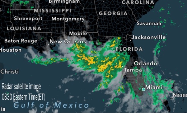
The low pressure area with clusters of thunderstorms lies near the Florida coast in the Gulf of Mexico. It will bring heavy rains to northern coastal areas of the state till Thursday after which the system will move along the coast to Louisiana and then by Monday next, August 15, will move inland into Mississippi, Tennessee, Arkansas and Kentucky bringing heavy precipitation.

Heavy rains in coastal areas near Gainesville, Tallahassee, Lake City till Monday midnight. Continuous, intermittent rain expected in these areas till Friday.

Flooding rains in New Orleans, Baton Rouge, Gulfport on Saturday.

Very heavy rains in Louisiana, Arkansas, Tennessee, Kentucky on August 14,15


Share this PostPin ThisShare on TumblrShare on Google PlusEmail This

Another Little Storm COLIN, Will Hit USA, Florida This Time

JUNE 6, 2016

Tropical storm Colin Florida June 2016
Menacing clouds gather over Florida as Colin approaches. (Image credit:ABC)

After Bonnie, another tropical storm will drench the US east coast. Tropical storm Colin has formed in the Gulf of Mexico and it threatens Florida in next 20 hours.

This storm is small. It's central minimum pressure is 1008. Though by the time it hits the Florida coast by 0000 hours GMT Tuesday it will have dropped to 998 hPa.

The National Hurricane Center estimates its winds to be 65 km/h. By landfall it might rise to 70-80 km/h.

Colin is going to bring heavy rains to Florida. Significant precipitation is also expected in Georgia, South Carolina and North Carolina under the influence of this storm.

Colin is going to be fast moving. By Wednesday it will be in the Atlantic Ocean. It will then turn into a mid latitude tropical cyclone as it moves away into the ocean.

Monsoon to be active soon

Rainfall forecast tropical storm Colin June 2016
Tropical storm Colin will bring heaviest rainfall to northern Florida.

Share this PostPin ThisShare on TumblrShare on Google PlusEmail This

After Boris, Cristina Is Coming. In The Gulf Of Mexico

AMERICAS

Tropical Storm "Crisitina" hitting Florida on June 12, 2014. Heavy rains.

As we write this tropical storm Boris is about to make landfall into central Mexico. Heavy rains and winds will lash the area. But that is not the end of the story. In the next few days southern Mexico will receive heavy precipitation. The remnants of Boris will then move over into the Gulf of Mexico.

And the unsettled system will gain fresh energy from the warm waters there and spawn another tropical storm. Thus Cristina will be born. Within a day or two. I guess the NHC will give the name Cristina to this storm. Or will the name Boris do?

Anyway. The new tropical storm will potter around the Gulf of Mexico and move slowly in a ENE direction gaining strength all the time. On the 11th of June, 2014, Cristina will hit Florida and then start weakening. But in the next two days after that it will bring some rains to North and South Carolina, as well as in Georgia

A current IR image of the disturbed Central America in wake of Boris

The NHC gives a 30% chance today for Cristina developing. That could change.
Share this PostPin ThisShare on TumblrShare on Google PlusEmail This

Tropical Depression Two-e Will Bring Heavy Rains To Central Mexico, Yucatan In Coming Days: To Florida On June 11,2014

AMERICAS

Satellite image of TD-Two-e as seen at 2100 hrs, (UTC) June 2, 2014

Is Tropical Storm Boris coming? May be. May be not. But a deep depression has formed in the Pacific off the coast of Mexico. This system is likely to movie slowly through central Mexico in the next few days bringing very heavy rains there.

After moving into the Gulf of Mexico Two-e is expected to gain strength. It is going to give a deluge to the Yucatan peninsula. The question is will Two-e cross the NHC threshold to become a tropical cyclone; To be christened "Boris"?

Two-e is also going to bring heavy precipitation to Florida on June 11, 2014. It is then expected to weaken and move eastward into the Atlantic Ocean after that.

That is the present forecast. But will Two-e turn bigger and nastier than as is expected now? More importantly, will it stray from the predicted course and hit other states besides Florida?


...TORRENTIAL RAINS EXPECTED OVER PORTIONS OF SOUTHERN MEXICO AS THE DEPRESSION MOVES TOWARD THE COAST

Here is what the storm guru, JTWC, has to say about Two-e.......


Heavy rains hit Florida on June 11, 2014


Current NASA satellite image of tropical storm BORIS

Another view of tropical storm BORIS
Share this PostPin ThisShare on TumblrShare on Google PlusEmail This

Latest Forecasts/Updates


Popular Posts

Search This Site