Showing posts with label flooding. Show all posts

August 8, 2016: United States Extreme Weather Forecast Update

LAUGUST 8, 2015, MONDAY, 0730 ET

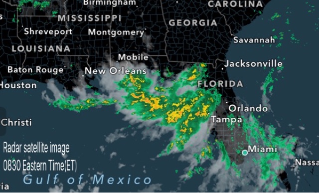
The low pressure area with clusters of thunderstorms lies near the Florida coast in the Gulf of Mexico. It will bring heavy rains to northern coastal areas of the state till Thursday after which the system will move along the coast to Louisiana and then by Monday next, August 15, will move inland into Mississippi, Tennessee, Arkansas and Kentucky bringing heavy precipitation.

Heavy rains in coastal areas near Gainesville, Tallahassee, Lake City till Monday midnight. Continuous, intermittent rain expected in these areas till Friday.

Flooding rains in New Orleans, Baton Rouge, Gulfport on Saturday.

Very heavy rains in Louisiana, Arkansas, Tennessee, Kentucky on August 14,15


Share this PostPin ThisShare on TumblrShare on Google PlusEmail This

Predicted Impact Of Nanauk Cyclone On Oman: Rainfall, Wind, Waves

The severe cyclonic storm Nanauk which is going to hit Oman on Saturday, June 14, 2014 is going to bring torrential rainfall and devastating winds to Oman. We give the forecast of the winds, waves and rainfall expected through XWF prediction maps.

Total accumulated rainfall in Oman till June 16, 2014 owing to cyclone Nanauk. The figures are in inches. It is going to be a deluge. Flooding.

Wind speeds in knots, Purple color is over 50 knots (93 kph). It is expected to be an awesome 150 kph. Destruction is feared.

Waves in meters. 6 to 8 meters high waves will batter coastal Oman. The island towns of Dawwah and Kalban will be worst hit
Share this PostPin ThisShare on TumblrShare on Google PlusEmail This

Latest Forecasts/Updates


Popular Posts

Search This Site
