Showing posts with label october 2014. Show all posts

Hurricane GONZALO Is Battering Bermuda Now: May Reach Britain In A Few Days!


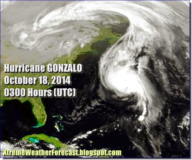
This guy may not be as big and powerful as Katrina but he has stamina. Hurricane Gonzalo which is hammering Bermuda now, may even reach the British Isles , according to the NHC!

That means this storm is going to make a trans-Atlantic trip. Very few storms have done that in recorded history.

The guy is pulverising Bermuda with 185 Kph winds. Newfoundland will get a taste of Gonzalo in a day or two with 100+ kph winds. When it reaches Britain on October 21, 2014, it will still pack winds of 60-115 Kph. Phew!

Hurricane Gonzalo reaches Britain on October 21, 2014


Hurricane Gonzalo Hits Bermuda. NBC Video
Share this PostPin ThisShare on TumblrShare on Google PlusEmail This

Cyclone Hudhud Update: 11/10/2014: Very Strong Winds To Lash Andhra, Odisha And Chattisgarh On Sunday


Cyclone Hudhud is now only a few hundred kilometers from Visakhapatnam. Rains are already lashing coastal districts of Odisha, Andhra and West Bengal.

Now the latest expected wind speed check. Just when the storm is near Vizag, the storm will throw up the strongest winds. 200-250 Kph. This will be early morning on Sunday (12/10/2014).  Come Sunday evening and winds of 165-200 Kph will be howling through the districts of Andhra ( Visakhapatnam, Sri Kakulam, Vijayanagaram and East Godavari), Odisha (Malkangiri, Koraput, Nabarangpur). Even Chattisgarh (Dantewada and Jagdalpur) will experience winds of 120-160 Kph.

And very heavy rain everywhere. Especially in Northern Andhra, southern Orissa and parts of Chattisgarh.

It is a misconception that the storm will weaken rapidly after making landfall. It is a powerful system that is going reach Uttar Pradesh and bring rainfall there.


Share this PostPin ThisShare on TumblrShare on Google PlusEmail This

Typhoon VONGFONG Starts Hammering Small Japanese Islands

Image of Typhoon Vongfong taken at 0900 Hours UTC

The Japanese islands of Okinawa, Osumi and Amami are in for a rough time as Typhoon Vongfong barrels through them. The winds? 200-250 Kph. Okinawa will face the worst winds.

The typhoon will weaken when it makes landfall on mainland Japan at Miyazaki and Kagoshima. Winds of about 150 Kph. Hardly any consolation.

But the winds will further decrease as it moves through the other islands of Japan. Kyoto (October 13, 2014) will be let off with 90 Kph. By the time the storm passes Misawa (October 14, 2014) in northern Japan they will have dropped to 60-70 Kph.

Entire Japan will receive heavy rainfall between October 12-October 14.


Share this PostPin ThisShare on TumblrShare on Google PlusEmail This

Cyclone HUDHUD: Latest Videos

We will keep adding latest videos on this page

 http://xtremeweatherforecast.blogspot.in/2014/10/cyclone-hudhud-latest-videos.html

 Keep in touch.

Cyclone Hudhud. Visakhapatnam (India). October 12, 2014

Share this PostPin ThisShare on TumblrShare on Google PlusEmail This

Cyclone Hudhud Update: MIGHT TURN OUT TO BE A NASTY STORM

The guy was just born; And he is throwing up winds of 55 kph! One can imagine what he will do when he grows up!

Latest satellite image of the system (Hudhud)

We talk here of the upcoming tropical cyclone HUDHUD.

It hasn't even crossed the Andaman islands and is growing in power.

Hudhud is going to be one of those relatively quick-moving storms. Born today. And will slam into the Andhra-Orissa border on October 11-12, 2014. Four-five days flat.

The latest forecast has not changed much from what we said earlier. Only the final destination of the storm remains slightly unclear. Orissa? Andhra? Or on the border between both? (Or is our man going to change his mind again? Cyclones are so darned unpredictable. So Bangladesh, West Bengal. Keep your fingers crossed. At least for the next two three days.

The venerable JTWC will make things more precise then. It just says the "possibility of the development of a significant tropical storm in the next 48 hours is medium."

NOAA is more alert. It has already given a name to the system. 10992014 INVEST.

The cyclone is coming. No doubt about it. Several forecast models confirm the fact.

How intense is it going to be? Present forecasts say it is going to be quite a storm.

A day more. The JTWC will confirm. The IMD will confirm. And both the web and TV airwaves will be saturated with cyclone Hudhud.

Keep in touch for the latest, reliable updates.

Share this PostPin ThisShare on TumblrShare on Google PlusEmail This

Typhoon Vongfong To Hit Okinawa, Osumi, Amami Islands And Kagoshima Head-On October 12, 2014

October 13, 2014. The monster hits southern Japan

Typhoon Vongfong is whipping up winds now at a howling 200 kph. It lies at 17 degrees North, and 135 degrees East. About 500 nautical miles from northern Philippines. It has now starting veering towards Japan. It will not affect the Philippines.

In the next 48 hours it will be at its strongest. A super typhoon. With winds at a whopping 250 kph, with gusts up to 310 kph.

It will hit Japan on the 12th of October, 2014. But it's path will be somewhat similar to that of Phanfone. It will slide along the east Japan coast for the next two days.

But some parts of Japan will be directly hit by Typhoon Vongfong. The islands of Okinawa, Osumi, Kyushu and Amami. The cities of  Kagoshima and Miyazaki will be battered head on by the typhoon on October 12, 2014.

The good news is that the typhoon will weaken quite a lot when it hits the Japanese islands. 150-180 kph winds. It will not be a super typhoon then.

But still, it will pack quite a punch. Something tells me that compared to Vongfong, Phanfone was a saint.

By the way the name "Vongfong" was contributed by Macau. It means a "wasp".

This is how Typhoon Vongfong is going to move in the coming days
Share this PostPin ThisShare on TumblrShare on Google PlusEmail This

UPDATE: LATEST FORECAST SAYS CYCLONE HUDHUD WILL HIT ANDHRA COAST

Earlier we had said that upcoming cyclone Hudhud would make landfall at Orissa on October 11, 2014.

But latest forecasts say Hudhud's target has changed. Instead of Orissa, it is going to be the Andhra coast where the cyclone will strike on October 11, 2014.

Initially the system will remain depression but intensify into a cyclone as it approaches the Andhra coast.

We guess, IMD is not going to honor the storm with a name for a few more days.

Keep in touch for the latest updates.

Share this PostPin ThisShare on TumblrShare on Google PlusEmail This

Future Cyclone HUDHUD Is A Low Pressure East Of Andaman Islands Now

FORECAST MAP: October 8, 2014: Hudhud intensifies after it crosses the Andaman Islands. The eye of the cyclone is clearly seen.

The JTWC says there is a medium chance of a cyclone developing in the low pressure area which hovers in the Bay of Bengal east of the Indian Andaman Islands.

In the next 24 hours the system is going to cross the the Andaman Islands. The Middle Andaman Islands will face the most of the wind and heavy rainfall. The islands will have winds gusting at 70-85 kph.

Now the IMD (Indian Met. Dept.) definition is if a storm has winds in excess of 62 kph it is declared a cyclone. Now following that I guess the IMD should name the system "Hudhud". But I have detected a certain reluctance on the part of the IMD to name a storm. The JTWC in contrast is prompt in christening a tropical storm.

So in a nut shell. The Andaman Islands (including Port Blair) is in for strong winds and heavy precipitation in the next 24 hours as cyclone Hudhud enters manhood from adolescence.

After that in a day or two Hudhud will intensify rapidly as it moves towards the coast of Orissa. The eye of the storm will become visible. Winds will be at around 100 kph.

On October 11, 2014 Hudhud will strike the Orissa coast.

Share this PostPin ThisShare on TumblrShare on Google PlusEmail This

LATEST TYPHOON PHANFONE UPDATE: OCT. 5, 2014: Will Hammer Tokyo Tomorrow With 140 KPH Winds


Typhoon Phanfone will smash into Tokyo tomorrow (Monday, October 6, 2014) noon local time with winds of 140-165 kph. A category 1 or category 2 hurricane according to US standards, but still that is quite a punch. So forget motor racing and Grand Prix.

The southern parts of Japan are already bearing the brunt of the typhoon as it slides along the coast of the country with winds of 185 kph gusting up to a mammoth 225 kph. A category 3 or 4 storm.

Japan has another worry coming up as it deals with typhoon Phanfone. Another typhoon Vongfong has already formed in the Pacific and ready to move towards Japan in the coming days. More about that later.


October 5, 2014. Kagoshima, Japan. Phanfone's fury
Share this PostPin ThisShare on TumblrShare on Google PlusEmail This

Is Tropical Cyclone "HUDHUD" Coming In The Bay Of Bengal Soon?

Cyclone HUDHUD as seen on October 11, 2014

It has become quite hot in many parts of India lately. The temperatures are rising at many places and are expected to be 40 C in a few days.

Such a spell of hot weather in October means something is going to happen. And yes, there is a likelihood that the next storm in the North Indian Ocean is going to be born in a day or two.

Cyclone 'HUDHUD' may be coming soon. In the Bay of Bengal.

Forecasts support this possibility. I have been observing since the last few days that a low pressure was likely to form in the Bay. Only when the models predicted that a storm may be in the offing that I write these words.


The low pressure area in the Bay of Bengal will form tomorrow near the Malaysian coast. The system will then slowly gain strength and move to the east Indian coast for the next few days. By then it will have turned into a tropical cyclone and is expected to hit Orissa on October 12, 2014.

I don't say that Hudhud is going to be another Phanfone but it will be no mean storm.

It is early days and anything can happen.

The name "Hudhud" has been given by Oman. An Arabic word that means "to lull" or "to rock" (a baby to sleep). Cyclone Hudhud is certainly not going to lull anyone to sleep.

Cyclone Hudhud about to touch Orissa on 12/10/2014
Share this PostPin ThisShare on TumblrShare on Google PlusEmail This

LATEST UPDATE: Phanfone Will Batter Eastern Japan Coast For Two Days

Latest satellite image of 'Phanfone' taken at 0300 hrs, GMT, October 4, 2014. The tail is already lashing Japan

Typhoon 'Phanfone is bad news for Japan. As it moves towards Japan it is intensifying (It is already a monster). It is likely to touch southern Japan tomorrow morning (Sunday, October 5, 2014) local time. After that it will slide along the entire east coast of the country for the next 48 hours.

The bad news is the winds (not to talk of the flood bringing rainfall) are not going to abate much. In other words the entire east coast of Japan is in for an unholy hammering.

Meanwhile the next storm 'Vongfong' has already formed and will move towards Japan gradually. It is also going to turn into a big bad storm. Present forecasts say that Vongfong will near the southern Japan coast then abruptly halt for some time. After which it will dis-integrate.

Vongfong is not expected to affect Philippines or Taiwan.

Thank God for little mercies.

But Phanfone is real bad news for Japan. On Sunday-Monday.

FORECAST MAP: :PHANFONE" HITS JAPAN SUNDAY


Share this PostPin ThisShare on TumblrShare on Google PlusEmail This

A Bay Of Bengal Low Pressure Area Will Form On October 8, 2014

The Indian monsoons have been weak this year. Both the Bay of Bengal and the Arabian Sea have been relatively calm as compared to other years. June and September-October are the times of the year when these seas churn out a tropical storm.

Well, the Bay of Bengal is going to throw out a low pressure area this October. The system will form on October 8, 2014 near the Andaman Islands and will, according to present indications, move to the Andhra coast in India and bring heavy rains on October 13, 2014.

It is to be seen if the system turns out bigger (A tropical storm?) or not.


 FORECAST MAP: The low pressure area brings rains to east coast of India on October 13, 2014

FORECAST MAP: The system is formed on October 8, 2014
Share this PostPin ThisShare on TumblrShare on Google PlusEmail This

Western Pacific Update, September 21, 2014: Wung-fong will die down after crossing Taiwan, "Kammuri" Will Hit Japan October 3, 2014

The Atlantic and Indian oceans have been peaceful. In contrast, the Pacific, especially Western Pacific is in ferment.

Tropical storm Fung-wong is moving intoTaiwan now. It will cross through it bringing rains and gale. The storm will than make landfall in China's Zhejiang province and will peter out, bringing rains to South Korea and Japan.

The next storm, "Kammuri" will form deep in the Pacific by September 25. It will strengthen and move west initially but then turn north sharply and hit central Japan on October 3, 2014.


Typhoon Fung-wong will move into Taiwan tomorrow . A weak storm.


An infra-red satellite image of Typhoon Fung-wong taken at 0000 Hrs, September 21, 2014 (GMT)


Fung-wong is entering Taiwan

READ MORE ON TYPHOON FUNG-WONG
Share this PostPin ThisShare on TumblrShare on Google PlusEmail This

Latest Forecasts/Updates


Popular Posts

Search This Site