Showing posts with label #CycloneHudhud. Show all posts

Hudhud Will Burn Itself Out By October 15, 2014: Where Will It Go?


The once powerful Cyclone Hudhud will die without a whimper by October 15, 2014. It is already weakening fast, shorn of its energy source, the Bay of Bengal. But before it peters out, it will bring quite heavy rainfall in northern Andhra, parts of Odisha, Chattisgarh, Maharashtra, Madhya Pradesh, Uttar Pradesh and even a segment of North Bihar.

Phew!

By tomorrow morning it will be a depression. By 14th it will be a low pressure area. By late 15th it will be history.


The power of Cyclone Hudhud. October 12, 2014
Share this PostPin ThisShare on TumblrShare on Google PlusEmail This

HUDHUD UPDATE: 160 Plus Winds Will Batter Andhra, Parts Of Odisha Till Monday Morning

Image: IBT

Right now the rest of the cyclone Hudhud is passing through Visakhapatnam now. For the next 12 hours, it will batter Andhra Pradesh (Visakhapatnam, Vijayanagaram, Srikakulam, East Godavari) and Odisha (Koraput, Malkangiri, Nabarangpur, Nauparha, Rayagada, Kalahandi) with 150 + Kph winds.

Only in the next two three days after the storm passes over, the extent of the destruction that it has left in it's wake will become evident.

One fears that this is going to be massive.

One gets the nagging feeling that the administration and people were not fully aware of what was going to hit them. That is why we had yesterday we had stressed ("Is The National Media Fast Asleep?") on the heedless attitude of the national TV media. If they had jumped into the fray earlier, may be the awareness of the coming danger would have been much more. The relentless pressure from the incessant live reporting by the national media would have goaded on the state government (especially Andhra) to be on their toes.
Share this PostPin ThisShare on TumblrShare on Google PlusEmail This

Cyclone Hudhud Images


It is raining heavily in Andhra, Odisha, Chattisgarh and West Bengal

It is raining heavily in Odisha, Andhra and parts of Chattisgarh now. The winds are howling through Vizag as the cyclone passes through the city.


Share this PostPin ThisShare on TumblrShare on Google PlusEmail This

Cyclone Hudhud Update: 11:00 AM: 12/10/2014: The Eye Is Crossing Into Andhra Now


The eye of Cyclone Hudhud is crossing into the Andhra coast right now  (Near Vijayanagaram). The eye of the storm is the center of the storm, an area of diameter of 30 Kms. In the eye of the storm is a deceptive area of calm, with no winds, no rains; Lulling one to believe that the storm has past. But soon it starts all over again, as the other half of the cyclone starts crossing. More strong winds, heavy rains again.

Winds of 175 Kph will be experienced till 6:00 PM (IST) today evening (Sunday) in the Andhra districts of Srikakulam, Vijayanagaram and Visakhapatnam. In Orissa, Koraput will be hard hit.

According to the Indian Navy, the maximum winds felt at Visakhapatnam were around 200 Kph.

Expect another 6-8 hours of strong winds (lower than before, as the storm will start weakening) and heavy rains.

Winds of 150+ Kph Still expected till 6:00 PM (IST) in Visakhapatanm and nearby areas.


Share this PostPin ThisShare on TumblrShare on Google PlusEmail This

Cyclone Hudhud Update 8:30 AM,12/10/2014: WARNING! IN A FEW HOURS: 175-210 KPH WINDS TO HIT VISAKHAPATNAM


Cyclone Hudhud is just a few hours from making landfall. Ground Zero will be Vijayanagaram and Srikakulam coast. The winds will be 175 Kph, gusting up to 210 Kph.The devastation is going to be massive. Because these kinds of winds are going to howl on for about 12 hours.

A TV channel met some coastal residents near Vizag who were wide awake throughout the night. When asked they said they had never heard such winds before and they were frightened.

The good news is that the storm is weakening slightly. At 5:30 in the morning it was at its peak, throwing up winds of 200-250 Kph when it was a few kilometers away.

The Andhra districts of Srikaulam, Vijayanagaram and Visakhapatnam will bear the brunt of Hudhud's fury. So will Malkangiri district of Odisha.


#CycloneHudhud makes landfall Raw Video
Share this PostPin ThisShare on TumblrShare on Google PlusEmail This

Latest Cyclone Hudhud Update: 4:00 PM, 11/10/2014.The Monster Is At The Doorstep. Is The Indian Media Fast Asleep?


Is the Indian media sleeping? I mean specifically the electronic media. Instead of giving live coverage of the evacuation work going on in Andhra and Orissa and creating a sense of much needed urgency about the big threat that looms from the sea, all they are doing is showing election campaigning, Saturday afternoon soap serial gossip or other leisure shows shown on normal weekends.

But this is not a normal weekend. Massive cyclone Hudhud is hours away. And no one (Media, general public) seems to care. Pathetic.

Folks, we can do much better.

The threat is real and close. The cyclone Hudhud is hardly a couple hundred kilometers from the shore and is INTENSIFYING. Today midnight when it will be treading for Visakhpatnam's door, it will be at its strongest. 200 KPH, gusting up to 260 KPH.

And when it hits Visakhapatnam tomorrow morning, it will have subsided only slightly. 195-250 KPH winds. Some relief!

The Indian Met. Dept. has recognised the threat and is giving repeated warnings that the storm should not be taken lightly.

NOW IS THE TIME THAT THE MEDIA AND THE GENERAL PUBLIC IS MADE WELL AWARE OF THE LOOMING DANGER. ANDHRA AND ORISSA IS AS MUCH INDIA AS SAY MAHARASHTRA, KARNATAKA OR ASSAM ARE.

The wind speed forecast given by the JTWC. Note that that the "KTS" in the table is Knots and not Kph. 1 Knot=1.852 Kph
Share this PostPin ThisShare on TumblrShare on Google PlusEmail This

Latest Image of Cyclone Hudhud From NASA


Share this PostPin ThisShare on TumblrShare on Google PlusEmail This

Cyclone Hudhud Update: 11/10/2014: Very Strong Winds To Lash Andhra, Odisha And Chattisgarh On Sunday


Cyclone Hudhud is now only a few hundred kilometers from Visakhapatnam. Rains are already lashing coastal districts of Odisha, Andhra and West Bengal.

Now the latest expected wind speed check. Just when the storm is near Vizag, the storm will throw up the strongest winds. 200-250 Kph. This will be early morning on Sunday (12/10/2014).  Come Sunday evening and winds of 165-200 Kph will be howling through the districts of Andhra ( Visakhapatnam, Sri Kakulam, Vijayanagaram and East Godavari), Odisha (Malkangiri, Koraput, Nabarangpur). Even Chattisgarh (Dantewada and Jagdalpur) will experience winds of 120-160 Kph.

And very heavy rain everywhere. Especially in Northern Andhra, southern Orissa and parts of Chattisgarh.

It is a misconception that the storm will weaken rapidly after making landfall. It is a powerful system that is going reach Uttar Pradesh and bring rainfall there.


Share this PostPin ThisShare on TumblrShare on Google PlusEmail This

Latest Cyclone Hudhud Update: Will Enter Visakhapatnam, Saturday Midnight, 11/10/2014 With 200 KPH Winds


Latest forecasts from the JTWC says that cyclone Hudhud will touch the Indian Andhra coast at midnight Saturday, October 11, 2014 with winds of 200 Kph, gusting up to 250 Kph.

The JTWC in its latest bulletin issued at 8:00 AM today says it is going to intensify rapidly and make landfall at Visakhapatnam on Sunday morning.

"FAVORABLE UPPER-LEVEL CONDITIONS ARE EXPECTED IMPROVE, ALLOWING TC 03B TO STEADILY INTENSIFY PRIOR TO LANDFALL NEAR VISAKHAPATNAM."

There is no doubt that the storm is going to hit the Andhra coast at Visakhapatnam. Odisha can take a sigh of relief. But some districts of the state will experience the strong winds of the cyclone. Entire Odisha will receive heavy rains in the next three days.We have dealt with how and where the storm will  affect the most in an earlier article.


Share this PostPin ThisShare on TumblrShare on Google PlusEmail This

CYCLONE HUDHUD UPDATE: How And Where Will It Affect India: Winds, Rainfall And Wave Surge


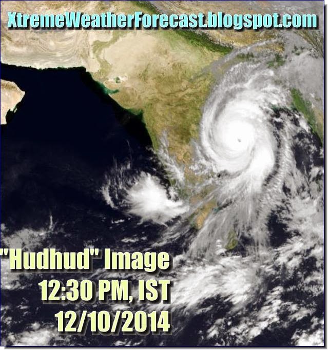
Latest forecasts say that Cyclone Hudhud is going to make landfall near Visakhapatnam on late Saturday evening. Though the winds will slightly less than feared earlier, they will be very strong. At time of impact the winds be around 190 Kph, gusting up to 230 Kph.

Another feature of this storm is that even after moving into India the winds will not subside suddenly. Even some districts of Chattisgarh will face winds of 60-80 Kph. Not to mention that heavy downpours.

Cyclone Hudhud is going to bring heavy rainfall to many parts of India. Odisha, Seemandhra, West Bengal, Chattisgarh, parts of Madhya Pradesh, Maharashtra and Uttar Pradesh.

The worst affected (Wind, rainfall) districts will be as follows,

ANDHRA: East Godavari, Visakhapatnam, Vijayanagaram, Srikakulam, Khammam
CHATTISGARH: Sukma, Dantewada, Bijapur, Bastar, Narayanpur.
ODISHA: Malkangiri, Koraput, Gajapati, Rayagada, Kalahandi, Nabarangpur

Waves Will Cause Sea To Enter Land For Kilometers

It happened during the 1999 super cyclone. It happened during Phailin. And it will happen within the next few days courtesy Cyclone Hudhud. Sea entering the coastal areas. Hudhud is going to whip up waves up to 12 meters along the coast at time of impact. So sea water will rush in inland, especially into low lying areas along the coast. Worst affected will be Visakhapatnam.

That is why the disaster authorities are evacuating people who live close to the coast.

Rainfall Forecast Map: Cyclone Hudhud is going to bring a lot rain to India (Map shows total precipitation till 17/10/2014)


Share this PostPin ThisShare on TumblrShare on Google PlusEmail This

LATEST PREDICTED PATH TRACK OF CYCLONE HUDHUD (UPDATED REGULARLY)


Latest predicted path/track of Cyclone Hudhud according to JTWC (Updated 12/10/2014, 9:00 AM, IST)


Share this PostPin ThisShare on TumblrShare on Google PlusEmail This

Cyclone HUDHUD UPDATE: Vital Misconceptions In Media: It is going to be Northern Andhra (Vizag) NOT Odisha


WE would like to point out some dangerous misconceptions that the media is spreading. Not only Indian media but the international media too. About Cyclone Hudhud.

FIRST: Many media sites are saying (including BBC) that cyclone Hudhud is going to strike the  Odisha coast at Gopal-at-Sea on October 12, 2014. This is wrong. The JTWC (Their forecasts are always accurate) says the storm is going to hit the Andhra coast near Visakhapatnam AND NOT Odisha. The distance between Gopal-at-Sea and Visakhapatnam is about 300 Kilometers. In disaster planning and preparedness this can make a hell of a difference.


SECOND: The BBC says winds, when the storm makes landfall, will be about 175 Kph. The JTWC in contrast (We agree with them) in its latest bulletin says the winds when Hudhud makes landfall on Saturday evening is going to be 220 Kph , GUSTING UP TO 260 kph. BBC bases its forecasts on Met Office (UK). Now the JTWC predictions are any day more trustworthy than that of the Met Office.

THIRD: Most media, including the BBC and IMD say that the cyclone is going to make landfall on Sunday (October 12, 2014) morning. The JTWC says the storm will hit the Andhra coast on Saturday evening. Just 50 hours left.

We think the confusion should be cleared at the earliest. The Andhra and Chattisgarh (It is going to see very heavy rains) governments should spring into action at the earliest (Just as the Odisha government is at maximum alert).

The danger is to Northern Andhra and Chattisgarh is as much as it is to Odisha (if not more).

People, please wake up. There are just 48 hours left.


Share this PostPin ThisShare on TumblrShare on Google PlusEmail This

CYCLONE HUDHUD LATEST UPDATE: A MONSTER, A CATEGORY 4 HURRICANE: VIZAG TO SEE 240 KPH WINDS SATURDAY EVE

Satellite image Of Cyclone HUDHUD taken today (9/10/2014) at 5:30 AM (IST)

Cyclone Hudhud is already whipping winds of 80 Kph. And it is going to rapidly  intensify further. in the next few hours. It is now 700 Kms from Visakhapatnam.

We had said that Hudhud would be no Vongfong. We were wrong. This storm will turn out to be a monster. With winds when it hits Visakhapatnam on Saturday late evening will be over 200 Kph. The IMD will call it a "Very Severe Cyclonic Storm". According to the Saffir-Simpson Scale Hudhud will be a Category 4 storm.

Cyclone Hudhud (According to predictions now) will be just short of a Super Cyclone. Hudhud is going to be as bad (If not worse than) as Phailin.

Ground Zero will be the towns of ELAMANCHILI and ANAKAPALLE just south of Vizag

When it hits the Indian shores near Visakhapatnam on Saturday evening (Local Time) the winds will be 215 Kph, gusting up to a whopping 260 Kph.

A word of advice to folks living on the Andhra-Orissa border coast. Run. And now. The storm is going to come on Saturday evening (October 11, 2014).

Latest Forecast Track Path of Cyclone Hudhud (9/10/2014)


NASA image of Ground Zero. This where Cyclone Hudhud is going to come in two days

Expected Path-Track of Cyclone Hudhud
Share this PostPin ThisShare on TumblrShare on Google PlusEmail This

Cyclone Hudhud Will Bring Heavy Rains To Andhra And Orissa : Oct. 10-13, 2014

Cyclone Hudhud will not only bring powerful winds, but very heavy rainfall. Not only to Andhra (Visakhapatnam is Ground Zero) but also Orissa, West Bengal, Madhya Pradesh and Chattisgarh (And Even Uttar Pradesh).

The rains will start from October 10, 2014. Friday. And will continue for the next three days. Seemandhra of course will see most of the flooding. But Orissa will also receive heavy rains from Saturday to Monday.

There will be floods in these two states.

Rainfall Forecast Map Owing to Cyclone Hudhud


The map shows the amount of rainfall that Cyclone Hudhud will bring from Today till Sunday, October 12, 2014
Share this PostPin ThisShare on TumblrShare on Google PlusEmail This

Latest Cyclone Hudhud Update: TARGET VISAKHAPATNAM, SUNDAY MORNING, OCTOBER 12, 2014. WINDS 150 KPH PLUS

Satellite Image of Cyclone Hudhud taken at 2:30 PM (IST), Today (8/10/2014)

The target of intensifying Cyclone Hudhud has changed slightly. It was earlier the Andhra-Odisha border at Dharmavaram. Now latest forecasts say the cyclone is going to hit Visakhapatnam head-on on October 12, 2014, Sunday morning. The winds then will be a howling 150 KPH, gusting up to a massive 185 KPH.

The effects will be felt in Pondicherry in the south and Bhubaneshwar in  the north. But Vizag will face the brunt of the storm as the center of the storm is going to pass through it.

#CycloneHudhud is going to be a big storm. Just when it will be a few hundred kilometers from the coast (On Saturday, October 11, 2014) it will whip up winds of 175-225 Kph.But at the time of impact on Vizag, mercifully, the winds will have reduced to a 150-185 Kph.

The Americans would say it is a Category 2 tropical storm. Nothing to sneeze at.

Satellite image of the area around Visakhapatnam. The storm is coming.
Share this PostPin ThisShare on TumblrShare on Google PlusEmail This

Cyclone HUDHUD: Latest Videos

We will keep adding latest videos on this page

 http://xtremeweatherforecast.blogspot.in/2014/10/cyclone-hudhud-latest-videos.html

 Keep in touch.

Cyclone Hudhud. Visakhapatnam (India). October 12, 2014

Share this PostPin ThisShare on TumblrShare on Google PlusEmail This

JTWC Confirms Cyclone HUDHUD Will Hit Indian Caost North Of Visakhapatnam With 150-180 kph Winds

The US Navy's JTWC  (Joint Typhoon Warning Center) has confirmed that cyclone Hudhud will hit the Indian coast on the Odisha-Andhra Border (at Dharmavaram) on Sunday morning (October 12, 2014) IST.

The winds when the cyclone makes landfall will be 150 kph gusting up to 185 kph. Quite a big storm.

The JTWC calls it Tropical "Cyclone" 3B now


The JTWC says in its 8:30 AM (IST) Bulletin....
TROPICAL CYCLONE (TC) 03B (THREE), LOCATED APPROXIMATELY 589 NM SOUTH
OF CHITTAGONG, BANGLADESH, HAS TRACKED WEST-NORTHWESTWARD AT 12 
KNOTS OVER THE PAST SIX HOURS.

The JTWC has already called it a "Tropical Cyclone" 3B. When is the IMD going to name it "Hudhud"? When?


Share this PostPin ThisShare on TumblrShare on Google PlusEmail This

Cyclone HUDHUD Update: Will Grow Into A Full Blown Cyclone On Thursday (8 October, 2014) Afternoon: Target: DHARMAVARAM (AP)


Satellite Infra-red Image of Tropical Depression 3B (Cyclone Hudhud) taken today morning at 04300 hours (IST)

The present Tropical Depression 3B is now crossing the central Andaman Island. By tomorrow afternoon (Thursday, October 9, 2014) IST, it will have strengthened into Cyclone Hudhud with winds in excess of 85 kph.

Right now the storm is drenching "Kaal Paani" with winds of about 55-60 kph. It will intensify further in the coming 30 hours. It will then start moving in  a NW direction.

When it approaches the Orissa coast on Friday evening, it will suddenly intensify further and grow into a bigger storm. Winds of about 120 kph. It will enter the Odisha coast at Gopal-at-Sea (Berhampur) on the night of Saturday (11 October, 2014).

Let me make one thing clear. Hudhud is not going to be another 1999 super cyclone. Nor will it be a Katrina or Vongfong. But it is going to be a significant storm.

The Orissa government has rightly geared into action from now. The Andhra government too should be prepared as the northern districts of the state are going to be affected on Saturday night-Sunday afternoon.

The Andhra government should start preparations on a war footing as there are chances that Ground Zero might shift from Gopal-at-Sea to Visakhapatnam.

NOAA forecasts warn that when Hudhud makes landfall at DHARMAVARAM (Andhra pradesh) between Gopal-at-Sea and Visakhapatnam the wind speeds will be 150 kph. The storm is going to rapidly intensify before hitting the Indian coast on Saturday night.
Share this PostPin ThisShare on TumblrShare on Google PlusEmail This

Cyclone Hudhud Will Hit Orissa Coast At Gopalpur-At-Sea (Berhampur) On October 11, 2014

Satellite Image of Tropical depression 19B (Future Cyclone Hudhud) taken at 8:30 PM (IST)

LATEST FORECAST UPDATE: OCTOBER 7, 2014: 9:30 PM IST

Cyclone Hudhud is going to form soon. It is called Tropical depression 19B presently. Contrary to earlier expectations it will initially be a weak storm. It is only when it nears the Andhra-Orisaa border coast (Gopalpur-at-Sea, Berhampur) that it will intensify rapidly and turn into a big cyclone. The landfall is expected to be on October 11-12, 2014.

Projected Path and Intensity of Cyclone According To Met Office

 TROPICAL DEPRESSION 99B        ANALYSED POSITION : 11.4N  94.6E


  VERIFYING TIME     POSITION     STRENGTH        TENDENCY

  --------------     --------     --------        --------

 00UTC 07.10.2014  11.4N  94.6E     WEAK

 12UTC 07.10.2014  11.9N  93.6E     WEAK        LITTLE CHANGE

 00UTC 08.10.2014  12.7N  92.4E   MODERATE      LITTLE CHANGE

 12UTC 08.10.2014  13.3N  91.0E   MODERATE      LITTLE CHANGE

 00UTC 09.10.2014  14.1N  89.8E   MODERATE      LITTLE CHANGE

 12UTC 09.10.2014  14.9N  89.0E   MODERATE  INTENSIFYING SLIGHTLY

 00UTC 10.10.2014  15.7N  88.1E   MODERATE  INTENSIFYING SLIGHTLY

 12UTC 10.10.2014  16.8N  87.1E    STRONG   INTENSIFYING SLIGHTLY

 00UTC 11.10.2014  17.5N  86.4E   INTENSE   INTENSIFYING RAPIDLY

 12UTC 11.10.2014  18.1N  84.8E   INTENSE   INTENSIFYING RAPIDLY

 00UTC 12.10.2014  18.1N  83.2E    STRONG     WEAKENING RAPIDLY

 12UTC 12.10.2014  18.7N  81.6E   MODERATE    WEAKENING RAPIDLY

 00UTC 13.10.2014  19.6N  80.1E   MODERATE      LITTLE CHANGE


JTWC Bulletin On Cyclone Hudhud: 7:00 PM October 7, 2014


MAXIMUM SUSTAINED SURFACE WINDS ARE ESTIMATED AT 25 TO 30 KNOTS. MINIMUM SEA LEVEL PRESSURE IS ESTIMATED TO BE NEAR 1000 MB. THE POTENTIAL FOR THE DEVELOPMENT OF A SIGNIFICANT TROPICAL CYCLONE WITHIN THE NEXT 24 HOURS IS HIGH.
Share this PostPin ThisShare on TumblrShare on Google PlusEmail This

Cyclone Hudhud Update: MIGHT TURN OUT TO BE A NASTY STORM

The guy was just born; And he is throwing up winds of 55 kph! One can imagine what he will do when he grows up!

Latest satellite image of the system (Hudhud)

We talk here of the upcoming tropical cyclone HUDHUD.

It hasn't even crossed the Andaman islands and is growing in power.

Hudhud is going to be one of those relatively quick-moving storms. Born today. And will slam into the Andhra-Orissa border on October 11-12, 2014. Four-five days flat.

The latest forecast has not changed much from what we said earlier. Only the final destination of the storm remains slightly unclear. Orissa? Andhra? Or on the border between both? (Or is our man going to change his mind again? Cyclones are so darned unpredictable. So Bangladesh, West Bengal. Keep your fingers crossed. At least for the next two three days.

The venerable JTWC will make things more precise then. It just says the "possibility of the development of a significant tropical storm in the next 48 hours is medium."

NOAA is more alert. It has already given a name to the system. 10992014 INVEST.

The cyclone is coming. No doubt about it. Several forecast models confirm the fact.

How intense is it going to be? Present forecasts say it is going to be quite a storm.

A day more. The JTWC will confirm. The IMD will confirm. And both the web and TV airwaves will be saturated with cyclone Hudhud.

Keep in touch for the latest, reliable updates.

Share this PostPin ThisShare on TumblrShare on Google PlusEmail This

Latest Forecasts/Updates


Popular Posts

Search This Site