Showing posts with label Madagascar. Show all posts

Cyclone FANTALA April 2016: Latest Updates


FINAL UPDATE:APRIL 21, 2016

Within 24 hours the weakening tropical cyclone will again move course roughly westward and pass the northern tip of Madagascar on April 24/25. There is little chance of it threatening Mauritius in any way.
The infrared image of the storm was taken at 0200 hours GMT today.


UPDATE: APRIL 20, 2016

Cyclone Fantala is steadily weakening and will continue to do so. It is now moving ESE. After a few days it will drift back in a WNW direction, passing the northern tip of Madagascar on April 25. It may then fizzle out mid sea or bring rainfall to the Tanzania-Mozambique border coast later. The only land area it may affect is Saint Brandon, the little isle north of Mauritius.

Interestingly forecast models are hinting at a new tropical storm in the southern Indian Ocean around April 25. This possibility is supported by NOAA in its fortnightly outlook (See map below)


UPDATE: APRIL 19, 2016

After becoming the strongest tropical cyclone recorded in the Indian Ocean (North and Southern) on April 18 with one minute sustained winds of 275 km/h, FANTALA is now weakening and moving in a southeasterly direction.

It will move so till April 23 after which it will again change direction and move west. It will hit the northern tip of Madagascar on April 25/26 as a tropical storm.

Going by present forecasts, the threat to Mauritius and Rodrigues seems to be receding.

Satellite image cyclone Fantala April 19 0330 GMT
Fantala is weakening as the latest satellite image ( April 19, 0300 hours GMT) shows

Latest track forecast cyclone Fantala April 19
Latest track forecast for Fantala


UPDATE: APRIL 17, 2016

Fantala is presently a furious storm, with 240 km/h winds according to the Joint Typhoon Warning Center. It lies about 1100 kilometres NW of Mauritius.

Reliable forecast models now agree that within 24-48 hours the cyclone will swing southeasterly. It may pass between Mauritius and Rodrigues on April 23, 2016. A direct hit on Rodrigues is not ruled out.

The cyclone is expected to weaken considerably in the coming days after April 19.

Tropical cyclone Fantala satellite image 0730 GMT April 17
Satellite image 0730 hours GMT, April 17, 2016

----

UPDATE APRIL 16, 2016. 

Even reliable forecast models are giving erratic predictions at every update. There is a possibility that cyclone Fantala might hover around about 500 kilometres NW of Mauritius for a week then weaken and make landfall into northeastern Madagascar.

But we still believe that the storm will swing southeasterly on April 19 and hit Rodrigues island on 22-23rd.

Meanwhile Fantala has intensified into a category 4 hurricane with winds that the JTWC expects to touch a whopping 130 knots (240 km/h). It presently lies about 800 kilometres north of Mauritius.

TRACK FORECAST ISSUED TODAY 

----

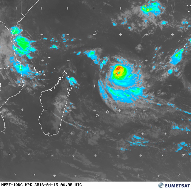
UPDATE APRIL 15, 2016 - There is little change in the forecast scenario since yesterday. Fantala will continue west till April 18 as a category 3 hurricane and then swing down and move southeasterly henceforth. A direct hit on Rodrigues is possible on April 22, 2016. But by then the cyclone will have weakened considerably to a category 1 or maybe just a tropical storm.


MPE IMAGE OF CYCLONE FANTALA APRIL 15, 2016. 0600 HOURS GMT 

----

UPDATE APRIL 14, 2016 - Fantala is well on its way in turning into a category 4 monster hurricane soon as it moves west. Track forecasts indicate a abrupt change in direction on April 17-18. It will weaken slightly and move southeasterly. It is to be seen if it moves betwixt Mauritius and Rodrigues or hits Rodrigues directly. This will happen on April 21.


Cyclone Fantala infrared image April 14 southern Indian ocean
INFRARED IMAGE APRIL 14, 2016 TROPICAL CYCLONE FANTALA 0200 GMT 

----
Update April 13, 2016 - All forecast models agree on Fantala's future for the next 4 days. It will move westerly in the Southern Indian Ocean, intensifying all the time and reach the northernmost tip of Madagascar. The European model ECMWF, envisages it attaining a central pressure of 945 Mb. A category 5 hurricane.

Then from April 17-18 it will abruptly change direction and move southeasterly and move between Mauritius and Rodrigues Island on April 21. It will have weakened quite a bit by then. This part of the forecast is prone to change. A little shift and a direct hit on either Mauritius or Rodrigues will happen


----

Update: April 12, 2016 - Cyclone Fantala has formed. It lies about 650 kilometres south of Diego Garcia and is moving west. It will continue doing so for the next 3-4 days and then will abruptly change direction and move south or south-easterly. Present forecasts say it will hit Rodrigues Island on April 20 but Mauritius cannot be deemed safe as the forecast track has been changing all the time.

Satellite image cyclone Fantala April 12, 2016

----
Update: April 11, 2016 - The cyclone is presently a low pressure area south of Diego Garcia. It is strengthening all the time. Our guess is it will become a tropical cyclone by April 14. As to its track, the picture is nebulous. But forecast models at present are predicting that it will pass by Mauritius/Rodrigues Island around April 20.
----
We have already warned on our Twitter page about a possible tropical cyclone brewing in the southern Indian Ocean in the coming days. We had also said the cyclone Fantala was unlikely to affect Mauritius, La Reunion islands.

But recent forecasts by reliable computer forecast models hint at the possibility of Fantala turning into a massive 946 Mb storm which will hover near the northeastern coast of Madagascar by April 17, 2016.

History says any tropical cyclone in that area tends to move south or southeasterly. Hence the possibility of Fantala hitting Mauritius or La Reunion is quite strong. The GFS model envisages a massive monster hitting the isle nation.

It is also possible that the storm may move through the northern tip of Madagascar and crash into Mozambique or southern coastal Tanzania. The ECMWF model supports this scenario.

The forecast image shows the cyclone's position on April 17.

Cyclone Fantala Southern Indian Ocean Mauritius
Latest satellite images of cyclone Fantala 
Share this PostPin ThisShare on TumblrShare on Google PlusEmail This

XWF-WEATHER FORECAST SUMMARY: January 3, 2015: Cyclone Lam And Linda Imminent In Australia Around January 10, 2015

Update: January 3, 2015

Upcoming Cyclone Lam And Linda

Within 24 hours future tropical cyclone Lam will be born as a low pressure area in the Timor Sea in South-Eastern Indian Ocean. The storm will struggle to intensify into something bigger because of the unfavourable wind shear. But around January 10 it will manage to turn into a cyclone. Lam. It is expected to make landfall between Broome and Onslow in Western Australia and move right through the territory. On January 13 it will exit from the Australian land mass at Great Victorian Desert and Nullarbor Plains. The entire province of Western Australian will receive rains.

Another cyclone is expected to form almost simultaneously in the Arafura Sea or Gulf of Carpentaria around January 10, 2015. So it hard to say which of the storms will be Lam and Linda. The one in Western Australia or the one in Queensland? Now this storm will make landfall at Karumba in Queensland. It will then  move across the province and move into Pacific Ocean on January 12 between Mackay and Rockhampton. It will then move close along the coast for a day and swing away towards New Zealand. Brisbane will get a lashing from the storm on January 13. New Zealand may face a cyclone on January 14, 2015.

It is also possible that a storm may come from Papua New Guinea and hit the Queensland coast on January 10 near Townsville.

There are many complex factors at play so being 100% certain is difficult but it is certain that a cyclone is coming Australia's way soon. When? Where? We have outlined the possibilities.

See a tropical storm developing near Australia. LIVE.

South Western Indian Ocean

Presently a depression is moving around in circles in the Mozambique Channel. It will continue doing so for a few days more without strengthening into a storm. The conditions are not favouring it. Strong wind shear is preventing it to move away from its present area. So it is zigzagging around bringing lots of rains in coastal Mozambique and Madagascar.

Come January 14, 2015 and the South Western Indian Ocean may throw up two cyclones. One in the Mozambique Channel and one near Mascarene Islands. The former will make landfall into Mozambique around January 17-18. At the same time the second storm will move through Rodrigues Island and then move further south. So Rodrigues Island is in for a direct hit. Mauritius and La Reunion will feel the periphery of the cyclone.

Seems like Cyclones Bansi and Chedza are coming calling in mid January, 2015.
Share this PostPin ThisShare on TumblrShare on Google PlusEmail This

A Vigorous Southern Indian Ocean May Throw Out A Couple Of Big Cyclones In Next 15 Days: Lam Coming To Australia

Update: December 30, 2014

Mother Earth May be hurtling blizzards and Arctic blasts in North Asia, Europe and North America but when it comes to the tropics, the Southern Indian Ocean reigns supreme. This active ocean already has a category 3 hurricane 'Kate' hurtling down south. In the next fifteen days it may engender two more tropical cyclones. Especially tropical cyclone 'Lam' which is expected to hit the western coast of Australia in early January, 2015.

Even as Kate will be in her death throes on January 2, 2015, another storm will come into being in the Mozambique Channel. This storm already exists as a low hugging the Afrian coast. In the next two days it will start intensifying and move around southern Madagascar. This storm may remain a deep depression, possibly a borderline cyclone.  Though this will not move north towards the Mascareignes, another depression (A potential cyclone) will come visiting the area on January 7, 2015. This depression now lies as a 'low' some hundred kilometers SW of Diego Garcia presently.

What is more interesting is the possibility of a big bad cyclone hitting western Australia in early January. Cyclone Lam will form on January 6, 2015 off the coast of North-West Australia between Broome and Karratha. Lam is going to be a big storm. Central pressure of 973 Mb. Exmouth will be badly hit with winds of 150 kph. The storm will not make landfall but move along the west coast of the country. Geraldton and Perth will too be affected.

That is not all. On January 12 a low pressure area will form north of Mauritius and will then start intensifying rapidly. Mauritius and La Reunion can expect a big cyclone on January 15-16.

Share this PostPin ThisShare on TumblrShare on Google PlusEmail This

Post Kate, South Indian Ocean May Spawn Two (Three?) Cyclones: North West Australia To Face "Lam".

Update: December 29, 2014


The South Indian Ocean is gonna give birth to two more tropical cyclones, Bansi and Lam in the coming days, post-Kate. Australia may face its first cyclone this season. There is also some indication that another cyclone might come visiting to the Mascareignes in mid-January.

The ocean is most vigorous right now. The mighty Pacific could only throw up a weak Jangmi, in contrast the Indian Ocean is throwing out fistful of storms. Even the northern Indian Ocean gave rise to a depression 95B in mid winter. The Southern part has a energetic Cyclone Kate moving down south whipping up sustained winds of 125 kph.

The ocean has more in store for us. Two more cyclones in the coming week. Bansi and Lam. Targets? Madagascar and North-West Australia.

Cyclone Bansi will come first. It will be born as a low pressure in the Mozambique Channel, the strip of Indian Ocean between the African mainland and the island of Madagascar. It will born in the next 24 hours. It will remian an innocuous low pressure for some time  like any of the numerous "L" that bob around the ocean. But come January 4, 2015 and it will start intensifying. It will then move round southern Madagascar (An intelligent storm???) and enter South West Indian Ocean proper. And intensify into Tropical Cyclone Bansi by January 8. Bansi will be a storm with a central pressure of 994 Mb, something like Kate. It is not expected to move north towards Reunion or Mauritius but move south into the powerful westerlies.

Cyclone Lam  This will be born off the coast of North-West Australia (Near Broome) on January 4, 2015. It will then toddle around in that part of south east Indian ocean, intensifying all the while. Lam is gonna be bigger than Bansi. Central Pressure of 989 Mb. This storm is going to make landfall near the Australian town of Exmouth and Barrow Island on January 10, 2014.

It is still early days. So one can hardly be certain of the intensity and path the upcoming cyclone is gonna take.

Parting Tidbit

Around January 14, 2015, Mauritius and La Reunion may have a tropical cyclone as an unwanted guest. If early model forecasts available with XWF-WEATHER are to be believed this is going to be a nasty storm which will come over from northern Madagascar. May be 'Chedza' will follow 'Bansi' soon this January.
Share this PostPin ThisShare on TumblrShare on Google PlusEmail This

Latest Forecasts/Updates


Popular Posts

Search This Site