Showing posts with label MAARUTHA. Show all posts

Cyclone MAARUTHA Hurtling Towards Myanmar

UPDATE, APRIL 17, 2017

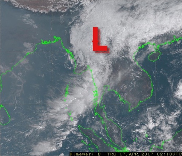
The cyclone made landfall near Sandoway around midnight and moved inland. Latest satellite image shows the system has weakened to a low and is over interior Myanmar now.


UPDATE APRIL 16, 2017, 1530 IST 

Presently tropical cyclone MAARUTHA lies about 150 kilometres from the Myanmar coast. It is raining very heavily in Rakhine state around Sandoway. Our estimate is it will make landfall at 2300 hours, Myanmar local time.

The pink color denotes areas of very heavy rainfall.

APRIL 16, 2017, SUNDAY 

The deep depression in the Bay of Bengal intensified further into tropical cyclone MAARUTHA last night. Current wind speeds of the storm are 65-70 km/h. It lies presently about 300 kilometres from the coast of Myanmar.

By early Monday morning it will make landfall into the country's coast between Sittwe and Sangoway near Ramree and Cheduba islands. Wind speed at impact will be 75 km/h. There will be flooding rainfall in that part of Rakhine state. Though precipitation has already started in many parts of coastal Myanmar.

Capital Naypyidaw will receive heavy thundershowers by noon tomorrow as the weakening system moves inland.

The Joint Typhoon Warning Center predicts MAARUTHA will hit the Myanmar coast at midnight with winds of 65-70 km/h. Our estimate is they will be higher.




Share this PostPin ThisShare on TumblrShare on Google PlusEmail This

Tropical Storm, MAARUTHA, To Form April 15

APRIL 14, 2017

The low pressure area that has formed in the Bay of Bengal lay a few hundred kilometres east of the coast of Tamil Nadu today early morning. It was throwing out winds of 35-40 km/h then.

It is intensifying all the time and moving quickly in a northerly direction away from the Indian mainland. The American GFS model expects it to turn into a tropical storm by Saturday morning when it will be close to the Andaman Islands. This model expects it to reach wind speeds of 120 km/h when it hits the Myanmar coast at Rakhine, south of Sittwe on Monday morning.

Other models too expect a Rakhine landfall on April 17 but they expect the system may remain just a deep depression, not a tropical cyclone, reaching sustained winds of 60 km/h.

But it is going to bring very heavy rainfall to Andaman Islands and in Myanmar by April 20, 2017.

Latest data from the GFS model says MAARUTHA is going to intensify into a 150-170 km/h monster with a central minimum pressure of 957 hPa before landfall into Myanmar in the early hours of Monday. Very worrying news for the authorities and people of the country.

Bay of Bengal depression April 2017

Share this PostPin ThisShare on TumblrShare on Google PlusEmail This

Bay of Bengal Storm (MAARUTHA) To Hit Myanmar April 17-18, 2017

APRIL 13, 2017, THURSDAY 

The expected deep depression/tropical cyclone MAARUTHA in the Bay of Bengal will be spawned as a low pressure area today a few hundred kilometres east of the Sri Lankan coast. Forecast models say it will go on ultimately and hit the coast of Myanmar at Sandoway on April 17-18, 2017.

This system will intensify rapidly after forming today evening, Indian Standard Time, IST. It will move rapidly in a north northeasterly direction, strengthening all the time. It will move past Andaman Islands in the next 48-72 hours. By Saturday it will turn into full blown tropical storm.

It remains to be seen if the IMD (Indian Meteorological Department) deems it fit to be a tropical cyclone MAARUTHA or labels it just a deep depression. Our estimate is that the system will be throwing out sustained winds of 65-75 km/h by April 16. A tropical cyclone.

The storm will weaken into a depression before landfall into the Rakhine state of Myanmar near Sandoway on April 18, 2017. It will bring heavy rains to Andaman and Nicobar islands and Myanmar in the coming days. Our estimate is at least 8-10 inches of torrential precipitation.

American GFS model predicts a stronger storm. It envisages the system moving more quickly and hitting Myanmar south of Sittwe on April 16. Thus leaving even less time for authorities in Myanmar to prepare for this imminent quick moving threat. The country's disaster relief personnel should swing into action at the earliest to take preemptive measures to mitigate the losses.

Our advice to tourists in the Andaman and Nicobar islands is to go to nearby storm shelters or leave for the mainland earliest possible. The weather is going to be very nasty in the coming days.

Probable position of Bay of Bengal storm on April 16, 2017.
Disturbed conditions in Bay of Bengal presently. The yellow and red dots denote lightning. The dark blue color shows heavy precipitation.
Total accumulated rainfall till April 22, 2017
Share this PostPin ThisShare on TumblrShare on Google PlusEmail This

Bay of Bengal Depression/Tropical Cyclone Is Being Born

APRIL 12, 2017

A low pressure area is being gradually formed in the Bay of Bengal. A look at the latest satellite image of the sea reveals massive clusters of disturbed weather and powerful thunderstorms. From this morass of clouds will emerge a rain system between Nicobar islands and the Indian mainland.

Global forecast models are divided over whether this low will intensify into a deep depression or tropical cyclone MAARUTHA. The American GFS is clear in portending a cyclone. It predicts a tropical storm nudging along the Myanmar coast bringing a deluge to these areas.

Other models expect a deep depression or a weak tropical storm to form in the next 48-72 hours. The system will move north northeasterly and head for the border of northern coastal Myanmar and Chittagong region of Bangladesh. 

Whatever happens, Indian Andaman and Nicobar islands are in for a deluge in the coming days. Upto a metre of rainfall may occur. Tourists visiting these islands are advised to head to safer areas or leave for mainland India as soon as possible as the weather in the Bay of Bengal is going to be very disturbed in the next coming 5-7 days.

Disappointingly for drought hit Tamil Nadu the present expected storm system will not give it the much needed rain, though Sri Lanka will experience heavy showers under its influence.

Rains will come to Tamil Nadu by the end of this month, but it will be owing to another system.

The pink denotes areas of very heavy rainfall presently.


Share this PostPin ThisShare on TumblrShare on Google PlusEmail This

Cyclone MAARUTHA Imminent In Bay of Bengal?

APRIL 11, 2017

Something like this was bound to happen, given the searing abnormal temperatures in many parts of India. It is possible that we may see the Bay of Bengal spawn a powerful tropical cyclone by April 14-15, 2017. It will be named MAARUTHA.

Major global weather forecast models are suggesting that a low pressure area will form in the Bay of Bengal west of the Andaman Islands in the next 3-4 days.


The American GFS model says outright that this system will intensify into a powerful cyclone by April 17-18. At present it says the storm will go on and hit the northern coast of Myanmar just south of Chittagong around April 20.

Other models are more sanguine. They do predict a big depression/tropical storm but are not sure about its track. They say it will weaken into a low pressure system by April 18-19.

There is a strong possibility that the system will intensify at most into a deep depression, just short of a tropical storm.

We have to wait and see if MAARUTHA does form. And if yes, where it goes finally.

Windy torrential rainfall of 10-20 inches is expected in Andaman Islands in the coming days due to the influence of this system. And if it hits northern Myanmar expect floods in that part of the country.


Share this PostPin ThisShare on TumblrShare on Google PlusEmail This

Latest Forecasts/Updates


Popular Posts

Search This Site