Weather Outlook For India, South Asia, Middle East In Early June 2016

I

MAY 31, 2016

The picture remains hazy with little agreement amongst major NWP models. But from what we gathered, two areas will be of interest in India, concerning monsoons. One is western India, Mumbai, Arabian Sea coastal areas and Gujarat. The second is Andhra Pradesh.

In both these regions there is a possibility of vigorous monsoon activity in early June.
WESTERN INDIA

The GFS still persists with an Arabian Sea trough bringing heavy precipitation to western India around June 10-13, 2016. Heavy pre-monsoon showers may occur in Mumbai on June 5-6. Drought hit Vidarbha will receive heavy rains on June 8-9.

Coastal Karnataka will get drenched on June 4 because of a rain-bearing trough in the Arabian Sea.

The monsoon onset in Mumbai will occur on June 12, 2016 with flooding rains. All because of the Arabian Sea trough which will form in a few days.

After Mumbai, the monsoons will hit Gujarat on June 14.

ANDHRA PRADESH 

The European model foresees an upper air cyclonic circulation over the Andhra coast near Visakhapatnam on June 6-7. It will bring good rains to Andhra Pradesh and Telangana from June 7 onwards. 

It might so happen that we might be staring at a depression on the Andhra Pradesh coast on June 7. Not a mere cyclonic circulation, but even may be tropical cyclone KYANT. Too early to say now.

We continuously analyse weather charts and will keep you informed of developments.

SOUTH CHINA SEA

Another interesting possible development could be the first typhoon in the Western Pacific Ocean in 2016. There is a strong likelihood of typhoon NEPARTAK forming in the South China Sea around June 10. It could strongly affect Taiwan and eastern coast of Japan.
Share this PostPin ThisShare on TumblrShare on Google PlusEmail This

Monsoons Will Arrive In Mumbai, Gujarat By June 12, 2016

Image credit: Deccan Chronicle 

MAY 30, 2016

The South West Monsoon will arrive in Mumbai and parts of Gujarat around June 10, 2016. With a bang. With flooding rains.

Konkan coast, Mumbai city, South Gujarat and Saurashtra will receive very heavy rainfall from June 10 onwards.

This will be possible because of an off shore trough that will form in the Arabian Sea off the western coast of India in the first week of June.

There will be very good precipitation in southeastern Rajasthan and western Madhya Pradesh on June 13-14 as the low will move over these regions. It could even reach Delhi by June 14-15, bringing heavy showers in the capital.

Mumbai and Maharashtra along with northern Karnataka will receive good pre-monsoon showers between June 4-6.

Lately there have been apprehensions about monsoon 2016 after the Indian Meteorological Department said that the onset in Kerala could be delayed. The searing heat waves in the country along with drought like conditions has most people yearning for the rain gods.

Most climate forecast models and the IMD have predicted a good monsoon this year.

The present tardiness on the part of monsoons is because of the lingering after effects of the now deceased El Niño. Absence of the Madden Julian Oscillation and a negative Indian Ocean Dipole has made things worse.

But as La Niña regenerates by July, the rainfall outlook for India will dramatically improve. Experts are warning of flooding rains in July-October as La Niña goes on the rampage.

RELATED

Share this PostPin ThisShare on TumblrShare on Google PlusEmail This

Tropical Storm BONNIE Will Affect South Carolina, North Carolina, Virginia Till Friday

The first Atlantic Ocean storm this summer hovers off the coast of South Carolina.  In the next 12 hours it will make landfall into the state.

Forecast models say it will intensify slightly after landfall. It will then move through the two Carolinas for another 72 hours. By Wednesday, June 1, 2016, it will exit North Carolina and slip back into the Atlantic.

It will move along the Virginia coast till June 3 then move away from the coast, back into the Atlantic.

The wind will not be too much of a problem. I mean compared to the recent Bay of Bengal tropical cyclone ROANU, BONNIE is a little girl. ROANU at its peak had thrown out winds of 120+ km/h winds. Bonnie boasts of about 65-70.

The problem will be the incessant rainfall this storm will bring to South Carolina, North Carolina and Virginia in the coming 4-5 days. Even West Virginia, Maryland and Delaware might feel the "rain effect".

Tropical storm BONNIE rainfall forecast
Total precipitation till June 3, 2016. Bonnie will bring rains to many states.


Track forecast tropical storm Bonnie May 2016
Track forecast by various models for tropical storm BONNIE.


Share this PostPin ThisShare on TumblrShare on Google PlusEmail This

Rainfall Forecast Till May 30, 2016, In South Asia

MAY 29, 2016

Below is the rainfall forecast map for India, Pakistan, Bangladesh and Oman. It is valid till May 30, 2016, 1800 GMT. In other words, where will it rain in the next 48 hours?

Bangladesh will receive the heaviest falls. More than 5 inches in some parts. So will isolated parts in Sri Lanka.

Indian north eastern states too will record 1-2 inches. Especially in some parts of Assam and Tripura. More than 1 inch expected in Kerala. Karnataka and Telangana too will receive showers. 

Isolated showers in rest of the country except the northwest of India.

Rainfall forecast India May 30 2016

Share this PostPin ThisShare on TumblrShare on Google PlusEmail This

Heavy Rains Possible In Mumbai, Gujarat On June 10, 2016

MAY 29, 2016
XTREME WEATHER POSSIBILITY 

It is quite possible that heavy to very heavy rains may lash Mumbai and parts of Gujarat around June 10-12, 2016. Forecast models hint at flooding rains something in the range of 5-6 inches.

This will be possible because of increasing stormy monsoon activity in the West Indian Ocean near the Somalia coast which all numerical weather prediction models say will happen in early June.

This stormy system will throw out  a trough that will gradually migrate to the Indian west coast by June 10.

It is possible the circulation may linger over the Mumbai-Gujarat area for 4-5 days hence flooding could occur in many places.

There are still more than 10 days to go, but it is a real possibility. We shall track the forecasts and keep you updated. At the earliest.

Monsoon To Hit Mumbai On June 10, 2016

Monsoon rain Mumbai Gujarat June 2016

Share this PostPin ThisShare on TumblrShare on Google PlusEmail This

Indian Monsoon Rains To Be Subdued Till June 15, 2016

MAY 29, 2016

Top medium range forecaster, IITM, Pune, (Indian Institute of Tropical Meteorology) says in its latest analysis that Indian monsoon rainfall activity will remain below normal in the next 20 days.

It also rules out any real possibility of a tropical cyclone developing in either the Arabian Sea or Bay of Bengal in the same period. But it does say there is a good chance of a typhoon in the South China Sea in the coming days.

Tropical cyclone possibilities Arabian Sea Bay of Bengal May June 2016
N
Share this PostPin ThisShare on TumblrShare on Google PlusEmail This

Indian Monsoon 2016 To Rev Up In Early June

MAY 28, 2016

Mumbai will receive upto 4-5 inches of rain by June 12, 2016. Hardly a sign of a delayed weak monsoon. Though the Indian Meteorological Department has warned that the onset over Kerala might be delayed, global forecast models say though monsoon activity may be subdued in the last days of May, things will begin to change by June 5.

Monsoon will gather momentum as it will clamber up the Indian west coast. Mumbai will receive its first heavy showers around June 10, 2016.

By that time rainfall will intensify over the states of Kerala, Karnataka, Andhra Pradesh, southern Maharashtra and Telangana. 

Gujarat will start receiving increased pre-monsoon showers. As will Madhya Pradesh. In fact looking at the rain forecast map below only Rajasthan will remain dry by June 13, 2016.

One can say that rainfall activity is going to accelerate in the second week of June.

Rainfall forecast map monsoon 2016 till June 13
The rain forecast map above shows the total precipitation from now till June 13, 2016. The figures are in inches.

India annual average rainfall map
Above map shows the average monsoon rainfall received by different regions of India.

Monsoon advance progress May 27, 2016
Above map shows the progress of monsoon 2016 till May 27.
Share this PostPin ThisShare on TumblrShare on Google PlusEmail This

Heat Wave In India To Abate By May End


MAY 22, 2016


The maximum temperatures in many parts of India rose to frightening levels. It started with parts of eastern India. Odisha was badly affected. But cyclone ROANU has brought relief.


Gujarat had Ahmedabad touching 48 degrees centigrade on May 19, 2016. But the onset of monsoon winds from the Arabian Sea has cooled Gujarat.


But Rajasthan, Vidarbha and Madhya Pradesh are still steaming. Churu and Ganganagar in Rajasthan registered 49.2 degrees yesterday.


But the Indian Institute of Tropical Meteorology, Pune has good news. It says.....


Day maximum & night minimum temperatures are likely to remain markedly above normal over entire northwest, west & central India during 17th – 26th May. They are likely to fall to their respective normal / below normal values during the period 27th May – 1st June.


What is the reason for this record high temperatures? Meteorologists and climate scientists will have a field day analysing. But ask the ordinary guy on the street. "Global warming", he/she replies promptly.


There, you got the answer.


What to do to beat the killer heat?


Avoid going out in the sun as much as possible. Use a white cap, handkerchief to cover your head. Wear white cotton clothes.


Drink lots of cool water. 22 glasses of water a day.


Bathing in cool water twice a day is a good idea.


Drink buttermilk, lemonade, fruit juices.


Eat watermelon.


Some say eating onions is a good way to beat the heat.


Eat light food. Avoid spicy, oily food.


Drinking glucose/Electral which has sodium, potassium to deal with dehydration.


Given below is the forecast till the end of the month. Heat wave conditions will ameliorate in most parts of India except Jammu and Kashmir and Himachal Pradesh. Sadly heat will return to Odisha, Gangetic West Bengal and parts of Andhra. The temporary healing effects of ROANU will wear off by then.


Interestingly along with western India temperature has dramatically dropped in Muscat too. It had been hovering in the upper 40s during the last few days. Today it dropped to 41 degrees centigrade. The temperature will not go to the highs of the past few days. It will hover around 40 degrees centigrade.


Heat wave warning issued by the Indian Met for today.


Share this PostPin ThisShare on TumblrShare on Google PlusEmail This

Extreme Weather, Monsoon, Cyclone Possibilities May (20-31) 2016 Updates

MAY 28, 2016
ITS RAINING IN KARNATAKA NOW, 1730 HRS IST

Satellite image reveals very heavy downpour in Karnataka, near Bangalore and Mysore. Also at Tiruppur. Showers also in coastal Andhra.


MAY 28, 2016
ITS RAINING CATS AND DOGS IN ANDHRA NOW
Highlight of today is the localised heavy rainfall in Visakhapatnam district of Andhra Pradesh since today morning. It has been raining heavily in the area for hours. This is because of an upper air cyclonic circulation over the area. This is going to hover around Telangana, Chattisgarh and Andhra Pradesh bringing localised thunderstorms.

Also the map below the satellite image shows where and how much (inches) will it rain till today, May 28, midnight IST 

Heavy rainfall Andhra Pradesh May 28 2016


MAY 27, 2016
MONSOON MAY BE FURTHER DELAYED IN JUNE

MONSOON MAY BE FURTHER DELAYED 

The IITM (Indian Institute of Tropical Meteorology) suspects that the onset of monsoon along the Kerala coast may not happen even during June 5 to 10 despite some of the pieces of the jigsaw puzzle falling into place by then.

It remains to be seen if, as is being forecast by some models, a cyclonic circulation potentially taking shape off the Konkan coast and moving away generally towards Oman could prove the disruptor.

Other likely disruptive features include a cyclone (typhoon) each being forecast to erupt over the West Indian Ocean and the North-West Pacific during this week and the next.

From BUSINESSLINE (http://goo.gl/uBCfUA)

MAY 27, 2016
GLOBAL EFFECTS OF EL NINO, LA NIÑA 

El Niño died this May. It had been strong since two years. And India suffered as a result. It had two consecutive lousy monsoons in 2014, 2015.

The maps show the effects of the two phenomena. Hopefully with La Niña on the ascendancy, India will have a good monsoon in 2016.


MAY 27, 2016
BAD MAN EL NINO IS DEAD. MONSOONS WILL ENVIGORATE IN JULY 

Good riddance to El Niño. Most international climate agencies say it is dead. They also say La Niña, the fairy godmother for a good monsoon is making a comeback.

But the ill effects of ENSO, El Niño Southern Oscillation, will be felt on monsoon rains till June. Rainfall activity will be curbed as a result. We talked of the dismal CFS forecast till June 22 yesterday.

But once La Niña gets going there may be flooding rains from July till October in India, Pakistan and even the Middle East (Oman, UAE) as a monsoon spillover effect. Long live La Niña!

The CPC diagram shows the dead of El Niño and the rise of La Niña.

El Niño La Niña forecast Indian monsoon 2016


MAY 26, 2016
CFS HAS WORRYING NEWS ABOUT MONSOON RAINS TILL JUNE 22, 2016

Just a glance at the latest weekly rainfall forecast from May 25 to June 22, 2016 by the CFS model gives us reason to be gloomy. Most of India barring some areas is expected to receive below average rainfall.

Forecasts by western climate forecast agencies and the Indian Met. has led us to expect a bumper monsoon this year. Well, the start at least is going to be inauspicious if one looks at CFS data.

In the forecast maps for next four weeks the green color denotes above average rainfall. The ominous orange color shows below average rains. The white color denotes average precipitation at the place at this time of the year.

Looking at the maps we gather that barring Gujarat, Bihar, Uttarakhand, North Eastern states, some parts of Karnataka, Maharashtra and Uttar Pradesh there will be poor rainfall. The rain deficit is particularly high in western and southern India especially Kerala.

What is even gloomier is that both the Arabian Sea and Bay of Bengal show vast stretches of orange. Meaning rainfall activity is poor even in the seas.

Hope we have bumper July rains. Or a drenching depression or two would be welcome (There is a possibility of a depression near the Andhra coast on June 4).

Rains in June are expected to be poor. They are expected to dramatically rise in July-August as the good effects of the unlamented demise of El Niño start kicking in.

Monsoon prediction May 2016 rainfall


Rainfall monsoon forecast June 2016


MAY 26, 2016
GFS INDICATES TWO STORM POSSIBILITIES AROUND JUNE 10

The first is a depression affecting southern China on the Hong Kong-Hainan coast in the South China Sea. Later GFS data says it's going to be a full blown tropical cyclone (Typhoon NEPARTAK) that may smash through Taiwan on June 10-11, 2016.

The second is a ominous strengthening circulation in the central Arabian Sea at the same time. That is June 10.

Mind you these are just possibilities at present.


MAY 25, 2016
WHY ARE NO CYCLONES FORMING NOW?

We wonder. The time is ripe. Pre- monsoon period. There is an upper air circulation in central Arabian Sea. Why is it not transforming into a tropical cyclone? (Latest GFS data hints at a depression hitting Andhra Pradesh coast on June 7, 2016).

The answer is because of MJO, MADDEN JULIAN OSCILLATION. At the time of ROANU the MJO was passing through eastern Indian Ocean. Presently it is around Indonesia and withering away.

The MJO gives impetus to existing stormy conditions and favours cyclone formation.

Madden Julian Oscillation forecast May June 2016


MAY 25, 2016
RAINS WILL GRADUALLY MOVE INTO INDIA 

Not with a bang engined by a tropical depression or cyclone but gradually. Kerala is already experiencing showers. By month end Mumbai and Gujarat will receive light rainfall. Kerala, Karnataka and southern Andhra will be the wettest in the near future.

For Kerala the IMD warns.....
HEAVY RAINFALL WARNING: Heavy rainfall is most likely to occur at one or two places in Kerala from 27th May 2016 till the morning of 29th May 2016.
27th May:  Heavy rain is likely at isolated places over coastal Karnataka and Kerala.28th May : Heavy rain is likely at isolated places over coastal Karnataka and Kerala.


MAY 24, 2016
RAINS COMING TO INDIAN WEST COAST

The monsoons are slowly building up in the Arabian Sea. There is a lot of instability which will spread in the coming days and bring rains to Kerala. By May 28 rainfall activity will increase in coastal Kerala and Karnataka as the Arabian Sea will push in precipitation.

Analysis of forecast data reveals both the Bay of Bengal and Arabian Sea will remain very unstable. This always happens prior to the onset of monsoons. Numerous upper level circulations will develop.

Some models are hinting at cyclone KYANT developing in the Bay of Bengal around June 1. But it is too premature to take it seriously.

Anything is possible in the coming few weeks. We are closely observing and will keep you posted of significant developments.

Below is a map showing total precipitation (in inches) till May 28, 2016. 

Rainfall forecast India May 28


MAY 23, 2016
IT ALL STARTS FROM HERE.....

Just look at the latest satellite image of central Arabian Sea below. There is an intense cluster of thunderstorms. An oasis in a rainless sea. This system over the next few days will move east to the Indian coast.

Rains in Kerala will start. Then consolidate. They will then spread to coastal Karnataka. The entire sea will be full of rain systems by end of May.

It is from these expanding area of thunderstorms that the GFS forecast model expects a depression or cyclone will be spawned in early June.

Whether that happens or not remains to be seen.


MAY 23, 2016
GFS SHOWS ARABIAN SEA CYCLONE ON JUNE 7. 2016

The Global Forecast System in its 1800 UTC yesterday's data is indicating a big cyclone just south of the Gujarat coast on June 7, 2016.

Let us see if this prediction sustains. It expects the storm to start off as a low pressure area on June 4 near Karnataka coast.

Latest GFS data shows only a low pressure area on May 8.

The prediction by the GFS will have to sustain itself if we are to take it with any seriousness. Moreover it should be supported by other models.

The European model hints at a low forming on the Odisha coast on May 29.

Confusing state of affairs.

We shall watch the situation.


MAY 22, 2016
CFS MODEL PREDICTS HEAVY RAINS ON COASTAL MAHARASHTRA, GUJARAT BY JUNE 5

Most forecast models are not predicting extreme weather events in the coming few days for South Asia and Middle East. But the CFS has some cheering news. It predicts a heavy rain system bringing precipitation to coasts of western India and Sindh between May 29 and June 6.

It predicts upto 6 inches of rain in some places of Maharashtra and Gujarat. And about an inch or two in Gujarat and coastal Sindh. See the forecast map below.

The CFS forecast is supported by the GFS ensemble forecast. See the map below.

The map has some disappointing news too. If we believe this forecast then the map shows very weak below normal monsoon activity elsewhere. See the rampant orange colour? It means below average rains. The IMD has already warned of delayed onset of monsoon this year.

CFS rain prediction Gujarat Maharashtra May June 2016


MAY 22, 2016
MONSOON ACTIVITY WILL RISE DRAMATICALLY BY JUNE 7, 2017

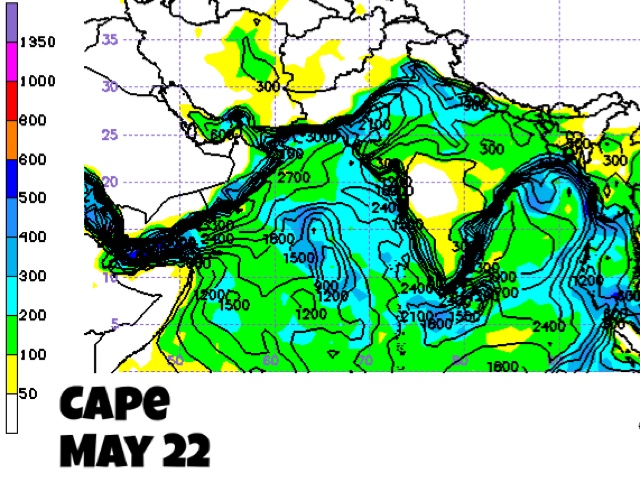
In meteorology one way to know thunderstorm activity is CAPE, Convective Available Potential Energy. Higher the CAPE, greater the instability in the atmosphere. If the atmosphere is unstable, thunderstorms arise, rain happens.

Given below are CAPE maps of today and June 7, 2016. There is a dramatic increase in CAPE.

One sees great atmosphere instability (CAPE) not only in India, Pakistan but along the Oman coast , Gulf of Oman and Bay of Bengal. Only Indian southern states will have tranquil weather.

One can conclude that a lot is going to happen in the next 15 days.

The maps are based on GFS Ensemble model.


MAY 21, 2016

These clusters of thunderstorms in the Arabian Sea as shown in the latest IR satellite image need to be watched.

In the following days these will slowly move east and bring rains to the Indian west coast.


MAY 21, 2016
GFS SHOWS STORM FORMATION OFF MUMBAI JUNE 6

The latest GFS data shows a depression forming on June 6, 2016, in the Arabian Sea off the Mumbai coast. 15 days is a long long time in weather forecasting.

Let us see if the prediction sticks.

The BRAMS (Brazilian Regional Atmospheric Modelling System) model predicts a low forming in the Arabian Sea by May end, but we have our doubts about the veracity of this model.

Storm prediction GFS model Arabian Sea June 6


MAY 21, 2016
HEAVY RAINS EXPECTED ON INDIAN WEST COAST BY JUNE 4

Though NWP models do not foresee any significant storm developing in the Arabian Sea in the coming days, rainfall activity will increase substantially in the sea.

This will be because of the pre-monsoon activity. Call it whatever you will. The fact is rains are coming on India's west coast.

It will be particularly heavy in coastal Kerala and Karnataka. 30 inches of rain by June 4. The map below shows the total accumulated precipitation till June 4, 2016. The data is from NOAA's GFS forecast model. The yellow colour denotes heaviest rainfall.

Rain forecast map May 21

Cyclone possibilities may 27
The IMD sees a good chance of an Arabian Sea cyclone on May 27, 2016.


MAY 20, 2016
CFS MODEL PREDICTS RAINS ON INDIAN WEST COAST BY MAY END

One is not very sure of the reliability of this forecast by the Coupled Forecast System. But it foresees a heavy rain system moving north along the coast in the Arabian Sea and bringing rains to (coastal areas of) Kerala, Karnataka, Maharashtra and Gujarat by May 31, 2016.


MAY 20, 2016

The Indian Meteorological Department, IMD, thinks there is 30+% chance of a tropical cyclone developing in the Arabian Sea in the coming week, especially on May 25, 2016. Off the Gujarat coast.

Latest GFS data indicate a growing clusters of intense thunderstorms in central Arabian Sea by May 25, 2016. But none of the forecast models are hinting at a storm presently.

Arabian Sea tropical cyclone possibilities may 2016

Share this PostPin ThisShare on TumblrShare on Google PlusEmail This

BAY OF BENGAL DEPRESSION TO BRING HEAVY RAINS TO TAMIL NADU: ROANU COMING?

MAY 15, 2016

The low pressure area which has formed off the southeastern coast of Sri Lanka (Termed 91B by NOAA) will intensify soon into a depression and move into Tamil Nadu soon.

Under it's effects the state will witness heavy widespread rainfall for the next 48 hours till Tuesday, May 18. The rains will be accompanied by winds of 50-60 km/h.

The system may then move into the Bay of Bengal and hit coastal areas of Myanmar and Bangladesh by May 21. The system will intensify further on moving into the sea into a deep depression or even a moderate tropical cyclone, ROANU, on May 22.

It is also possible that cyclone ROANU may hit Bangladesh proper on May 24 and not Myanmar. If this happens windy rainfall is possible on the Odisha, West Bengal coast on May 23, 2016.

Some numerical forecast models suggest the system will meander around Tamil Nadu, Kerala, Karnataka, Telangana and Andhra Pradesh for the next 3-4 days drenching these states thoroughly.

The MPE satellite image taken at 0530 GMT shows heavy rainfall in Sri Lanka presently. These rains will move into Tamil Nadu by early tomorrow.

Bay of Bengal Storm Updates

Depression/Tropical Storm possible in Arabian Sea soon

There is a good possibility that a storm system will develop in the Arabian Sea in the coming one week. It is likely to bring rains to western India, Pakistan or Oman. We mention Oman because Arabian Sea storms have had a tendency to veer off towards Oman in recent years.


Share this PostPin ThisShare on TumblrShare on Google PlusEmail This

Rains To Advance Rapidly Into Indian West Coast By May End

MAY 15, 2016

EARLY MONSOONS

Rainfall activity is going to increase dramatically on India's west coast by the end of May, 2016.

Call it monsoon rains or pre-monsoon rains. We leave the technicality to the met department. But monsoon winds are going to advance rapidly up the west coast in the next 15 days. 

Knocking on the doors of Mumbai in 15 days.

How will this happen?

Firstly the present Bay of Bengal low pressure off the Tamil Nadu coast is going to push the rains into Kerala, Tamil Nadu, Karnataka, Andhra Pradesh. Perhaps right into the Indian northeast, Myanmar and Bangladesh.

So 91B is going to engine the monsoons into southern and eastern India. Or create favourable conditions for its onset.

Next the Arabian Sea branch will become active. Though it is uncertain if a storm system will develop or not, clusters of rain systems are expected to advance from southwest Arabian Sea into the Malabar coast. This is according to NOAA's GFS model forecast.

See the rainfall map below. It shows the expected accumulated precipitation by May 31, 2016. We see the Indian coast drenched with more than 25 inches of rain by month end. The yellow colors on the map.

Bay of Bengal Storm Updates


Monsoon rainfall May 2016
Share this PostPin ThisShare on TumblrShare on Google PlusEmail This

Bay of Bengal Cyclone ROANU Updates May 2016

MAY 22, 2016
ROANU NOW A DEPRESSION, OVER MYANMAR

Cyclone Roanu is a cyclone no more. It weakened to a deep depression and then into a depression. Soon it will weaken into a low pressure area.

At 0000 GMT today it lay over Myanmar adjoining to the Manipur border. It will bring heavy rains in north east Myanmar in the coming days.

The whole region will receive rains in the next 72 hours. See the forecast map showing expected precipitation till May 25. Northern Myanmar is in for heavy rains in the coming days as the low moves over the area.


MAY 21, 2016, 0830 GMT 
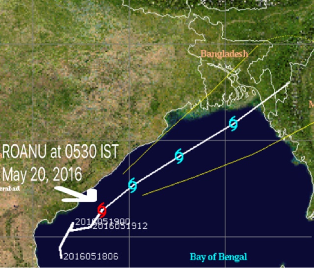
ROANU MAKES LANDFALL EARLIER AT BARISAL AT 0530 GMT 

The cyclone moved into Bangladesh earlier than expected. It took a slightly northerly course than was generally expected. It is moving between Dhaka and Chittagong into Tripura-Mizoram.

It is raining now in southeastern Bangladesh, parts of Myanmar, Tripura, Mizoram and Manipur. The rains will cease in the next 24-48 hours in these areas as the system moves on quickly and weakens into a low pressure area.

But strong winds are blowing on the southeastern Bangladesh coast. Our conservative estimate is 70-80 km/h.

This radar image  at 1100 GMT today shows the rains have already moved onto Mizoram and Tripura.

Rain radar image ROANU


Tropical cyclone ROANU track May 2016


MAY 21, 2016, 0200 UTC, 0730 IST 
ROANU WILL MAKE LANDFALL BY AFTERNOON 

Presently it lies south of the West Bengal coast. Winds of 100 km/h, gusting up to 120 km/h.

It will hit the Bangladesh coastline at Chittagong at about 0800 GMT, that is 1400 local time. Winds of 70-80 km/h will lash southeast Bangladesh.

It is already raining heavily in southern Bangladesh. This will continue for another 24 hours. Heavy rains also expected in Mizoram, Manipur, Tripura and northern Myanmar.

Looking at the latest  Rain Estimator satellite image one sees heaviest precipitation is in northern Myanmar, Indian north eastern states and southeastern Bangladesh.

At 0830 Bangladesh time, the system lay just south of the country's coast at Kuakata.

The storm brought significant rainfall to coastal West Bengal. 93 mm in Contai, 103 mm in Digha and 70 mm in Canning.

Odisha received even heavier rains. Paradise recorded 163.9 mm till today morning. Puri's figure was 86.6 mm.

Cyclone ROANU may 21 infrared image


Cyclone ROANU rainfall estimator satellite image May 21


Cyclone ROANU May 21 Bangladesh


MAY 20, 2016, 0830 UTC, 1400 IST 
CYCLONE HOWLING AT 90-100 KM/H NEAR ODISHA COAST

Reliable monitors say cyclone ROANU is near Brahmapur on the Odisha coast. Central minimum pressure is 984.5 hPa. Sustained winds of 90-100 km/h. Gusts upto 120 km/h.

It is raining heavily on southern Odisha coast now. Brahmapur (Behrampur), Puri, Cuttack, Bhubaneswar and Jagatsinghpur are receiving torrential rains with winds of 50-60 km/h.

So vast is the storm that it is still raining heavily in Visakhapatnam, Vizianagaram and Srikakulam in Andhra. Rains will ease in Vijaywada soon.

The storm is throwing down phenomenal amount of rainfall. For instance Kalingapatnam in Srikakulam district of AP has yearly rain of 209.7 mm. ROANU dumped 144.6 mm in 24 hours ending today morning 0830 IST.

In the next 3 hours it will start moving away from the Odisha coast, tilting towards Bangladesh.

Heavy rains will soon move into Kolkata and Digha in West Bengal. It has already started raining in coastal West Bengal and Bangladesh.

Flooding warning.... Tripura, Mizoram and the Chittagong area of Bangladesh will receive upto 25 inches of rain in the next 72 hours, till May 23, 2016.


MAY 20, 2016, 0100 UTC, 0630 IST
CYCLONE ROANU WILL MOVE QUICKLY NOW

A word of warning for Bangladesh. The Bay of Bengal tropical cyclone ROANU is moving rapidly now. By today evening it will be near the southern Odisha coast. By Saturday night May 21, Bangladesh time, it will slam into the Chittagong area. Expected winds at impact: 90 km/h.

Presently it lies east of Visakhapatnam in the Bay of Bengal, off the coast at Srikakulam. Wind speeds are 70 km/h. But it will intensify to 100 km/h by today evening. It may weaken a little by Saturday.

Below is the rain forecast map. Owing to the tropical cyclone coastal Odisha, Gangetic West Bengal, southern Bangladesh, Tripura, Mizoram, Manipur, Nagaland and northern Myanmar will receive heavy precipitation till may 23, 2016. The rains in northern coastal Andhra will continue for another 24 hours.

Track forecast ROANU cyclone may 20

The areas in red will receive torrential rainfall till Monday thanks to the ROANU effect.

Expected rainfall May 20, 2016
Expected rainfall May 21, 2016

Expected rainfall May 22, 2016


MAY 19, 2016, 0700 UTC, 1230 IST
ROANU TO BE STRONGER THAN EXPECTED 

The  storm is hovering about 100 kilometres east of Machilipatnam now.

By Friday morning it will be near Visakhapatnam spewing gale force winds of 100-110 km/h.

By Friday evening it will intensify more and will move along Odisha coast.

There is grave danger of flooding in coastal Andhra, Odisha, Gangetic West Bengal, Bangladesh, Myanmar and some Indian North Eastern states in the coming days because of this tropical cyclone. Astonishing that the Indian news media seems more interested in elections.

Not to mention the strong winds.

The following districts will face flooding, torrential rainfall in the next 48 hours. Guntur, Krishna, East Godavari, West Godavari, Visakhapatnam, Vizianagaram, Srikakulam.

Coastal districts of Odisha and West Bengal face a similar threat on May 20-21, 2016.

ROANU will cruise along the Andhra coast for the next 36 hours. On Saturday Odisha coastal districts face the rain-wind menace.

Special warning to folks in the Chittagong area of Bangladesh. ROANU is going to suddenly intensify on May 21 and slam into the country on early Sunday morning with winds of 120 km/h. This applies to northern Myanmar also.

The states of Tripura, Mizoram, Manipur and Nagaland face drenching rains on May 21-22.

Tropical cyclone ROANU track prediction


Cyclone ROANU May 19 2016 IR satellite image


MAY 18, 2016, 1030 UTC, 1600 IST
The cyclone has sustained winds of 70 km/h. But the Andhra coast being a little away from the strong wind areas of the storm's circumference have lesser winds. Machilipatnam district has at present 40 km/h gale.

This wind map is from 0830 UTC (1400 IST).

Cyclone 1B ROANU wind speed


MAY 18, 2016, 0900 UTC, 1430 IST 
CYCLONE ROANU HAS FORMED SAYS JTWC

The deep depression in the Bay of Bengal has intensified into a tropical cyclone. NOAA calls it 1B. The formal naming with ROANU by the IMD is awaited.

Below is expected track and intensity of cyclone ROANU by JTWC. This was issued by the Joint Typhoon Warning Center just half an hour ago.

Chittagong in Bangladesh will suffer a direct hit by the tropical cyclone on Saturday night. May 21, 2016.

Very gusty conditions with torrential rainfall is expected in coastal Andhra Pradesh and Odisha in the next 72 hours.

The districts of Nellore, Prakasham, Krishna, East Godavari, West Godavari will face the strongest winds as the track of the storm passes closest to these areas.


MAY 18, 2016, 0630 UTC, 1200 IST
CYCLONE FORMATION WARNING......TARGET BANGLADESH SUNDAY

Global forecast models warn that the Bay of Bengal depression 91B is intensifying rapidly and could turn into a tropical cyclone within next 24 hours. By Thursday morning IST.

The JTWC (Joint Typhoon Warning Center) says the probability of a tropical cyclone formation in the North Indian Ocean in the next 24 hours is high.

Forecast models warn the cyclone ROANU could intensify further on May 20-21 and hit Bangladesh in the Chittagong area on Sunday.

The Indian Meteorological Department expects a Chittagong hit on Sunday. Here is the IMD multi-model forecast for cyclone ROANU....The analysis is dated May 17.


Bay of Bengal tropical cyclone ROANU formation


MAY 18, 2016: 0430 GMT, 1000 IST
91B A DEPRESSION NOW, WILL INTENSIFY FURTHER SOON

The system lay east of Chennai in the Bay of Bengal about 4 hours back. It is moving along the coast. 

Rainfall activity in coastal Andhra will remain vigorous in the next 48-60 hours. Some districts may receive torrential downpours. Rains will abate only after Friday.

All the districts of the state are in for heavy precipitation accompanied by winds of 50-60 km/h.

By Thursday the system will have intensified into a deep depression. And after that perhaps a weak cyclone ROANU.

The storm will swing away from the Andhra-Odisha border coast on Friday into the sea. It will make landfall on the Bangladesh-Myanmar border coast on Sunday.

Bay of Bengal depression May 18, 2016


MAY 17, 2016: 0400 GMT 
CYCLONE ROANU TO HIT MYANMAR MAY 21...OR CHITTAGONG?

It is coming. Not a very big cyclone. Winds of 70-80 km/h. And lots of rain. ROANU will hit Myanmar on Saturday.

The Bay of Bengal low pressure system lay east off the northern tip of Sri Lanka at 0000 GMT today. In the next 48 hours it will move along the Indian coast. It is moving north quickly. On May 19, near the Andhra coast it will start intensifying. Into a deep depression than perhaps a tropical cyclone.

The system is moving north along the coast. The present rains in coastal districts of Tamil Nadu will shift to the Andhra coastal areas in the next 48 hours.

Below is the rain estimator satellite image at 0330 GMT today.

CYCLONE WARNING.... FORECAST MODELS SAY BOB LOW PRESSURE IS INTENSIFYING...WILL BECOME A DEPRESSION/DEEP DEPRESSION BY TOMORROW THAT IS MAY 18.....IT MAY INTENSIFY INTO TROPICAL CYCLONE ROANU BY FRIDAY OFF ANDHRA COAST.....TARGET.....CHITTAGONG, BANGLADESH.....MAY 22 EARLY MORNING 


MAY 16, 2016: 1230 GMT, 1730 IST
The Indian Met, IMD, thinks there is a >30% chance of a cyclone developing from 91B by tomorrow.

The JTWC, Joint Typhoon Warning Center says...."THE POTENTIAL FOR
THE DEVELOPMENT OF A SIGNIFICANT TROPICAL CYCLONE WITHIN THE NEXT 24 
HOURS REMAINS MEDIUM."


Bay of Bengal depression 91B cyclone probability


MAY 16, 2016: 0930 GMT, 1500 IST
RECENT INFRARED SATELLITE IMAGE OF 91B

The image shows two things

1. It is intensifying.

2. It's effect are seen over a large area. It has thrown clouds thousands of kilometres away even in the Arabian Sea. Appears to be a cyclone in the making.

Bay of Bengal sto Satellite image May 16


MAY 16, 2016: 0600 GMT, 1130 IST
POSITION OF THE STORM

The depression was in sea between the Sri Lanka and Tamil Nadu coast at 0600 GMT.

Bay of Bengal depression May 2016 ROANU updates

WHERE IS IT RAINING NOW IN TAMIL NADU?

This MPE rain estimator satellite image of 0730 GMT, 1300 IST shows where the heaviest precipitation is.

Bay of Bengal depression May 2016 rainfall Tamil Nadu

Share this PostPin ThisShare on TumblrShare on Google PlusEmail This

Latest Forecasts/Updates


Popular Posts

Search This Site