Rains Coming To Rajasthan, Punjab, Kashmir, Himachal Soon

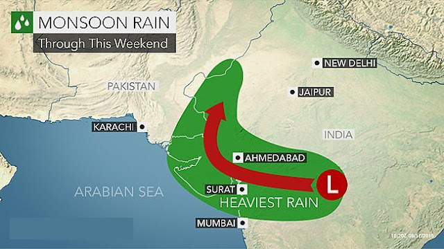
The Bay of Bengal depression that drenched Gujarat for 4 days will weaken and move to Jammu Kashmir and Himachal Pradesh by Wednesday through Rajasthan, Punjab and Delhi.

The depression/low lies over northern Saurashtra presently near Halvad (See Storm Tracker). Under its influence heavy showers are expected in Saurashtra till late evening today. The rains will move to northern Gujarat tomorrow and then into Rajasthan.

By Wednesday (September 23, 2015) the rains will quickly move through the state and then Haryana, Punjab, Delhi and Jammu Kashmir. Heavy rains are possible on Wednesday-Thursday in Jammu Kashmir and Himachal Pradesh.

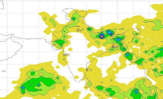
The following are the GFS rain forecast maps for September 21, 22, 23. The figures are in mm.


Rainfall Forecast till 1200 GMT, September 21, 2015

Rainfall Forecast till 1200 GMT, September 22, 2015

Rainfall Forecast till 1200 GMT, September 23, 2015

Share this PostPin ThisShare on TumblrShare on Google PlusEmail This

Weakened Depression Moves To Saurashtra Kutch: Heavy Rains Coming To Rajasthan, Haryana-Delhi, Jammu Kashmir

The European Model was right once again. The deep depression 99B that came from the Bay of Bengal has weakened to a low pressure and lies presently over central Gujarat.

Yesterday under its influence South, Central and parts of North Gujarat received good rainfall. In the night the rains moved to Saurashtra. Especially in Amreli and Rajkot districts.

The system will move over towards Kutch and hover over the Radhanpur-Deesa region of the state in the next 48 hours.

Under its influence many parts of Saurashtra, Kutch and parts of north Gujarat may receive heavy showers till Monday afternoon that is September 21, 2015.

The system will then leave Gujarat and move through Rajasthan, Haryana-Delhi and  to Jammu Kashmir.  It is possible that it may swing into northern Pakistan on Tuesday-Wednesday bringing heavy rains to Punjab province.

Very heavy rains are likely in Haryana-Punjab Jammu Kashmir by September 24, 2015 with chances of floods.
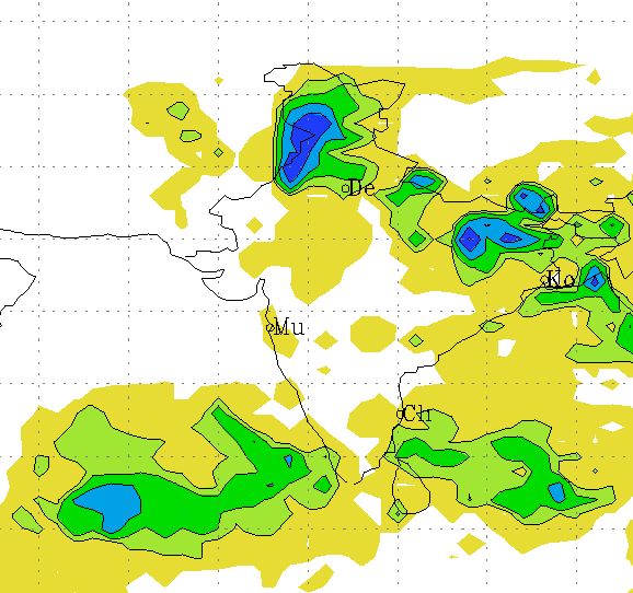
Flood causing rains likely  in Punjab, Jammu Kashmir by September 23, 2015
Rain forecast map for September 22,2015. Flood causing rains likely  in Punjab, Jammu Kashmir by September 23, 2015
Now, that is Saturday morning, the low is in dormant state. There is sunlight in many parts of Gujarat. But that is just an illusion. The system will strengthen by tomorrow and may bring heavy showers to Saurashtra Kutch and parts of North Gujarat. Especially in the districts of Amreli, Bhavnagar parts of Rajkot, Kutch, Kheda, Ahmedabad, Banaskantha and Patan.

There is a possibility of another low pressure area developing off the Karnataka coast around September 29, 2015 in the Arabian Sea.

See Detailed Rainfall Forecast Maps

Track The Storm


Satellite image of South Asia at 0500 hours GMT today. September 19, 2015

Share this PostPin ThisShare on TumblrShare on Google PlusEmail This

Heavy Rains Likely in Western And North India: Forecast Models Differ On Where In Gujarat

The depression that originated in the Bay of Bengal has reached Vidarbha in Maharashtra presently. As a result showers are occurring in western parts of the state.

One thing is sure. In the next 5 days the system will move through Gujarat, Rajasthan, Haryana, Punjab and reach Jammu and Kashmir. It is expected to weaken after leaving Gujarat on September 22, 2015 but the mentioned states will receive good rainfall.

Low pressure area rain track forecast gujarat rajasthan september 2015
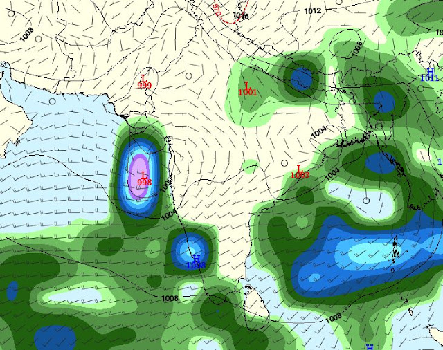
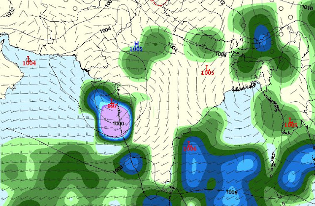
The GFS forecast on track and rain forecast of the low pressure area

The confusion lies in where it will rain in Gujarat under the influence of this system. Forecast models differ.

The GFS predicts the depression will weaken from the present 996 Mb system to 1002-4 system in a day or two. A mere low or an upper air cyclonic system. It says only south, central and parts of north Gujarat will get any significant precipitation. Saurashtra-Kutch will be left mainly dry.

The European ECMWF model foresees a stronger system. That the present depression will remain a 994 Mb system as long as it hovers above Gujarat. A stronger system means more rains. It also predicts that the low will move to Kutch and then onto Rajasthan. So this model predicts more rains in Saurashtra and Kutch.

See Detailed Rainfall Forecast Maps

Track The Storm

Satellite image of the low pressure area approaching western India. Image taken at 0530 hours GMT, September 18, 2015

Share this PostPin ThisShare on TumblrShare on Google PlusEmail This

Depression 99B To Bring Heavy Rains To MP, Maharashtra, Gujarat By September 20, 2015

The depression 99B that has formed in the Bay of Bengal and presently flooding Odisha has stamina. If forecasts are to be believed this system is not only to bring heavy rains to Chattisgarh, southern Madhya Pradesh, Vidarbha, northern Maharashtra, South and central Gujarat, and Saurashtra in the next 5 days but will in fact intensify from a 997 Mb storm to a 994 Mb storm when it hovers over Saurashtra on September 21, 2015.


It has just crossed the Odisha coast and bringing heavy precipitation to the region. In the next  72 hours it is going to reach Gujarat. On September 20, 2015 it will move onto Saurashtra and then hover over the region for a day or two and then abruptly move towards western Rajasthan and onto Haryana, Delhi and even Kashmir. Heavy rains are expected in these states till September 26.

The above was the American NCEP forecast. The European forecast differs on the track for the low pressure 99B. It predicts it will move into Sindh after Saurashtra and move north right through Pakistan. if the ECMWF model proves to be accurate then Pakistan is in for very heavy rains from September 22 onwards. And the system is expected to traverse throughout the country.

But that possibility seems to be receding. The latest data from the model says 99B will suddenly weaken on September 22, 2015 as it leaves Saurashtra and enters the Arabian Sea and then drift back through northwest Gujarat into Rajasthan and further into northern India before dissipating.

Wherever it goes 99B has a lot of energy and it will flood many areas before it peters out. And that is not expected for another 10 days.

Keep  in touch for latest forecasts for 99B. It has the computer models confused and they have been giving out different track forecasts with successive bulletins.

Big rain-maker system 99B needs to be closely monitored.

See Detailed Rainfall Forecast Maps

Track The Storm

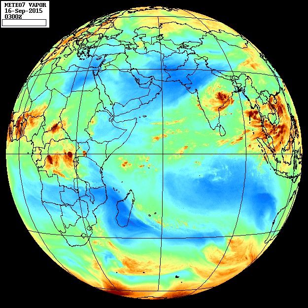
Depression/low 99B over Odisha. Latest satellite image 0400 GMT September 16 2015
Depression/low 99B over Odisha. Latest satellite image taken at 0400 GMT, September 16, 2015

Share this PostPin ThisShare on TumblrShare on Google PlusEmail This

Bay of Bengal Low Will Move To Arabian Sea September 18, 2015

Bay of Bengal low pressure area September 2015The Indian monsoon is withdrawing but storm activity has begun in the Bay of
Bengal with a low pressure area forming. This system is going to hover around near the Andhra coast for the next 5 days bringing rains to peninsular India especially in Odisha, Andhra, Telangana and northern Karnataka.

The low will then traverse west through India and hop into the Arabian Sea on September 18, 2015. Increased rainfall is expected in Konkan coast by then.

The low in the Arabian Sea may intensify into a depression and will move close by the coast of Saurashtra till September 24.

After that it will swing back into the open sea and move to northeastern coast of Oman. It will be gradually weakening all that time so Oman may expect some showers by September 27.

The European Model too supports increased storm activity near the Konkan coast around September 18-20, but it is not as hopeful as the GFS that the system will intensify much.

The European model envisages another Bay of Bengal low/depression moving through Odisha, Chattisgarh, Bihar and onto Uttar Pradesh around September 22, but the GFS stays mum on the forecast.

So we see different forecasts by two computer models.

The point they agree upon is... A Bay of Bengal low pressure moving west reaching Arabian Sea around September 19, 2015. The rest is differing predictions.

Monitor North Indian Ocean (Arabian Sea, Bay Of Bengal) LIVE
Share this PostPin ThisShare on TumblrShare on Google PlusEmail This

No Cyclone For Now In Arabian Sea

There is disappointing news for cyclone enthusiasts. Latest forecasts indicate that the possibility of a storm developing in the Arabian Sea is receding.

We had earlier portended that cyclone Chapala was imminent in the Arabian Sea on September 20, 2015. Latest data from the GFS model rules out this possibility.

The European Model denies even a low pressure in the Arabian Sea.

But a low pressure in the Bay of Bengal is very much in the cards. This low will be born within a couple of days. The ECMWF model is bearish on this system. It might throw down a lot of rain in Andhra and Telangana but then it expects it to fizzle out.

The GFS model is much more bullish. We stand by our earlier forecast of the Bay of Bengal low moving across Andhra, Telangana, Maharashtra and then rejuvenating in the Arabian Sea on September 20, 2015.

So lots of rain on Konkan coast and Mumbai around then. The low in the Arabian Sea will then move to coastal Saurashtra around September 22, but the chances of this low developing into a cyclone seems remote for now.

But what we say now may change in the coming days, so taking today's forecast as gospel truth would be a mistake. We are just reporting the trends. Anything can happen on September 20, 2015.

We notice another low developing in the Arabian Sea around September 25. A cyclone perhaps? But more on that as the situation develops.

Now some good news and some bad news.

The bad news is bad boy El Nino is still very strong even in September. It screwed up the Indian monsoon rains in 2015.

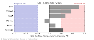
The good news is Indian Ocean Dipole (IOD) is strongly positive presently. A positive IOD means good rains and storms in North Indian Ocean.

El Nino strong September 2015
Bad news. El Nino is still strong in September
Indian Ocean Dipole positive September 2015
Good news! Indian Ocean Dipole very positive presently
Share this PostPin ThisShare on TumblrShare on Google PlusEmail This

Rain-Maker Depression To Deluge Andhra, Maharashtra, Mumbai By September 20, 2015

We had predicted a low pressure/depression in the Bay of Bengal and Arabian Sea almost a week ago. The system will form on September 14, 2015 near the Andhra coast.

The Bay of Bengal is already showing increased storm activity in preparation of the birth of the rain maker weather system.

The low pressure area will form off the eastern coast of India near Andhra Pradesh and hover around for the next two days till September 18 bringing heavy rainfall in Andhra Pradesh.

It will then cross the coast and move through Andhra, Telangana, Northern Karnataka, Maharashtra onto Mumbai.

Very heavy rains are expected in Mumbai on September 20.

The low pressure area will then intensify again in the warm waters of the Arabian Sea into a depression/deep depression (Forecasts rule out a tropical cyclone presently, but 10 days is a long long time in weather forecasting. Anything can happen).

The depression is expected to move along the Saurashtra coast into the open sea and reach the coast of central Oman on September 23, 2015. Though the European model believes it will move into Gujarat on September 20. We have to wait awhile before the picture becomes clearer.

In a nutshell the low pressure area is going to bring very heavy rains to Andhra to Mumbai from September 14.

 A SECOND DEPRESSION IN THE BAY OF BENGAL?

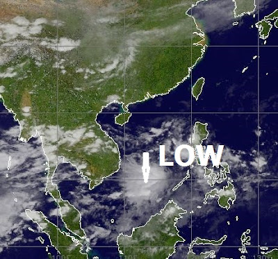
A forecast model predicts a depression moving into Odisha on September 21, 2015, but this is yet to be confirmed by other models. It appears that the present low pressure area in the South China Sea is going to do a lot of travelling over Vietnam, Thailand and Myanmar and then hop over into the Bay of Bengal on September 19. This will then gain strength and become a deep depression and hit Odisha as we have said earlier. Chances are this predicted system has the makings of another tropical cyclone. As there are  10 more days to go and forecasts have the habit of changing in these many days.

Bay of Bengal depression Odisha September 21, 2015
The European Model predicts this low in the South China Sea will hit Odisha on September 21, 2015


Cyclone CHAPALA to from off Konkan coast on September 20, 2015?

Monitor Bay of Bengal, Arabian Sea LIVE

Bay of Bengal Arabian Sea depression low pressure area September 2015
The depression as seen on September 21, 2015, moving away from the Indian coast off Mumbai.

Share this PostPin ThisShare on TumblrShare on Google PlusEmail This

Bay of Bengal, Arabian Sea To Come Alive With Storms In Coming Days

As a tepid monsoon begins withdrawing from South Asia the North Indian Ocean (Bay of Bengal and Arabian Sea) is going to change gears and throw out low pressure areas, depression and may be even a tropical cyclone in the coming days by September 20, 2015.

It will begin with the Bay of Bengal mothering two low pressure areas soon. The first one will be engendered around September 12, 2015. Opinions differ as to its fate. It may start off near the Myanmar coast then potter around and come near the Indian coast bringing good rains in Andhra, Odisha and Tamil Nadu and finally fizzle out in a week.

Or it may form off the Andhra coast and then intensify into a big rain-making deep depression on September 14 and move inland and move through Madhya Pradesh and reach even Gujarat.

The Bay of Bengal is expected to generate another low pressure area on September 19, 2015 which will move into northern and eastern states of India.

The Arabian Sea is the one which may throw out a tropical cyclone (Chapala) or a deep depression. It will start off as a low pressure area near the Goa coast on September 18 and then intensify into a tropical cyclone by September 20, 2015. Where it heads to remains to be seen. Gujarat, Pakistan or Oman?

We have wait for confirmation of this upcoming cyclone by the European model. The American GFS model has been gung-ho about it since last 4-5 forecasts.

TRACK THE NORTH INDIAN OCEAN LIVE

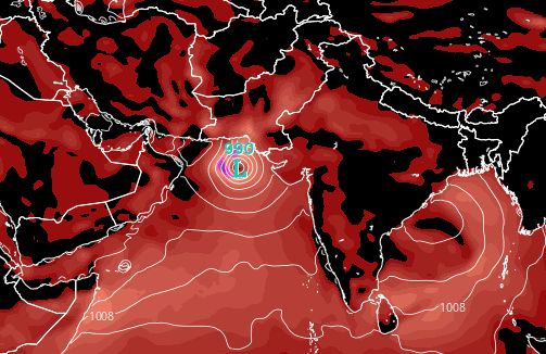
Arabian Sea cyclone deep depression September 23 2015
The situation as forecast by the GFS on September 23, 2015. The Arabian Sea cyclone/depression seems to be moving towards Oman.

Share this PostPin ThisShare on TumblrShare on Google PlusEmail This

Cyclone CHAPALA Imminent In Arabian Sea September 18, 2015

The weak monsoon of 2015 is rapidly withdrawing from India but the North Indian Ocean is likely to spawn a tropical cyclone in the coming fortnight. Cyclone Chapala may be born off the Mumbai coast in the Arabian Sea around September 20, 2015.

One notices that in a weak monsoon year the north Indian Ocean (Bay of Bengal and Arabian Sea) throws out more tropical cyclones.

This year we had Ashobaa and the deep depression in June that drenched Gujarat. The Bay of Bengal spawned a surprising cyclone Komen in the middle of the rainy season.

The birth of upcoming cyclone Chapala will occur in the Bay of Bengal. It will start off as a innocuous low pressure area on September 12, Saturday. The system will form off the Odisha coast but will bob around in the Sea and will intensify into a deep depression near the Andhra coast,

This storm will move through peninsular India and Mumbai on September 18, 2015 bringing heavy rains to the city. The depression will then move into the Arabian Sea and then intensify into a tropical cyclone Chapala. It will move past the coast of Saurashtra and head towards Oman. If latest forecasts are to be believed it will hit north-eastern Oman on September 22-23.

We prophesy all this on the basis of the predictions by the venerable GFS system. The ECMWF too agrees that a low pressure area will form in the Bay of Bengal by September 13.  It expects the system to strengthen into either a deep depression or a tropical cyclone on September 16 and hit the Indian coast of Andhra-Odisha. Whether it hops over peninsular India into the Arabian Sea and metamorphose into a cyclone is to be seen.

In a nutshell, the latest forecast situation. The GFS says a tropical cyclone in the Arabian Sea. The European model predicts a deep depression off Andhra coast.

Keep in touch for the latest predictions.

TRACK THE NORTH INDIAN OCEAN LIVE

Cyclone Chapala Arabian Sea September 2015 forecast
The GFS model predicts heavy rains in Mumbai and Konkan coast on September 19, 2015. It also foresees the birth of a cyclone after that in the Arabian Sea.

Share this PostPin ThisShare on TumblrShare on Google PlusEmail This

Latest Forecasts/Updates


Popular Posts

Search This Site