Showing posts with label Haryana. Show all posts

Rains Coming To Rajasthan, Punjab, Kashmir, Himachal Soon

The Bay of Bengal depression that drenched Gujarat for 4 days will weaken and move to Jammu Kashmir and Himachal Pradesh by Wednesday through Rajasthan, Punjab and Delhi.

The depression/low lies over northern Saurashtra presently near Halvad (See Storm Tracker). Under its influence heavy showers are expected in Saurashtra till late evening today. The rains will move to northern Gujarat tomorrow and then into Rajasthan.

By Wednesday (September 23, 2015) the rains will quickly move through the state and then Haryana, Punjab, Delhi and Jammu Kashmir. Heavy rains are possible on Wednesday-Thursday in Jammu Kashmir and Himachal Pradesh.

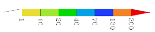
The following are the GFS rain forecast maps for September 21, 22, 23. The figures are in mm.


Rainfall Forecast till 1200 GMT, September 21, 2015

Rainfall Forecast till 1200 GMT, September 22, 2015

Rainfall Forecast till 1200 GMT, September 23, 2015

Share this PostPin ThisShare on TumblrShare on Google PlusEmail This

Heavy Rains Likely in Western And North India: Forecast Models Differ On Where In Gujarat

The depression that originated in the Bay of Bengal has reached Vidarbha in Maharashtra presently. As a result showers are occurring in western parts of the state.

One thing is sure. In the next 5 days the system will move through Gujarat, Rajasthan, Haryana, Punjab and reach Jammu and Kashmir. It is expected to weaken after leaving Gujarat on September 22, 2015 but the mentioned states will receive good rainfall.

Low pressure area rain track forecast gujarat rajasthan september 2015
The GFS forecast on track and rain forecast of the low pressure area

The confusion lies in where it will rain in Gujarat under the influence of this system. Forecast models differ.

The GFS predicts the depression will weaken from the present 996 Mb system to 1002-4 system in a day or two. A mere low or an upper air cyclonic system. It says only south, central and parts of north Gujarat will get any significant precipitation. Saurashtra-Kutch will be left mainly dry.

The European ECMWF model foresees a stronger system. That the present depression will remain a 994 Mb system as long as it hovers above Gujarat. A stronger system means more rains. It also predicts that the low will move to Kutch and then onto Rajasthan. So this model predicts more rains in Saurashtra and Kutch.

See Detailed Rainfall Forecast Maps

Track The Storm

Satellite image of the low pressure area approaching western India. Image taken at 0530 hours GMT, September 18, 2015

Share this PostPin ThisShare on TumblrShare on Google PlusEmail This

Latest Forecasts/Updates


Popular Posts

Search This Site