Showing posts with label Cyclone Mahasen. Show all posts

MAHASEN CYCLONE SEEMS TO BE WEAKENING FAST: MAY 16, 2013: HEAVY RAINS IN NE INDIA LIKELY (Final Track Path)

MAHASEN SATELLITE IMAGE: 1.30 PM (IST), 2.00 PM (BDT), MAY 16, 2013


Latest satellite images of MAHASEN show that the cyclone is weakening fast after it made contact with land. It seems likely that it will quickly move over into the Indian NE within 24 hours.

In other words Mahasen has fallen apart rapidly.

Also it seems the storm has bypassed Chittagong, moving by an area a few hundred kms north from Chittagong.

In the meantime, heavy rains. It rained heavily in Kolkata just a few hours ago. It is raining buckets in Bangladesh now.

And Bangladesh will get some very very strong winds (It is getting it now).

It is raining heavily in the NE states. This will increase as the remnants of Mahasen moves over it. So rains in the Indian NE states for another day or two.

Cyclone often weaken quickly after landfall. That seems to be happening with Mahasen.

I will not be surprised if the sun shines on some parts of Bangladesh tomorrow.

Final Track/Path Of Mahasen
Share this PostPin ThisShare on TumblrShare on Google PlusEmail This

MAHASEN CROSSES INTO BANGLADESH MAY 16, 2013

SATELLITE IMAGE OF MAHASEN. TODAY MAY 16, 2013. 1.00 PM (IST)

Mahasen cyclone is before time. It has already touched the Bangladesh coast at Patuakhali district and will hit Chittagong soon.

Patuakhali recorded winds of about 100 kph.

Very strong winds are expected in Bangladesh for another 12 hours.

It is already raining heavily now in Bangladesh. 

Assam and other NE states is receiving heavy rains now. They will continue for another 24 hours.


Share this PostPin ThisShare on TumblrShare on Google PlusEmail This

MAHASEN NEARS CHITTAGONG! HEAVY RAINS LASH BANGLADESH!

INFRA-RED IMAGE OF MAHASEN TODAY (12.00 NOON, IST) MAY 16, 2013


"MAHASEN" NEARS CHITTAGONG! WILL HIT TODAY EVENING. IT IS RAINING VERY HEAVILY IN KOLKATA AND WEST BENGAL.

CYCLONE 'MAHASEN' LATEST FORECAST UPDATE: MAY 16, WEDNESDAY, 12.45 PM (BDT), 12.15 PM (IST)

Mahasen is currently about 200 kms SE of Chittagong.

Under its influence, large parts of Bangladesh are reeling under heavy rains. Heavy rains have started in Dhaka. The current winds will increase as Mahasen cross the coast. Strong winds are likely for at least another 12 hours.

When its hits the Bangladesh coast late afternoon May 16, 2013 wind speeds of about 85 kph will lash CHITTAGONG and neigboring areas.

When MAHASEN slams into the Bangladesh coast today it will be accompanied with very heavy rains, strong winds (>85 kph) and waves of 12 feet.

Areas withing a 200 km radius of Chittagong will feel the strongest winds. Cox's Bazar will get a severe lashing.

Very heavy rainfall is expected in Bangladesh today and tomorrow. Heavy rains are already lashing the country and parts of West Bengal.

Assam and other NE states will receive heavy rains on May 16-18. Mizoram and Manipar will get strong winds and heavy rains starting today night.

Eastern and southern Bangladesh, and northern Myanmar (including Yangon) will feel the effects of the storm.

Share this PostPin ThisShare on TumblrShare on Google PlusEmail This

Latest Satellite Image Mahasen> Today May 16, 2013, 6.00 AM (BDT)

SATELLITE IMAGE OF MAHASEN TAKEN TODAY, MAY 16, 2013, 6.00 AM (BDT)

Share this PostPin ThisShare on TumblrShare on Google PlusEmail This

XTREME WEATHER FORECAST FOR LAYMEN: CYCLONE MAHASEN COMING EARLIER! TO HIT BANGLADESH COAST TOMORROW (MAY 16, 2013) AFTERNOON!

XTREME WEATHER FORECAST FOR LAYMEN: CYCLONE MAHASEN COMING EARLIER! 
TO HIT BANGLADESH COAST TOMORROW (MAY 16, 2013) AFTERNOON!
People of Chittagong await "Mahasen" on Thursday


CYCLONE REACHING BANGLADESH TOMORROW (MAY 16, 2013) AFTERNOON.

CYCLONE 'MAHASEN' LATEST FORECAST UPDATE: MAY 15, WEDNESDAY, 9.30 PM (BDT), 9.00 PM (IST)

Mahasen hovers in the Bay of Bengal. The nature's juggernaut moves inexorably towards its final destination. Ground zero is Chittagong

It has started intensifying and will reach speeds up to 95 kph (or more). It will hit the Bangladesh coast late afternoon May 16, 2013. That is Thursday afternoon.

When MAHASEN slams into the Bangladesh coast tomorrow it will be accompanied with very heavy rains, strong winds (>85 kph) and waves of 12 feet.

Very heavy rainfall is expected in Bangladesh on May 16, 2013 beginning today night as the storm comes near.

Assam and other NE states will receive heavy rains on May 16-18.

Eastern and southern Bangladesh, and northern Myanmar (including Yangon) will feel the effects of the storm.
Share this PostPin ThisShare on TumblrShare on Google PlusEmail This

CYCLONE MAHASEN COMING EARLIER! TO HIT BANGLADESH COAST TOMORROW (MAY 16, 2013) AFTERNOON!


Mahasen seems to have revved up. It is likely to hit Bangladesh coast, near Chittagong not May 16 night but tomorrow afternoon (almost evening). Latest satellite images show that the edges of the storm are almost touching the Bangladesh coast.

The wind speeds on the Bangladesh coast tomorrow afternoon will be  about 90+ kph. Very heavy rains which will start tonight, will lash the country tomorrow. It will throw up waves of almost 12 feet.

Mahasen will not only deluge Bangladesh but will bring heavy rainfall to Indian NE states from May 16, 2013, onwards.
Share this PostPin ThisShare on TumblrShare on Google PlusEmail This

MAHASEN LATEST UPDATE: Will Hit Chittagong Thursday Night: 90+ Kph Winds

Projected path of Mahasen. May 15, 2013


Latest forecast (MAY 15, 2013, 11.00 AM BDT) say that MAHASEN will be slightly less powerful than feared earlier. But it will still pack a big punch. It will touch top wind speeds of 110 kph. It is likely to slam into Chittagong on the night of May 16, 2013. That is Thursday night. Winds of more than 90 kph will hit the city. Waves of 12 feet will be thrown up. And very very heavy rainfall in entire Bangladesh on May 17, 2013.

People of Bangladesh, especially of Chittagong are advised to make adequate preparations.

We will keep you informed of the latest.

INFRA-RED SATELLITE IMAGE OF MAHASEN TAKEN TODAY AFTERNOON

Share this PostPin ThisShare on TumblrShare on Google PlusEmail This

LATEST CYCLONE "MAHASEN" UPDATE, MAY 14, 2013: Now Moving Towards Bangla Coast, Will Hit On May 17

RAIN PREDICTION MAP: VERY HEAVY RAINS EXPECTED IN BANGLADESH ON MAY 17, 2013.


In the last few hours Mahasen was changing course. Now it is slowly curving a path to Bangladesh. And it is expected to grow in intensity. In the next two days it will touch wind speed of about 130 kph.

It is expected to touch the Bangladesh coast on May 17, 2013. Very strong gale will lash the coastal areas with speeds up to 120 kph. It will be accompanied with heavy rains. Intermittent rains have already started in the country which will increase as the storm comes closer.

We are basing our predictions mainly on what the JTWC (Joint Typhoon Warning Center) says. Please note that the IMD differs in its forecast. IMD says wind speeds will be much lesser. But now even IMD says that the wind speed will be 90+ kph.

We will keep you updated.

Share this PostPin ThisShare on TumblrShare on Google PlusEmail This

LATEST MAHASEN FORECAST UPDATE, MAY 13, 2013: To Intensify Next 2 Days To 130 Kmph, Hit Chittagong On May 17

Satellite image of "Mahasen" taken today at 12.30 PM (IST)

Now is the time that Mahasen will start curving NNE towards Bangladesh. And it is going to intensify further in the next two days into a big big storm. Contrary to what the IMD says,  Mahasen is going to be a very big storm. Its wind speeds will touch a mind boggling 130 kph on the 15th of May. Even when it hits Chittagong on the morning of May 17, it will throw a gale of a 100 kph.

The Bangladesh authorities have wisely started all precautions on a war footing.

It will be the strongest when it will be 400 kms south of Kolkata on May 15.

Mahasen is giving lots of rain on the Indian coast. It has been raining heavily in Andhra Pradesh since yesterday. Today the Tamil Nadu coast got a deluge.

Gangetic West Bengal and Bangladesh will receive very heavy rains from May 16.


XtremeWeather Forecast Map: Forecasted Psth of "MAHASEN"

xxx


Share this PostPin ThisShare on TumblrShare on Google PlusEmail This

Latest JTWC FORECAST (May 12, 2.30 PM IST) For MAHASEN Says It Will Be A Much Bigger Storm


MAHASEN WILL HIT BANGLADESH COAST NEAR CHITTAGONG ON MAY 16, 2013. VERY HEAVY WINDS WILL LASH THE BANGLADESH COAST.

We had said earlier that there is a difference in how the IMD and the JTWC predict the future of Mahasen cyclone. The latest JTWC bulletin (issued today at 2.30 PM, IST) says Mahsen will be bigger storm than what IMD (and most media) says. IMD says the maximum wind speeds Mahasen will throw up will be 55-65 kmph. JTWC says the maximum speeds will be an astounding 150 kmph.

Below is a gist of what the latest JTWC forecast says....


TC 01B (MAHASEN) IS FORECAST TO CONTINUE NORTHWESTWARD FOR THE NEXT 12 HOURS..... IT IS EXPECTED TO SLOW DOWN BEFORE IT TURNS NORTHEASTWARD..... THE SYSTEM WILL MAKE LANDFALL NEAR CHITTAGONG, BANGLADESH, AS A SIGNIFICANT CYCLONE.

JTWC PREDICTED WIND SPEEDS AND POSITION OF MAHASEN: (1 Knot= 1.852 Kmph)

PRESENTMAX SUSTAINED WINDS - 045 KNOTS, GUSTS 055 KNOTS

 MAY 12 1800 HRS UTC --- 10.8N 86.6E
   MAX SUSTAINED WINDS - 055 KNOTS, GUSTS 070 KNOTS

MAY 13, 0600 UTC --- 11.8N 86.3E
   MAX SUSTAINED WINDS - 060 KNOTS, GUSTS 075 KNOTS

MAY 13, 1800 UTC --- 13.0N 86.3E
   MAX SUSTAINED WINDS - 065 KNOTS, GUSTS 080 KNOTS

MAY 14, 0600 UTC --- 14.3N 86.8E
   MAX SUSTAINED WINDS - 070 KNOTS, GUSTS 085 KNOTS

MAY 15, 0600UTC --- 17.0N 88.4E
   MAX SUSTAINED WINDS - 080 KNOTS, GUSTS 100 KNOTS

 MAY 16, 0600UTC --- 20.4N 91.0E
   MAX SUSTAINED WINDS - 070 KNOTS, GUSTS 085 KNOTS

MAY 17, 0600 UTC --- 23.7N 94.0E
   MAX SUSTAINED WINDS - 040 KNOTS, GUSTS 050 KNOTS


Latest May 12, 2013, 3.30 PM) Forecasted Path of MAHASEN

Share this PostPin ThisShare on TumblrShare on Google PlusEmail This

CYCLONE "MAHASEN" LATEST UPDATE: 1.00 PM, MAY 12, 2013:INDIAN MET SAYS WEAKER, JTWC SAYS BIGGER

Rainfall Prediction Map: Mahasen Cyclone
There seems to slight difference in opinion between the two main expert forecasters for cyclone MAHASEN.


The Indian Met Department (IMD) says Mahasen has weakened and will remain a weak storm (65-75 Kmph) till it makes landfall on the Bangladesh-Myanmar border. IMD says Mahasen will slip between cyclone strength when it makes landfall on early morning May 17, 2013 (IST).

JTWC (Joint Typhoon Warning Center) says Mahasen will be a much stronger storm. Touching 155 kmph on May 16, 2013. JTWC says ground zero will be Chittagong, May 17 early morning.

We will keep giving you the latest updates.


Share this PostPin ThisShare on TumblrShare on Google PlusEmail This

LATEST UPDATE BAY OF BENGAL MAHASEN CYCLONE: 01B (8.00 AM IST, MAY 11, 2013):Target Chittagong, Bangladesh On May 15, 2013

The Indian Met Dept has finally christened the cyclone in the Bay of Bengal as Mahasen .Click here to read its prediction
Latest Predicted Path of Tropical Cyclone 1B (Mahasen?) May 11, 2013


Latest forecasts for tropical cyclone 1B in the Bay of Bengal says that its target is going to be Chittagong, Bangladesh. Mahasen is likely to hit the Bangladesh coast on late evening of May 15, 2013. Maximum speeds are likely to be 85 knots (155 knph) which is nothing to sneeze at.

We will keep you posted.


Share this PostPin ThisShare on TumblrShare on Google PlusEmail This

"MAHASEN" CYCLONE UPDATE MAY 10, 2013 (11.40 AM UTC): Big Big Storm In The Making Heading To Myanmar Finally: ALSO PROJECTED PATH MAP

ExtremeWeather Prediction Map: Projected path of Cyclone "Mahasen" according to JTWC.
CLICK HERE TO SEE LARGER IMAGE

Latest forecast by the JTWC (Joint Typhoon Warning Center)  says the long awaited tropical storm (We predicted it ten days before on May 1, 2013) in the Bay of Bengal has finally been spawned. JTWC has named it 01B. The low pressure area has grown up to a big storm.

Mahasen (when, IMD?) has grown into manhood .

JTWC says Mahasen is gonna  grow to a big storm with winds of knots (167 kmph). Maximum winds will be 110 knots (200 kmph). This is going to be on May 14, 2013 when Mahasen will be at its strongest. It is going to throw up waves of 10 feet in the sea. Nasty man this Mahasen is going to be.

Mahasen is likely to make landfall into Myanmar on May 15, 2013.

*****************************************************************************
The Indian Met Department issued this bulletin today at 07.15 PM (IST)
Latest satellite imagery and observations indicate that a depression has formed over southeast Bay of Bengal and lay centred at 1430 hrs IST of today, the 10th May 2013 near latitude 05.00N and longitude 92.00E, about 450 km south-southwest of Car Nicobar, 1250 km east-southeast of Trincomalee , 1550 km southeast of Chennai and 1900 km south of Chittagong. The system would intensify into a deep depression during next 24 hrs and subsequently into a cyclonic storm. It would move initially northwestwards during next 48 hrs. and recurve thereafter northeastwards towards Bangladesh-Myanmar coast.


Share this PostPin ThisShare on TumblrShare on Google PlusEmail This

BAY OF BENGAL TROPICAL CYCLONE 01B UPDATE MAY 10, 2013 (10.50 UTC): JTWC CHRISTENED IT 01B


The storm has formed. JTWC has given it the name 01B. Will IMD name it as Mahasen?

The predicted path remains as we said before. Target Myanmar on May 13, 2013.

We will keep you posted.
Share this PostPin ThisShare on TumblrShare on Google PlusEmail This

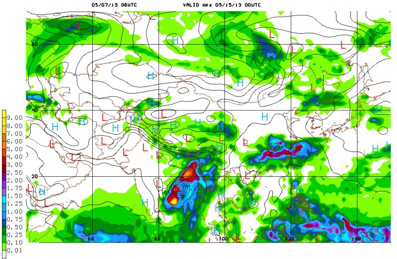
CYCLONE MAHASEN FORECAST UPDATE MAY 7, 2013: Bangladesh On May 15

XtremeWeather Weather Forecast Map: May 15, 2013: MAHASEN about to strike the WB-Bangladesh coast. The yellow color is very heavy rainfall.
We had said once that Mother Nature is difficult to fathom. How true!

Latest forecast for forthcoming tropical storm "Mahasen" says it is going to be Bangladesh on May 15, 2013. (Aside: One wonders if it will be Myanmar next!).

The birth of MAHASEN will take place tomorrow in the Bay of Bengal as predicted before as a low pressure area. From May 11th, 2013, it will grow up into a tropical cyclone and move NNW for the next few days and make landfall on the West Bengal-Bangladesh coast on May 15, 2013.

Under its influence Orissa, West Bengal and Bangladesh will face strong winds and torrential rains from May 14th, 2013.

Keep reading this site for the twists and turn in the saga of big bad MAHASEN.

-----------------------------------

The IMD had this to say today.....

An upper air cyclonic circulation over central parts of south Bay of Bengal extending upto mid ­tropospheric levels persists. Under its influence, a low pressure area may develop over south Bay of Bengal during next 48 hours.
Share this PostPin ThisShare on TumblrShare on Google PlusEmail This

MAHASEN UPDATE: MAY 7, 2013: Low Pressure Area To Form Tomorrow

Mahasen about to hit Andhra-Orissa coast on May 14th, 2013. The purple color means very strong winds.
Mahasen will take birth as a low pressure on May 8, 2013 ESE of the Sri Lankan coast. It will then just toddle around more or less stationary for the next three days. On May 11, 2013 the low pressure area will start gaining strength and turn into a cyclone. It will be christened "Mahasen" then. On May 11, 2013.

It will move  in a NNW direction  and and then northwards move  towards Visakhapatnam. Tamil Nadu escapes from its fury altogether according to latest forecasts. It will slam into the Andhra-Orissa border at Gopal-At-Sea on  May 14, 2013 and then lose power. Coastal Orissa (Gopal-on-sea) will bear the brunt of the fury.

Mahasen will have maximum winds of about 100 Kmph. Pretty powerful stuff that.

The rains?  Tamil Nadu will get some rains. Andhra, Orissa, West Bengal, Bangladesh, and NE states will get most of the deluge from May 13, 2013.. Heavy rains in these areas till the 20th of May, 2013. Floods would be better word.

Winds? Strong gales on the Andhra Pradesh and Orissa coasts from May 14, 2013.

XtremeWeather Map: Latest Projected Path Of Cyclone Mahasen: May 10 to May 14, 2013


-----------------------------------------------

The Metoffice, UK's weather department, has given this forecast for Mahasen....


GLOBAL MODEL DATA TIME 12UTC 06.05.2013


NEW TROPICAL STORM FORECAST TO DEVELOP AFTER  36 HOURS


FORECAST POSITION AT T+ 36 :  6.3N  82.5E

  VERIFYING TIME     POSITION     STRENGTH        TENDENCY

  --------------     --------     --------        --------

 00UTC 08.05.2013   6.3N  82.5E     WEAK       LITTLE CHANGE

 12UTC 08.05.2013   6.7N  81.6E     WEAK       LITTLE CHANGE

 00UTC 09.05.2013   7.4N  81.3E     WEAK       LITTLE CHANGE

 12UTC 09.05.2013   6.9N  81.6E     WEAK       LITTLE CHANGE

 00UTC 10.05.2013   7.4N  81.2E     WEAK       LITTLE CHANGE

 12UTC 10.05.2013   7.0N  81.6E     WEAK       LITTLE CHANGE

 00UTC 11.05.2013   7.9N  81.7E     WEAK    INTENSIFYING SLIGHTLY

 12UTC 11.05.2013  10.3N  85.5E   MODERATE     LITTLE CHANGE

 00UTC 12.05.2013  11.6N  84.9E   MODERATE  INTENSIFYING SLIGHTLY

 12UTC 12.05.2013  13.2N  84.9E    STRONG   INTENSIFYING SLIGHTLY


-------------------------------------------------

XtremeWeather Rain Forecast Map Because Of Mahasen

Share this PostPin ThisShare on TumblrShare on Google PlusEmail This

MAY 6, 2013: CYCLONE MAHASEN FORECAST UPDATE: To Make Landfall Near Visakhapatnam May 12, 2013

The forecast for the hour remains basically the same. Mahasen will form as a low pressure area east of the Sri Lankan coast on May 8, 2013. It will then move in a north westerly direction towards Chennai then swing northwards touching the Andhra coast near Vizag on May 12, 2013.

After that it will start weakening below cyclone strength and move along the coast bringing heavy rains to coastal Andhra, Orissa, West Bengal, Bangladesh and Indian NE states for the next four days.

Very heavy rains are likely in the areas mentioned. Call it a deluge if you like.

Mahasen is going to be a big storm.

XtremeWeather Forecast Map: Predicted path of Cyclone MAHASEN, May 8, 2013 to May  13, 2013.
---------------------------------------------------------------
One of our readers, Rao,  has written in a very valuable technical piece of forecast for MAHASEN. We quote part of his contribution.

Mahasen’ super cyclone forecast for Andhra Pradesh:2013, may 8-15 Andhra Pradesh super cyclonic storm ‘Mahasen’: (a) SOI will be within ±5 limit (b) Madden Julian oscillation index will be in enhanced 2 or 3 phase (c) nino3 will have negative value
Note 1: 2010, may 17-20 ‘Laila’ has not become super cyclone due to MJO index is in suppressed 4 phase. However ‘Mahasen’ will attain super cyclonic strength due to favorable energetic 2 or 3 phase enhanced MJO index before crossing Andhra Pradesh coast.

-------------------------------------------------------------------
The Indian Met. Dept. has this to say today....(May 6, 2013)

♦  A low pressure area may develop  over southwest Bay of Bengal during next 48 hours 
Share this PostPin ThisShare on TumblrShare on Google PlusEmail This

As We Predict Mahasen, Official Weatherman Remains Non-committal

While we have been giving the latest forecast updates about the impending tropical storm "Mahasen" since the last five days, the official weatherman (read IMD) remains cautious and non-committal.

Here is what he says....(From Hindu, May 5, 2013)

However, officials of the meteorological department said there was no possibility of a low pressure development over the next few days. 
S.R. Ramanan, director of Area Cyclone Warning Centre, said that sometimes, such systems did not develop into low-pressure areas. There is, however, some cloud cover about 250 km west of Chennai, he said. “We are studying the weather models to see if it will bring rain to the city,” he said


Share this PostPin ThisShare on TumblrShare on Google PlusEmail This

MAY 5, 2013: CYCLONE MAHASEN FORECAST UPDATE: Ground Zero: Visakhapatnam, Andhra May 13, 2013

Xtreme Weather Prediction Map: Tropical storm "Mahasen" on May 12, 2013
Cyclone Mahasen which is expected to be formed in the southern Bay of Bengal on May 8, 2013 is likely to make landfall at Visakhapatnam, Andhra Pradesh on May 13, 2013. After touching the Andhra coast Mahasen will skim over the Orissa, West Bengal coast weakening all the time.

Very heavy rains are expected at coastal Andhra, Orissa, West Bengal and Bangladesh from May 12 to May 16, 2013 because of Mahasen

Mahasen after forming east of the Sri Lankan coast on May 8 or May 9 will then move in a NWN direction and touch Andhra on May 13. It will grow in strength all time.

Another forecast model says that Mahasen will make landfall at Chennai on May 11, 2013. It also says that it will not be as powerful a storm as predicted by the former model.

All models agree that the Indian east coast, Bangladesh and Indian NE states are in for very heavy precipitation till May 16, 2013.

Talking of the Arabian Sea, forecast models say there is going to be a heavy build-up of clouds in southern Arabian Sea around the 20th of May. Experience tells us that such cloud build-up in the seas usually spawns a storm. A cyclone in the Arabian Sea in the end of May? Who knows?
Share this PostPin ThisShare on TumblrShare on Google PlusEmail This

MAY 4, 2013 TROPICAL MAHASEN FORECAST UPDATE : Big Cyclone To Hit Tamil Coast May 11, 2013


Mother Nature seems to have made up its mind. It is going to vent its fury in the form of tropical cyclone Mahasen. And Tamil Nadu is going to bear the brunt of the fury.

Todays forecasts say Mahasen is gonna be a big big bad boy. May be a super cyclone.

Birth date? May 8, 2013. Landfall? Tamil Nadu coast south of Puducherry on the 11th of May, 2013.

Predicted path of Cyclone Mahasen: May 8 to May 11, 2013
Share this PostPin ThisShare on TumblrShare on Google PlusEmail This

Latest Forecasts/Updates


Popular Posts

Search This Site