Showing posts with label monsoon 2015 forecast. Show all posts

Monsoon 2015 Active in North, Eastern India Till August 20

The Indian monsoons will remain active in central, northern and eastern India till August 20, 2015. Western and northwest India will remain mainly dry.


This has been a mainly disappointing rainy season for the states of Gujarat and Rajasthan. Barring the flooding periods in June (the Arabian Sea depression) and July these states have seen long dry periods.

The present forecasts by leading computer models predict the monsoon will keep drenching the states of West Bengal, North Eastern States, Bihar, Madhya Pradesh, Odisha and parts of Uttar Pradesh. In other the usual suspects. There might be localised heavy downpours but there are no huge area drenching lows or depression in sight in the near future.

A low pressure area is likely to form in a day or two near the Odisha coast but it is going to be a weak fellow. Not strong enough to reach western or northwestern India.

But computer models might go wrong. Why do we say that?

We have discerned a trend that the Pacific Ocean and the Indian Ocean take turns in becoming active. When one is throwing out a typhoon or a big rainmaker system the other one goes relatively inactive.

Presently it is the turn of the Pacific Ocean. The big monster Soudelor has smashed Taiwan and is hitting China which cowers in expectations of flood in north eastern part of the country. The other guy in the Pacific, Molave, is turning out to be a sissy. A small tropical storm which will swirl away northeast away from Japan.

So in a few days time, it will be the turn of the Indian Ocean to become vigourous again. That means monsoons getting strong again in South Asia. This may happen around August 20, 2015.

We hope it happens. The dire forecasts of a drought by the IMD has left us depressed and shaken.

EPILOGUE

Our hearts go out to the folks in Oman and UAE. The temperature is touching 46 degrees centigrade! We have experienced this kind of heat and we know how it feels. One prays for a post monsoon cyclone in the Arabian Sea this year.

UPDATE AUGUST 9, 2015

Predictions have changed. Bad news for Indian monsoon. The Pacific Ocean is not going to stay satisfied with typhoons Soudelor and Molave. Within a week two more typhoons (Goni and Atsani) are going to be spawned in the area. One of them is most probably going to hit Philippines.

Anyway. Goni and Atsani means the Pacific Ocean is going to remain in overdrive and the Indian Ocean will remain in a dormant stage. So a weak monsoon spell will continue till the end of August 2015.

Satellite image south asia august 8 2015 monsoon forecast
AUGUST 8, 2015 1000 HOURS GMT SATELLITE IMAGE SOUTH ASIA

Share this PostPin ThisShare on TumblrShare on Google PlusEmail This

Monsoon Rains In Eastern, Central India Till July 20, 2015

Monsoons will remain active over eastern, northeastern and parts of northern India in the next 15 days.


The present spells of rainfall in the states of West Bengal, Bihar, parts of Uttar Pradesh, the entire Indian northeast and Bangladesh is expected to continue in the coming 15 days. The region has a string of low pressure areas hovering above which will continuously feed rain to the above mentioned states.

The wet spell may occasionally stretch to western Uttar Pradesh, Delhi, Haryana and Punjab but most of the precipitation will be concentrated in eastern India. Not to forget the areas on the foothills of the Himalayas. Namely Sikkim, Nepal, Uttaranchal and Himachal.

monsoon update july 6 2015 india satellite image
This rainfall satellite image was taken at 0500 GMT, July 6, 2015

A low pressure will form near the Odisha coast on Friday, July 10, 2015. This system will be a big rain maker and move through Chattisgarh and onto Madhya Pradesh after that. But it will start weakening and is not likely to reach western India.

The dire predictions of the Indian Meteorological Department seems to be coming true. The monsoon appears weak. In July usually the Bay of Bengal hurls lows and depressions one after another that cut across central and western India and bring rains to Gujarat, Rajasthan and Haryana-Punjab.

This year not one such system has formed. Gujarat was lucky to have that Arabian Sea depression in late June. Rajasthan still thirsts for rains.

The Bay of Bengal low that will form on July 10, 2015 will be a weak one. Weak low pressures equals weak rainy season this year.

The Western Pacific Ocean is presently spewing a string of powerful typhoons, one after another. Typhoons Chan-Hom, Linfa, Nangka, And there are a couple of  Invests in the waiting list. Phew! Its sucking off steam from the monsoons.
Share this PostPin ThisShare on TumblrShare on Google PlusEmail This

Monsoon Forecast: Heavy Rains Expected In Bengal, Bihar Till June 27, 2015

The low pressure area which is presently over Bangladesh will move through West Bengal and Bihar by June 27, 2015 bringing heavy rains to these states.


Very heavy rainfall is expected in Bangladesh today. The rains will shift to north Bengal and then onto Bihar by tomorrow.

Very heavy rains are expected in sub Himalayan West Bengal and Bihar in the next 48 hours.

One fears of flooding in Bihar by Sunday.

The rains will ease by Monday as the low will dissipate by then.. There may be rainfall in eastern Uttar Pradesh too in the next 48 hours.

monsoon rainfall bihar west bengal june 2015
The latest (0430 hours GMT, June 26, 2015) rainfall satellite image shows rains in North Bengal presently.


Share this PostPin ThisShare on TumblrShare on Google PlusEmail This

After Gujarat, Monsoon Will Shift To Uttar Pradesh. Heavy Rains By June 27, 2015

The next deluge spot in India after Gujarat is Uttar Pradesh. The reason being the Bay of Bengal low will collide with the remnants of the Arabian Sea low in the next 3 days. The result will be flooding.


The Bay of Bengal low is now in Banglasdesh. In the next two days it will move through West Bengal onto Bihar. The Arabian Sea rain system, which flooded Saurashtra is presently in northern Madhya Pradesh. In the next two days it will move towards eastern Uttar Pradesh. On June 27, June 2015, the two system will collide over the Uttar Pradesh-Bihar border.

The result will be heavy rains in the region.

So by the 27th of June we can envisage good rainfall activity in the following areas. Northern Madhya pradesh and Uttar Pradesh due to the Arabian Sea system. Bangladesh, West Bengal, Bihar and eastern Uttar Pradesh owing to the Bay of Bengal low pressure system.

The next big activity in monsoon 2015 will be a low pressure area forming in the Bay of Bengal around July 5, 2015. This is expected to move through Andhra, Chattisgarh and Madhya Pradesh. But this will be a weak system.

The reason? The expected massive typhoon that will form in early July, 2015 in the Western pacific and which will hit Hongkong, Macau and northern Vietnam.

There is a deep relationship between the storm activity in the north Indian Ocean and West Pacific. Especially with the strong prevailing El Nino the storm activity is rationed between the two oceans. One gets active then the other gets passive.

Since two typhoons are expected in early July in the Western Pacific, one can assume that there is going to be big lull in the Indian monsoons in the first half of July 2015.

bay of bengal low monsoon 2015 bangladesh
The Bay of Bengal low is presently about to enter Bangladesh.

Share this PostPin ThisShare on TumblrShare on Google PlusEmail This

DEPRESSION WILL INTENSIFY RAPIDLY, HIT SAURASHTRA TONIGHT

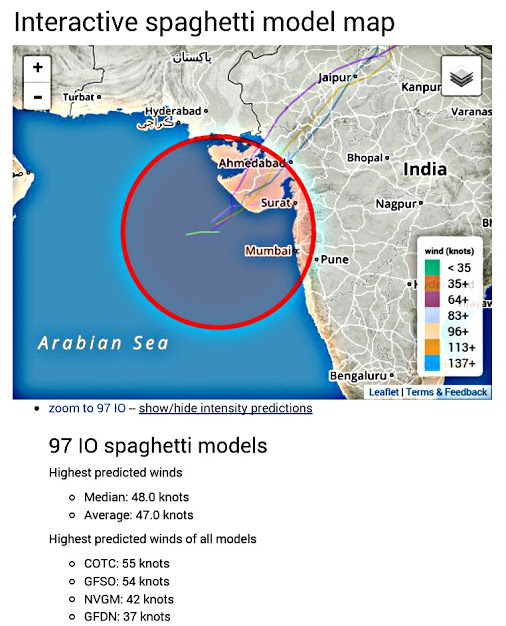
The latest GFS forecast data that is coming in says Arabian Sea deep depression 97A may rapidly intensify in the coming 12 hours, perhaps into a tropical cyclone and hit the Saurashtra Coast at Veraval today midnight. That is 0000 hours IST, June 23, 2015, Tuesday.


It is possible that wind speeds at impact will be 70-80 km/h, gusts upto 90 km/h.

The gale will be accompanied by torrential rains.

The deep depression/cyclone will swing North after making landfall and move into Kutch.

The most affected districts will be Gir Somnath, Porbandar, Junagadh, Rajkot, Morbi, and Kutch.

One wonders if the authorities are taking this possible threat seriously. The worry is if the GFS forecast turns true, there are just 14 hours before impact.

We are constantly monitoring what various computer forecasts models are saying and also the latest IMD (Indian Meteorological Department) updates.

Please keep in touch for breaking forecasts.

arabian sea depression 97A cyclone forecast
Arabian Sea Storm Intensity Forecast from Cyclocane. Only one model says it will not turn into a tropical storm.

arabian sea depression cyclone 97A forecast
Cyclone tracking site cyclocane.com says Arabian Sea depression 97A will be a tropical cyclone

Share this PostPin ThisShare on TumblrShare on Google PlusEmail This

Latest Forecasts/Updates


Popular Posts

Search This Site