Hurricane PATRICIA will reach Baffin Bay on November 2!

This lady monster has stamina! Hurricane Patricia is a category 5 tropical cyclone in north east Pacific Ocean and has given Mexico a fright of its life. It is going to hit Jalisco province of the country at around 0000 GMT, October 24, 2015. That is in less than 18 hours.

The hurricane will rapidly weaken into a tropical storm hours after impact and then into a tropical depression after that. But it is going to bring very heavy rains as it cuts across Mexico.

By October 25 it will have reached Houston, Texas. Patricia will go for a brief stroll in the Gulf of Mexico. On October 28 it will re-enter the United States and move through Mississippi, Alabama and Kentucky.

In the next 48 hours after that Patricia will move through the states on the eastern coast (including New York) and through Quebec, Newfoundland in Canada into Labrador Sea.

By November 2 the system will have turned into a extra-tropical cyclone and entered Baffin Bay. 

So we see that Patricia is no ordinary hurricane. It is going to travel through 3 countries in the coming 10 days.

We have based our predictions on the forecast data from the ECMWF model. It had been proved right from the beginning during hurricane Joaquín. It had predicted it would not make landfall into eastern USA even as other models, including the NHC were predicting a hit on the eastern coast.

Latest satellite image of category 5 hurricane Patricia 

Share this PostPin ThisShare on TumblrShare on Google PlusEmail This

Cyclones CHAPALA MEGH Imminent In Arabian Sea, Bay of Bengal Soon?

By XWF, October 22, 2015

Global forecast models are hinting at the possibility of the North Indian Ocean spawning 2 tropical storms in the coming days this October-November 2015.

It is not certain at this stage whether the expected systems will be depressions or tropical cyclones.

The Arabian Sea storm will arise first around October 26-27. Opinions differ as to what track path it will take. One scenario is it will hit northern Yemen around November 2. Another scenario is it makes landfall into central Oman and moves north right through the country.

The Bay of Bengal cyclone (Chapala or Megh?) will come later. It will form by October end near the northern Tamil Nadu coast and then barrel through the sea in a northeasterly direction in early November. Where it may make landfall is hard to say at this stage. Andhra, Odisha, West Bengal, Bangladesh or Myanmar?

One thing is certain. The North Indian Ocean is in ferment and may throw out storm systems soon.

Arabian Sea cyclone CHAPALA heads to Oman on November 2, 2015

This latest satellite image shows the mass of thunderstorms which may give birth to cyclone CHAPALA 

Share this PostPin ThisShare on TumblrShare on Google PlusEmail This

Typhoon KOPPU (LANDO) October 2015 XWF Latest Updates, Track Forecast

TRACK TYPHOON KOPPU LIVE

Updates based on Japan Meteorological Agency, Joint Typhoon Warning Center and global forecast models.
-------
Update: October 20, 2015

Tropical storm KOPPU is weakening all the time as it prepares to leave the shores of Philippines.

The JTWC is still bullish on the storm and believes it will only dissipate on October 25. We believe it will weaken to a mere depression by tomorrow. It will not have any significant impact on Taiwan.

Update: October 19, 2015

The bad news for Philippines is the tropical storm is going to move slowly and will leave the country's shores only after 48 hours if not more. That means still more rains in Luzon for another 2-3 days.

As to its future, KOPPU is not going to intensify again as it heads towards Taiwan. But it will bring heavy rains to the country on October 23 as it moves close past its eastern coast. Winds will be tropical storm strength- about 70-90 km/h.

Update: October 17, 2015

KOPPU is intensifying presently. Soon it will be a category 4 hurricane with winds of 120 knots, gusts up to 140 knots. That is winds of 225-270 km/h.

Thankfully for Philippines the intensity of the typhoon will decrease. Wind speeds expected at impact on Luzon will be 180-220 km/h. Hardly any consolation.

The most worrying aspect is that KOPPU will leave Luzon completely only on October 21. That means incessant rains for 5 days. Heavy flooding and landslides are expected.

The system will weaken to a tropical storm after making landfall. After Philippines, it will move past the eastern shores of Taiwan on October 23. Expect strong winds and heavy rainfall in that country around October 23.

After moving past Taiwan KOPPU will weaken into a depression on October 24 in the East China Sea.

There is some disagreement amongst forecast models as to KOPPU's future. An alternative scenario is that it skips past southern Taiwan and makes landfall into Fujian province of China on October 23.

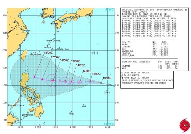
Latest JTWC track forecast

Forecast map for track and intensity

Update: October 16, 2015

Latest data from reliable computer models indicates a hit on Luzon on late Sunday noon PHT. Expected wind speeds at impact will be 180-220 km/h. The cyclone will weaken after impact but the major worry is the torrential downpours on northern Philippines for 3 days. Koppu will linger over Luzon for 72 hours.

It is expected to make landfall into Guangdong province of China on October 24.

Taiwan will not be affected except for showers in southern part of the island on October 22-23.

Update: October 15, 2015

The JTWC predicts in its latest bulletin that the violent typhoon will hit Luzon on Saturday afternoon with winds of 180-220 km/h.


Update: October 15, 2015

It is now certain that typhoon KOPPU will slam into Luzon in northern Philippines on October 18, 2015.  Not just touch the northeastern part of Luzon as some forecasts were saying but move right through it. Manila will be directly hit.

The storm is going to rapidly intensify in the next 48 hours.

KOPPU will take 2 days to move past Luzon so flooding torrential rains accompanied by strong winds can be expected October 18-20.

Thankfully the cyclone will weaken before hitting Philippines.

After Philippines?

Where will KOPPU go after Luzon? Models differ. Some predict a weakened KOPPU will move close past Taiwan on October 22-23. Other models say it will make landfall into China at northern Guangdong or southern part of Fujian province on October 22.

Water vapor satellite image of tropical storm KOPPU at 0400 hours GMT October 15, 2015
-----------


Update: October 14, 2015, 1630 GMT

Typhoon Koppu will turn into a violent typhoon when it hits Luzon on October 18. Torrential ràins and 230-270 km/h winds expected.

Update: October 14, 2015

Though present forecasts by JTWC says KOPPU will move through the northeast tip of Luzon we believe it will hit the area head on October 18 and move though it in the next 24 hours thereafter. We also predict Taiwan will be hit directly on October 22.

But it is not going to be a very strong typhoon. A category 1 or 2 (at most) cyclone according Saffir- Simpson scale. Winds of 120 km/h.

Latest satellite image of typhoons KOPPU and CHAMPI and their expected track (October 14 forecast)


Update: October 13, 2015 (0930 GMT)

The JTWC in its latest bulletin predicts typhoon KOPPU will hit Luzon, Philippines on October 18 with winds of 220-270 km/h.

Update: October 13, 2015

There are two typhoons imminent in the western Pacific Ocean. Future typhoon KOPPU is a tropical storm and will intensify into a typhoon in the next 48 hours or less. It recently passed Northern Marianas as a tropical depression. Position at 0000 hours today was 15.6 N, 143.1 E.

Future typhoon CHAMPI is in the Micronesia Islands presently. Position at 0000 hours today was 12 N, 162.2 E.

CHAMPI is expected to swing north in a couple of days harmlessly.

KOPPU is a cause of concern for the Philippines. Presently major forecast models differ as to its track. The intensity is not in doubt. It will be a category 3-4 ( may be 5) hurricane by October 18.

As to its track. One model predicts a direct hit on Luzon in northern Philippines on October 18. It will then hover around Luzon for 24-36 hours and move north, weaken and hit Taiwan on October 20, 2015.

 Another model says it will come dangerously close to Luzon on October 18-19 but will then swing north. Taiwan may be in peril.

Stay with us for continuous updates.

Typhoon KOPPU latest image 2015 October
Recent satellite image showing future typhoons KOPPU and CHAMPI 

typhoon koppu track forecast october 2015
Track forecast for future typhoon KOPPU 


Present position of future typhoon Champi

Share this PostPin ThisShare on TumblrShare on Google PlusEmail This

2 Typhoons KOPPU and CHAMPI Likely in West Pacific


Typhoon Champi

Typhoon Koppu

Forecast models are hinting at the formation of two tropical cyclones in the west Pacific Ocean in the next 15 days.

Typhoon KOPPU will form first. It is likely to be a massive cyclone. It will pass close by Guam and then swing north bypassing Japan.

Typhoon CHAMPI is likely to form around October 22, 2015 in the South China Sea and hit Vietnam.

These are possibilities now. We will update as things happen.
Share this PostPin ThisShare on TumblrShare on Google PlusEmail This

Arabian Sea depression dissipating fast


Update: October 13, 2015

The Arabian Sea low pressure system is now moving towards northern Oman. But it will dissipate mid sea on October 15 near the coast.

Some rainfall is expected in northern Oman on October 15-16 as a result. There might be some showers in Muscat and Sur. 

UAE will remain dry.


Latest satellite image of Arabian Sea low pressure area

Rain forecast showing total precipitation till October 18. The purple and light blue colours denote heaviest rainfall


Update: October 12, 2015

Arabian Sea system 3A is a low pressure area now.

It will now move WNW in the next 2 days towards Oman and dissipate totally at sea on October 15. It might bring cloudy weather or a drizzle in some areas of northern Oman and Saurashtra. Balochistan may receive light showers because of a western disturbance and not 3A.

Update: October 11, 2015, 1130 hours GMT

Arabian Sea depression is dissipating fast.

It will weaken into a low pressure area by tomorrow. It will dissipate  completely by October 15. Its remains may drift on and bring light showers or just cloudy weather in northern Oman and coastal Balochistan by October 17.

Update: October 11, 2015, 0430 hours GMT

Arabian Sea depression unlikely to turn into a cyclone.

The JTWC says it is not going to intensify much. The system will move north till tomorrow and after that swing away towards Oman reaching the coast near Sur on October 15. It is expected that the depression will start weakening as it changes direction. Some forecast models expect to dissipate on October 13.

Some rainfall is expected in coastal Oman on Thursday. The JTWC expects some rains around Masirah. We think it may extend from Sur to Masirah coastal areas.

It is very likely that the system will dissipate completely mid sea on October 14 without bringing any rains to Oman.


----------------------

Latest (0900 hours GMT, October 10) JTWC bulletin believes the Arabian Sea storm may move to central Oman.

This system seems to be proving major forecast models wrong. It is proving the GFS and European models wrong.

Surprisingly the US Navy's NAVGEM and Japanese models are being proved right.

The JTWC seems to be giving the most accurate information.

We will keep you informed.

Gujarat and Sindh are not targets. We repeat. Gujarat and Sindh will not be affected.

The storm is likely to dissipate near central coastal Oman between Duqm and Al Khahil. One can expect very heavy rains in these areas starting October 15. This forecast is not to be taken as final. The system may head to any part of the Oman coast.


Share this PostPin ThisShare on TumblrShare on Google PlusEmail This

Hurricane JOAQUIN May Not Hit US: Latest Updates

Hurricane Joaquín  is giving authorities in many countries nightmares. It has already turned into a category 2 storm with winds in excess of 175 km/h and is likely to intensify even more.

It has already started battering central Bahamas as it inches closer. Friday will be the worst for that country as the fury of nature will stand atop the islands before moving into the Atlantic Ocean.

US authorities are already on high alert as most forecast models say the system will make landfall into the eastern seaboard just near New York on October 6, 2015. And another worrying aspect is that many weather experts say Joaquín could well turn into a category 5 howling monster.

The imagination boggles.

But one forecast model is going against the herd of computer models.

The European ECMWF in its latest data predicts the hurricane is not going to make landfall into the USA ( Or  Canada) but will move away harmlessly into the North Atlantic.

It will gives the creeps to the busy shipping lanes from Europe to North America but the USA will remain safe.

The ECMWF model has been uncannily accurate as compared to other forecast models, especially NOAA's GFS.

Time will tell.


Hurricane Joaquin latest updates satellite image
Hurricane Joaquin satellite image . 0715 GMT, October 1, 2015
Share this PostPin ThisShare on TumblrShare on Google PlusEmail This

Latest Forecasts/Updates


Popular Posts

Search This Site