Showing posts with label gujarat. Show all posts

Mumbai, Konkan Faces Deluge On September 24, 2016

SEPTEMBER 15, 2016, THURSDAY 

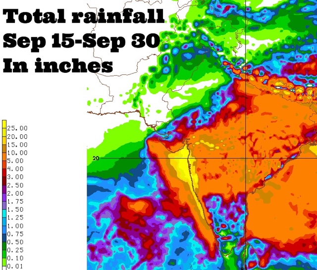
Coastal Maharashtra and the city of Mumbai are in for extremely heavy rains around September 24, 2016. Some forecast models suggest about 25 inches of rain in these places by the end of the month. 

The rest of Maharashtra, south Gujarat, some districts of Saurashtra and north, central Gujarat may also receive 2-5 inches of rain at that time.

This is going to happen because a Bay of Bengal cyclonic circulation will clamber over peninsular India, emerge near the Konkan coast in the Arabian Sea around September 24 and intensify into a well marked low pressure area.

Where will the low pressure system go after that? Hard to say now. Some forecast models say it will weaken and move into northern Maharashtra-western Madhya Pradesh. But this is not certain.

It might well decide to take a stroll in the Arabian Sea.
----
"Latest GFS forecast says the Arabian Sea low pressure system will hit northern Oman on September 29, 2016 with heavy rains."
----
Things are going to happen in the coming days in the Indian west coast. Mumbai. Prepare for floods. The GFS model says heavy showers in Konkan, Mumbai will start much before September 24. In the next few days. Heavy rains are expected in Maharashtra on September 17-18.

Very heavy rains are possible in Mumbai in next 72 hours. This will be just a precursor to the expected deluge on September 24.

Forecast models are predicting a sudden explosion of monsoon activity with two strong low pressure systems developing, one each in the Arabian Sea and Bay of Bengal around September 24, 2016. That day seems to be D-Day. Deluge day.

Situation presently is fluid. So it is hard to say where the rain systems will go. One thing is certain. Some places in South/West Asia are in for a lot of rains in the coming days.

Share this PostPin ThisShare on TumblrShare on Google PlusEmail This

Light Showers In Gujarat Till Sunday, Heavy Night Rains In Delhi

AUGUST 26, 2016, FRIDAY 
 
A low pressure area is forming off the Andhra Pradesh coast. We can expect heavy rains in the state in the coming days.
 
The cyclonic circulation over southern Rajasthan persists. But it has weakened as evidenced by low rainfall activity in Gujarat yesterday. But it will exert influence over the state till Sunday. Most parts will see dull drab weather with light rain.
Isolated heavy showers in central Gujarat around Khambhat, Kheda, Bharuch.
Intermittent showers in Kutch till Saturday night.
 
Light to medium rains in Kutch, Saurashtra in the next 48 hours. Bhavnagar, Surendranagar, Morbi, Amreli districts.
 
There might be a couple of heavy showers in Rajkot today late night.
 
Good showers in Kutch till early Saturday morning. Showers in Dwarka, Jamnagar districts Saturday morning.
 
Showers are expected in Andhra Pradesh, Telangana, Madhya Pradesh during the day till evening. Heavy rains may arise in Delhi, Haryana, Punjab, western Uttar Pradesh, northern Rajasthan late in the night till Saturday morning.
WARNING FLASH........CERTAIN PARTS OF SAURASHTRA (RAJKOT, SURENDRANAGAR, AMRELI, JUNAGADH, BHAVNAGAR) MAY SEE VERY HEAVY RAINS BEGINNING TONIGHT, LASTING TILL SATURDAY EVENING
 
 
Share this PostPin ThisShare on TumblrShare on Google PlusEmail This

Rains in Gujarat Till Saturday

AUGUST 25, 2016, THURSDAY

Under the influence of the weak cyclonic circulation presently over Rajasthan, isolated heavy rainfall will continue in Gujarat for next 48 hours. Parts of Saurashtra, Kutch and central Gujarat will be affected. Rains in Sindh on Saturday. The system will move to coastal Saurashtra by Saturday and then dissipate.

Heavy rains in Saurashtra (Rajkot, Amreli, Bhavnagar) till today midnight.

Very heavy rains in Kheda, Panchmahals, Anand, Vadodara, Sabarkantha districts till Friday evening.

Heavy showers in western Kutch on Friday-Saturday.

Showers in Sindh on Saturday.

Heavy rains possible in Dwarka on Saturday.

The GFS in contrast, predicts rainfall in Gujarat only till Friday morning. And that too only in Bhavnagar, Kheda, Ahmedabad, Surendranagar and maybe Morbi districts.

The circulation seems to have weakened considerably, contrary to expectations.

GFS FORECAST MAPS


Share this PostPin ThisShare on TumblrShare on Google PlusEmail This

August 8, 2016, Monday: Indian Monsoon Forecast Update

AUGUST 8, 2016, MONDAY

The cyclonic circulation which is presently hovering above southeastern Rajasthan will bring very heavy rainfall to the region and also parts of North Gujarat in the coming 72 hours.

Meanwhile the cyclonic circulation over Sindh has moved into the Arabian Sea. It will dissipate soon.

The Rajasthan rain system will intensify in the coming 24 hours and will die down on Friday, August 12.

The next major monsoon system to be born will be a low pressure area that will develop off the Odisha coast on August 16, 2016.

A smaller cyclonic circulation will form off the West Bengal coast on Tuesday, August 9.  It will move into Bangladesh, weaken and come over to West Bengal.

Heavy showers in Ahmedabad till Tuesday morning.

Very heavy rains in southern Rajasthan (Sirohi, Barmer, Abu, Udaipur, Mandsaur, Chittaurgarh) parts of north Gujarat (Palanpur, Mehsana), by Tuesday, August 9, morning.

Very heavy rains in Pali, Sirohi, Abu, Jhalor (Rajasthan) on Tuesday night.

Medium to heavy rains to continue in southern Rajasthan till Friday, August 12, morning.

Parts of north Gujarat (Palanpur, Patan, Mehsana) to receive medium to heavy rains till Wednesday morning.

Heavy rains in coastal WEST BENGAL, BANGLADESH (Chittagong) till Wednesday morning.


A cyclonic circulation is forming in the Bay of Bengal close to the West Bengal coast. It will move into Bangladesh and then into West Bengal. The system will bring heavy precipitation in these regions in the next 72 hours.

At 0630 hours today morning heavy rains occurring in Rajasthan. The rains will move to parts of north Gujarat and Kutch in the coming 48 hours.

Share this PostPin ThisShare on TumblrShare on Google PlusEmail This

August 6, 2016: Monsoon Forecast Update

AUGUST 6, 2016, SATURDAY

The cyclonic circulation over Gujarat will persist for another 36 hours. After that it will move to the Arabian Sea and then come back again to bring heavy showers to some districts of Saurashtra (Dwarka, Jamnagar, Rajkot) on Tuesday, August 9.

The Bay of Bengal low pressure area which is over Madhya Pradesh at present will move onto Rajasthan.

Heavy rains in Jamnagar, Kutch (Mundra, Mandvi, western Kutch) tonight.  Heavy showers in Sindh (Karachi) in next 24 hours. Heavy showers in northeast Gujarat (Godhra-Palanpur) tonight.

Heavy rains in Madhya Pradesh till Monday morning.

Heavy to very heavy rains in southeast Rajasthan (Kota, Bhilwara area) on Sunday night.

Very heavy rains in Uttar Pradesh on August 10-12.

RELATED: NOAA Rain Forecast Maps

RAIN RADAR AT 0930 IST SATURDAY shows it is raining heavily in Delhi, Vidarbha near Nagpur, Odisha, parts of Kutch and in coastal Sindh. By tomorrow the heavy rains will move into Madhya Pradesh and then onto Rajasthan under the influence of the Bay of Bengal cyclonic circulation system.

Share this PostPin ThisShare on TumblrShare on Google PlusEmail This

FLASH UPDATE: DELUGE IN GUJARAT SOON?

AUGUST 5, 2016, 1100 IST 

Earlier forecast models had been saying the Bay of Bengal low pressure system that is currently moving over Odisha, Chattisgarh would go to Rajasthan via Madhya Pradesh onto flood Delhi Haryana on around August 8, 9.

But latest forecast data from NOAA's GFS model says the system will not go to Rajasthan, Delhi but move to Gujarat.

If this happens a deluge awaits Gujarat from August 7, 2016. 

The GFS predicts very heavy rains in south, central, north Gujarat, Kutch and finally in coastal Sindh in the coming 3-4 days.

We are monitoring the situation and will constantly analyse data to see if this GFS prediction stays unchanged and is confirmed by other forecast models

We will provide constant updates.

UPDATE:AUGUST 5, 2016, 1230 IST 

The other reliable forecast models still insist the system will go to Rajasthan. Who is right? The next 24 hours will tell. We tend to agree with the other models. Let us see.

UPDATE:AUGUST 5, 2016, 1700 IST 

The GFS model in its latest data issued today at 0600 hours GMT still stays firm on its prediction. It says the flooding rain system will hit Central, South Gujarat on Sunday noon Indian Standard Time. One shudders to think of Valsad which is still reeling from flooding, if this monster rain system hits it on August 7.

UPDATE:AUGUST 6, 2016, 0730 IST 

Thankfully for Gujarat, it is now almost certain that the Bay of Bengal system will go towards Rajasthan via Madhya Pradesh. 

UPDATE: AUGUST 6, 2016, 1800 IST 

The GFS in its latest forecast issued today at 0600 hours GMT, says the rainmaker system over Madhya Pradesh presently will move to southern Rajasthan and then slink into north Gujarat area around Tuesday, August 9, and bring heavy rains there. Personally we think it is improbable. The GFS model is prone to make inaccurate forecasts at times.


Parts of Gujarat, especially South Gujarat, and parts of Saurashtra are still reeling from flooding rains from an upper air cyclonic circulation. Meanwhile another system from the Bay of Bengal is moving west. GFS model thinks it will hit Gujarat in 48 hours. The next 24 hours will tell if the nightmare situation will realise or not.


Share this PostPin ThisShare on TumblrShare on Google PlusEmail This

August 2, 2016: Monsoon Forecast Update

AUGUST 2, 2016, TUESDAY 

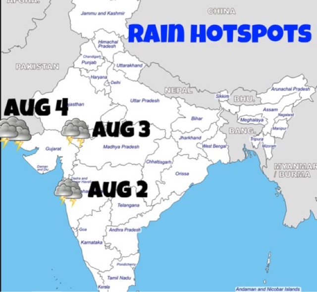
A low pressure system has formed in the Bay of Bengal. It will bring heavy rains to Odisha, Andhra Pradesh, Telangana, Chattisgarh, Madhya Pradesh. It will move onto Rajasthan on August 8.

Another low pressure system will form in the Bay of Bengal on August 9. Where it goes remains to be seen.

The upper air cyclonic circulation that is hovering over southeast Rajasthan will move to southern Sindh by August 4. The system will bring good rains to coastal Sindh on August 4, some districts of Saurashtra (Jamnagar, Dwarka, Porbandar, Kutch) on August 5, 6. There might be some showers in parts of North Gujarat and Kutch in the next 36 hours.

Intermittent heavy rains in Madhya Pradesh in next 5 days.

Heavy showers eastern Maharashtra (Beed, Yavatmal), Chattisgarh (Bhilai, Bilaspur), Telangana (Karimnagar, Warangal) till August 4 morning.

Heavy rains in Rajasthan, Kota-Udaipur area till morning of August 4.

Very heavy rains near Mumbai, Palghar, Ahmednagar, Thane, Nashik districts till Wednesday morning. Floods expected.

Some showers in parts of North Gujarat till tomorrow morning. Banaskantha, Sabarkantha, Mehsana and Patan districts.

Isolated heavy rain in Kutch district of Gujarat on August 6

Heavy rains in coastal Sindh, Karachi on August 4, Thursday.

Heavy showers in parts of Saurashtra on August 5-6, Friday, Saturday. Especially Dwarka, Jamnagar, Porbandar districts.

RELATED: RAIN FORECAST MAPS


1230 IST, August 2: Raining heavily near Mumbai as we had predicted. Rains are tapering off in south Gujarat. Soon heavy rains in Rajasthan in Udaipur-Kota area. The rains will move to southern Sindh, including Karachi on Thursday.


Presently raining near Mumbai, South Gujarat, pockets of Madhya Pradesh and Telangana, Chattisgarh.

Share this PostPin ThisShare on TumblrShare on Google PlusEmail This

Gujarat, Sindh Still Waiting For Rains

JULY 27, 2016

Half of the monsoon 2016 season has gone yet Gujarat and Sindh are still waiting for the rain gods. Neighbouring Maharashtra, Madhya Pradesh and most parts of Rajasthan have received good rainfall till now but due to the quirks of nature except for Dang and Amreli districts, Gujarat has been left mainly high and dry.

Looking forward, good rains are expected in central and north Gujarat on July 27-29. There might light showers in the rest of the state.
-----
"La Nina event, which affects rainfall and temperatures in the tropics, may develop in the third quarter of the year but it is likely to be weak and far less intense than El Nino that ended in May"
------

The next hope is the expected cyclonic circulation that is expected to form over the state around August 3. It will arise in northern Madhya Pradesh on August 2 and then drift over to north Gujarat on August 3. It is likely to hover over the region for days. It may bring good rains to north Gujarat and the parched Kutch region. Even Sindh may receive good precipitation then.

The GFS forecast model is forecasting the formation of a strong low pressure area off the Andhra-Odisha coast on August 6, 2016. It further says the system will cut through Andhra, Telangana, Chattisgarh, Madhya Pradesh, Maharashtra and reach Gujarat around August 9 bringing heavy rains everywhere.

The European model ECMWF expects the system to form earlier, on August 2, near the Myanmar coast. It says it will then intensify into a depression/deep depression by the time reaches the Odisha coast on August 3-4, and knock on Vidarbha's door by August 6. Powerful system.

Looks like the monsoon is really going to change gears in August. La Niña effect?

But 10 days is a long time in weather forecasting. Let us wait and observe.

UPDATE JULY 28

Hardly 24 hours have passed and the GFS is having doubts about the expected Bay of Bengal low pressure area. Our advice would be take GFS forecasts with a big pinch of salt. The good news is the European model persists with the forecast of an intensification of monsoon activity from August 2. Good rains are expected in dry Kutch-Sindh region around August 4-5.

Monsoon forecast GFS India August 2016
As the cyclonic circulation gives rain to Kutch on August 4, the much bigger monster system grows in the Bay of Bengal.

GFS believes this system will enter Andhra-Odisha on August 5-6, other models predict an earlier entry


Share this PostPin ThisShare on TumblrShare on Google PlusEmail This

Heavy rains in Gujarat, Rajasthan, Sindh till July 13

JULY 10, 2016


The center of attraction presently is the rain system which is flooding Madhya Pradesh since the last few days. The engine of this rain system is a low pressure area which was born in eastern Uttar Pradesh and is presently hovering above north central Madhya Pradesh.

Though this upper air cyclonic circulation will dissipate in a couple of days, the accompanying rain system will drench northern Maharashtra, central, north Gujarat, parts of southwest Rajasthan, Kutch, Sindh in the coming days.

On Sunday, July 10, the drenching will occur in north Maharashtra. On July 11 the heavy showers will move into central and parts of north Gujarat. On July 12 the action will shift to some parts of southwest Rajasthan and Kutch. Coastal Sindh, including Karachi is in for significant rains on July 13, Wednesday.  

The GFS expects 10-20 inches of rainfall in central Gujarat, 2-5 inches in north Gujarat and Sindh in the coming 3 days.

Saurashtra will be left relatively rainless.

Strange and unpredictable is the monsoon this year with renowned numerical forecast models like the GFS and European ECMWF struggling to give accurate forecasts for even 24 hours.

Meanwhile there is bad news for folks in South Asia and Middle East. The much awaited rain giver La Niña has not yet been born. Though the dreaded El Niño died an unsung end in May 2016, conditions are ENSO neutral presently.  In other words though El Niño is no more, La Niña is yet to rise. The Climate Prediction Center, an US agency says there is a 60% chance of La Niña in July-August-September and 70 % possibility during August-September-October. 

The moment La Niña is born and grows up South Asia is in for torrential rains.

Incidentally I happened to glance at the CFS forecast for South Asia for the months of August and September. I was surprised to see wave after wave of rain systems emerging from the Arabian Sea and hitting western India. 

The CFS week-by-week prediction was disappointing. It expects rains in Gujarat till July 15. After that all of India is in for below average precipitation till August 7, except for Bihar, Bangladesh, parts of Tamil Nadu, Andhra Pradesh.

LATEST NMME FORECAST FOR AUGUST 

Below is the rain forecast (above, below average) for South Asia by the NMME, The North American Multi-Model Ensemble model. It reiterates below average (orange) rainfall in parts of central and eastern India.


CFS FORECAST FOR AUGUST 

Meanwhile the Climate Forecast System, CFS, paints a gloomier picture. It says only the southern states of India and Bangladesh will receive good monsoon rains in August. For the rest of India it is orange, orange. Below normal precipitation.


Share this PostPin ThisShare on TumblrShare on Google PlusEmail This

Canadian model predicts good Indian monsoon rains in July

JULY 2, 2016

The latest monthly rainfall forecast by the Canadian CANSIPS seasonal model for July 2016 for India is out. It basically says the same thing as it said in June. That good monsoon rains are expected in northern, western and southern parts of the country.

Only the eastern states will have deficient below average rains. Karnataka Gujarat and Rayalseema will receive heavy precipitation in July. Pakistan, Oman and UAE will receive above average precipitation. Bangladesh will remain relatively dry.

This is largely corroborated by NOAA's CFS (Climate Forecast System) weekly forecast for July. It predicts a deluge in western India, especially in Gujarat between July 2-9. We have already predicted in an earlier post that a low pressure area may bring flooding rainfall to Madhya Pradesh and Gujarat around July 8, 2016.

Worryingly the CFS forecasts very poor precipitation throughout India in the last fortnight of the month.

Water scarce Gujarat is pinning its hopes on the July 8 low pressure system.


Share this PostPin ThisShare on TumblrShare on Google PlusEmail This

Gujarat, Sindh To Receive First Heavy Rains From June 29-30


JUNE 27, 2016

Progress of monsoon into Gujarat has been sluggish. It has covered half the state and stopped. This is because a big rain system moved into the Arabian Sea instead of moving into the state. It gave good showers to coastal Saurashtra and moved into the north Arabian Sea and lies as a low pressure area dumping precious water into the sea. The system will hover around and dissipate in mid sea without benefitting Gujarat, Sindh or Oman.
............
The low pressure area over north Arabian Sea has intensified into a tropical cyclone 02A. But as we have predicted earlier it will subside in the sea itself in a couple of days. 

We are monitoring the storm and will update you on fresh developments.
..............


But rescue is at hand for parched Saurashtra Kutch Sindh. The Bay of Bengal will hurl another big rainmaker which will move through Andhra Pradesh, Telangana, Vidarbha, western Madhya Pradesh, Gujarat, Kutch and finally reach coastal Sindh on June 30.

The Bay of Bengal is going to throw out another bigger rain system that will push monsoon into entire India. The system will end up over Rajasthan or Gujarat on July 5-6.

I guess this will because La Niña is on the rise. Drenching rains are on the cards in early July as monsoon will change gears.

Welcome July. Welcome La Niña.


Share this PostPin ThisShare on TumblrShare on Google PlusEmail This

Monsoon To Intensify From June 18, 2016

,

JUNE 13, 2016

Monsoon has been quite dormant after the push into Kerala, Karnataka and parts of Andhra Pradesh a few days back. Nothing dramatic is expected in the next 2-3 days except that it may move into Goa and some parts of North East India. Even the Goa part seems doubtful at present.

The Center of attraction is the Indian north east. Assam, Meghalaya, Arunachal Pradesh, Tripura, Mizoram, Manipur and Nagaland. It is going to rain cats and dogs here for at least the next three days. I guess it is monsoon entering in the area.

But from June 18, things are going to change elsewhere too. It will because of two circulations. One off Goa in the Arabian Sea. The second in the Bay of Bengal at the Andhra Pradesh coast.
..........
...........

The monsoon will get very vigorous over Goa and northern Karnataka from June 18-19. Very heavy precipitation is expected in these regions. The rains will then move into the rest of Andhra Pradesh, Telangana and parts of Maharashtra.

After that it is possible the monsoon may enter Mumbai, touch Gujarat and Madhya Pradesh.

There is a strong possibility of a low pressure area developing near the Goa coast on June 18-19. This system will have a lot of rain to throw. But present indications are that instead of moving north to Mumbai it will wander off in the sea. Where it goes is to be seen. Gujarat? Pakistan? Or head west towards Oman?
Share this PostPin ThisShare on TumblrShare on Google PlusEmail This

Rainfall activity to be vigorous over Karnataka, Goa coast in coming days

Monsoon rain India
Image credit: Political Indian 

JUNE 4, 2016

The progress of the monsoon in 2016 will be undramatic this year. No drenching depression or tropical cyclone that will propel it into India. Just slow incremental progress. A tortoise not a hare.

Update, June 6: NOAA says MJO, Madden Julian Oscillation, will become active in Indian Ocean from June 8, hence monsoon will become vigorous soon. It also says possibility of a tropical cyclone in South China Sea is receding. 

Numerical weather prediction, NWP, models have been giving out erratic, inconsistent predictions. Just yesterday the European model hinted at a depression or a tropical cyclone in the Bay of Bengal. In today's data, there is none.

After analysing data from various models we have some insight into what is going to happen on the monsoon front in the coming days.

Rainfall activity after a few days will fizzle out on the eastern coast states like Andhra Pradesh and Odisha. Though the northeastern states will remain wet. Monsoon should enter there in a few days.

Though some models see a different future for Andhra Pradesh. According to them rainfall will remain over the state till June 10 when a low pressure area may form off the coast. The system will move through the Bay of Bengal and drench northern Myanmar/Chittagong area after a couple of days.

But this scenario is not supported by the multi-model ensemble forecast. The rainfall forecast map valid till June 9 shows significant precipitation only in Karnataka, Kerala and Indian north eastern states.

The focus of attention will be the Arabian Sea coast of India. Karnataka is going to be pounded by rains for days. Coastal Karnataka and Goa will see increasing rainfall activity. This will slowly spread to Konkan and then Mumbai.

Monsoon may knock on its door on June 13-14 along with rest of Maharashtra. Gujarat on June 18-20.

Looking at rainfall forecast maps issued by NOAA's model we can say that by June 20, the rainy season will have started in Bihar, Jharkhand, Chattisgarh, Maharashtra and Gujarat. We are talking here of the northern limit of monsoon's progress.


Share this PostPin ThisShare on TumblrShare on Google PlusEmail This

May 2016: Extreme Weather Forecast And Possibilities, Updates

WET MONTH FOR OMAN AHEAD?
May 5, 2016

Oman and perhaps the UAE are in for a stormy wet month if forecast models are to be believed. By the last week of May, a low pressure/depression is likely to move into central Oman bringing heavy rains. 

Then by June 10, 2016 a powerful tropical cyclone may hit northern Oman. This storm is likely to form around June 5, 2016 near the Kerala-Karnataka coast of India.

These predictions are based on the CFS (Climate Forecast System) model created by the US agency CPC (Climate Prediction Center) and thus are nothing to sneeze at.

Though one cannot say 100% that a cyclone will hit Oman, since the CFS forecast has been persistently foretelling a storm since the last 10 days, there is a good possibility of a tropical cyclone in early June developing in the Arabian Sea. Where it goes remains to be seen.


US AGENCY CPC SAYS NO CYCLONE TILL MAY 17
May 4, 2016

The CPC, the US agency says in it's latest forecast that though there will be increased rainfall in southern Arabian Sea, a cyclone is unlikely till May 17.

Please note that the CFS model has been developed by the CPC.

It says....

"During Week-2, the CFS and ECMWF models agree that above-median rainfall will continue across the Horn of Africa and western Indian Ocean. Above-median rainfall forecast across far southern India, Sri Lanka, and parts of the central Indian Ocean is related to the potential for a developing MJO by mid-May. 

Tropical cyclone development is unlikely across the global tropics during the next two weeks. This inactive period for tropical cyclone genesis is typical for early May."


STORMS BREWING IN ARABIAN SEA IN END MAY
May 4, 2016

Latest CFS weekly forecasts indicate intense thunderstorm activity in the Arabian Sea off the coast of Oman after May 15, 2016. It is to be seen if it throws out a cyclone.


MONSOON WILL PUSH IN AROUND MAY 15
May 4, 2016

Below is the GFS forecast for May 15, 2016. It shows the high altitude 150 hPa winds. The easterly jet stream has been pushed up and the monsoon winds are arriving in the Andamans and Nicobar Islands.


TROPICAL CYCLONE UNLIKELY TILL MAY 22
May 4, 2016

The chances of a tropical cyclone developing in either the Arabian Sea or Bay of Bengal till May 22 seems remote. The CFS which had been hinting at a Arabian Sea storm by May end says today in its data that a cyclone is now likely in the Bay of Bengal in mid June. 

This has to be taken with a pinch of salt. Cyclones are inherently unpredictable. And May-June being storm seasons anything can happen anytime.


FORECAST TILL MAY 22
MAY 3, 2016

This is from IITM (Indian Institute of Tropical Meteorology, Pune)

The next 20 days forecast indicates that
Subsequent to the likely rain spell over major parts of India during the first pentad,  heat wave conditions are likely to re-develop over parts of east & central India (viz., Gangetic west Bengal, Odisha, Vidarbha and Telangana) during 7th – 11th May.  This is likely to intensify and spread over to cover major parts of central and adjoining peninsular India and northwest India, during the period, 12th – 21st May.

Cyclogenesis is un-likely over the north Indian ocean during 2nd – 21st May.

However, cross equatorial flow in the lower troposphere is likely to reach south bay of Bengal and adjoining Andaman Sea around 15th May.

Likely eastward propagation of  the convective phase of MJO across the Indian ocean may cause a pre-monsoon rainfall peak, with above normal rainfall activity over extreme south peninsula during 12th – 21st May.

Western Disturbances are likely to cause above normal precipitation over western Himalayan region during 2nd – 6th May and 12th – 16th May.

CYCLONE ROANU IMMINENT AT MONTHS END?
May 2

Is a tropical cyclone brewing in the Arabian Sea?
Yes, if the Climate Forecast System, run by an US agency is to believed. 
The CFS though a climate forecast model gives daily updates. And it's data has been suggesting a cyclone forming near the Kerala coast around May 23, 2016 for the last few days.
The tropical cyclone ROANU will be a massive one and it will traverse northward in the Arabian Sea for a week.
At one time it seems it will hit Oman but it will swerve and hit Pakistan on June 1, 2016.
At present it is a mere possibility.
Support from weather models like the GFS and ECMWF is awaited.
Though the GFS in today's forecast data says a low pressure is likely to develop near the Indian Kerala coast on May 18.

Cyclone ROANU Arabian Sea
Share this PostPin ThisShare on TumblrShare on Google PlusEmail This

Rains Coming To Rajasthan, Punjab, Kashmir, Himachal Soon

The Bay of Bengal depression that drenched Gujarat for 4 days will weaken and move to Jammu Kashmir and Himachal Pradesh by Wednesday through Rajasthan, Punjab and Delhi.

The depression/low lies over northern Saurashtra presently near Halvad (See Storm Tracker). Under its influence heavy showers are expected in Saurashtra till late evening today. The rains will move to northern Gujarat tomorrow and then into Rajasthan.

By Wednesday (September 23, 2015) the rains will quickly move through the state and then Haryana, Punjab, Delhi and Jammu Kashmir. Heavy rains are possible on Wednesday-Thursday in Jammu Kashmir and Himachal Pradesh.

The following are the GFS rain forecast maps for September 21, 22, 23. The figures are in mm.


Rainfall Forecast till 1200 GMT, September 21, 2015

Rainfall Forecast till 1200 GMT, September 22, 2015

Rainfall Forecast till 1200 GMT, September 23, 2015

Share this PostPin ThisShare on TumblrShare on Google PlusEmail This

Heavy Rains Likely in Western And North India: Forecast Models Differ On Where In Gujarat

The depression that originated in the Bay of Bengal has reached Vidarbha in Maharashtra presently. As a result showers are occurring in western parts of the state.

One thing is sure. In the next 5 days the system will move through Gujarat, Rajasthan, Haryana, Punjab and reach Jammu and Kashmir. It is expected to weaken after leaving Gujarat on September 22, 2015 but the mentioned states will receive good rainfall.

Low pressure area rain track forecast gujarat rajasthan september 2015
The GFS forecast on track and rain forecast of the low pressure area

The confusion lies in where it will rain in Gujarat under the influence of this system. Forecast models differ.

The GFS predicts the depression will weaken from the present 996 Mb system to 1002-4 system in a day or two. A mere low or an upper air cyclonic system. It says only south, central and parts of north Gujarat will get any significant precipitation. Saurashtra-Kutch will be left mainly dry.

The European ECMWF model foresees a stronger system. That the present depression will remain a 994 Mb system as long as it hovers above Gujarat. A stronger system means more rains. It also predicts that the low will move to Kutch and then onto Rajasthan. So this model predicts more rains in Saurashtra and Kutch.

See Detailed Rainfall Forecast Maps

Track The Storm

Satellite image of the low pressure area approaching western India. Image taken at 0530 hours GMT, September 18, 2015

Share this PostPin ThisShare on TumblrShare on Google PlusEmail This

Depression 99B To Bring Heavy Rains To MP, Maharashtra, Gujarat By September 20, 2015

The depression 99B that has formed in the Bay of Bengal and presently flooding Odisha has stamina. If forecasts are to be believed this system is not only to bring heavy rains to Chattisgarh, southern Madhya Pradesh, Vidarbha, northern Maharashtra, South and central Gujarat, and Saurashtra in the next 5 days but will in fact intensify from a 997 Mb storm to a 994 Mb storm when it hovers over Saurashtra on September 21, 2015.


It has just crossed the Odisha coast and bringing heavy precipitation to the region. In the next  72 hours it is going to reach Gujarat. On September 20, 2015 it will move onto Saurashtra and then hover over the region for a day or two and then abruptly move towards western Rajasthan and onto Haryana, Delhi and even Kashmir. Heavy rains are expected in these states till September 26.

The above was the American NCEP forecast. The European forecast differs on the track for the low pressure 99B. It predicts it will move into Sindh after Saurashtra and move north right through Pakistan. if the ECMWF model proves to be accurate then Pakistan is in for very heavy rains from September 22 onwards. And the system is expected to traverse throughout the country.

But that possibility seems to be receding. The latest data from the model says 99B will suddenly weaken on September 22, 2015 as it leaves Saurashtra and enters the Arabian Sea and then drift back through northwest Gujarat into Rajasthan and further into northern India before dissipating.

Wherever it goes 99B has a lot of energy and it will flood many areas before it peters out. And that is not expected for another 10 days.

Keep  in touch for latest forecasts for 99B. It has the computer models confused and they have been giving out different track forecasts with successive bulletins.

Big rain-maker system 99B needs to be closely monitored.

See Detailed Rainfall Forecast Maps

Track The Storm

Depression/low 99B over Odisha. Latest satellite image 0400 GMT September 16 2015
Depression/low 99B over Odisha. Latest satellite image taken at 0400 GMT, September 16, 2015

Share this PostPin ThisShare on TumblrShare on Google PlusEmail This

Massive Tropical Cyclone (Ashobaa) To Hit Gujarat May 21, 2015?

LATEST UPDATE MAY 16, 2015

There is no possibility of a tropical cyclone developing in either the Arabian Sea or Bay of Bengal in the coming next few days. Please read our latest forecasts and do not go by earlier articles.
+++++++++++++++++++++++++++


 It is possible that a powerful cyclone (Ashobaa) may soon form in the Arabian Sea in North Indian Ocean, which will intensify and make landfall into Gujarat state of Western India on May 21, 2015.

At presently only the reliable American GFS forecast system predicts this storm but we have seen from experience that generally GFS forecasts are accurate. We shall closely monitor the situation and keep you updated with latest forecasts as soon as we come across them.

According to the GFS, the cyclone will start off as a low pressure area on May 17, near the Karnataka-Kerala coast and then move north and intensify into a tropical cyclone (Ashobaa). The storm is likely to hit Gujarat on May 21, 2015.

We will monitor future GFS forecasts and see if the cyclone formation is sustained. We shall also observe the European Forecast Model and see whether it supports the GFS prediction.

The situation being fluid, we have to wait and see if the cyclone forms and what its track turns out to be. Gujarat, Pakistan or Oman?

Keep in touch for latest updates.

tropical cyclone ashobaa arabian sea gujarat may 2015
FORECAST MA SHOWING ARABIAN SEA CYCLONE ASHOBAA HITTING GUJARAT ON MAY 21, 2015

Share this PostPin ThisShare on TumblrShare on Google PlusEmail This

Last Update: End of Cyclone Nilofar at sea


The once powerful storm is no more. Nilofar died last night in the dark waters of the Arabian Sea. It is a depression now. It will disappear in a few hours.

The fears of the Sindh and Gujarat governments were unfounded after all. All Nilofar will offer is rough seas for 24 hours, a few showers in Sindh and some winds (a paltry 20-30 Kph off the coast of Sindh and Kachchh.

No heavy rains, no devastating winds. Nothing.

Nilofar may have died suddenly but two more storms are coming in the next 10 days. Cyclone Priya (Ashobaa?] may come calling to Tamil Nadu. Typhoon Nuri will head for Japanese shores.

Tropical Storm Vance is taking a stroll in the eastern Pacific before giving Mexico a visit.

Keep reading this site for the latest.
Share this PostPin ThisShare on TumblrShare on Google PlusEmail This

Cyclone Nilofar Will Weaken Before Hitting Kachchh-Sindh: Strong Winds To Lash Oman Tomorrow

XWF-WEATHER FORECAST MAP: Cyclone Nilofar on Thursday evening. It will be at its strongest then. After that it will rapidly weaken before landfall

Nilofar cyclone may throw up awesome winds of 200-240 Kph tomorrow but by the time it makes landfall at Kachchh-Sindh it will weaken considerably.

Both the GFS forecast and JTWC forecast agree that the storm will weaken before landfall.

The GFS says landfall will be on October 31, 2014.

JTWC says it will be on November 1, 2014.

Both agree that at landfall winds will be about 65-90 Kph.

Nilofar will bring rains to Kachchh (Gujarat) and southern Sindh. Karachi is in for rains and winds of 80 Kph on October 31-November 1.

What about Oman? Cyclone Nilofar is not going to hit Oman. It will receive some rains and strong winds of 80-90 Kph tomorrow.
Share this PostPin ThisShare on TumblrShare on Google PlusEmail This

Latest Forecasts/Updates


Popular Posts

Search This Site