Showing posts with label Konkan. Show all posts

Arabian Sea Low Off Saurashtra Coast By June 16

JUNE 10, 2017, SATURDAY 

Monsoon has already reached Goa and is preparing to hit hard at its next targets: Konkan and North Bengal.

The Bay of Bengal low pressure area will cross the Bangladesh coast by morning of June 12, Monday. Very heavy expected in the country from tomorrow itself. But the system may fizzle out in northern Bangladesh or in Assam, so it will bring heavy flooding rains to entire Indian north eastern states and will push monsoon into sub Himalayan West Bengal only. After that monsoon will lose steam. Bihar will have to wait.

The real action is going to happen in the Konkan region of Maharashtra. After Goa, monsoon is going hammer and tongs at Konkan. Very heavy rains expected in this region from Monday. Monsoon will arrive in Mumbai too.

But the real game changer may turn out to be an Arabian Sea low pressure system that may rise near the Dwarka coast of Saurashtra, in Gujarat state on June 16. It will start off as an cyclonic circulation off the Konkan coast by Monday then move to the seas off Saurashtra by 16, intensifying into a low.

Where it will go is not known now. It may drench Gujarat. It may move into Pakistan and drench it. It may move towards Oman. Or it may fizzle out mid sea.

This system is going to be a game changer.


Share this PostPin ThisShare on TumblrShare on Google PlusEmail This

Mumbai, Konkan Faces Deluge On September 24, 2016

SEPTEMBER 15, 2016, THURSDAY 

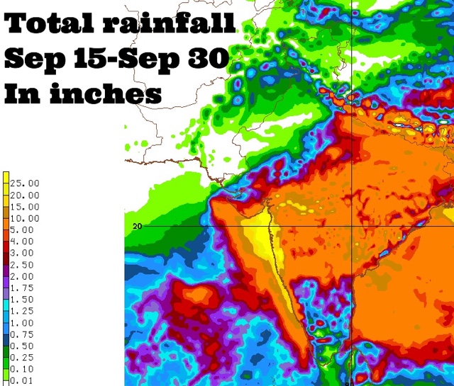
Coastal Maharashtra and the city of Mumbai are in for extremely heavy rains around September 24, 2016. Some forecast models suggest about 25 inches of rain in these places by the end of the month. 

The rest of Maharashtra, south Gujarat, some districts of Saurashtra and north, central Gujarat may also receive 2-5 inches of rain at that time.

This is going to happen because a Bay of Bengal cyclonic circulation will clamber over peninsular India, emerge near the Konkan coast in the Arabian Sea around September 24 and intensify into a well marked low pressure area.

Where will the low pressure system go after that? Hard to say now. Some forecast models say it will weaken and move into northern Maharashtra-western Madhya Pradesh. But this is not certain.

It might well decide to take a stroll in the Arabian Sea.
----
"Latest GFS forecast says the Arabian Sea low pressure system will hit northern Oman on September 29, 2016 with heavy rains."
----
Things are going to happen in the coming days in the Indian west coast. Mumbai. Prepare for floods. The GFS model says heavy showers in Konkan, Mumbai will start much before September 24. In the next few days. Heavy rains are expected in Maharashtra on September 17-18.

Very heavy rains are possible in Mumbai in next 72 hours. This will be just a precursor to the expected deluge on September 24.

Forecast models are predicting a sudden explosion of monsoon activity with two strong low pressure systems developing, one each in the Arabian Sea and Bay of Bengal around September 24, 2016. That day seems to be D-Day. Deluge day.

Situation presently is fluid. So it is hard to say where the rain systems will go. One thing is certain. Some places in South/West Asia are in for a lot of rains in the coming days.


Share this PostPin ThisShare on TumblrShare on Google PlusEmail This

Bay of Bengal Low Will Move To Arabian Sea September 18, 2015

Bay of Bengal low pressure area September 2015The Indian monsoon is withdrawing but storm activity has begun in the Bay of
Bengal with a low pressure area forming. This system is going to hover around near the Andhra coast for the next 5 days bringing rains to peninsular India especially in Odisha, Andhra, Telangana and northern Karnataka.

The low will then traverse west through India and hop into the Arabian Sea on September 18, 2015. Increased rainfall is expected in Konkan coast by then.

The low in the Arabian Sea may intensify into a depression and will move close by the coast of Saurashtra till September 24.

After that it will swing back into the open sea and move to northeastern coast of Oman. It will be gradually weakening all that time so Oman may expect some showers by September 27.

The European Model too supports increased storm activity near the Konkan coast around September 18-20, but it is not as hopeful as the GFS that the system will intensify much.

The European model envisages another Bay of Bengal low/depression moving through Odisha, Chattisgarh, Bihar and onto Uttar Pradesh around September 22, but the GFS stays mum on the forecast.

So we see different forecasts by two computer models.

The point they agree upon is... A Bay of Bengal low pressure moving west reaching Arabian Sea around September 19, 2015. The rest is differing predictions.

Monitor North Indian Ocean (Arabian Sea, Bay Of Bengal) LIVE
Share this PostPin ThisShare on TumblrShare on Google PlusEmail This

Latest Forecasts/Updates


Popular Posts

Search This Site