Showing posts with label Mumbai. Show all posts

Arabian Sea Low Off Saurashtra Coast By June 16

JUNE 10, 2017, SATURDAY 

Monsoon has already reached Goa and is preparing to hit hard at its next targets: Konkan and North Bengal.

The Bay of Bengal low pressure area will cross the Bangladesh coast by morning of June 12, Monday. Very heavy expected in the country from tomorrow itself. But the system may fizzle out in northern Bangladesh or in Assam, so it will bring heavy flooding rains to entire Indian north eastern states and will push monsoon into sub Himalayan West Bengal only. After that monsoon will lose steam. Bihar will have to wait.

The real action is going to happen in the Konkan region of Maharashtra. After Goa, monsoon is going hammer and tongs at Konkan. Very heavy rains expected in this region from Monday. Monsoon will arrive in Mumbai too.

But the real game changer may turn out to be an Arabian Sea low pressure system that may rise near the Dwarka coast of Saurashtra, in Gujarat state on June 16. It will start off as an cyclonic circulation off the Konkan coast by Monday then move to the seas off Saurashtra by 16, intensifying into a low.

Where it will go is not known now. It may drench Gujarat. It may move into Pakistan and drench it. It may move towards Oman. Or it may fizzle out mid sea.

This system is going to be a game changer.


Share this PostPin ThisShare on TumblrShare on Google PlusEmail This

Arabian Sea, Bay of Bengal May Spawn 2 Systems September 23, But How Big?

SEPTEMBER 19, 2016, MONDAY
 
The two seas which hurl storm systems into India and South Asia, Arabian Sea and Bay of Bengal are going to spew two cyclonic circulations on September 23-24 in a burst of monsoon activity. The question is how durable and strong they are going to be?
 
Present forecasts present a mixed picture. 
 
The Bay of Bengal system will weaken (the usual story this monsoon) and meander through coastal Andhra, Odisha, Chattisgarh, Bihar, Uttar Pradesh and perhaps Madhya Pradesh. It will drench these areas as it passes them. But it will remain a mere cyclonic circulation, not a respectable low pressure area.
 
The Arabian Sea low will emerge from the waters off the Mumbai coast on September 23, 2016. It is is most likely it will hover over northern Maharashtra for a day or two, then go phut, fizz. There might be heavy rains in Mumbai on September 23-24, but that's it.
 
Other forecast models suggest the system will take a long walk in circles in northeastern Arabian Sea then weaken and potter off to central or southern Oman on September 29, 2016. The chances of it intensifying into a tropical cyclone is low at present.
 
Let us wait and see how things turn out.
 
Satellite image Arabian Sea Bay of Bengal September 19, 2016
Share this PostPin ThisShare on TumblrShare on Google PlusEmail This

Mumbai, Konkan Faces Deluge On September 24, 2016

SEPTEMBER 15, 2016, THURSDAY 

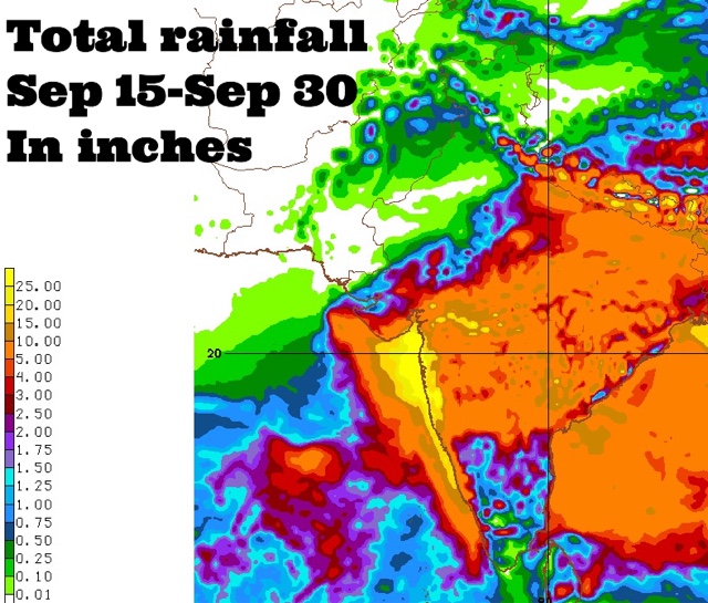
Coastal Maharashtra and the city of Mumbai are in for extremely heavy rains around September 24, 2016. Some forecast models suggest about 25 inches of rain in these places by the end of the month. 

The rest of Maharashtra, south Gujarat, some districts of Saurashtra and north, central Gujarat may also receive 2-5 inches of rain at that time.

This is going to happen because a Bay of Bengal cyclonic circulation will clamber over peninsular India, emerge near the Konkan coast in the Arabian Sea around September 24 and intensify into a well marked low pressure area.

Where will the low pressure system go after that? Hard to say now. Some forecast models say it will weaken and move into northern Maharashtra-western Madhya Pradesh. But this is not certain.

It might well decide to take a stroll in the Arabian Sea.
----
"Latest GFS forecast says the Arabian Sea low pressure system will hit northern Oman on September 29, 2016 with heavy rains."
----
Things are going to happen in the coming days in the Indian west coast. Mumbai. Prepare for floods. The GFS model says heavy showers in Konkan, Mumbai will start much before September 24. In the next few days. Heavy rains are expected in Maharashtra on September 17-18.

Very heavy rains are possible in Mumbai in next 72 hours. This will be just a precursor to the expected deluge on September 24.

Forecast models are predicting a sudden explosion of monsoon activity with two strong low pressure systems developing, one each in the Arabian Sea and Bay of Bengal around September 24, 2016. That day seems to be D-Day. Deluge day.

Situation presently is fluid. So it is hard to say where the rain systems will go. One thing is certain. Some places in South/West Asia are in for a lot of rains in the coming days.


Share this PostPin ThisShare on TumblrShare on Google PlusEmail This

Sluggish Monsoon Will Reach Mumbai On June 21-22, 2016

JUNE 16, 2016

The problem with monsoon 2016 is the Arabian Sea branch. It is sluggish, slow and lethargic. On June 8 it mustered its strength and managed to crawl into Kerala, Karnataka. But after that it seems have fainted again. It is yet to enter Goa.

In contrast the Bay of Bengal stream is vigorous. It threw out a tropical cyclone ROANU in May. While its western sibling is dithering, it has entered Indian NE states with a bang. It has reached Bangladesh and in the next 3-4 days it will advance into West Bengal, Odisha, Rayalseema, Telangana and Andhra Pradesh. It will push into Vidarbha and Marathwad soon.

All this time the Arabian Sea stream has gone to sleep. No low pressure areas or depressions. Just some miserable showers over Kerala, Karnataka and Goa.

But come June 18 and it will shake off its lethargy. Rains will increase off Kerala, then there will be a deluge over coastal Karnataka, Goa on June 19-20. 

But there is problem here too. The invigorated rain system over Goa will split in two. One wandering off west into the sea. Another slowly advancing into Konkan and Mumbai on June 22.

So do not expect a dramatic deluge in Mumbai with flooding rains on June 22. It will be a sedate affair.

Rainfall June 15 India monsoon 2016

Share this PostPin ThisShare on TumblrShare on Google PlusEmail This

Monsoon To Intensify From June 18, 2016

,

JUNE 13, 2016

Monsoon has been quite dormant after the push into Kerala, Karnataka and parts of Andhra Pradesh a few days back. Nothing dramatic is expected in the next 2-3 days except that it may move into Goa and some parts of North East India. Even the Goa part seems doubtful at present.

The Center of attraction is the Indian north east. Assam, Meghalaya, Arunachal Pradesh, Tripura, Mizoram, Manipur and Nagaland. It is going to rain cats and dogs here for at least the next three days. I guess it is monsoon entering in the area.

But from June 18, things are going to change elsewhere too. It will because of two circulations. One off Goa in the Arabian Sea. The second in the Bay of Bengal at the Andhra Pradesh coast.
..........
...........

The monsoon will get very vigorous over Goa and northern Karnataka from June 18-19. Very heavy precipitation is expected in these regions. The rains will then move into the rest of Andhra Pradesh, Telangana and parts of Maharashtra.

After that it is possible the monsoon may enter Mumbai, touch Gujarat and Madhya Pradesh.

There is a strong possibility of a low pressure area developing near the Goa coast on June 18-19. This system will have a lot of rain to throw. But present indications are that instead of moving north to Mumbai it will wander off in the sea. Where it goes is to be seen. Gujarat? Pakistan? Or head west towards Oman?
Share this PostPin ThisShare on TumblrShare on Google PlusEmail This

Rains To Advance Rapidly Into Indian West Coast By May End

MAY 15, 2016

EARLY MONSOONS

Rainfall activity is going to increase dramatically on India's west coast by the end of May, 2016.

Call it monsoon rains or pre-monsoon rains. We leave the technicality to the met department. But monsoon winds are going to advance rapidly up the west coast in the next 15 days. 

Knocking on the doors of Mumbai in 15 days.

How will this happen?

Firstly the present Bay of Bengal low pressure off the Tamil Nadu coast is going to push the rains into Kerala, Tamil Nadu, Karnataka, Andhra Pradesh. Perhaps right into the Indian northeast, Myanmar and Bangladesh.

So 91B is going to engine the monsoons into southern and eastern India. Or create favourable conditions for its onset.

Next the Arabian Sea branch will become active. Though it is uncertain if a storm system will develop or not, clusters of rain systems are expected to advance from southwest Arabian Sea into the Malabar coast. This is according to NOAA's GFS model forecast.

See the rainfall map below. It shows the expected accumulated precipitation by May 31, 2016. We see the Indian coast drenched with more than 25 inches of rain by month end. The yellow colors on the map.

Bay of Bengal Storm Updates


Monsoon rainfall May 2016
Share this PostPin ThisShare on TumblrShare on Google PlusEmail This

Rain-Maker Depression To Deluge Andhra, Maharashtra, Mumbai By September 20, 2015

We had predicted a low pressure/depression in the Bay of Bengal and Arabian Sea almost a week ago. The system will form on September 14, 2015 near the Andhra coast.

The Bay of Bengal is already showing increased storm activity in preparation of the birth of the rain maker weather system.

The low pressure area will form off the eastern coast of India near Andhra Pradesh and hover around for the next two days till September 18 bringing heavy rainfall in Andhra Pradesh.

It will then cross the coast and move through Andhra, Telangana, Northern Karnataka, Maharashtra onto Mumbai.

Very heavy rains are expected in Mumbai on September 20.

The low pressure area will then intensify again in the warm waters of the Arabian Sea into a depression/deep depression (Forecasts rule out a tropical cyclone presently, but 10 days is a long long time in weather forecasting. Anything can happen).

The depression is expected to move along the Saurashtra coast into the open sea and reach the coast of central Oman on September 23, 2015. Though the European model believes it will move into Gujarat on September 20. We have to wait awhile before the picture becomes clearer.

In a nutshell the low pressure area is going to bring very heavy rains to Andhra to Mumbai from September 14.

 A SECOND DEPRESSION IN THE BAY OF BENGAL?

A forecast model predicts a depression moving into Odisha on September 21, 2015, but this is yet to be confirmed by other models. It appears that the present low pressure area in the South China Sea is going to do a lot of travelling over Vietnam, Thailand and Myanmar and then hop over into the Bay of Bengal on September 19. This will then gain strength and become a deep depression and hit Odisha as we have said earlier. Chances are this predicted system has the makings of another tropical cyclone. As there are  10 more days to go and forecasts have the habit of changing in these many days.

Bay of Bengal depression Odisha September 21, 2015
The European Model predicts this low in the South China Sea will hit Odisha on September 21, 2015


Cyclone CHAPALA to from off Konkan coast on September 20, 2015?

Monitor Bay of Bengal, Arabian Sea LIVE

Bay of Bengal Arabian Sea depression low pressure area September 2015
The depression as seen on September 21, 2015, moving away from the Indian coast off Mumbai.

Share this PostPin ThisShare on TumblrShare on Google PlusEmail This

Little Chance Of Arabian Sea Cyclone For Now. Monsoons to get active in a week.

Heavy monsoon rains hit Kerala on June 13, 2014

The low pressure area in the Arabian Sea has drifted westwards towards the Horn of Africa. It did not develop into a tropical storm. By latest forecasts, the possibility of a cyclone developing in the Arabian Sea remains low.

We will inform at the earliest of any new developments.

The monsoons which are late this year will grow in strength and hit Kerala on the 13th of June, 2014. Mumbai has it's first date with the rains on June 17, 2014.

The monsoons reach Mumbai on June 17, 2014

-----------------------------------------------------


PS: According to the Canadian CMC model a low pressure area will develop in the Arabian Sea on June 8, 2014. But this is yet to be confirmed by other forecast models.

June 8, 2014: The Canadians say a low pressure area will form
Share this PostPin ThisShare on TumblrShare on Google PlusEmail This

Low Pressure Area May Grow Into A Cyclone In Arabian Sea: Or Monsoons Hit Mumbai June 15, 2014

June 13, 2014. The Arabian Sea Tropical Storm About To Hit Oman

A low pressure area has been spawned in the Arabian Sea. Area is 5 Degrees North, 68 Degrees East. This looks ominous. The timing is right. June. As we have said before the month of June is one when the North Indian Ocean gets restless and throws out a cyclone.

And when a low pressure area develops in the Arabian Sea in June. That spells trouble. The reliable GFS forecast seems to confirm our worst fears.

Yes.

A big bad storm has just been born. And the GFS forecast says it is going to grow into a big mean tropical storm. Where is it going to go? Oman.

The GFS forecast says that the low pressure area will gradually start moving northward along the Indian coast and gradually gain strength. Around the 10th of June, 2014, it will suddenly swing NW and hit Oman on June 13, 2014. The province which will face the brunt of the storm is Ash Sharqiyah.

May be Cyclone Nanauk is coming. After all.

But a word of caution. It is early days. The low pressure area may just fizzle out without developing into a significant storm.

Exploring this scenario further, if a storm fails to form, the monsoon system will move gradually up the Indian west coast and bring rains to Mumbai on June 15, 2015.

We will give you the latest forecasts and confirmation (Or otherwise) from various international sources.

Alternative scenario: No storm in Oman but monsoons reach Mumbai on June 15, 2014.

-----------------------------------------
MORE RAIN PREDICTION MAPS
 Alternative 1: Tropical storm hits Oman on June 13, 2014


Alternative 2: Monsoons hit Mumbai on June 15, 2015

Share this PostPin ThisShare on TumblrShare on Google PlusEmail This

Mumbai Is In For A Deluge From June 6, 2013

XWF RAIN PREDICTION MAP: JUNE 9, 2013: DELUGE APPROACHES MUMBAI

The monsoon is going to come early this year. And it is going to be vigorous.

Things are happening in the Bay of Bengal right now as monsoon winds enter it from the east. Within days Bay of Bengal is going to be laden with rain-bearing monsoon clouds.

Pre-monsoon showers are going to begin in the Indian west coast too within a few days. Dry Gujarat too will get light rains within a week.

But the forecast that interests us greatly is Mumbai. The metropolis is in for a huge deluge around June 9, 2013. This will be partly as a result of a Bay of Bengal low pressure area which will reach it on June 9. And partly because of a rain bearing system which is hovering around in the Arabian Sea since the last few days

This system will move towards the Oman coast in the next few days, bring southern Oman some rains on May 30, 2013. The system will then potter around near the Omani coast for some time and then start moving in an easterly direction towards the Indian coast.

June 9, 2013. The two systems will collide. And BOOM! Very heavy rains on the entire Indian west coast stretching from Gujarat to Goa. Mumbai will get very heavy rainfall for a few days.

Folks in Mumbai. Be prepared for a drenching on June 9, 2013.

Latest forecasts say the drenching in Mumbai will start from June 6, 2013 and continue for 5-6 days.

Keep reading this site for latest updates.
Share this PostPin ThisShare on TumblrShare on Google PlusEmail This

Latest Forecasts/Updates


Popular Posts

Search This Site