Showing posts with label Rainfall forecast. Show all posts

Mumbai, Konkan Faces Deluge On September 24, 2016

SEPTEMBER 15, 2016, THURSDAY 

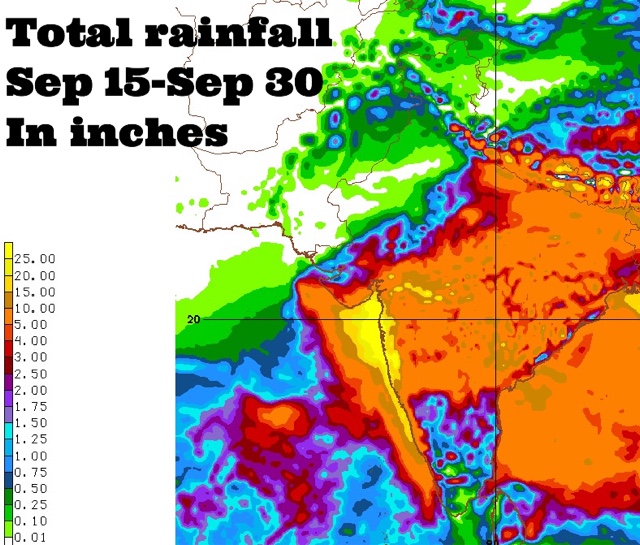
Coastal Maharashtra and the city of Mumbai are in for extremely heavy rains around September 24, 2016. Some forecast models suggest about 25 inches of rain in these places by the end of the month. 

The rest of Maharashtra, south Gujarat, some districts of Saurashtra and north, central Gujarat may also receive 2-5 inches of rain at that time.

This is going to happen because a Bay of Bengal cyclonic circulation will clamber over peninsular India, emerge near the Konkan coast in the Arabian Sea around September 24 and intensify into a well marked low pressure area.

Where will the low pressure system go after that? Hard to say now. Some forecast models say it will weaken and move into northern Maharashtra-western Madhya Pradesh. But this is not certain.

It might well decide to take a stroll in the Arabian Sea.
----
"Latest GFS forecast says the Arabian Sea low pressure system will hit northern Oman on September 29, 2016 with heavy rains."
----
Things are going to happen in the coming days in the Indian west coast. Mumbai. Prepare for floods. The GFS model says heavy showers in Konkan, Mumbai will start much before September 24. In the next few days. Heavy rains are expected in Maharashtra on September 17-18.

Very heavy rains are possible in Mumbai in next 72 hours. This will be just a precursor to the expected deluge on September 24.

Forecast models are predicting a sudden explosion of monsoon activity with two strong low pressure systems developing, one each in the Arabian Sea and Bay of Bengal around September 24, 2016. That day seems to be D-Day. Deluge day.

Situation presently is fluid. So it is hard to say where the rain systems will go. One thing is certain. Some places in South/West Asia are in for a lot of rains in the coming days.


Share this PostPin ThisShare on TumblrShare on Google PlusEmail This

Oman, UAE Not Dry This July-October Says US NMME Model

JUNE 8, 2016

The Middle East countries, especially Oman, United Arab Emirates, Qatar and parts of Saudi Arabia will not remain their usual rainless in the coming months in 2016. This is what the American climate forecast model the NMME predicts in its latest forecast issued today for July to October.
............
The North American Multi-Model Ensemble (NMME) is an experimental multi-model seasonal forecasting system consisting of coupled models from US modeling centers including NOAA/NCEP, NOAA/GFDL, IRI, NCAR, NASA, and Canada's CMC. 
.............
These countries receive hardly any rains from June to November. The average is a few millimetres in these months. But it is perhaps going to be different this year if the forecast by NMME is to be believed. It predicts an excess of 10-30mm of rainfall in each of the months. Please see the monthly forecast maps below. The figures are millimetres (mm).

For a country practically dry during this time of the year, an inch or two is substantial. Perhaps it will be an overflow from the bumper monsoon expected in India and South Asia this year.

Only October will see a dry period except for parts of Oman. Saudi Arabia will see spells of rainfall from July to September. Especially southern parts of the arid country.

A week earlier the Canadian CANSIPS model forecast had predicted a similar wet scenario for the region. We had said in the article......"Surprisingly, Middle East countries generally considered dry will remain wet in the coming months. Oman, UAE and Saudi Arabia will receive much above the average precipitation for the months of July, August and September in 2016."

We shall continue giving updates for Oman, UAE and Qatar. Not only seasonal forecasts but track developments if they happen. We mean a tropical cyclone or an Arabian Sea low pressure area wandering off towards the region.


Share this PostPin ThisShare on TumblrShare on Google PlusEmail This

Cyclone NILOFAR: How Will It Affect India and Pakistan?


Latest Infra-Red Satellite Image of Cyclone Nilofar : 1200 HRS GMT, October 29, 2014


The lady is in the Arabian Sea throwing out winds howling at 200-230 Kph. Cyclone Nilofar is slowly inching towards land. The lands affected will be India and Pakistan.

---------------------
LATEST UPDATE: The cyclone will start weakening from tomorrow (Thursday)
----------------------

The winds will be worst at the Kachchh and Sindh coast. The IMD says they will be 80-100 Kph. That is much better than 200 Kph. Look what Hudhud did to Vizag.

The winds will start from Thursday afternoon and continue till Saturday. Worst will be on Friday. Karachi is in for a battering with 100 Kph winds. Dwarka and Kachchh districts will get off with 60-80 Kph winds. But northern Kachchh (Koteshwar) will get a 100 Kph hammering.

The ports of Okha, Jamnagar (Bedi and Sikka), Navlakhi, Kandla, Mundra, Kandla will feel winds of 50-70 Kph on Friday

 Nilofar is going to bring rains. The heaviest will be in Sindh (Karachi included). Kachchh will get off with slightly less rain. Vagaries of nature!

Heaviest rains are expected in Sindh (SE parts, Karachi included). Flooding may occur.

In India rains are expected in Kachchh, west and north Rajasthan (heaviest around Bikaner and Jaisalmer). Showers expected even in Jaipur, Haryana and Delhi on November 1-2, 2014.

Rain Forecast Map: Cyclone Nilofar: From now till November 2, 2014


Total rainfall from Cyclone Nilofar: Where and how much?


Share this PostPin ThisShare on TumblrShare on Google PlusEmail This

CYCLONE HUDHUD UPDATE: How And Where Will It Affect India: Winds, Rainfall And Wave Surge


Latest forecasts say that Cyclone Hudhud is going to make landfall near Visakhapatnam on late Saturday evening. Though the winds will slightly less than feared earlier, they will be very strong. At time of impact the winds be around 190 Kph, gusting up to 230 Kph.

Another feature of this storm is that even after moving into India the winds will not subside suddenly. Even some districts of Chattisgarh will face winds of 60-80 Kph. Not to mention that heavy downpours.

Cyclone Hudhud is going to bring heavy rainfall to many parts of India. Odisha, Seemandhra, West Bengal, Chattisgarh, parts of Madhya Pradesh, Maharashtra and Uttar Pradesh.

The worst affected (Wind, rainfall) districts will be as follows,

ANDHRA: East Godavari, Visakhapatnam, Vijayanagaram, Srikakulam, Khammam
CHATTISGARH: Sukma, Dantewada, Bijapur, Bastar, Narayanpur.
ODISHA: Malkangiri, Koraput, Gajapati, Rayagada, Kalahandi, Nabarangpur

Waves Will Cause Sea To Enter Land For Kilometers

It happened during the 1999 super cyclone. It happened during Phailin. And it will happen within the next few days courtesy Cyclone Hudhud. Sea entering the coastal areas. Hudhud is going to whip up waves up to 12 meters along the coast at time of impact. So sea water will rush in inland, especially into low lying areas along the coast. Worst affected will be Visakhapatnam.

That is why the disaster authorities are evacuating people who live close to the coast.

Rainfall Forecast Map: Cyclone Hudhud is going to bring a lot rain to India (Map shows total precipitation till 17/10/2014)


Share this PostPin ThisShare on TumblrShare on Google PlusEmail This

Just One Point: Please Don't Question Our Integrity

Someone just wrote to us...."Kindly be accurate in giving out the information as this is a serious matter which needs to be addressed and prepared for. Just don't give the Prediction and projections unless it is positively CONFIRMED."

 We replied...."We know this is a serious matter. If one is looking for 100% confirmed forecasts, this is not possible in today's world even with the biggest supercomputers, as any meteorologist will tell you. If one is looking for greater accuracy, then wait for the weather bulletins by the country's Met office. What we do is give indications of a possibility of a tropical storm WELL IN ADVANCE. Sometimes we are proved wrong; Sometimes we are proved right. We are bloggers, not the country's official Met department. And our forecasts are based on real trusted forecast models, not our whims and fancies"
Link

Share this PostPin ThisShare on TumblrShare on Google PlusEmail This

Two Low Pressure Areas: Rains In Oman And West Bengal Expected

XWF WEATHER PREDICTION MAP: SATELLITE IMAGE TAKEN TODAY SHOWS THE TWO LOW PRESSURE AREAS, ONE EACH IN THE BAY OF BENGAL AND ARABIAN SEA (WILL FORM ON MAY 30)

Today we shall talk about two low pressure areas (LPA). One in the Arabian Sea, the other in the Bay of
Bengal. One has already formed. The other will take shape on May 30, 2013.

As we had forecasted earlier,  a low pressure has formed in the Bay of Bengal. We had also said that this system would make landfall two days later and bring heavy rains in Bangladesh and West Bengal. Well, there has been a slight change of plan. The LPA will not go straight into Bangladesh. But it will hover around for some time near the Orissa coast then move into land on May 29, 2013 at the Orissa-West Bengal border. It will then curve into West Bengal bringing heavy rains in the state for the next 3-4 days. North Bengal will get rains on June 1, 2013. Heavy rains, if I may so.
.
Then the system will drench north Bangladesh on June 2, 2013. I am talking of Rangpur, Dinajpur, Panchgarh and Thakurgaon.

The Arabian Sea LPA will form on May 30, 2013. It will move along the Oman coast in a northerly direction, giving rains to the coastal areas. Muscat may get some rains on June 4-5, 2013. It may rain in Abu Dabhi, Dubai and Doha around May 6, 2013. Muscat will get some good showers on June 5-6, 2013.
Share this PostPin ThisShare on TumblrShare on Google PlusEmail This

XWF-LRF: HEAVY RAINS IN OMAN ON JUNE 12, 2013

XWF-LRF: Heavy rainfall in Oman on June 12, 2013
We are making our first LRF (Long Range Forecast). Heavy rains are likely in Oman on June 12, 2013.This
will be the result of a low pressure area formed in the Bay of Bengal on June 6, 2013. By then the monsoons will have set in the Bay of Bengal. This low pressure area will travel through India (Orissa, northern Andhra Pradesh, Maharashtra) and then enter the Arabian Sea on June 9, 2013.

It will then move westwards and hit Oman on June 12, 2013.

Now please note that this is an long range forecast and prone to inaccuracy.

Let us wait and see how things pan out.

XWF-LRF RAIN PREDICTION MAP: COURSE (JUNE 7, 2013 TO JUNE 12, 2013) OF THE LOW PRESSURE AREA WHICH WILL BRING RAINS TO OMAN ON JUNE 12, 2013.

Share this PostPin ThisShare on TumblrShare on Google PlusEmail This

A Rain System Will Touch Southern Oman On May 30, 2013

Presently things are very boring in the North Indian Ocean after the departure of MAHASEN. It is only in the end of the month that the SE monsoons will start approaching South Asia. But there is another interesting development in the Arabian Sea. No it is not a cyclone, nor even a depression.


But I am talking of the mass of rain-bearing clouds in south Arabian Sea. They have been there for quite a few days now. Initially it was expected that they will give birth to a substantial storm.

But forecasts now say the system will start moving gradually towards the coast of southern Oman and give some rains on May 30, 2013. It will rain heavily in the next two days in the sea off the coast. Then this system will move in a  NE direction and bring heavy rains to the Saurashtra (India) coast on May 6, 2013.

There are still some days to go. Will the rain system behave as we have predicted? Or will it change its mind and turn into something more substantial?

Let us wait and watch.

Xtreme Weather Rain Prediction Map; May 30, 2013. Rainfall in southern Oman

Xtreme Weather Rain Prediction Map: June 2, 2013. Heavy rains off the coast of southern Oman

Xtreme Weather Rain Prediction Map: June 5, 2013. The system now reaches the Gujarat coast and brings heavy rains

Share this PostPin ThisShare on TumblrShare on Google PlusEmail This

Cyclone NILAM Will Bring Heavy Rains To Southern, Eastern and Parts of Central India.


Cyclone NILAM is powerful. It is a very moisture laden system and its inherent strength is going to being heavy rains to not only Tamil Nadu Eastern Karnataka, Andhra Pradesh but also to Orissa, eastern Maharashtra, West Bengal and parts of Madhya Pradesh in the next week.


Rainfall Prediction Map owing to NIlam. From Oct 31, 2012 to Nov 7, 2012

Share this PostPin ThisShare on TumblrShare on Google PlusEmail This

Cyclone NILAM Will Bring Heavy Rains To Tamil Nadu, Andhra, Orissa And West Bengal

Projected path of NILAM according to JTWC (Joint Typhoon Warning Center)


Satellite image of Cyclone NILAM at 1130 Hrs, today
We have said before that the present deep depression in the Bay of Bengal is going to start gaining in ferocity and turn into Cyclone NILAM. Well it has strengthened into a cyclone and it has been christened NILAM by the IMD. The cyclone will hit the Tamil Nadu coast south of Chennai tomorrow (Oct. 31, 2012) evening. Coastal areas of both Tamil Nadu and Andhra Pradesh will face strong gale excess of 80 Kmph.

And the rains. Tamil Nadu and the entire Andhra Pradesh will receive very heavy rains tomorrow and on November 1, 2012. The rains will reach Orissa, Chattisgarh and West Bengal by the 3rd of November, 2012. Chennai is in for  severe drenching in the next two days.

Increasing wind speed

Predicted Track of Cyclone NILAM from oct. 30 (6 PM IST) to Oct. 31 (9 PM IST)
Increasing rainfall
Rainfall prediction map owing to NILAM. Oct. 31, 2012 to Nov 3, 2012
Share this PostPin ThisShare on TumblrShare on Google PlusEmail This

Latest Forecasts/Updates


Popular Posts

Search This Site