Showing posts with label rainfall. Show all posts

Arabian Sea Depression May Hit Oman With Rains On September 25, 2016

SEPTEMBER 10, 2016, SATURDAY 

Forecast models are hinting at the formation of an Arabian Sea low pressure area/depression in the coming days. The American GFS model expects it to form off the Mumbai-Konkan coast on September 19, 2016.

This system may intensify into a deep depression as it nudges the Saurashtra coast and head straight west towards northern Oman, reaching it on around September 24, 2016. 

The GFS only says it will be a depression. But there are still 10-15 days to go and a tropical cyclone cannot be ruled out. 

Other forecast models confirm a low pressure area on Maharashtra on September 19. But they do not attest to the GFS prediction of an Arabian Sea storm. We have to wait a few days for the confirmation. This system will come over from the Bay of Bengal. This is the same cyclonic circulation which is dancing around the eastern coast of India. This is expected to intensify into a low pressure area and move to Maharashtra on September 19-20 via Andhra Pradesh and Telangana.

Meanwhile a depression will move through Vietnam, Laos, northern Thailand and reach southern Myanmar on September 16. But it may fizzle out after that.

The reasons for the disappointing South Asia monsoon this year are 3-fold. 
>The Indian Ocean Dipole, IOD, is negative. 
>La Niña still continues with her nakhras and refuses to come. Conditions are ENSO neutral.
>The storm maker Madden Julian Oscillation, MJO, had gone for a walk in the Pacific Ocean, so central Pacific Ocean is throwing numerous hurricanes. Though chances are a weak MJO may arrive in the Indian Ocean soon. But this is not confirmed. (See MJO diagram below).

UPDATE, SEPTEMBER 11, 2016

The GFS in its later forecasts now rules out an Arabian Sea depression. But there is a good chance of very heavy precipitation in Konkan, Goa and Mumbai around September 25, 2016. We are talking of 10-20 inches of rain in 2-3 days.

Something is going to happen in the Arabian Sea in the coming days. When forecast models give highly erratic predictions for an area, it rings an alarm bell somewhere.


The different phases of MJO. When it is phase 2,3 the North Indian Ocean throws out tropical cyclones.

Share this PostPin ThisShare on TumblrShare on Google PlusEmail This

Two Rain Systems Imminent In India

SEPTEMBER  7, 2016, WEDNESDAY 

The monsoons may be at an ebb now but a strong revival is in the offing in the coming 10 days. Many parts of India, Bangladesh and Myanmar may receive heavy rains.

This will be possible because of two low pressure areas. Both will travel a long time without weakening and cross a long distance. 

Let us discuss in detail.

The first is the low pressure/cyclonic circulation that is hovering over Bengal presently. In the coming days it will move along the coast in the Bay of Bengal. First Odisha then Andhra Pradesh. It will enter the state on September 15 and move through Telangana, Maharashtra and emerge in the Arabian Sea just off the Mumbai coast, south of Saurashtra on September 17. Where it will go after that remains to be seen. It may move into Gujarat. Or it may dissipate in the Arabian Sea. Or it may intensify into a depression or tropical cyclone.

Folks in Gujarat, Oman and Pakistan must track this system with interest. Forecast models say it will intensify after emerging in the Arabian Sea.

The second rain maker system will come from the South China Sea. It will be born west of the Philippines, intensify into a depression or tropical storm and hit central Vietnam on September 13, 2016. After that it will move through Cambodia, Myanmar, and emerge in the Bay of Bengal near the Bangladesh/Bengal coast and intensify on September 17, 2016.

What this system does after that is uncertain at this stage.

We are not saying a tropical cyclone is imminent in the North Indian Ocean but if forecast models are to be believed a major rain system is likely in both the Bay of Bengal and the Arabian Sea in the coming days.

Let us see.

UPDATE, SEPTEMBER 8, 2016, THURSDAY 

The picture remains hazy. Further latest data from forecast models confirms a strong low pressure area off the Andhra Pradesh coast on September 18. Also confirmed is the tropical storm/depression hitting central Vietnam on September 13. The CFS model predicts heavy showers in Konkan and Mumbai around September 24, 2016.


Share this PostPin ThisShare on TumblrShare on Google PlusEmail This

Light Showers In Gujarat Till Sunday, Heavy Night Rains In Delhi

AUGUST 26, 2016, FRIDAY 
 
A low pressure area is forming off the Andhra Pradesh coast. We can expect heavy rains in the state in the coming days.
 
The cyclonic circulation over southern Rajasthan persists. But it has weakened as evidenced by low rainfall activity in Gujarat yesterday. But it will exert influence over the state till Sunday. Most parts will see dull drab weather with light rain.
Isolated heavy showers in central Gujarat around Khambhat, Kheda, Bharuch.
Intermittent showers in Kutch till Saturday night.
 
Light to medium rains in Kutch, Saurashtra in the next 48 hours. Bhavnagar, Surendranagar, Morbi, Amreli districts.
 
There might be a couple of heavy showers in Rajkot today late night.
 
Good showers in Kutch till early Saturday morning. Showers in Dwarka, Jamnagar districts Saturday morning.
 
Showers are expected in Andhra Pradesh, Telangana, Madhya Pradesh during the day till evening. Heavy rains may arise in Delhi, Haryana, Punjab, western Uttar Pradesh, northern Rajasthan late in the night till Saturday morning.
WARNING FLASH........CERTAIN PARTS OF SAURASHTRA (RAJKOT, SURENDRANAGAR, AMRELI, JUNAGADH, BHAVNAGAR) MAY SEE VERY HEAVY RAINS BEGINNING TONIGHT, LASTING TILL SATURDAY EVENING
 
 
Share this PostPin ThisShare on TumblrShare on Google PlusEmail This

Rains in Gujarat Till Saturday

AUGUST 25, 2016, THURSDAY

Under the influence of the weak cyclonic circulation presently over Rajasthan, isolated heavy rainfall will continue in Gujarat for next 48 hours. Parts of Saurashtra, Kutch and central Gujarat will be affected. Rains in Sindh on Saturday. The system will move to coastal Saurashtra by Saturday and then dissipate.

Heavy rains in Saurashtra (Rajkot, Amreli, Bhavnagar) till today midnight.

Very heavy rains in Kheda, Panchmahals, Anand, Vadodara, Sabarkantha districts till Friday evening.

Heavy showers in western Kutch on Friday-Saturday.

Showers in Sindh on Saturday.

Heavy rains possible in Dwarka on Saturday.

The GFS in contrast, predicts rainfall in Gujarat only till Friday morning. And that too only in Bhavnagar, Kheda, Ahmedabad, Surendranagar and maybe Morbi districts.

The circulation seems to have weakened considerably, contrary to expectations.

GFS FORECAST MAPS


Share this PostPin ThisShare on TumblrShare on Google PlusEmail This

As DIAMMU Enters Vietnam, Rains In Madhya Pradesh Till Sunday


AUGUST 19, 2016, FRIDAY 

Talking of significant developments, tropical storm DIAMMU is entering northern Vietnam as we write. It turned out weaken than was earlier expected. About 75 km/h winds on impact. 

Nevertheless it will traverse through Vietnam, Laos, Myanmar and reach Bangladesh on Sunday. It will move past West Bengal, Chattisgarh, Madhya Pradesh and reach Gujarat on August 24, 2016.

Meanwhile the low pressure area over Jharkhand-eastern Uttar Pradesh is moving into Madhya Pradesh. Expect very heavy rains in some parts of the state till Monday. Bhopal, Indore. There might be showers in parts of eastern Gujarat, southeast Rajasthan on Sunday owing to the system. 

The GFS model foresees rains in parts of eastern and northern India in the coming fortnight. The western parts of the country will remain rainless (except for the DIAMMU effect). An early departure of a weak monsoon?

By the month end one can expect a storm system developing in the Bay of Bengal. Let us see. The Arabian Sea has been unnaturally inactive this year. Weird.

HOTSPOTS NOW


Share this PostPin ThisShare on TumblrShare on Google PlusEmail This

NOAA Rain Forecast Maps August 15, 2016, India

Share this PostPin ThisShare on TumblrShare on Google PlusEmail This

August 15, 2016: Weather Forecast Update: Flooding Rains In Parts Of Madhya Pradesh, Uttar Pradesh


AUGUST 15, 2016, MONDAY

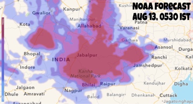
The cyclonic circulation over northern Madhya Pradesh will peter out by tomorrow night but not before it floods areas of the state north of Jabalpur.

Another low pressure area is going to move in soon into West Bengal from the Bay of Bengal by tomorrow. This system will bring heavy rains to West Bengal, Bihar, eastern Uttar Pradesh in the coming 3-4 days.

Meanwhile, a South China Sea tropical cyclone will reach India after weakening into a low pressure area on August 21 after traversing Vietnam, China, Laos, and Myanmar. This system will have great stamina and may reach western Madhya Pradesh by August 24.

So we see it is going to be a very wet eastern India in the coming 7 days as it is hammered by 2 rain systems, one after another.

Flooding rainfall in area between Jabalpur and Kanpur till Wednesday evening. Parts of northern Madhya Pradesh and eastern Uttar Pradesh to be worst affected.

Worst affected districts in Madhya Pradesh will be Khajuraho, Satna, Katni, Damoh.

RELATED: NOAA Forecast Maps


Heavy rains in Uttar Pradesh as the Bay of Bengal low pressure system moving into West Bengal.


Share this PostPin ThisShare on TumblrShare on Google PlusEmail This

AUGUST 12, 2016: Weather Forecast Update: Chattisgarh, Madhya Pradesh Stare At Floods

AUGUST 12, 2016, FRIDAY

After Gujarat, Rajasthan and West Bengal the monsoon focus is on Chattisgarh. Then Madhya Pradesh faces incredibly a week of continuous rain till August 18. Meanwhile as the Rajasthan cyclonic circulation is in its death throes, rains over Delhi, Haryana will lessen, then stop.

The circulation that was formerly a low pressure area over West Bengal lies over Bihar-Jharkhand. This system will move to Chattisgarh and then hover over northeast Madhya Pradesh causing dangerous flooding precipitation in parts of the state for a week. Another low pressure area which will creep in from the Bay of Bengal on August 15-16 will add to the state's misery.

Forecast models are also hinting at the possibility of a cyclonic circulation forming over western Madhya Pradesh-southern Rajasthan on August 20-21, hence bringing another spell of rains to Rajasthan, Gujarat and possibly Sindh.

The GFS model begs to differ. It predicts a Bay of Bengal low pressure area forming on August 20-21 , moving through Andhra, Telangana onto Maharashtra, Gujarat on August 23. It expects another Bay of Bengal low hitting Gujarat on August 28-29. But one should be sceptical as GFS forecasts change rapidly at times.

Very heavy rains in northern Chattisgarh (Ambikapuram, Surajpur) northeastern Madhya Pradesh (Singrauli, Rewa) till Saturday morning.

Heavy rains in northeast Madhya Pradesh (Katni, Jabalpur) on Saturday. Rains will spread to other parts of the state (Omkareshwar, Itarsi) on Sunday.

HEAVY FLOODING RAINS IN EASTERN MADHYA PRADESH ( Jabalpur, Damoh, Katni belt) TILL AUGUST 19, 2016.


Rain radar India August 12
This rain radar image taken at 0630 hours IST shows the cyclonic circulation bringing heavy rains to Chattisgarh, northeastern Madhya Pradesh and parts of eastern Uttar Pradesh.

NOAA FORECAST MAPS


Share this PostPin ThisShare on TumblrShare on Google PlusEmail This

NOAA 24 Hours Forecast Maps: August 11, 2016


AREAS OF FOCUS

SOUTH ASIA

NOAA forecast rain India August 11

DELHI


JHARKHAND 


Share this PostPin ThisShare on TumblrShare on Google PlusEmail This

August 8, 2016: NOAA GFS Rain Forecast Maps, India


August 8, 2016, Monday: The focus of attention is southern Rajasthan. The low pressure area will bring heavy rains to region and adjoining north Gujarat, Kutch in the coming days.


MICRO-LEVEL RAIN FORECAST FOR RAJASTHAN 


RAIN FORECAST TILL TUESDAY MIDNIGHT 


Share this PostPin ThisShare on TumblrShare on Google PlusEmail This

NOAA RAIN FORECAST MAPS, INDIA, AUGUST 6, 2016


There are chances of light rainfall in UAE, Oman today afternoon.


Share this PostPin ThisShare on TumblrShare on Google PlusEmail This

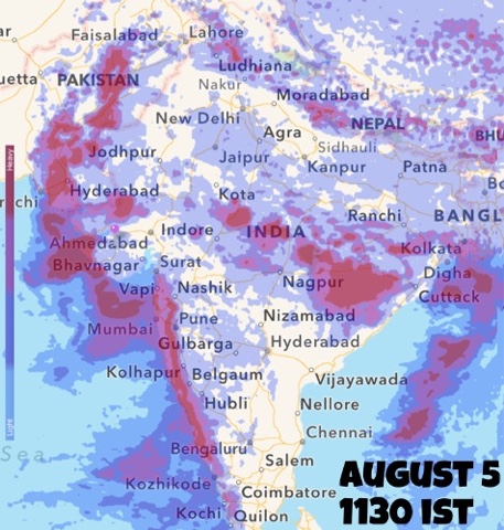
August 5, 2016: 24 Hours GFS Rain Forecast Maps


Share this PostPin ThisShare on TumblrShare on Google PlusEmail This

Rain Forecast Maps (August 2-August 3)

Share this PostPin ThisShare on TumblrShare on Google PlusEmail This

Cyclone NILOFAR: How Will It Affect India and Pakistan?


Latest Infra-Red Satellite Image of Cyclone Nilofar : 1200 HRS GMT, October 29, 2014


The lady is in the Arabian Sea throwing out winds howling at 200-230 Kph. Cyclone Nilofar is slowly inching towards land. The lands affected will be India and Pakistan.

---------------------
LATEST UPDATE: The cyclone will start weakening from tomorrow (Thursday)
----------------------

The winds will be worst at the Kachchh and Sindh coast. The IMD says they will be 80-100 Kph. That is much better than 200 Kph. Look what Hudhud did to Vizag.

The winds will start from Thursday afternoon and continue till Saturday. Worst will be on Friday. Karachi is in for a battering with 100 Kph winds. Dwarka and Kachchh districts will get off with 60-80 Kph winds. But northern Kachchh (Koteshwar) will get a 100 Kph hammering.

The ports of Okha, Jamnagar (Bedi and Sikka), Navlakhi, Kandla, Mundra, Kandla will feel winds of 50-70 Kph on Friday

 Nilofar is going to bring rains. The heaviest will be in Sindh (Karachi included). Kachchh will get off with slightly less rain. Vagaries of nature!

Heaviest rains are expected in Sindh (SE parts, Karachi included). Flooding may occur.

In India rains are expected in Kachchh, west and north Rajasthan (heaviest around Bikaner and Jaisalmer). Showers expected even in Jaipur, Haryana and Delhi on November 1-2, 2014.

Rain Forecast Map: Cyclone Nilofar: From now till November 2, 2014


Total rainfall from Cyclone Nilofar: Where and how much?


Share this PostPin ThisShare on TumblrShare on Google PlusEmail This

Latest Forecasts/Updates


Popular Posts

Search This Site