Showing posts with label August. Show all posts

Good Rains In Andhra, Delhi Today

AUGUST 28, 2016, SUNDAY
 
The circulation over Sindh has brought good rains to the province and western Kutch in Gujarat. This will now move to western Rajasthan and then swing into northern Pakistan in the coming 3-4 days. The cyclonic circulation in the Bay of Bengal will bring heavy showers to coastal Andhra and Telangana in the coming 36 hours. This system will move north through Odisha, Jharkhand, Bihar onto Uttar Pradesh in the coming days bringing increased precipitation in these regions.
Heavy showers in Andhra Pradesh, Telangana till Monday night.
 
Heavy showers in northern Rajasthan which will spread to Delhi, Haryana, Punjab by Monday morning.
 
Showers in Gujarat till today evening.
 
A heavy shower in Diu early Monday morning. 1-2 inches expected.
 
Monsoon rainfall forecast August 28 Sunday Andhra Rajasthan Delhi India
Raining in Chennai, Sindh, Bangladesh and northern Rajasthan 
 
Share this PostPin ThisShare on TumblrShare on Google PlusEmail This

Typhoon LIONROCK Japan Rendezvous OnWednesday

Typhoon LIONROCK August 27 north west Pacific Ocean

AUGUST 27, 2016, SATURDAY 

Latest forecasts hint that the presently category 3 typhoon LIONROCK in north west Pacific Ocean may make landfall into Japan on August 31, Wednesday instead of Tuesday as earlier expected. The target area is northern part of Honshu island, between Iwaki and Shiroishi. The storm may pass perilously close to Fukushima. Tokyo seems to be saved from a direct hit. The typhoon will make landfall about 150 kilometres north of the city. 

At 0000 hours GMT today the cyclone lay about 525 kilometres roughly east of Naha, Okinawa. Direction is north east. Current sustained wind speed is 180 km/h, gusts upto 210 km/h. It was moving at about 9.2 km/h.   It will slowly weaken as it curves towards Japan. 

The JTWC believes it will be a mere tropical storm at the time of impact with 100 km/h winds. It also foresees a landfall at a spot even further north into Honshu (near Morioka and Kitikami) than what we predict. Our estimate is LIONROCK will pack quite a punch at landfall with winds of about 150 km/h.    
Share this PostPin ThisShare on TumblrShare on Google PlusEmail This

Category 3 Typhoon LIONROCK May Hit Tokyo, Central Japan August 30, 2016

Typhoon LIONROCK west Pacific Ocean Japan August 2016

AUGUST 25, 2016, THURSDAY 

Intensifying typhoon LIONROCK is hovering in north west Pacific Ocean presently just a few hundred kilometres from Okinawa. 

Unlike most west Pacific Ocean tropical cyclones this one did not emerge from lower latitudes in the sea east of Philippines but came from North Pacific.

Forecast models seem divided as to where the storm will go. 

In the next couple of days it will retract its steps and strengthen further. Our estimate is by Saturday-Sunday it will be a category 4 hurricane with sustained winds of 240 km/h.

It will then weaken a little and slam into central Japan near Tokyo on Tuesday, August 30, 2016 with winds in excess of 200 km/h.

Worrisome for people of Japan.

0000 hours GMT, August 25, 2016

POSITION: About 900 kilometres roughly east of Taipei 

WIND SPEED:  Sustained- 200 km/h, Gusts- 240 km/h
Share this PostPin ThisShare on TumblrShare on Google PlusEmail This

Super Typhoon LIONROCK May Hit Japan On August 29, 2016

AUGUST 23, 2016, TUESDAY

Tropical storm LIONROCK has already formed. At present it lies about 650 kilometres northeast of Naha, Okinawa in Northwest Pacific Ocean. It already has sustained winds of over 100 km/h. In the coming days it will move a little in the direction of Taiwan then abruptly backtrack.

By Friday it will intensified into a powerful storm. Forecast models indicate the by Sunday it will have a central minimum pressure of an astounding 915 hPa. According to research by American meteorologists with such low pressure in its eye, the tropical cyclone will be throwing winds of about 130-140 knots. That is a category 5 hurricane.

The worrisome aspect is reliable numerical forecast models say super typhoon LIONROCK may hit either southern or central Japan on August 29, 2016. If this does happen it may cause considerable destruction in the country.

The little blessing is the storm is expected to weaken before landfall into Japan.

Tropical storm LIONROCK west Pacific Ocean August 2016
Share this PostPin ThisShare on TumblrShare on Google PlusEmail This

Two Storms In West Pacific Soon? CHANTHU, DIAMMU Coming?

AUGUST 10, 2016


Forecast models are giving confusing signals of the possibility of two or three tropical cyclones to form in the west Pacific, South China Sea area in the coming days. Alarming times for Philippines, Vietnam, China, Japan, Korea, Taiwan.

We had predicted the possibility of typhoon CHANTHU forming in the coming days in the South China Sea and causing a hazard to China.

Well it seems, two tropical cyclones are likely in the region, not one. First CHANTHU, then DIAMMU.

Tropical storm CHANTHU may form first in the Gulf of Tonkin soon. It is likely to intensify rapidly and hit the Haiphong coast of Vietnam on August 15.

Tropical cyclone DIAMMU will form on August 15 in the South China Sea off the Philippines coast. It is expected to turn into a typhoon and hit the coast of Guangdong, China in the Hong Kong-Macau belt around August 18, 2016.

The situation is nebulous at present. Different forecast models are saying different things. For instance, the GFS forecast model predicts a powerful typhoon affecting Philippines, Taiwan around August 20.

Things will become clearer in the coming days.

UPDATE: AUGUST 11, 2016

Something is going to come up soon in the Gulf of Tonkin off the Vietnam coast. A low pressure area is likely to be spawned on August 14, which in a few days might intensify into a tropical cyclone by August 18-19.

There is also a possibility of a strong typhoon hitting Taiwan on August 20, 2016. This may form many hundreds of kilometres north of Guam on August 16.
Share this PostPin ThisShare on TumblrShare on Google PlusEmail This

Another Typhoon Threatens China, Hong Kong-Macau On August 18, 2016


AUGUST 9, 2016

After the powerful NIDA, another typhoon (will be named CHANTHU) poses a threat to Guangdong province of China, in the same Hong Kong-Macau area on August 18, 2016.

Reliable forecast models have been warning of a tropical cyclone formation in the South China Sea since a couple of days. The expected system will be engendered either north or west of Luzon, Philippines on August 14, 2016. Within days it will intensify into powerful typhoon CHANTHU and affect Guangdong, Guangxi, Yunnan, Hainan provinces of China. Perhaps even northern Vietnam if initial data from forecast models is to be believed.

Where will the storm go? How strong will it be? This will become clearer in a few days.

RELATED: Typhoons CHANTHU, DIAMMU Imminent?
Share this PostPin ThisShare on TumblrShare on Google PlusEmail This

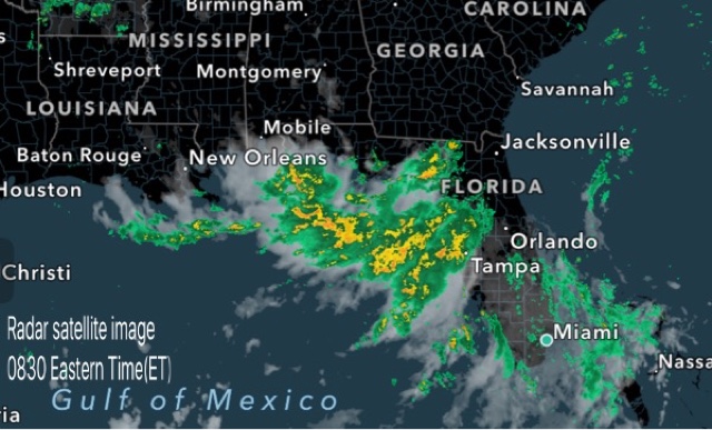
August 8, 2016: United States Extreme Weather Forecast Update

LAUGUST 8, 2015, MONDAY, 0730 ET

The low pressure area with clusters of thunderstorms lies near the Florida coast in the Gulf of Mexico. It will bring heavy rains to northern coastal areas of the state till Thursday after which the system will move along the coast to Louisiana and then by Monday next, August 15, will move inland into Mississippi, Tennessee, Arkansas and Kentucky bringing heavy precipitation.

Heavy rains in coastal areas near Gainesville, Tallahassee, Lake City till Monday midnight. Continuous, intermittent rain expected in these areas till Friday.

Flooding rains in New Orleans, Baton Rouge, Gulfport on Saturday.

Very heavy rains in Louisiana, Arkansas, Tennessee, Kentucky on August 14,15


Share this PostPin ThisShare on TumblrShare on Google PlusEmail This

FLASH UPDATE: DELUGE IN GUJARAT SOON?

AUGUST 5, 2016, 1100 IST 

Earlier forecast models had been saying the Bay of Bengal low pressure system that is currently moving over Odisha, Chattisgarh would go to Rajasthan via Madhya Pradesh onto flood Delhi Haryana on around August 8, 9.

But latest forecast data from NOAA's GFS model says the system will not go to Rajasthan, Delhi but move to Gujarat.

If this happens a deluge awaits Gujarat from August 7, 2016. 

The GFS predicts very heavy rains in south, central, north Gujarat, Kutch and finally in coastal Sindh in the coming 3-4 days.

We are monitoring the situation and will constantly analyse data to see if this GFS prediction stays unchanged and is confirmed by other forecast models

We will provide constant updates.

UPDATE:AUGUST 5, 2016, 1230 IST 

The other reliable forecast models still insist the system will go to Rajasthan. Who is right? The next 24 hours will tell. We tend to agree with the other models. Let us see.

UPDATE:AUGUST 5, 2016, 1700 IST 

The GFS model in its latest data issued today at 0600 hours GMT still stays firm on its prediction. It says the flooding rain system will hit Central, South Gujarat on Sunday noon Indian Standard Time. One shudders to think of Valsad which is still reeling from flooding, if this monster rain system hits it on August 7.

UPDATE:AUGUST 6, 2016, 0730 IST 

Thankfully for Gujarat, it is now almost certain that the Bay of Bengal system will go towards Rajasthan via Madhya Pradesh. 

UPDATE: AUGUST 6, 2016, 1800 IST 

The GFS in its latest forecast issued today at 0600 hours GMT, says the rainmaker system over Madhya Pradesh presently will move to southern Rajasthan and then slink into north Gujarat area around Tuesday, August 9, and bring heavy rains there. Personally we think it is improbable. The GFS model is prone to make inaccurate forecasts at times.


Parts of Gujarat, especially South Gujarat, and parts of Saurashtra are still reeling from flooding rains from an upper air cyclonic circulation. Meanwhile another system from the Bay of Bengal is moving west. GFS model thinks it will hit Gujarat in 48 hours. The next 24 hours will tell if the nightmare situation will realise or not.


Share this PostPin ThisShare on TumblrShare on Google PlusEmail This

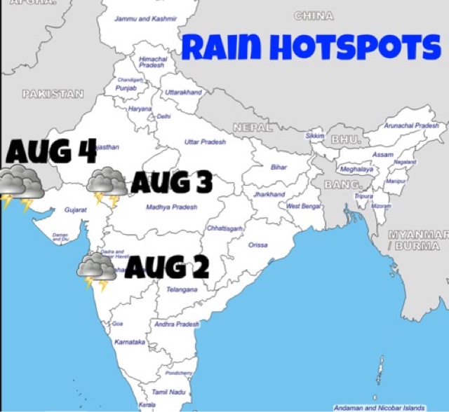
Rain Forecast Maps (August 2-August 3)

Share this PostPin ThisShare on TumblrShare on Google PlusEmail This

Update 5: Typhoon NIDA Makes Landfall Near Hong Kong

AUGUST 2, 2016

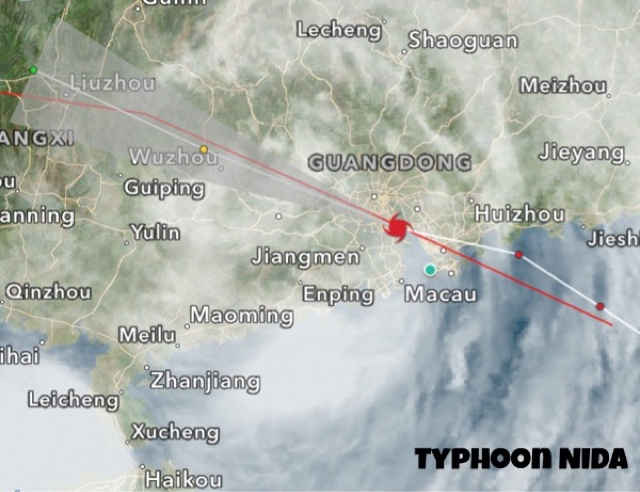
Typhoon NIDA made landfall into China 30 kilometres east of Hong Kong before midnight August 1, 2016 GMT time. Winds at impact were 120 km/h, gusts 150 km/h.

At present it is moving inland into Guangdong province. Though it is weakening, it is still throwing winds of 75 km/h. In the coming couple of days it will weaken further into a low pressure area and bring heavy rains in the province.

Typhoon NIDA landfall China Hong Kong August 2016


Share this PostPin ThisShare on TumblrShare on Google PlusEmail This

August 2, 2016: Monsoon Forecast Update

AUGUST 2, 2016, TUESDAY 

A low pressure system has formed in the Bay of Bengal. It will bring heavy rains to Odisha, Andhra Pradesh, Telangana, Chattisgarh, Madhya Pradesh. It will move onto Rajasthan on August 8.

Another low pressure system will form in the Bay of Bengal on August 9. Where it goes remains to be seen.

The upper air cyclonic circulation that is hovering over southeast Rajasthan will move to southern Sindh by August 4. The system will bring good rains to coastal Sindh on August 4, some districts of Saurashtra (Jamnagar, Dwarka, Porbandar, Kutch) on August 5, 6. There might be some showers in parts of North Gujarat and Kutch in the next 36 hours.

Intermittent heavy rains in Madhya Pradesh in next 5 days.

Heavy showers eastern Maharashtra (Beed, Yavatmal), Chattisgarh (Bhilai, Bilaspur), Telangana (Karimnagar, Warangal) till August 4 morning.

Heavy rains in Rajasthan, Kota-Udaipur area till morning of August 4.

Very heavy rains near Mumbai, Palghar, Ahmednagar, Thane, Nashik districts till Wednesday morning. Floods expected.

Some showers in parts of North Gujarat till tomorrow morning. Banaskantha, Sabarkantha, Mehsana and Patan districts.

Isolated heavy rain in Kutch district of Gujarat on August 6

Heavy rains in coastal Sindh, Karachi on August 4, Thursday.

Heavy showers in parts of Saurashtra on August 5-6, Friday, Saturday. Especially Dwarka, Jamnagar, Porbandar districts.

RELATED: RAIN FORECAST MAPS


1230 IST, August 2: Raining heavily near Mumbai as we had predicted. Rains are tapering off in south Gujarat. Soon heavy rains in Rajasthan in Udaipur-Kota area. The rains will move to southern Sindh, including Karachi on Thursday.


Presently raining near Mumbai, South Gujarat, pockets of Madhya Pradesh and Telangana, Chattisgarh.

Share this PostPin ThisShare on TumblrShare on Google PlusEmail This

Typhoon NIDA Update 4: Heading To Hong Kong, Macau

AUGUST 1, 2016, 1300 GMT

Typhoon NIDA was about 175 kilometres southeast of Hong Kong at 1300 hours GMT, August 1.

Typhoon NIDA rain radar 2016


AUGUST  1, 2016, 0530 GMT

After leaving Philippines, typhoon NIDA has intensified further as it barrels through the South China Sea heading to Hong Kong.

Presently, that is at 0530 hours GMT, the storm is roughly 300 kilometres east of Hong Kong. Sustained winds of 130 km/h, gusts 160 km/h.

Landfall is expected into China, Guangdong province coast 40 kilometres north of Hong Kong at 0000 hours GMT, August 2, 2016, that is after roughly 36 hours.

Wind expected at impact: 130 km/h, gust 160 km/h.

Typhoon NIDA August 1 satellite image


The radar image shows rains have already started in Guangdong as typhoon NIDA approaches.


Share this PostPin ThisShare on TumblrShare on Google PlusEmail This

Latest Forecasts/Updates


Popular Posts

Search This Site