Showing posts with label CHANTHU. Show all posts

Two Storms In West Pacific Soon? CHANTHU, DIAMMU Coming?

AUGUST 10, 2016


Forecast models are giving confusing signals of the possibility of two or three tropical cyclones to form in the west Pacific, South China Sea area in the coming days. Alarming times for Philippines, Vietnam, China, Japan, Korea, Taiwan.

We had predicted the possibility of typhoon CHANTHU forming in the coming days in the South China Sea and causing a hazard to China.

Well it seems, two tropical cyclones are likely in the region, not one. First CHANTHU, then DIAMMU.

Tropical storm CHANTHU may form first in the Gulf of Tonkin soon. It is likely to intensify rapidly and hit the Haiphong coast of Vietnam on August 15.

Tropical cyclone DIAMMU will form on August 15 in the South China Sea off the Philippines coast. It is expected to turn into a typhoon and hit the coast of Guangdong, China in the Hong Kong-Macau belt around August 18, 2016.

The situation is nebulous at present. Different forecast models are saying different things. For instance, the GFS forecast model predicts a powerful typhoon affecting Philippines, Taiwan around August 20.

Things will become clearer in the coming days.

UPDATE: AUGUST 11, 2016

Something is going to come up soon in the Gulf of Tonkin off the Vietnam coast. A low pressure area is likely to be spawned on August 14, which in a few days might intensify into a tropical cyclone by August 18-19.

There is also a possibility of a strong typhoon hitting Taiwan on August 20, 2016. This may form many hundreds of kilometres north of Guam on August 16.
Share this PostPin ThisShare on TumblrShare on Google PlusEmail This

Another Typhoon Threatens China, Hong Kong-Macau On August 18, 2016


AUGUST 9, 2016

After the powerful NIDA, another typhoon (will be named CHANTHU) poses a threat to Guangdong province of China, in the same Hong Kong-Macau area on August 18, 2016.

Reliable forecast models have been warning of a tropical cyclone formation in the South China Sea since a couple of days. The expected system will be engendered either north or west of Luzon, Philippines on August 14, 2016. Within days it will intensify into powerful typhoon CHANTHU and affect Guangdong, Guangxi, Yunnan, Hainan provinces of China. Perhaps even northern Vietnam if initial data from forecast models is to be believed.

Where will the storm go? How strong will it be? This will become clearer in a few days.

RELATED: Typhoons CHANTHU, DIAMMU Imminent?
Share this PostPin ThisShare on TumblrShare on Google PlusEmail This

Weather Forecast Update: Wet Rajasthan Ahead, Low Heads For Bengal

AUGUST 9, 2016, TUESDAY

The cyclonic circulation over southern Rajasthan will flare up for 24 hours bringing very heavy rains over the region. It will move away from the adjoining north Gujarat, hence rainfall activity there will gradually cease.

Under the influence of this system heavy rains will continue in entire Rajasthan till August 12, Friday.

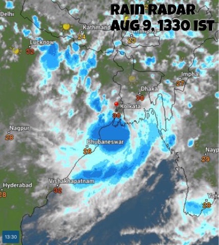
The storm system hovering off the coast of  West Bengal will bring moderate to heavy rainfall in Bangladesh, West Bengal, Jharkhand, Bihar, Meghalaya and Tripura in the coming days.

Meanwhile another Bay of Bengal low pressure area will form August 15. As a result monsoon activity will dramatically increase in eastern India, in Odisha, West Bengal, Jharkhand, Bihar, Chattisgarh.

Forecast models are hinting at the formation of a big typhoon on August 13, 2016, in west Pacific Ocean. The tropical cyclone, which will probably be named CHANTHU, will be formed north of the Luzon coast, in Philippines and may go onto hit the Chinese province of Guangdong at Hong Kong-Macau on August 17-18, 2016. Let us see how things develop.

Very heavy rains in southern Rajasthan (Abu, Sirohi, Rajsamand, Chittorgarh) till Wednesday morning. Rains will move to Jodhpur by Wednesday noon, to Nagaur, Bikaner by Wednesday evening.

Moderate to heavy rainfall to continue in central, northern Rajasthan (Ajmer, Jaipur) till Friday, August 12, 2016.

Very heavy rains in West Bengal, Bangladesh, Tripura, Meghalaya in next 48 hours, till Thursday morning.

Heavy rains in Jharkhand (Ranchi, Jamshedpur) on Friday-Saturday.

Heavy showers in parts of Gujarat:  Bhavnagar, Palanpur, Deesa, Bharuch, Ankleshwar today evening.

RELATED: NOAA Forecast Maps, August 9, 2016

The currently existing rain systems/cyclonic circulations over India. One over NW Madhya Pradesh-Rajasthan, one in Arabian Sea off Saurashtra coast and the newly formed low off West Bengal.


The cyclonic system over Rajasthan will bring rains to the state till Friday 

The low pressure system off the Odisha-West Bengal coast is drenching coastal Odisha and West Bengal.

Share this PostPin ThisShare on TumblrShare on Google PlusEmail This

Latest Forecasts/Updates


Popular Posts

Search This Site