Showing posts with label August 9. Show all posts
Showing posts with label August 9. Show all posts


Weather Forecast Update: Wet Rajasthan Ahead, Low Heads For Bengal
AUGUST 9, 2016, TUESDAY
 The currently existing rain systems/cyclonic circulations over India. One over NW Madhya Pradesh-Rajasthan, one in Arabian Sea off Saurashtra coast and the newly formed low off West Bengal.
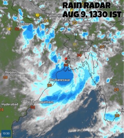


 The low pressure system off the Odisha-West Bengal coast is drenching coastal Odisha and West Bengal.
The cyclonic circulation over southern Rajasthan will flare up for 24 hours bringing very heavy rains over the region. It will move away from the adjoining north Gujarat, hence rainfall activity there will gradually cease.
Under the influence of this system heavy rains will continue in entire Rajasthan till August 12, Friday.
The storm system hovering off the coast of West Bengal will bring moderate to heavy rainfall in Bangladesh, West Bengal, Jharkhand, Bihar, Meghalaya and Tripura in the coming days.
Meanwhile another Bay of Bengal low pressure area will form August 15. As a result monsoon activity will dramatically increase in eastern India, in Odisha, West Bengal, Jharkhand, Bihar, Chattisgarh.
Forecast models are hinting at the formation of a big typhoon on August 13, 2016, in west Pacific Ocean. The tropical cyclone, which will probably be named CHANTHU, will be formed north of the Luzon coast, in Philippines and may go onto hit the Chinese province of Guangdong at Hong Kong-Macau on August 17-18, 2016. Let us see how things develop.
Very heavy rains in southern Rajasthan (Abu, Sirohi, Rajsamand, Chittorgarh) till Wednesday morning. Rains will move to Jodhpur by Wednesday noon, to Nagaur, Bikaner by Wednesday evening.
Moderate to heavy rainfall to continue in central, northern Rajasthan (Ajmer, Jaipur) till Friday, August 12, 2016.
Very heavy rains in West Bengal, Bangladesh, Tripura, Meghalaya in next 48 hours, till Thursday morning.
Heavy rains in Jharkhand (Ranchi, Jamshedpur) on Friday-Saturday.
Heavy showers in parts of Gujarat: Bhavnagar, Palanpur, Deesa, Bharuch, Ankleshwar today evening.
RELATED: NOAA Forecast Maps, August 9, 2016
RELATED: NOAA Forecast Maps, August 9, 2016
The cyclonic system over Rajasthan will bring rains to the state till Friday


Subscribe to:
Posts (Atom)
Popular Posts
-
 JUNE 18, 2016 A major rejuvenation of the monsoon in India will occur only on June 23-24. That is when it will push into Mumbai p...
 -
 JULY 14, 2016 The unpredictability of monsoons was glaringly evident once again as all forecast models had predicted that the upper air...
 -
 JUNE 27, 2016 Progress of monsoon into Gujarat has been sluggish. It has covered half the state and stopped. This is because a big...
 -
 JULY 18, 2016 As predicted monsoon has brought flooding rains to northern India in the last few days. Another smaller system will bring good...
 -
 JULY 23, 2016 The southwest monsoon in South Asia in 2016 has been weird. Though it has dumped satisfactory amounts of rainfall in al...
 -
 The latest lightning and thunderstorms detector satellite image taken at 8:10 AM, IST today, Monday shows a cluster of powerful thunderstorm...
 -
 The image was taken on October 31, 2012 at 0805 UTC. Some time before NILAM made landfall. CLICK TO SEE LARGER IMAGE CLICK TO SE...
 -
 Cyclone Nilofar will subside before making landfall. The westerly winds will sound the death knell of Cyclone Nilofar. Presently it is...
 -
 Weather update South Asia: June 22, 2015. The low pressure area in the Arabian Sea has organised into a depression. At 0000 hours GMT it...
 -
 UPDATE, JULY 20, 6:00PM IST The low pressure system presently over central Madhya Pradesh will move over north Gujarat by Saturday morning....