Showing posts with label Rajasthan. Show all posts

Weather Forecast Update: Wet Rajasthan Ahead, Low Heads For Bengal

AUGUST 9, 2016, TUESDAY

The cyclonic circulation over southern Rajasthan will flare up for 24 hours bringing very heavy rains over the region. It will move away from the adjoining north Gujarat, hence rainfall activity there will gradually cease.

Under the influence of this system heavy rains will continue in entire Rajasthan till August 12, Friday.

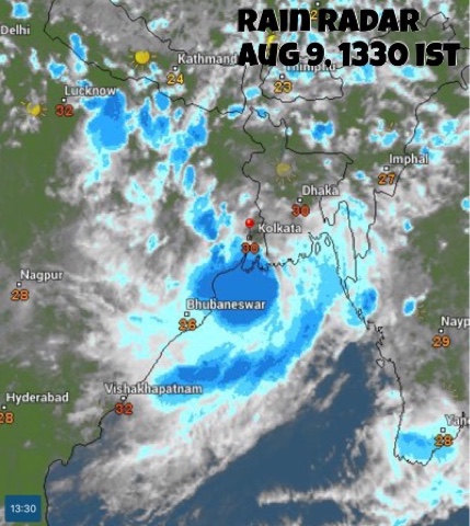
The storm system hovering off the coast of  West Bengal will bring moderate to heavy rainfall in Bangladesh, West Bengal, Jharkhand, Bihar, Meghalaya and Tripura in the coming days.

Meanwhile another Bay of Bengal low pressure area will form August 15. As a result monsoon activity will dramatically increase in eastern India, in Odisha, West Bengal, Jharkhand, Bihar, Chattisgarh.

Forecast models are hinting at the formation of a big typhoon on August 13, 2016, in west Pacific Ocean. The tropical cyclone, which will probably be named CHANTHU, will be formed north of the Luzon coast, in Philippines and may go onto hit the Chinese province of Guangdong at Hong Kong-Macau on August 17-18, 2016. Let us see how things develop.

Very heavy rains in southern Rajasthan (Abu, Sirohi, Rajsamand, Chittorgarh) till Wednesday morning. Rains will move to Jodhpur by Wednesday noon, to Nagaur, Bikaner by Wednesday evening.

Moderate to heavy rainfall to continue in central, northern Rajasthan (Ajmer, Jaipur) till Friday, August 12, 2016.

Very heavy rains in West Bengal, Bangladesh, Tripura, Meghalaya in next 48 hours, till Thursday morning.

Heavy rains in Jharkhand (Ranchi, Jamshedpur) on Friday-Saturday.

Heavy showers in parts of Gujarat:  Bhavnagar, Palanpur, Deesa, Bharuch, Ankleshwar today evening.

RELATED: NOAA Forecast Maps, August 9, 2016

The currently existing rain systems/cyclonic circulations over India. One over NW Madhya Pradesh-Rajasthan, one in Arabian Sea off Saurashtra coast and the newly formed low off West Bengal.


The cyclonic system over Rajasthan will bring rains to the state till Friday 

The low pressure system off the Odisha-West Bengal coast is drenching coastal Odisha and West Bengal.

Share this PostPin ThisShare on TumblrShare on Google PlusEmail This

August 8, 2016: NOAA GFS Rain Forecast Maps, India


August 8, 2016, Monday: The focus of attention is southern Rajasthan. The low pressure area will bring heavy rains to region and adjoining north Gujarat, Kutch in the coming days.


MICRO-LEVEL RAIN FORECAST FOR RAJASTHAN 


RAIN FORECAST TILL TUESDAY MIDNIGHT 


Share this PostPin ThisShare on TumblrShare on Google PlusEmail This

August 8, 2016, Monday: Indian Monsoon Forecast Update

AUGUST 8, 2016, MONDAY

The cyclonic circulation which is presently hovering above southeastern Rajasthan will bring very heavy rainfall to the region and also parts of North Gujarat in the coming 72 hours.

Meanwhile the cyclonic circulation over Sindh has moved into the Arabian Sea. It will dissipate soon.

The Rajasthan rain system will intensify in the coming 24 hours and will die down on Friday, August 12.

The next major monsoon system to be born will be a low pressure area that will develop off the Odisha coast on August 16, 2016.

A smaller cyclonic circulation will form off the West Bengal coast on Tuesday, August 9.  It will move into Bangladesh, weaken and come over to West Bengal.

Heavy showers in Ahmedabad till Tuesday morning.

Very heavy rains in southern Rajasthan (Sirohi, Barmer, Abu, Udaipur, Mandsaur, Chittaurgarh) parts of north Gujarat (Palanpur, Mehsana), by Tuesday, August 9, morning.

Very heavy rains in Pali, Sirohi, Abu, Jhalor (Rajasthan) on Tuesday night.

Medium to heavy rains to continue in southern Rajasthan till Friday, August 12, morning.

Parts of north Gujarat (Palanpur, Patan, Mehsana) to receive medium to heavy rains till Wednesday morning.

Heavy rains in coastal WEST BENGAL, BANGLADESH (Chittagong) till Wednesday morning.


A cyclonic circulation is forming in the Bay of Bengal close to the West Bengal coast. It will move into Bangladesh and then into West Bengal. The system will bring heavy precipitation in these regions in the next 72 hours.

At 0630 hours today morning heavy rains occurring in Rajasthan. The rains will move to parts of north Gujarat and Kutch in the coming 48 hours.

Share this PostPin ThisShare on TumblrShare on Google PlusEmail This

Rains Coming To Rajasthan, Punjab, Kashmir, Himachal Soon

The Bay of Bengal depression that drenched Gujarat for 4 days will weaken and move to Jammu Kashmir and Himachal Pradesh by Wednesday through Rajasthan, Punjab and Delhi.

The depression/low lies over northern Saurashtra presently near Halvad (See Storm Tracker). Under its influence heavy showers are expected in Saurashtra till late evening today. The rains will move to northern Gujarat tomorrow and then into Rajasthan.

By Wednesday (September 23, 2015) the rains will quickly move through the state and then Haryana, Punjab, Delhi and Jammu Kashmir. Heavy rains are possible on Wednesday-Thursday in Jammu Kashmir and Himachal Pradesh.

The following are the GFS rain forecast maps for September 21, 22, 23. The figures are in mm.


Rainfall Forecast till 1200 GMT, September 21, 2015

Rainfall Forecast till 1200 GMT, September 22, 2015

Rainfall Forecast till 1200 GMT, September 23, 2015

Share this PostPin ThisShare on TumblrShare on Google PlusEmail This

Heavy Rains Likely in Western And North India: Forecast Models Differ On Where In Gujarat

The depression that originated in the Bay of Bengal has reached Vidarbha in Maharashtra presently. As a result showers are occurring in western parts of the state.

One thing is sure. In the next 5 days the system will move through Gujarat, Rajasthan, Haryana, Punjab and reach Jammu and Kashmir. It is expected to weaken after leaving Gujarat on September 22, 2015 but the mentioned states will receive good rainfall.

Low pressure area rain track forecast gujarat rajasthan september 2015
The GFS forecast on track and rain forecast of the low pressure area

The confusion lies in where it will rain in Gujarat under the influence of this system. Forecast models differ.

The GFS predicts the depression will weaken from the present 996 Mb system to 1002-4 system in a day or two. A mere low or an upper air cyclonic system. It says only south, central and parts of north Gujarat will get any significant precipitation. Saurashtra-Kutch will be left mainly dry.

The European ECMWF model foresees a stronger system. That the present depression will remain a 994 Mb system as long as it hovers above Gujarat. A stronger system means more rains. It also predicts that the low will move to Kutch and then onto Rajasthan. So this model predicts more rains in Saurashtra and Kutch.

See Detailed Rainfall Forecast Maps

Track The Storm

Satellite image of the low pressure area approaching western India. Image taken at 0530 hours GMT, September 18, 2015

Share this PostPin ThisShare on TumblrShare on Google PlusEmail This

Latest Forecasts/Updates


Popular Posts

Search This Site