Latest Forecast Say Cyclone "Murjan" Will Be Bigger, But Will Hit Burma


Weather prediction map (Click to enlarge) May 26, 2012. The storm nudges the Orissa coast


The projected path of tropical storm Murjan has shifted. (Vagaries of nature). Instead of a weak cyclone hitting the Indian coast at Rajahmundry, it is going to be a big bad boy. And it will just kiss the coasts of Orissa and West Bengal in India and Bangladesh, ( Latest reports say it will not even touch the Indian or Bangladesh coast) but will hit with full fury the Burmese coast on Friday, April 27, 2012.


The stretch most affected will be between the towns of Akyab (Sittwe) and Sandoway on the Burmese coast. Ramree and Cheduba islands are in for a big lashing and heavy drenching from April 27. The whole of Myanmar will get heavy rains on that day. 


The wind speeds when Murjan will hit the Myanmar coast? Excess of 70-80 Kmph. The storm will be spawned on April 23, 2012 east of the Sri Lankan coast. The low pressure area will move north towards the West Bengal-Bangladesh coast for the next 3 days and then intensify strongly becoming a cyclone. It will then curve towards the Burmese coat and hit it on April 27.


Weather prediction map (Click to enlarge): April 27, 2012. The storm curves towards Burma, about to hit it.
Share this PostPin ThisShare on TumblrShare on Google PlusEmail This

"Murjan" Coming? Tropical Storm Brewing in Bay Of Bengal: To Move To Indian Coast In Few Days

WEATHER FORECAST MAP: The storm will hit the Andhra coast on April 25, 2012

The weather gods seem to be in a hurry this year. It is April only and yet a tropical storm is likely to hit the eastern coast of India in the next few days bringing heavy rains and strong winds.

The storm is expected to hit the Indian coast between Visakhapatnam and Rajahmundry on April 25, 2012 (Wednesday) with cyclone strength. The coastal areas of Tamil Nadu and and then Andhra Pradesh will start receiving heavy rains from April 24 itself as the storm starts nearing the Indian land mass. The storm will then move along the coast northwards and strengthen all the time. The heavy winds will really start once it reaches the Visakhapatnam-Rajahmundy belt.


WEATHER FORECAST MAP: High winds and heavy rains on April 25, 2012

The expected storm is germinating in the cloud mass that lies presently about 600 Kms east of the Sri Lankan coast (Latitude: 85 degrees east, Longitude: 6 Degrees north). It will slowly intensify and start moving towards the Indian east coast. It will come  near Puducherry and Chennai which will start getting a drenching from Monday, April 23, 2012 noon (local time).

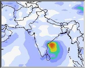
WEATHER FORECAST MAP: Birth of the storm. See the yellow and green mass east of Sri Lanka?

The system will then start moving north. As a result coastal areas of Tamil Nadu and Andhra Pradesh will get heavy rains too. The worst affected will be as said before Guntur-Rajahmundy-Visakhapatanm (April 25). By then the wind speeds will be in excess of 70 Kmph. A cyclone in other words.

The system will move along the coast passing through Orissa (April 26, 2012), Gangetic West Bengal (April 27, 2012) and then Bangladesh (April 27, 2012).

WEATHER FORECAST MAP: Storm hits Orissa. April 26, 2012

The storm is going to reach cyclone strength once it reaches the Rajahmundry area in Andhra Pradesh. That is winds in excess of 64 Kmph. And move with great vigour till it reaches Bangladesh on April 27. After which it will dissipate.

Words of warning. Very strong winds and very heavy rainfall expected from April 25 to April 27. In north coastal Andhra Pradesh, Orissa, Gangetic West Bengal and Bangladesh.

WEATHER FORECAST MAP: It is Gangetic West Bengal and Bangladesh on April 27, 2012

This is going to be a cyclone. A small one albeit. Wonder if the IMD will christen it "Murjan".


Satellite image: April 20, 2012
Share this PostPin ThisShare on TumblrShare on Google PlusEmail This

Latest Forecasts/Updates


Popular Posts

Search This Site