Showing posts with label 2011. Show all posts

Rains To Continue In Oman

The remains of KEILA will bring more rains in southern Oman for the next 2-3 days.

Cyclone Keila has given a lot of rainfall to Oman in the last few days. Now Keila is no more. It is just a low pressure area now near Salalah in southern Oman. But it is going to give heavy rains in the area (Salalah, Raysut, Thamarit, Mudhay and Sadh) in the next 3 days till Sunday (Nov 6, 2011) The system will then move into Yemen and break-up completely and drift northwards bringing rains to UAE and Qatar.


The whole of Oman is expected to receive some precipitation for at least a week. Especially the coastal areas in the Arabian Sea. Then later another little wet spell around Nov 13, 2011 as the remnants of the low pressure area (which is likely to form on Nov 6, 2011 and move to the waters near the coasts of Oman, Pakistan and Gujarat) drift into Oman.


Nov 13, 2011. Remains of the Arabian Sea Low Pressure will drift into Oman and bring it more rains.
Share this PostPin ThisShare on TumblrShare on Google PlusEmail This

Qatar And UAE In For Rains Shortly Thanks To A Dead Keila

Keila is bringing rains to unexpected places. It has drenched Oman in the last few days (And will bring some more rain for a few more days). Now as it starts breaking up, Qatar and UAE are in for some sharp showers. Qatar first. The rains will start by Sunday evening (Nov 6, 2011) and will continue for 24 hours. The heaviest falls will be on Sunday night.


UAE (Abu Dhabi). The rains will start Monday early morning (Nov 7, 2011) and increase gradually. They will taper off by Tuesday night. It is going to be a very wet Monday in Abu Dhabi.


Rain Prediction Maps

 Rains in Qatar (see the white arrow) on Nov6, 2011 Sunday

Rains arrive in UAE and Abu Dhabi on Monday (Nov 7, 2011) night
Share this PostPin ThisShare on TumblrShare on Google PlusEmail This

Latest Forecast Says Nov 6 Arabian Sea Storm To Be A Mere Low Pressure Area


Slightly dampening news. The expected Arabian Sea storm to be formed on Nov 6, 2011 is not going to be full-blooded cyclone (Nor a Depression). It will be a low pressure system.

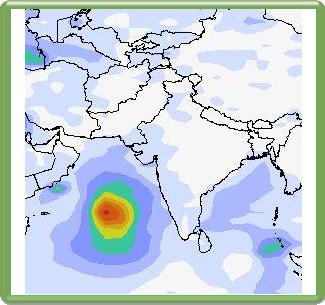
The storm will form as said earlier in the Arabian Sea about 1000 Kms NW of Maldives. It will generally move towards the seas between Oman, Pakistan and Gujarat. It will reach there on Nov 10, 2011.

There will be a lot of rains in the sea and then the system will disintegrate around Nov 11, 2011. Some substantial precipitation in Sindh and Gujarat on Nov 11, 12. The remains will drift to Oman and give it some rainfall on Nov 13, 14, 15.

 Nov 6, 2011. The low pressure system is born

 Nov 8, 2011 The storm system moves north towards the seas near Oman, Pakistan and Gujarat

Nov 10, 2011. The low pressure kisses the Omani coast

 RAIN PREDICTION MAP NOV 11, 2011

Nov 11, 2011. Rainfall forecast map. Look at the amount of rains! The system then starts to fizzle out giving some good rains to Sindh and Gujarat


Share this PostPin ThisShare on TumblrShare on Google PlusEmail This

New Big Depression To Form In Arabian Sea Nov 6, 2011

 Wind speed forecast map. The expected depression will cover a large area. A big storm. Seen at its full power on Nov 9, 2011

While the short lived Keila slinks away to Yemen, a new big storm will take birth in the Arabian Sea on Nov 6, 2011. It will not be of cyclone strength; a depression or may be a deep depression. But the remarkable thing is it is going to be depression covering a large area. A big one in short.

As said earlier it will move to the seas between the Omani and Gujarat coast till November 9, 2011. But then it will start breaking up on the 10th of November.Heavy rainfall will lash Pakistani coast on Nov 11, 2011. Gujarat will too get some rains on Nov 13.  as the remnants of the depression will drift towards the state.
Rain forecast map. Sindh and Balochistan coastal areas are in for flooding on Nov 11, 2011

Rain prediction map. Nov 8, 2011. The depression will throw a lot of rain into the Arabian Sea. The purple color means a deluge
Share this PostPin ThisShare on TumblrShare on Google PlusEmail This

Oman In For Rains Thanks To Little Keila


Now who would have thought it would turn out this way? The storm in the Arabian Sea in June 2011 (Remember it?) traversed from Kerala all the way to the Gujarat coast; took ten days to do that and what happened? It was not even honored with a name (IMD called it 01A)! And this piddly little short-lived storm off the South Oman coast gets the name Keila!

Anyway.

Oman is in for rains for the next 2-3 days due to Keila. The rains will dry up in the rest of Oman after Keila moves away weakened, below storm strength, into Yemen. But not Muscat. Muscat will keep getting showers till at least the 8th of November, 2011.

 Lots of rains presently in Oman and the sea thanks to Keila

In the next two days Omani towns of Sadh, Saladah, Raysut, Mudhay, Thamarit and Marmul are in for a drenching. The rest of the country too will get light to heavy falls in the next 2 days

Oman is likely to get more rains around November 14-15, 2011 owing to new storm that is going to get spawned in the mighty Arabian Sea. But more about that elsewhere.

Track/Path of Keila
Share this PostPin ThisShare on TumblrShare on Google PlusEmail This

No Big Storm? Just A Depression In The Arabian Sea?

The cliche that weather is very unpredictable is certainly true. Just yesterday forecasts said that a big big cyclone would ram the Pakistani coast on the 9th of November, 2011. Now the same forecasts say a storm yes. But not a big one. A depression.


Now even a depression is nothing to sneeze at. They have strong winds. They cause downpours.


A depression is expected to form around the 6th of November, 2011 in the Arabian Sea 1000 Kms NW of Maldives. It is expected to move gradually north-westwards towards the Oman coast for the next 2 days. Once it nears the Omani coast it will gain strength and hover around for a day or two. Then it will start weakening and move North-easterly towards the Pakistan coast. By the 12th or 13th it will slowly fizzle out just off the Pakistani coast.


The result? Rain in Sindh on November 10, 11 and more of it in Gujarat on the 12th and 13th of November. Gujarat will benefit rain wise as the remnants of the depression will drift to it. Oman will hardly get any rain from this depression even though it will kiss the coast.


Still many days to go. Lets keep watching... May be a big storm might come. Or maybe no storm at all! Vagaries of nature.


Wind Speed Prediction Map

 The depression will be strongest on Nov 9, 2011 when near the coast of Oman

Rain Forecast Maps

 Wow! A deluge in the sea! Nov 10, 2011

Nov 12, 2011. The storm breaks and drifts towards Gujarat, bringing rains
Share this PostPin ThisShare on TumblrShare on Google PlusEmail This

Monster Cyclone To Slam Pakistan Coast On November 9, 2011


The Arabian Sea this November is in ferment. While a depression hovers around the south Oman coast and will bring rain to the country for the next 3 days, another storm is likely to be spawned in the sea near the Indian coast off Kerala on 3rd of November. This little system will at first take baby steps in a WNW direction, growing bigger all the time for the next 4 days (till Nov 7, 2011). It will then turn into a big monster and start curving gradually northward and hit the Pakistan coast on November 9, 2011.


Boy! This baby is going to be massive! As it nears the Pakistan landmass its diameter will touch the Omani coast on one side and the Gujarat coast on the other side. Huge! 


Surprisingly this big girl (Keila?) will bring little or no precipitation to Oman and Gujarat but Sindh and Balochistan are in for a big big deluge on November 9, 10. 


And winds? Very strong winds. Destructive would describe it well. Watch out, Pakistan!


Eight more days. Where will Keila (If  I may call her so) go? Pakistan, as predicted now, or will Oman (Or Gujarat ) will face its fury?


Cyclones are very unpredictable.


Keep reading this site for updates.....


Arabian Sea Nov 2011 Cyclone Keila Forecast Maps

 Nov 3, 2011. Keila is born off Kerala coast

 Novemeber 7, 2011. Keila is a big bad girl now

 November 9, 2011. Big Cyclone just hitting the Pakistan coast. The red color shows very strong winds

Rainfall forecast map. Nov 9, 2011. Keila brings a deluge to Pakistan
Share this PostPin ThisShare on TumblrShare on Google PlusEmail This

Muscat In For Three Days Of Rain Till Nov. 3, 2011


The present depression in the Arabian Sea hovering around the coast of Southern Oman is going to bring 3 days of rains to Muscat. Till the 3rd of November. The rest of Oman will get rains too but Muscat in for a special favour by the rain gods. Not heavy falls but rains nevertheless.


The depression is likely to intensify on Nov 4, 2011 but will never turn into a cyclone. It will peter out on Nov 5, 2011.


Prediction for Oman coast depression

 VERIFYING TIME     POSITION     STRENGTH        TENDENCY

  --------------     --------     --------        --------

 00UTC 01.11.2011  15.0N  56.7E     WEAK

 12UTC 01.11.2011  16.5N  56.1E     WEAK     WEAKENING SLIGHTLY

 00UTC 02.11.2011  15.4N  54.9E     WEAK    INTENSIFYING RAPIDLY

 12UTC 02.11.2011  16.1N  54.6E     WEAK        LITTLE CHANGE

 00UTC 03.11.2011  15.4N  54.6E   MODERATE  INTENSIFYING RAPIDLY

 12UTC 03.11.2011  15.4N  54.7E    STRONG   INTENSIFYING SLIGHTLY

 00UTC 04.11.2011  15.3N  54.0E    STRONG   INTENSIFYING SLIGHTLY

 12UTC 04.11.2011  15.4N  53.0E    STRONG       LITTLE CHANGE

 00UTC 05.11.2011  15.4N  51.9E    STRONG       LITTLE CHANGE

 12UTC 05.11.2011     BELOW TROPICAL STORM STRENGTH


WHAT THE INDIAN MET DEPT. SAYS ABOUT THIS DEPRESSION?

ARB 02/2011/06 , Dated: 31.10. 2011
Time of issue: 2000 hours IST


Sub: Depression over westcentral Arabian Sea.


The depression over west central Arabian Sea moved northwestward and lay centred at 1730 hrs IST of today, the 31st October 2011 over westcentral Arabian Sea near latitude 16.00N and longitude 57.50E, about 1900 km west-northwest of Mangalore (Karnataka), 550 km northeast of Socotra Island (Yemen) and 400 km east-southeast of Salalah (Oman). The system is likely to intensify further into a deep depression and move west-northwestwards cross south Oman and adjoining Yemen coast close to south of Salalah around morning of 2nd November 2011


The depression is not expected to cause adverse weather along and off west of coast of India. However, the system is under constant watch for its further development


Rain Forecast Map
Oman is in for some rain. Muscat will get showers till Nov 3, 2011

There is a big storm which will take birth near the Indian coast near the state of Kerala on November 3, 2011. This storm is likely to be a monster and present forecasts say it will hit the Pakistan coast on November 9, 2011. Oman and the Indian state of Gujarat will be spared. But it is early days. Who knows? But more about that in another article....
Share this PostPin ThisShare on TumblrShare on Google PlusEmail This

Bay Of Bengal Depression To Bring Heavy Rains To Tamil Nadu, Andhra November 13, 14 2011

A low pressure system is likely to form in the Bay of Bengal on November 10, 2011 west of Andaman islands. It will then gain strength and turn into a deep depression and move westward in the next three days. It will make landfall on November 13, 2011 at the coast of Tamil Nadu and Andhra Pradesh. Heavy rainfall is likely in these two states on November 13, 14.


Rain Forecast Map

Heavy rains likely on Nov 13, 14 in Tamil Nadu and Andhra Pradesh

Wind Speed Map Nov 13

November 13, 2011. The deep depression will make landfall. Quite strong winds
Share this PostPin ThisShare on TumblrShare on Google PlusEmail This

Arabian Sea (Nov 2011) Deep Depression To Bring Rains To Oman Till November 10

A rather persistent Deep Depression has formed in the Arabian Sea near the coast of Oman. (Folks of Oman must be enjoying the cloudy weather at present!) Now this system is going to stick around the Omani coast for the next eight days or so. Result? Rains in Oman for the next ten days. Not too heavy but substantial. As a result of the system southern Pakistan will get a drenching from November 1- 4, 2011. Especially affected will be area near Gwadar, though Karachi will get some rains too.


Now this Deep depression will gain strength and almost reach cyclone level around Nov 4, 2011. But it is unlikely that it will turn into a big bad cyclone. So windy weather on the coast of Oman till November 7th. And rains too. The coastal areas will receive more precipitation. But Muscat too is going to get wet on November 1-2, 2011. May be later also.


In short, a rare wet spell for Oman in the next 8 days. Enjoy it!


Rainfall Forecast Maps for Oman In November, 2011

 November 1, 2011. Oman gets its first rains. Muscat too.

Nov 6, 2011. More rains in Oman

Rain Forecast Map Southern Pakistan Nov 2011

Southern Pakistan coast gets a deluge. Rains expected here Nov 1-4, 2011

Wind Speed Forecast Map Arabian Sea Depression November 2011

On Nov 4, 2011, the depression will gain strength and almost become a cyclone. But it will not. It will start dissipating and the remnants of the system will drift to Oman and give it more rains on November 6, 7
Share this PostPin ThisShare on TumblrShare on Google PlusEmail This

Tropical Storm To Form In Arabian Sea Near Kerala November 3, 2011

The northern Indian ocean is turbulent this year in Oct.-Nov. A low pressure area will bring heavy rains to south Pakistan on November 2, 2011. A deep depression in the Bay of Bengal will hit coastal Tamil Nadu and Andhra Pradesh November 11, 2011. AND.....!

A tropical storm is likely to form near the Kerala coast on November 3rd, 2011. It will start as a low pressure area and then move northwards. When it nears the Goa coast it will intensify into a cyclone. It will then move north-westerly in the Arabian Sea, hover around and slowly dissipate and drift towards Oman bringing some rains on Nov. 12-14, 2011.

Present Forecasts say it will not touch Gujarat (rains likely in Gujarat under its influence though. Especially on Nov. 7-8, 2011). Nor will it hit Pakistan or Oman. But hard to say for sure. Keep reading this site...
Wind Speed Forecast Maps

 November 5, 2011. The low pressure system near the Goa coast has gained strength and turned into a cyclone
November 3, 2011. The low pressure system is born near Kerala coast. Notice that the earlier system is lashing south Pakistan
Share this PostPin ThisShare on TumblrShare on Google PlusEmail This

STORM JOSE COMING? Depression '10 L' In Atlantic Ocean To Grow Into Big Storm, Touch US East Coast In 10 Days

As the US is bracing to  deal with nasty Irene, reliable forecast models say a depression (called 10 L) has formed in the Atlantic Ocean. It lies at 16 degrees North and 34 degrees West at present. It is moving at a speed of 7 miles per hour in a NNW direction. Most models are confused as to where 10 L is going to go. But we have reliable information that 10 L is going to gather strength and move towards the US eastern coast. It will reach near the coast in about 10 days time. Friday 9th September, 2011. Present forecasts say the expected storm will just skim the US coast and not hug it like Irene has done. But who knows what will happen in 10 days? Keep reading this site. Maybe Tropical Storm Jose is coming.....


FORECAST PATH OF EXPECTED TROPICAL STORM 10 L. FORECAST MAPS


 This is on Wednesday. August 31, 2011. Depression 10 L has gained strength and is moving westwards towards the US coast, growing all the time.

 Friday. September 9, 2011. 10 L has turned into Tropical Storm Jose and is near the US coast

 Sunday. September 11, 2011. Jose moves northwards along the US East Coast but keeps its distance.

Monday. September 12, 2011. Jose moves near the Canadian coast. 
Share this PostPin ThisShare on TumblrShare on Google PlusEmail This

Nasty Storm Irene Will Hit Entire Eastern US Coast; Heavy Rains Likely In US and Quebec Next Two Days

Irene is a nasty lady. The tropical storm in the Atlantic is hammering away at South Carolina at present. And it is going to inch upwards along the American East coast. With strong winds and lots and lots of rain. So folks in South Carolina, North Carolina, Virginia, Pennsylvania, Delaware, Maryland and New York are in for a very wet days. The east coast in short. Irene is then going to walk into Quebec in Canada On Sunday (August 28, 2011) evening (local time). Very heavy rainfall throughout Sunday night in Quebec. The cities of Ottawa, Montreal and Quebec are in for a drenching.


HIGHLIGHTS OF THE FORECAST

  • The states of Richmond and Delaware will start getting heavy precipitation from Saturday morning (local time). So will Richmond in Virginia. These places will get a drenching for twenty four hours.
  • It will start raining heavily in New York City from Saturday (August 27, 2011) afternoon. Very heavy rains in New York city.
  • The states of Vermont and New York will get heavy rains Sunday afternoon.
  • The Canadian cities of Quebec and Montreal will start getting heavy rains from Sunday (August 28, 2011) evening (local time).
  • Now we come to the winds. The coastal areas of the United States will face the brunt of Irene's fury. By east coast I mean uptil Maine. Irene's wind speeds will fall once it goes into Canada's coastal areas. But Nova Scotia and New Brunswick are going to face some very strong winds. 
  • The wind speeds will be lower as we go away from the coast.

This is the position of Irene at 3.00 AM, Saturday morning (local time) August, 2011. Red means very strong winds

Sunday morning. August 28, 2011. Irene hits New York city

Monday morning local time. August 29, 2011. Irene weakens leaves the US caost and moves to the Canadian coast

This is a rainfall forecast map. It shows Irene drenching New York city on Sunday morning.

Rain forecast map. Sunday (August 28, 2011) late evening. The rains due to Irene start in Canada after wetting New York state.
Share this PostPin ThisShare on TumblrShare on Google PlusEmail This

Big Tropical "Ma-On" To Hit Japan In Two Days

Monday July 18, 2011. Ma-On approaches Japan

The big big storm Ma-on stands menacingly 270 miles SSE of the island of Iwo Jima. Latitude 140.6 E. Longitude  20.6 N. The southern island of Iwo Jima will start experiencing the approaching storm from Sunday (July 17, 2011). Ma-On will not pass through Japan. That means, the country will not bear the brunt of strong winds. The storm will approach the Japanese mainland then move along the coast for two-three days then move away eastward, weakening all the time.

HIGHLIGHTS OF TYPHOON MA-ON

  • The coast of south Japan will start experiencing strong winds from Monday (July 18, 2011).
  • Ma-On will touch Iwo-Jima and then creep along the coast for the next two three days
  • Maximum wind speeds will not be felt in Japan proper but in the sea off the country's coast. Speeds may touch 150 kph. Big wind!
  • Even Japan will face strong winds.
  • Mostly affected will be the islands of Kyushu, Shikoku and Honshu. Tokyo is in for winds and rain. More like a deluge I would say. From Monday (July 18, 2011). till Wednesday. Lots and lots of rain.
This is where the storm is now. Friday. July 17, 2011.6.00 Hrs UTC
Share this PostPin ThisShare on TumblrShare on Google PlusEmail This

Tropical Storm Seven-W (07W) Brewing In The Philippine Sea Will Bring Rain To Korea

There is another storm (Seven-W) brewing in the Philippine Sea. It is expected to form anytime. UK's Metoffice says the place of birth is going to be 11.9 N, 131.8 E. Now this tropical storm will not become a monster but will remain a deep depression or a small cyclone. It may even get a name. The important thing is this storm is going to head NNE and go to Korea by the June 25th, 2011. That is what GFS says. NOGAPS says it will bring rains to Korea on the 27th June, 2011. NOGAPS forecasts lesser rain to Korea. GFS says the storm is going to drench Korea. NOGAPS says the storm will move between Korea and Japan. GFS says it is going to walk through Korea.


PREDICTIONS

  • A new tropical storm is to be born in the Philippine Sea anytime now.
  • It is going to move in a northerly direction and head towards Korea.
  • It will bring some rain to Taiwan and Japan but it is going to give lots of rains to Korea around the 25th of June. 
  • Strong winds will lash Korea and Kyushu islands of Japan on June 25, 2011
  • The storm will move further to the Russian coast and disintegrate around the 27 of June, 2011.

 The GFS forecast: The storm will drench Korea on the 25th of June, 2011


The NOGAPS forecast says the storm will creep through Korea and Japan. It will bring rains to southern Japan. June 27. 2011.
Share this PostPin ThisShare on TumblrShare on Google PlusEmail This

Depression In Bay Of Bengal Will Move Westwards To Madhya Pradesh Over The Week


This is what the Indian Met Department says of the depression (deep depression) that has formed in the Bay of Bengal.

Dated: 17.06.2011
Sub: Deep depression over Gangetic West Bengal and adjoining Bangladesh.
The deep depression over Gangetic West Bengal and adjoining Bangladesh remained practically stationary and lay centred over Gangetic West Bengal and adjoining Bangladesh at 0530 hrs IST of today, the 17 June 2011, near lat. 22.50 N and long. 89.00 E, about 130 km northeast of Sagar Island, 80 km east of Kolkata and 150 km west-northwest of Khepupara (Bangladesh). The system is likely to move north-northwestwards initially and then west-northwestwards and weaken gradually into a depression during next 24 hours.
Under its influence, rain/thundershowers at most places with heavy to very heavy falls at a few places would occur over north Orissa, Jharkhand and coastal districts of West Bengal during next 48 hours. Isolated extremely heavy falls (25 cm) would also occur over north Orissa during the same period. Rainfall at most places with isolated heavy to very heavy falls would occur over south Orissa, Chhattisgarh and remaining parts of Gangetic West Bengal during next 48 hours.
Squally winds with speed reaching 45-55 kmph gusting to 65 kmph would occur along and off north Orissa and West Bengal coasts during next 12 hours. Sea condition will be rough to very rough along and off these coasts. Fishermen are advised not to venture into the Sea off these coasts during next 12 hours.
The system is under constant watch and concerned state Govts are being informed accordingly.

This is the first depression/low pressure area that has formed in the Bay of Bengal. One may note that the early low pressure areas in the Bay of Bengal move westward (Towards western states of India). But as the monsoons progress, they start shifting to a north-westerly and a northerly direction (moving towards Uttar Pradesh and Bihar).


This particular storm is going to bring a lot of rainfall to many states in India, starting with Bengal,Orissa, Bihar, Jharkhand, Chattisgadh, Madhya Pradesh, parts of Maharashtra and then some precipitation in Gujarat! A busy guy! But the rain system will reach Gujarat (a very weak system by that time) after a week. It will traverse India east to west in one week.

PREDICTED PATH OF THE LOW PRESSURE AREA


The present.June 17, 2011. Friday. The storm is drenching Orissa, Bengal and parts of Bihar

Saturday (June 18, 2011) evening IST. The storm has moved north-westerly towards Bihar. But it will swing direction again soon and head west for Gujarat

June 19, 2011. Sunday (IST) early morning. The rains have arrived in eastern Madhya Pradesh.

Monday (June 20, 2011) evening.The low-pressure area barrels along Madhya Pradesh

Friday.June 24, 2011. The rain system comes to Gujarat. A long journey!


Share this PostPin ThisShare on TumblrShare on Google PlusEmail This

Latest Forecasts/Updates


Popular Posts

Search This Site