Showing posts with label hurricane. Show all posts

Future Monster Hurricane MATTHEW May Go Anywhere

SEPTEMBER 29, 2016, THURSDAY 

Tropical storm Matthew slowly moving west in the Carribeans has forecast models pointing at different directions when the future track of this soon to be monster hurricane is concerned.

Yesterday we had hinted it could hit Miami, Florida on October 6-7, 2016. This prediction we had based on the ever reliable European model, ECMWF. Today the ECMWF is predicting a different path. It expects a direct hit on Haiti on October 5, 2016. This model further says that this storm is going to be even stronger than earlier expected. After passing Haiti, it will intensify into a category 4 monster reaching a central minimum pressure of 927 hPa. That means winds in excess of 120 knots. Possibly Bermuda is in for a royal thrashing.

But as we said earlier different forecast models are saying different things. The National Hurricane Center says Cuba is for a rendezvous with Matthew. But it remains silent on where the hurricane will go after that. Head for Florida? Or swing away into North Altlantic Ocean?

The present situation is that it could go anywhere, from states adjoining the Gulf of Mexico (seems unlikely) to a hit on Florida (less unlikely) or sailing away into the Atlantic after giving Haiti or Cuba a good hiding.


UPDATE: SEPTEMBER 30, 2016, FRIDAY

Though the official National Hurricane Center forecast predicts hurricane Matthew will move through Cuba and into the Altlantic, the threat to Florida remains. The reliable ECMWF model foresees a hit on the state. Supporting it is the NHC-LBAR model. Even the GDFL and GDFN models predict a path close to Florida.

This storm has many folks in the weather forecasting community on tenterhooks. The red line is the ECMWF prediction. The white line with red dots is the official NHC forecast.


Share this PostPin ThisShare on TumblrShare on Google PlusEmail This

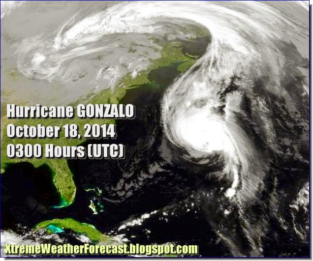
Hurricane GONZALO Is Battering Bermuda Now: May Reach Britain In A Few Days!


This guy may not be as big and powerful as Katrina but he has stamina. Hurricane Gonzalo which is hammering Bermuda now, may even reach the British Isles , according to the NHC!

That means this storm is going to make a trans-Atlantic trip. Very few storms have done that in recorded history.

The guy is pulverising Bermuda with 185 Kph winds. Newfoundland will get a taste of Gonzalo in a day or two with 100+ kph winds. When it reaches Britain on October 21, 2014, it will still pack winds of 60-115 Kph. Phew!

Hurricane Gonzalo reaches Britain on October 21, 2014


Hurricane Gonzalo Hits Bermuda. NBC Video
Share this PostPin ThisShare on TumblrShare on Google PlusEmail This

The Atlantic: Hurricane EDOUARD Will Weaken and peter out in a day or two

Satellite image of Hurricane EDOUARD taken at 0300 Hrs, September 17, 2014

Meanwhile the Atlantic Ocean has been relatively peaceful this year. Unlike other years it is not hurtling monsters like Katrina.

Right now Hurricane Edouard is pottering around in mid-Atlantic. Causing nuisance only to the shipping lanes. But is expected to die down in a day or two.

No new tropical storm are likely in the Atlantic Ocean in the next few days.


The journey of Hurricane Edouard (Courtesy: Hamweather.com)
Share this PostPin ThisShare on TumblrShare on Google PlusEmail This

Tropical Cyclone NANAUK Is Coming After all! To Hit Central Oman On Friday 13, 2014

XWF PREDICTION MAP: Tropical Cyclone NANAUK as forecasted on June 10, 2014 (Tuesday)

Latest forecasts say that Tropical Cyclone NANAUK is coming! We have earlier said that a low pressure area has formed in south Arabian Sea.

This low pressure area is expected to transform into cyclone Nanauk on Sunday (June 8, 2014). The wind speeds will start gusting at above 62 Kmph. This is the threshold which the Indian Met Dept. (IMD) has set for naming a cyclone. So the tropical storm is expected to be christened "Nanauk" on Monday (June 9, 2014).

The present low pressure area will start moving in a NE direction, strengthening all the time. By the time it reaches the Indian coast off Goa on Sunday it will metamorphose into a cyclone.

After that the cyclone is expected to curve away towards Oman in a NE direction. It  will touch the coast of central Oman on June 13, 2014 (Friday). The town which will bear the brunt of the storm is Duqm.

The storm (Nanauk) will weaken slightly before it makes land fall on June 13. But when on its way it is expected that it will throw out very strong winds in excess of 50 Knots (85 Kmph).

The area around Duqm will experience very heavy rainfall.

XWF STORM PREDICTION MAP: The path of Cyclone Nanauk from June 8 (Sunday) to June 12, 2014 (Thursday)
Share this PostPin ThisShare on TumblrShare on Google PlusEmail This

South China Sea To Spawn Tropical Storm "Mitag"/"Ester" On June 13, 2014

EAST ASIA

Path of expected tropical storm Ester (or Mitag) from June 13, 2014 to June 18,2014

The season of tropical storms is upon us. The North Indian Ocean has so far disappointed us. In the Americas, only a piddly little Amanda was formed in the Eastern Pacific near Mexico.

The much vaunted west Pacific typhoon season is perhaps about to begin. SE Asia is infamous for its tropical storms. Last year if I have the facts right,  the Pacific Ocean had been hurtling storms by the handfuls, one after another.

This year the account will open with the South China Sea. A low pressure area is likely to develop here off the Manila coast. On June 13, 2014. This system will slowly move northward turning into a depression. Taiwan is likely to get lots of rainfall on June 14, 2014. The depression will then intensify into a typhoon and turn in a NE direction. It will pass by Japan from below on the 16th of June and then move on to dissipate into the Pacific.

But the Japanese islands of Okinawa and Ryukyu are likely to bear the brunt of Tropical Storm Mitag on June 16, 2014.

June 16, 2014. Heavy rains in the Japanese island of Okinawa.
Share this PostPin ThisShare on TumblrShare on Google PlusEmail This

Hurricane Irene Will Bring Heavy Rains To Eastern Pennsylvania, Vermont, New York State and Quebec In Canada

Forecasted path of Hurricane Irene

Irene is battering Washington DC, Philadelphia, and Baltimore presently. New York will get a drenching till Sunday (August 28, 2011) evening (local time). The state of New York is in for for the heaviest rainfall till early hours of Monday. The heavy rains will then move into Canada, with Montreal, Ottawa and Quebec (city) bearing the brunt of the precipitation. Irene is moving rapidly so the rains in Canada will start from Sunday afternoon. The rain clouds of Irene will travel northwards through the state of Quebec with Labrador city and Newfoundland getting some rains Monday (August 29, 2011) afternoon.


FORECAST HIGHLIGHTS

  • Where will be the strongest winds? New York city because Irene is making landfall there. Also the US states of New Hampshire, Massachusetts, and Maine. The cities? Hartford, Providence, Boston and Augusta. All Sunday night.
  • The winds in Canada? Less than those in the US but still quite strong. Especially in the provinces of New Brunswick and Newfoundland. The towns? Fredericton, Charlottetown and St. Johns. Monday morning.
  • Heaviest rains are forecast in the states of New York, Massachusetts, New Hampshire, Vermont, Connecticut Sunday afternoon. Flooding would be word most apt to use here. Very heavy downpours.
  • Sunday late night the rains move into Canada. Ottawa, Quebec (city) and Montreal are to get the most drenching. The entire Canadian province of Quebec will get rains on Monday.
RAIN FORECAST MAPS: HURRICANE IRENE

SUNDAY AFTERNOON. 3 pm. New York, Connecticut, New Hampshire and Vermont getting heavy rainfall

 Sunday late night. The rains move into Quebec, Canada

Monday (August 29, 2011) early morning. Ottawa, and Montreal get a drenching

WIND MAPS: HURRICANE IRENE

 Sunday (August 28, 2011) late night (EDT). The winds slowly leave New York city and move to Boston, Providence, Concord and Augusta


Monday early morning (EDT).The winds batter the coast of Maine and enter Canada
Share this PostPin ThisShare on TumblrShare on Google PlusEmail This

Latest Forecasts/Updates


Popular Posts

Search This Site