Typhoon GONI: Target South East Korea August 25, Tuesday Late Evening.

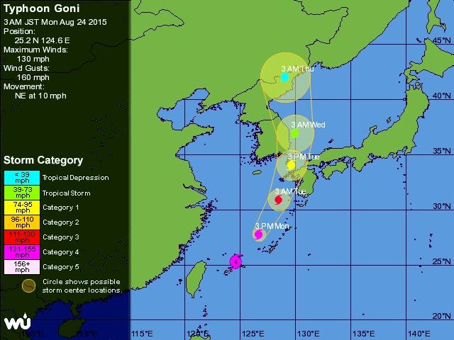
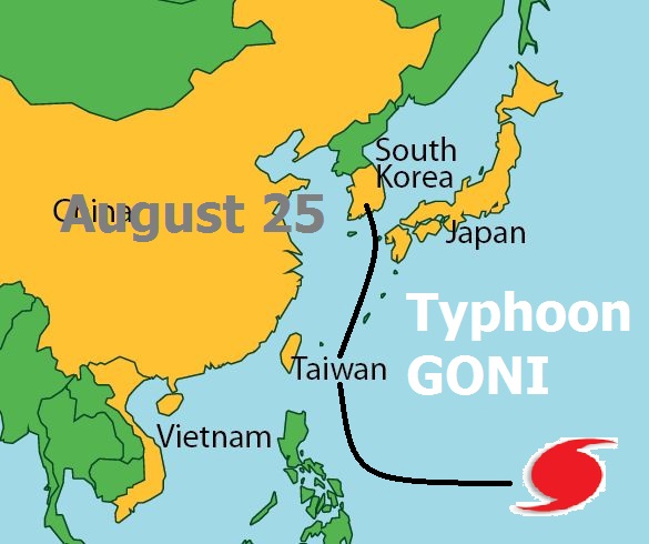
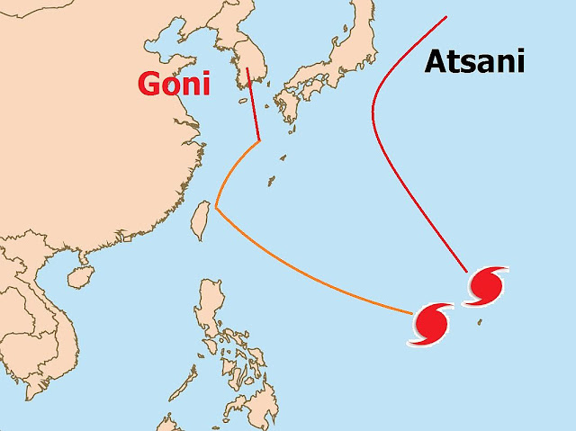
Typhoon Goni is a powerful typhoon now with winds of 220 km/h. It has passed the eastern coast of Taiwan and is now barreling through the East China Sea. Our prediction is it is going to hit south eastern part of South Korea tomorrow evening, Tuesday, August, 2015.

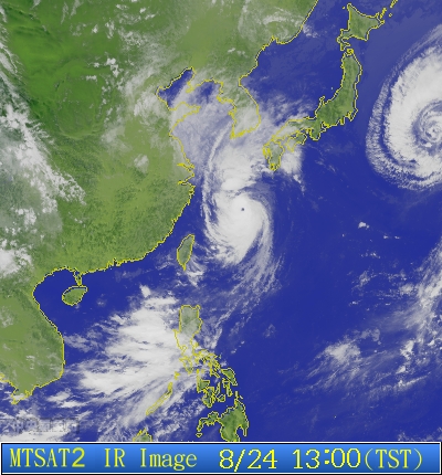
Latest satellite image typhoon GONI August 24, 2015
Latest satellite image of typhoon Goni taken at 0153 GMT, August 24, 2014

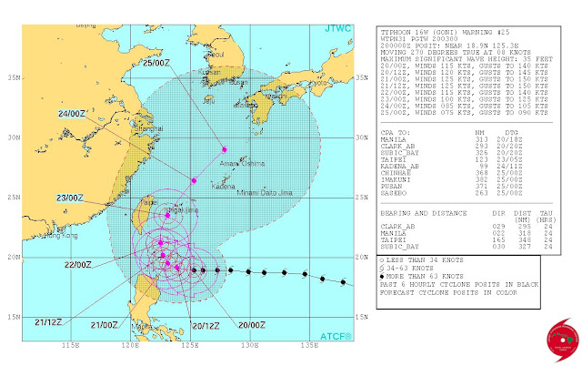
Other forecast agencies like the JTWC forecast that typhoon Goni will move right between Japan and South Korea. We think it is going to take a slightly westerly path through Korea.

The most affected provinces of South Korea will be South Jeolia, South Gyoengsong, and North Gyoengsong. The tropical cyclone will then move into the Sea of Japan and curve and enter North Korea in North Hamgyong province and then into China on August 26.

It will weaken considerably before landfall into North Korea and China but South Korea will face powerful winds in excess of 140 kmh.

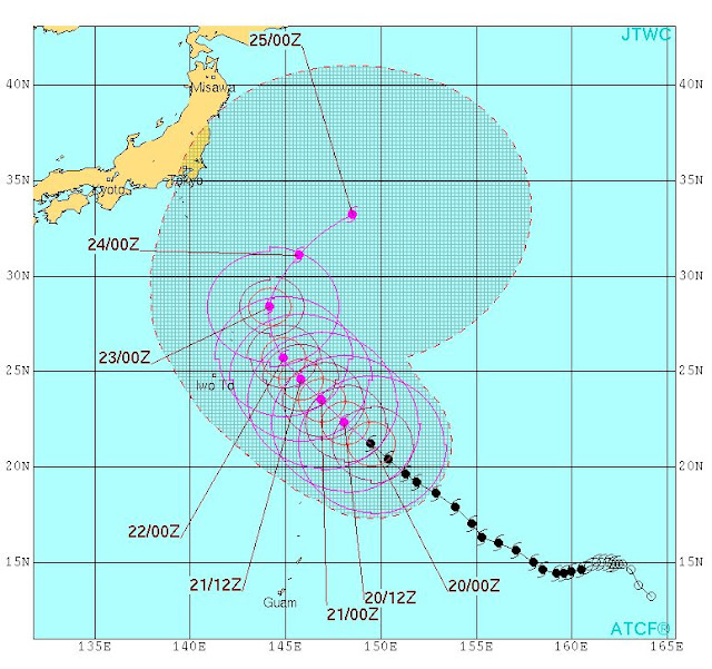
Track forecast Typhoon Goni North West Pacific Ocean 2015
Track Forecast for typhoon GONI by the JTWC. We believe it will move right through south-eastern part of South Korea on Tuesday night
 Tropical cyclone Goni is going to weaken in the next 24 hours. Presently it is a category 4 hurricane. By the time it makes landfall into South Korea it will weaken into a category 1 storm. By the time it enters North Korea and China it will be a tropical depression. Weaker winds but lots and lots of rainfall.

The province of Jilin will be most affected. The cyclone will still be a powerful one when it enters China with winds of 80 km/h. So North Korea and China are in for strong winds and heavy rainfall on late Wednesday.

Track the storm
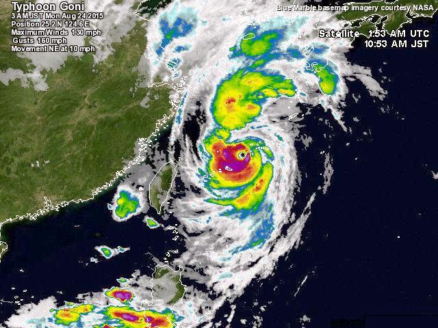
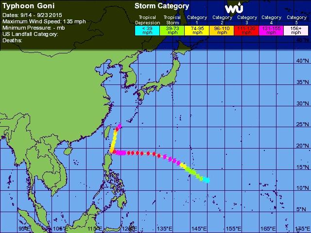
Track history Tropical cyclone Goni August 2015

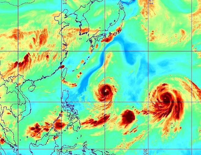
Latest infra-red satellite image typhoon goni august 24
LATEST INFRA-RED SATELLITE IMAGE TYPHOON GONI AUGUST 24, 2015

Share this PostPin ThisShare on TumblrShare on Google PlusEmail This

Typhoon Goni To Hit Kyushu, Japan, South Korea August 25, 2015

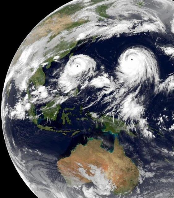
SATELLITE IMAGE TYPHOON GONI

Goni is a kid brother of super typhoon Atsani which is barreling north into the Pacific Ocean giving Japan a fright. But tropical cyclone Goni is no midget. It is already a category 4 hurricane if we use American terminology with winds of 105 knots (190 km/h).

It is presently passing by Luzon in Philippines. Heavy rains are reported from northern Philippines with the coast being very windy as the periphery moves by.

On August 22, Goni will pass the eastern coast of Taiwan but at a distance of about 200 kilometers. Even then the effect will be considerable on the eastern parts of the country which will face torrential rains and winds in excess of 120 km/h.

Though typhoon Goni will intensify in the next two days as it passes Taiwan, it will not achieve super typhoon status. But it will then have a central minimum pressure of 913 millibars. A dangerous storm.

As it moves towards Japan after that it will start weakening. It will move through Kyushu, right through Nagasaki. Kyushu and Chukogu districts of Japan will be badly hit.

The weakening storm will then move through South Korea and then into northeast China on August 26, 2015. There will be very heavy rains in South Korea and Hebei, Liaoning provinces of China.

See the storm live at CYCLONE TRACKER

Track forecast typhoon Goni Taiwan South Korea Japan August 2015
TRACK FORECAST AND EXPECTED WIND SPEEDS (IN KNOTS) FOR TYPHOON GONI BY JTWC. THE CYCLONE WILL MOVE THROUGH SOUTHERN JAPAN INTO SOUTH KOREA ON AUGUST 25-26 AFTER WEAKENING.

Share this PostPin ThisShare on TumblrShare on Google PlusEmail This

SUPER TYPHOON ATSANI NOT TO HIT JAPAN

Super Typhoon Atsani is a monster now throwing winds of 135 knots (250 km/h). In a couple of days it is is going to intensify even more. It will move threateningly towards Japan but veer  away back into the Pacific Ocean on August 25, 2015, Tuesday.


Typhoon Atsani West Pacific Ocean August 2015
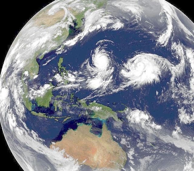
TYPHOON ATSANI IN THE WEST PACIFIC SATELLITE IMAGE AUGUST 20, 2015, 0300 HRS GMT. GONI IS SEEN ON THE LEFT

The tropical cyclone is presently 925 kilometers from the Japanese island of Iwo Jima. Sustained winds speeds are 250 km/h. The JTWC (Joint Typhoon Warning Center) believes typhoons Atsani is not going to get any stronger.

We beg to differ.

The storm is going to intensify further in the coming days and tun into a super super typhoon by Sunday having a central minimum pressure of 900 millibars. Our guess is the wind speeds then will reach an astounding 300 km/h, making it one of the most powerful storms on record.

It is not going to hit central Japan near Tokyo. It will move dangerously close but it will turn away abruptly on August 15, 2015, Tuesday.

But the Japanese Island of Iwo Jima is going to be affected badly. Not surprising when a 250 km/h+ typhoon moves by.

Atsani is going to wreck the Pacific Ocean shipping lanes as it is going to meander around  for a week still a powerful storm. A nightmare for the cargo ships in the north Pacific Ocean.

See the storm live at CYCLONE TRACKER

TRACK FORECAST tYPHOON ATSANI JTWC
TRACK FORECAST FOR TYPHOON ATSANI BY THE JTWC. WE DIFFER. WE THINK TYPHOON ATSANI IS GOING TO BECOME EVEN MORE POWERFUL. AND IT WILL PASS CLOSER TO CENTRAL JAPAN THAN THE JTWC ESTIMATE

Share this PostPin ThisShare on TumblrShare on Google PlusEmail This

Typhoon GONI Will Hit South Korea August 25, 2015

Typhoon Goni which is dangerously hovering in the West Pacific will turn into a very powerful cyclone and is expected to Hit South Korea on August 25, 2015. It will pass close by Luzon in Philippines and Taiwan soon.


Typhoon Goni Track forecast Pacific Ocean August 2015 South Korea
Typhoon Goni track forecast. It is likely to hit South Korea on August 25, 2015

The Western Pacific Ocean has spawned two powerful typhoons simultaneously, which is surprising. If forecasts are to be believed both Goni and Atsani are headed to super typhoon-dom. 

Soon to be super cyclone Atsani is not so worrying as it will mainly traverse uninhabited areas and may threaten central Japan On August 23, 2015. Our prediction is Tokyo is safe as Atsani will swing away back into the ocean without hitting Japan.

But Typhoon Goni is going to give many countries cause to worry. After passing Guam it is intensifying and the Joint Typhoon Warning Center says it will reach wind speeds of 220 km/h on August 21, when it will pass by Luzon in Philippines. Only the periphery of the storm will touch northern Philippines.

After that typhoon Goni will move north and intensify. It is possible it may become a super typhoon as the warm waters of the East China Sea gives it extra vigor.

It will move past Taiwan on August 22, but at a safe distance. Eastern coast of the country will experience stormy rain and winds as Goni passes by.

On August 25, 2015 it will moves through western Kyushu Island of Japan and then enter South Korea. It will weaken a little before landfall.

The provinces of South Jeolla and South Gyoengsong of South Korea will be the worst hit.

See the storm live at CYCLONE TRACKER

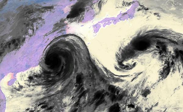
Typhoon Goni Atsani water vapor satellite image west pacific ocean
Water vapor satellite image of the West Pacific Ocean showing Typhoon Goni and Atsani.

Share this PostPin ThisShare on TumblrShare on Google PlusEmail This

Pacific Typhoons Goni Atsani Threaten Philippines, Taiwan, Korea Japan

The two typhoons Goni and Atsani hovering in the West Pacific Ocean could threaten Philippines, Taiwan, Korea and Japan in the coming days this August 2015.


Track forecast typhoon Goni Atsani north west pacific ocean august 2015
Track forecast for Pacific Ocean typhoon Goni and Atsani. Goni will move close by Luzon in Philippines and northern Taiwan. Future super typhoon Atsani poses a threat to central Japan on August 26, 2015.
Though latest forecasts by leading reliable computer models say now that none of these cyclones will hit any country directly but it is difficult to say so with any emphasis as tropical storms obey no computer models however thorough they may be.

A couple of days back we had said in our prediction that Typhoon Goni might hit China at Shanghai but the expected track has changed a little. The tropical cyclone is to move much closer to Luzon in Philippines than earlier expected on August 21, 2015.  It will kiss past the northeastern coast of Taiwan on August 23, 2015 and then weaken. It will then swing towards southern Japan and then change direction and enter South Korea as a  tropical storm on August 27.

Typhoon Goni will probably not metamorphose into a super typhoon (Unlike Atsani) but it will still be  a dangerous storm with a central minimum pressure of 914 Mb when it moves past Luzon. Winds of 200+ km/h. It is possible it may reach super typhoon status.

The authorities in Philippines, Taiwan, Korea and Japan will have to keep a very close watch on cyclone Goni.

Typhoon Atsani in contrast only threatens central Japan. And in a few days it will turn into a howling monster of a storm. A super typhoon with a minimum pressure of 905 Mb. A dangerous powerful cyclone.

Atsani will move through Iwo Jima and go very close to central  Japan threatening Tokyo on August 26, 2015. Our calculation presently is that it will not hit Japan but swing away north east in northern Pacific Ocean and turn into a mid-latitude cyclone threatening the Aleutian Islands.

See the storm live at CYCLONE TRACKER

Satellite image typhoon Goni Atsani West Pacific Ocean august 2015
Typhoons Goni and Atsani in the West Pacific Ocean are going to intensify and turn into very powerful storms in the coming days and they threaten Philippines, Taiwan, Korea and Japan. in the next 10 days. They are slow moving cyclones and hence lethal.

Share this PostPin ThisShare on TumblrShare on Google PlusEmail This

2 Future Pacific SUPER TYPHOONS Goni, Atsani Threaten China, Japan

The over-active West Pacific Ocean has given birth to typhoons Goni and Atsani which are destined to turn into  super typhoons soon and may threaten Taiwan, China and Japan in a few days this August 2015.


Track forecast Typhoon Goni Atsani West Pacific August 2015
EXPECTED PATH/TRACK FORECAST OF NORTH WEST PACIFIC OCEAN TYPHOONS GONI, ATSANI AUGUST 2015

It is hard to say which of the storms IS going to turn into a bigger cyclone. Typhoon Goni? Typhoon Atsani? Present forecasts say both will become super typhoons soon. That means sustained wind speeds in excess of 130 knots (240+ km/h).

Goni is growing now as it moves over Guam now. It will move in a WNW direction in the coming days. It is not going to touch Philippines. It is safe.

But Taiwan may be in for a bad time in a week's time around August 22, 2015 as Goni, (Will be a howling giant by then) will come visiting. It is possible the storm may move just past the northern coast of Taiwan and go on and hit mainland China at Shanghai on August 24.

The typhoon will have a minimum central pressure of 915 Mb then. That spells bad news for Shanghai. A very big, mean, powerful destructive cyclone.

The other big bad guy in the Pacific, typhoon Atsani will swing north soon, giving Guam a miss and grow into a super typhoon in a couple of days.

Atsani is expected to have a central pressure of 896 Mb! You will recollect the Atlantic super cyclone Wilma had a similar minimum pressure.

As to its future route, it is going to pass Iwo Jima, that is for sure. But after that it may swing dangerously towards central Japan. Whether it hits the country or not at Tokyo is to be seen. Our guess is it will not, but swing away but dangerously close to Tokyo by August 24, 2015.

The two typhoons will have many Asian countries worried in the next few days.

See the storm live at CYCLONE TRACKER

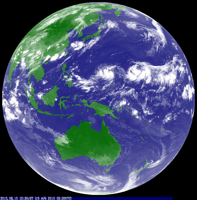
Typhoon Goni typhoon Atsani Pacific ocean august 2015
PRESENT (AUGUST 15, 2015) INFRA RED IMAGE OF THE WEST PACIFIC SHOW THE FLEDGELING TYPHOONS GONI AND ATSANI. IN A FEW DAYS THEY WILL BOTH TURN INTO SUPER TYPHOONS THREATENING CHINA AND JAPAN

Share this PostPin ThisShare on TumblrShare on Google PlusEmail This

Monsoon 2015 Active in North, Eastern India Till August 20

The Indian monsoons will remain active in central, northern and eastern India till August 20, 2015. Western and northwest India will remain mainly dry.


This has been a mainly disappointing rainy season for the states of Gujarat and Rajasthan. Barring the flooding periods in June (the Arabian Sea depression) and July these states have seen long dry periods.

The present forecasts by leading computer models predict the monsoon will keep drenching the states of West Bengal, North Eastern States, Bihar, Madhya Pradesh, Odisha and parts of Uttar Pradesh. In other the usual suspects. There might be localised heavy downpours but there are no huge area drenching lows or depression in sight in the near future.

A low pressure area is likely to form in a day or two near the Odisha coast but it is going to be a weak fellow. Not strong enough to reach western or northwestern India.

But computer models might go wrong. Why do we say that?

We have discerned a trend that the Pacific Ocean and the Indian Ocean take turns in becoming active. When one is throwing out a typhoon or a big rainmaker system the other one goes relatively inactive.

Presently it is the turn of the Pacific Ocean. The big monster Soudelor has smashed Taiwan and is hitting China which cowers in expectations of flood in north eastern part of the country. The other guy in the Pacific, Molave, is turning out to be a sissy. A small tropical storm which will swirl away northeast away from Japan.

So in a few days time, it will be the turn of the Indian Ocean to become vigourous again. That means monsoons getting strong again in South Asia. This may happen around August 20, 2015.

We hope it happens. The dire forecasts of a drought by the IMD has left us depressed and shaken.

EPILOGUE

Our hearts go out to the folks in Oman and UAE. The temperature is touching 46 degrees centigrade! We have experienced this kind of heat and we know how it feels. One prays for a post monsoon cyclone in the Arabian Sea this year.

UPDATE AUGUST 9, 2015

Predictions have changed. Bad news for Indian monsoon. The Pacific Ocean is not going to stay satisfied with typhoons Soudelor and Molave. Within a week two more typhoons (Goni and Atsani) are going to be spawned in the area. One of them is most probably going to hit Philippines.

Anyway. Goni and Atsani means the Pacific Ocean is going to remain in overdrive and the Indian Ocean will remain in a dormant stage. So a weak monsoon spell will continue till the end of August 2015.

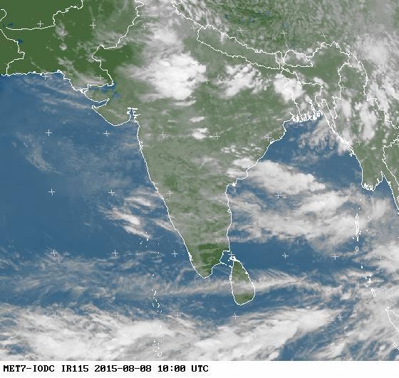
Satellite image south asia august 8 2015 monsoon forecast
AUGUST 8, 2015 1000 HOURS GMT SATELLITE IMAGE SOUTH ASIA

Share this PostPin ThisShare on TumblrShare on Google PlusEmail This

Big Typhoon SOUDELOR Weakening Before Hitting China, Goni and Atsani Waiting

Typhoon Soudelor is a massive typhoon and it leaves behind a devastated Taiwan. It has started to weaken and will enter China at Fujian Province just south of Fuzhou August 8, 2015 noon GMT.


satellite image typhoon soudelor molave august 2015
SATELLITE IMAGE OF TYPHOON SOUDELOR AND TROPICAL STORM MOLAVE TAKEN AT 0000 HOURS GMT AUGUST 8, 2015

The tropical cyclone had a central minimum pressure of 915 Mb just before it hit Taiwan. That is a big big bad storm. Winds 0f 200+ kph, gusts upto 250 kph.

And it passed just south of the country's capital Taipei. The city must have been badly affected.

Luckily for China Soudelor is weakening as it prepares to make landfall into mainland China today evening. Ground Zero will be the Fujian coast just south of Fuzhou.

Even a weakening storm as this one will be something to watch out for. Winds of 150+ kph and even more worrying the torrential rain. A weakened cyclone throws down a lot of rain.

Withing the next 24 hours, typhoon Soudelor will shrink into a low pressure area. But it will travel right through north eastern China in the next 2-3 days. One can expect rainfall in the provinces of Jiangxi, Hubei, Anhui, Henan, Jiangsu and southern Shandong. The low pressure area will then move into Korea. Phew!

Soudelor has a lot of energy and moisture and it will traverse quite a distance in China in the next few days bringing floods in many areas.

Meanwhile the other tropical storm in the West Pacific, Molave, is quite harmless in contrast. It will never intensify into anything big and it will not make landfall in any populated landmasses. It will swing away from Japan and move north-easterly harmlessly into the cold North Pacific. A nuisance to shipping lanes perhaps but otherwise a harmless guy.

TYPHOONS GONI AND AFSANI IN THE WAITING

There is bad news for the Philippines. After typhoon Soudelor and tropical storm Molave, the Western Pacific is going to throw out two more typhoons, Goni and Atsani within a week. One of them will probably threaten Philippines around August 25, 2015.

Satellite image typhoon Soudelor Molave august 2015
WESTERN PACIFIC OCEAN SATELLITE IMAGE AUGUST 9, 2015. TYPHOON SOUDELOR HAS ENTERED CHINA AND WEAKENED. MOLAVE IS SWINGING AWAY. WITHIN A WEEK TYPHOONS GONI AND ATSANI WILL BE COMING


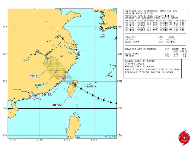
Typhoon Soudelor China Fujian Province Taiwan August 2015
TYPHOON SOUDELOR WILL ENTER FUJIAN PROVINCE, CHINA AUGUST 8, 2015 AFTERNOON LOCAL TIME WITH 150 KPH WINDS

Share this PostPin ThisShare on TumblrShare on Google PlusEmail This

Latest Forecasts/Updates


Popular Posts

Search This Site