Typhoon Chan-Hom To Hit China At Zhejiang Province July 11, 2015

Typhoon Chan-hom is going to intensify further in the next 48 hours into a powerful storm and hit the Chinese coast at the southern part of  Zhejiang province on July 11  local time. Shanghai will not be affected. It is safe.

Its outer periphery will touch northern Taiwan (Including Taipei) on July 10, 2015. The country will receive stormy rain and nothing else as Chan-hom will move into China. Taiwan is safe.

Before hitting the country, it will be a powerful cyclone with a central minimum pressure of 926 Mb. Winds of 230 km/h. Gusts up to 260 km/h.

Though the typhoon will weaken before landfall into China, the coastal area will receive torrential downpour and very strong gale.

typhoon chan-hom july8
TYPHOON CHAN-HOM AS SEEN AT 0600 GMT JULY 8, 2015

Share this PostPin ThisShare on TumblrShare on Google PlusEmail This

Pacific Typhoons Chan-Hom, Linfa, Nangka... Headed Where?

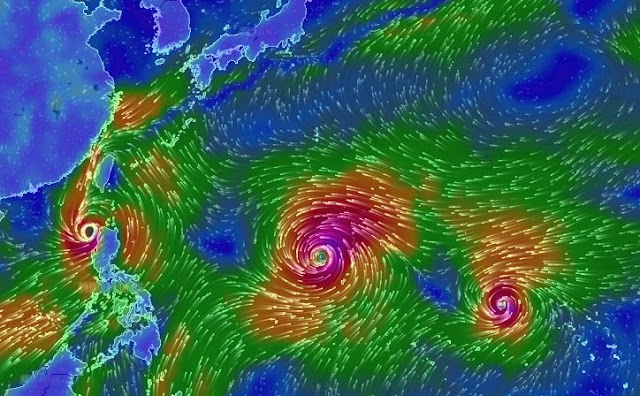
Where will the three West Pacific Ocean typhoons, Chan-hom, Linfa and Nangka go? Opinions differ. But Taiwan and Fujian province of China seem to be in for rough weather.

satellite image tropical cyclone Chan-hom linfa nangka july 6 2015
Satellite image taken at 0900 GMT, July 6, 2015, showing typhoons Chan-hom, Nangka and Linfa


The ocean is over active now, hurtling tropical cyclones and storms by the fistfuls. Let us discuss the forecasts for each of these...

TYPHOON CHAN-HOM

It has moved past Guam Island and if the JTWC is to be believed, it is headed for a super typhoon status soon in a couple of days, that is by July 9, 2015. It is expected to move past Okinawa by Friday morning, a few hundred kilometers away. But since Chan-hom will be so powerful then, expect very stormy weather at Kadena.

After that what? Forecasts differ. The JTWC says it will go onto hit Shanghai head on July 11, 2015. We think it will make landfall into Fujian province in China  just south of Fuzhou. It will weaken before impact on July 11. But it is going to kiss the northern part of Taiwan before that on July 10. Taipei and Chilung will be hit by winds of 250 km/h.

TYPHOON LINFA

Tropical cyclone Linfa is smaller in comparison. It has just passed northern Philippines and is going to intensify as it heads north towards the south-western coast of Taiwan. It will have winds of 60-70 km/h when it kisses the country's coast at Kaohsiung and Tainan on July 10, 2015. It will weaken into a low and head to Fujian in China after that.


TYPHOON NANGKA

This one is in the league of Chan-hom. A possible super typhoon. Luckily it is not going to head to heavily populated land masses. But it is going to move perilously close to the Japanese island of Iwo Jima on July 14, 2015. It is possible it may hit it directly. Predictions differ on the track of Nangka. 

The first possibility is it will kiss Iwo Jima and swing away from the east coast of Japan harmlessly. Another option is it will swing westwards and move right through the southern Japanese islands of Oshima and Okinawa. A dangerous possibility.
Share this PostPin ThisShare on TumblrShare on Google PlusEmail This

Monsoon Rains In Eastern, Central India Till July 20, 2015

Monsoons will remain active over eastern, northeastern and parts of northern India in the next 15 days.


The present spells of rainfall in the states of West Bengal, Bihar, parts of Uttar Pradesh, the entire Indian northeast and Bangladesh is expected to continue in the coming 15 days. The region has a string of low pressure areas hovering above which will continuously feed rain to the above mentioned states.

The wet spell may occasionally stretch to western Uttar Pradesh, Delhi, Haryana and Punjab but most of the precipitation will be concentrated in eastern India. Not to forget the areas on the foothills of the Himalayas. Namely Sikkim, Nepal, Uttaranchal and Himachal.
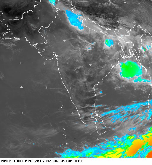
monsoon update july 6 2015 india satellite image
This rainfall satellite image was taken at 0500 GMT, July 6, 2015

A low pressure will form near the Odisha coast on Friday, July 10, 2015. This system will be a big rain maker and move through Chattisgarh and onto Madhya Pradesh after that. But it will start weakening and is not likely to reach western India.

The dire predictions of the Indian Meteorological Department seems to be coming true. The monsoon appears weak. In July usually the Bay of Bengal hurls lows and depressions one after another that cut across central and western India and bring rains to Gujarat, Rajasthan and Haryana-Punjab.

This year not one such system has formed. Gujarat was lucky to have that Arabian Sea depression in late June. Rajasthan still thirsts for rains.

The Bay of Bengal low that will form on July 10, 2015 will be a weak one. Weak low pressures equals weak rainy season this year.

The Western Pacific Ocean is presently spewing a string of powerful typhoons, one after another. Typhoons Chan-Hom, Linfa, Nangka, And there are a couple of  Invests in the waiting list. Phew! Its sucking off steam from the monsoons.
Share this PostPin ThisShare on TumblrShare on Google PlusEmail This

Latest Forecasts/Updates


Popular Posts

Search This Site