Monsoon Forecast: Heavy Rains Expected In Bengal, Bihar Till June 27, 2015

The low pressure area which is presently over Bangladesh will move through West Bengal and Bihar by June 27, 2015 bringing heavy rains to these states.


Very heavy rainfall is expected in Bangladesh today. The rains will shift to north Bengal and then onto Bihar by tomorrow.

Very heavy rains are expected in sub Himalayan West Bengal and Bihar in the next 48 hours.

One fears of flooding in Bihar by Sunday.

The rains will ease by Monday as the low will dissipate by then.. There may be rainfall in eastern Uttar Pradesh too in the next 48 hours.

monsoon rainfall bihar west bengal june 2015
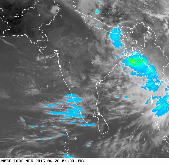
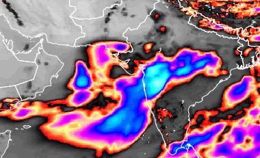
The latest (0430 hours GMT, June 26, 2015) rainfall satellite image shows rains in North Bengal presently.


Share this PostPin ThisShare on TumblrShare on Google PlusEmail This

After Gujarat, Monsoon Will Shift To Uttar Pradesh. Heavy Rains By June 27, 2015

The next deluge spot in India after Gujarat is Uttar Pradesh. The reason being the Bay of Bengal low will collide with the remnants of the Arabian Sea low in the next 3 days. The result will be flooding.


The Bay of Bengal low is now in Banglasdesh. In the next two days it will move through West Bengal onto Bihar. The Arabian Sea rain system, which flooded Saurashtra is presently in northern Madhya Pradesh. In the next two days it will move towards eastern Uttar Pradesh. On June 27, June 2015, the two system will collide over the Uttar Pradesh-Bihar border.

The result will be heavy rains in the region.

So by the 27th of June we can envisage good rainfall activity in the following areas. Northern Madhya pradesh and Uttar Pradesh due to the Arabian Sea system. Bangladesh, West Bengal, Bihar and eastern Uttar Pradesh owing to the Bay of Bengal low pressure system.

The next big activity in monsoon 2015 will be a low pressure area forming in the Bay of Bengal around July 5, 2015. This is expected to move through Andhra, Chattisgarh and Madhya Pradesh. But this will be a weak system.

The reason? The expected massive typhoon that will form in early July, 2015 in the Western pacific and which will hit Hongkong, Macau and northern Vietnam.

There is a deep relationship between the storm activity in the north Indian Ocean and West Pacific. Especially with the strong prevailing El Nino the storm activity is rationed between the two oceans. One gets active then the other gets passive.

Since two typhoons are expected in early July in the Western Pacific, one can assume that there is going to be big lull in the Indian monsoons in the first half of July 2015.

bay of bengal low monsoon 2015 bangladesh
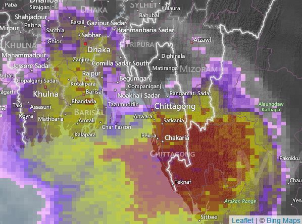
The Bay of Bengal low is presently about to enter Bangladesh.

Share this PostPin ThisShare on TumblrShare on Google PlusEmail This

Arabian Sea depression to hit South Gujarat at Surat

Update: June 23, 2015, 1030 hours GMT

The European model has said depression 97A will move in a north easterly direction in the next 24 hours. Coastal Amreli district then onto South Gujarat.

The GFS in its latest data issued at 0600 GMT predicts a more northerly movement during next 24 hours. Right through Saurashtra on to north and central Gujarat.

Who will win?
-------------------------------------------------
IMD confirms 97A will move through Diu, Amreli district and move to South Gujarat.

The Arabian Sea Deep Depression will make landfall at Diu and then move through coastal Amreli and Bhavnagar districts to South Gujarat at Surat in the next 24 hours.

YESTERDAY’S  DEPRESSION  OVER  NORTHEAST  AND  ADJOINING  EASTCENTRAL  ARABIAN  SEA MOVED  EAST-NORTHEASTWARDS,  INTENSIFIED  INTO  A  DEEP  DEPRESSION  AND  LAY CENTRED  AT  0300  UTC  OF  TODAY,  THE  23RD  JUNE  2015,  OVER  NORTHEAST  ARABIAN  SEA  OFF SOUTH  GUJARAT  COAST  NEAR  LATITUDE  20.5°NORTH  AND  LONGITUDE  70.5°EAST,  ABOUT  50 KM  WEST-SOUTHWEST  OF  DIU.    IT  WOULD  MOVE  EAST-NORTHEASTWARDS  AND  CROSS SOUTH  GUJARAT  COAST  NEAR  DIU  AS  A  DEEP  DEPRESSION  BY  TODAY,  THE    23RD  JUNE  2015 AFTERNOON  .   ACCORDING  TO  LATEST  SATELLITE  IMAGERY,  INTENSITY  OF  THE  SYSTEM  IS  T  2.0.  THE CONVECTIVE  CLOUD  MASS  IS  SHEARED  TO  THE  WEST  OF  THE  SYSTEM  CENTRE.  LOWEST CLOUD TOP  TEMPERATURE  IS  -88.0°C.  ASSOCIATED BROKEN  LOW  AND  MEDIUM  CLOUDS  WITH EMBEDDED  INTENSE  TO  VERY  INTENSE  CONVECTION  OVER  ARABIAN  SEA  NORTH  OF LATITUDE  14.0°NORTH  TO  22.0°NORTH  AND  EAST  OF  LONGITUDE  62.0°EAST.  THE  ESTIMATED CENTRAL  PRESSURE  IS  989  HPA.  MAXIMUM  SURFACE  WIND  SPEED  IS  ABOUT  30  KNOTS GUSTING  TO  40  KNOTS  AROUND  THE  SYSTEM  CENTRE.  SEA  CONDITION  IS  VERY  ROUGH AROUND THE  SYSTEM CENTRE  AND ALONG  AND  OFF  GUJARAT  COAST. 
Share this PostPin ThisShare on TumblrShare on Google PlusEmail This

DEPRESSION WILL INTENSIFY RAPIDLY, HIT SAURASHTRA TONIGHT

The latest GFS forecast data that is coming in says Arabian Sea deep depression 97A may rapidly intensify in the coming 12 hours, perhaps into a tropical cyclone and hit the Saurashtra Coast at Veraval today midnight. That is 0000 hours IST, June 23, 2015, Tuesday.


It is possible that wind speeds at impact will be 70-80 km/h, gusts upto 90 km/h.

The gale will be accompanied by torrential rains.

The deep depression/cyclone will swing North after making landfall and move into Kutch.

The most affected districts will be Gir Somnath, Porbandar, Junagadh, Rajkot, Morbi, and Kutch.

One wonders if the authorities are taking this possible threat seriously. The worry is if the GFS forecast turns true, there are just 14 hours before impact.

We are constantly monitoring what various computer forecasts models are saying and also the latest IMD (Indian Meteorological Department) updates.

Please keep in touch for breaking forecasts.

arabian sea depression 97A cyclone forecast
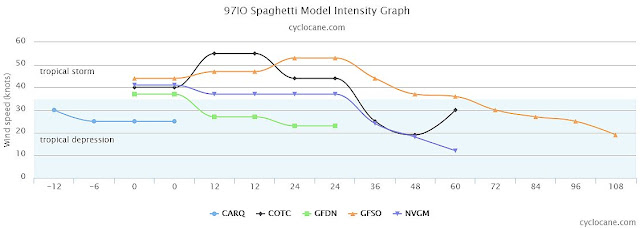
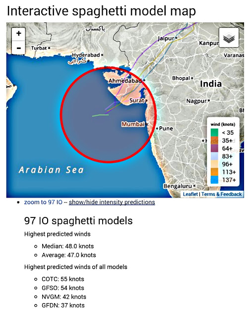
Arabian Sea Storm Intensity Forecast from Cyclocane. Only one model says it will not turn into a tropical storm.

arabian sea depression cyclone 97A forecast
Cyclone tracking site cyclocane.com says Arabian Sea depression 97A will be a tropical cyclone

Share this PostPin ThisShare on TumblrShare on Google PlusEmail This

Arabian Sea Deep Depression (Or Cyclone?) To Hit Kutch Early June 24, 2015

Weather update South Asia: June 22, 2015.

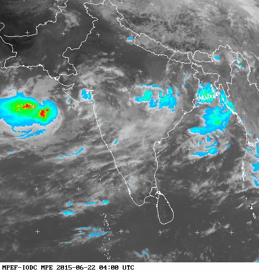
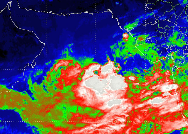
The low pressure area in the Arabian Sea has organised into a depression. At 0000 hours GMT it lay 275 kilometers WSW of Veraval, Gujarat. The southern quadrant of the system is throwing winds of 85 km/h. The Eumetsat MPE image was taken at 0400 hours GMT today. The red color denotes heavy rainfall. The system will now move towards the Gujarat coast. Rainfall activity will pick up from tomorrow itself in the region.

arabian sea depression june 2015 kutch gujarat monsoon 2015
RAINFALL SATELLITE IMAGE OF THE ARABIAN SEA DEPRESSION 97A AT 0400 GMT TODAY, JUNE 22, 2015


Depression 97A is expected to enter the coast of Kutch at Lakhpat on the morning of June 24, 2015, Wednesday. The system is expected to intensify into a deep depression as it moves to the Gujarat coast.

Very heavy rainfall is expected in Kutch, Saurashtra and southern Sindh from late Tuesday evening. The rains will extend to north Gujarat and western Rajasthan by Friday.

Winds of 40-50 km/h, gusts up to 60 km/h, will lash the areas from Tuesday night (local time). In short, wind speeds just short of a tropical cyclone.

We have a suspicion that the system may intensify into a cyclone by landfall. The GFS forecast shows the expected central minimum pressure at landfall on early Wednesday morning to be 987 Mb. Now according to the Dvorak scale that equals a category 1 hurricane. That is wind speeds of 120 km/h. See the link for details .......https://en.m.wikipedia.org/wiki/Dvorak_technique

We expect that 97A may intensify into a tropical storm by tomorrow morning. That is Tuesday morning. June 23, 2015.

97A SEEMS TO BE A CYCLONE IN THE MAKING 

 Our estimate is the depression is 300 kilometers southwest of Veraval in Saurashtra-Kutch. The southern quadrant of the system is the windiest. 85 km/h. The other quadrants have winds ranging from 40-65 km/h. We think this is already a tropical cyclone. The rest is nitpicking on technicalities. Latest data by GFS rules out the possibility of a big tropical cyclone. Technically it may be called a deep depression but analysing the latest GFS forecast we see 70-80 km/h winds hitting Kutch on Wednesday. That is a cyclone by any definition.
---------
Latest update: June 22, 2015, 1600 hours GMT

DEEP DEPRESSION 97A TO HIT SAURASHTRA TUESDAY NIGHT

The present depression 97A in the Arabian Sea will hit the Saurashtra coast between Dwarka and Porbandar on late evening tomorrow that is on June 23, 2015, Tuesday.

It will move through Kutch and then move onto Rajasthan and then Delhi. 

Very heavy rainfall is expected in Saurashtra and Kutch in the next 72 hours starting tomorrow afternoon. There may be showers in Sindh on Wednesday.

The rains in Saurashtra and Kutch will be accompanied by strong winds of 50-60 km/h till Thursday.

This forecast is based on NCEP GFS latest data issued just now.
------
Meanwhile the European forecast model  in its latest forecast  today June 22, 2015, 1200 hours GMT data, says 97A is already a tropical storm with a central pressure of 982 Mb. Quite a storm.

It predicts the storm will move straight east, touch southern Saurashtra at Diu in the next 24 hours and hit South Gujarat near Vapi-Valsad on Wednesday evening.
arabian sea depression 97A june 2015 hujarat
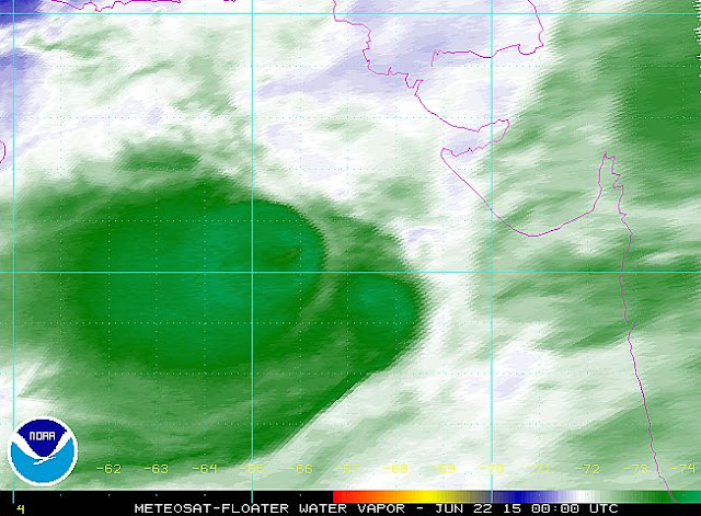
NOAA WATER VAPOR IMAGE OF ARABIAN SEA DEPRESSION 97A AT 0000 HRS GMT, JUNE 22, 2015

Share this PostPin ThisShare on TumblrShare on Google PlusEmail This

Gujarat Stares At Stormy Rain As Arabian Sea Deep Depression (Or Cyclone) Will Hit June 25, 2015

The present low pressure system in the Arabian Sea off the coast of Gujarat will intensify into a deep depression, perhaps even a tropical cyclone (Komen) and hit the state on June 25, 2015.


The system presently lies a few hundred kilometers south west of Veraval. In the coming 48 hours it will continue to drift away from the Gujarat coast. On Monday, June 21, 2015, it will start turning back towards Gujarat.

It is likely to enter Saurashtra-Kutch area of Gujarat on Thursday, June 25, 2015. It will hovers over the state till Saturday then dissipate. Under its influence very heavy rainfall accompanied with strong winds of 60-70 km/h are expected in Gujarat, especially in the Saurashtra-Kutch region from Wednesday itself.

The rains will continue from Wednesday till Saturday, that is from June 24-27, 2015. There may be flooding in some areas. The damage from the winds could be substantial.

The system will reach its peak intensity on June 21, 2015, reaching a minimum central pressure of 985 Mb. That is a tropical cyclone. It will be a borderline case between a deep depression and a tropical cyclone.

The official met agencies call 97A (the number given to it by NOAA- National Oceanography and Atmospheric Administration, an US agency) an upper air cyclonic circulation now. It is that presently. But it is organising itself into a well defined low pressure area. It will turn officially into a low by tomorrow morning. It will then intensify further possibly into a tropical cyclone by Tuesday, June 23, 2015. Or a deep depression. A borderline case. It will weaken into a low by the time it enters Gujarat by June 25, 2015. But it will bring a lot of stormy rainfall.

There is a possibility that the system may hit Gujarat earlier as one of the reliable forecast models is hinting at it. Please keep in touch. We will provide running updates as we get further information.

LATEST UPDATE June 21, 2015. 1030 GMT.

The system 97A will become organized into a deep depression or a tropical cyclone by Monday evening. From Tuesday, June 23, 2015, it will start coming back.

It will weaken a little before it enters the Saurashtra-Kutch western coast on Thursday, June 25.

arabian sea low deep depression cyclone gujarat june 2015
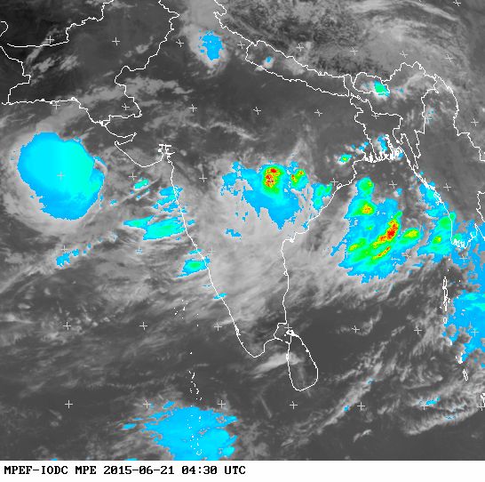
SATELLITE IMAGE TAKEN AT 0430 HOURS GMT JUNE 21, 2015 OF THE ARABIAN SEA RAIN SYSTEM 97A

Share this PostPin ThisShare on TumblrShare on Google PlusEmail This

Arabian Sea Low Pressure Area To Form Today (June 20, 2015) Off Saurashtra Coast

LATEST FORECAST UPDATE FOR ARABIAN SEA LOW


It will form today off the coast of Saurashtra region. Where will it go?


Two scenarios.

FIRST: it will stay close to the Saurashtra coast and intensify into a possible depression on Monday, June 22, 2015. It will make landfall into the region on Tuesday, move through central Gujarat, Madhya Pradesh and end up finally in West Bengal.

SECOND: it intensifies and move back into the Arabian Sea, goes quite near the coast of Oman, then turn back. It will make landfall into Kutch on June June 25, 2015 and move through western Rajasthan towards Delhi. Heavy rains likely in Kutch, Saurashtra, and Sindh from June 23rd onwards.

The upper air circulation (the low) extends up to 8 kilometers in the atmosphere.

The image below shows the current situation in Arabian Sea now (0300 UTC, June 20, 2015).


monsoon update forecast arabian sea low rain system 2015

Share this PostPin ThisShare on TumblrShare on Google PlusEmail This

A Big Rain Maker Low To Form In Arabian Sea Soon

After the Bay of Bengal, the Arabian Sea is going to spawn a deep depression in the next couple of days by June 21, 2015.

Perhaps this will be even a bigger system than the Bay of Bengal depression which is presently deluging Andhra Pradesh.

The low pressure area will form by Saturday near the coast of Saurashtra. After that there is some disagreements amongst the computer forecast models. So we draw out the two possible scenarios.

First scenario: The low forms tomorrow and then stays near the coast of Saurashtra region of Gujarat state for a couple of days and then makes landfall into the region on Monday.

The second scenario is the low develops near the coast of Saurashtra on Saturday, intensifies into a depression and then swing aways from the Saurashtra coast back into the sea. It takes a long walk. Goes quite near the Oman coast and then turns back and makes landfall into the Kutch-Sindh border areas on June 25, 2015.

Since the monsoons have set in the chance of the system turning into a tropical cyclone is low. But it may turn into a depression or deep depression, both of which are mean little siblings of a tropical cyclone.

So we can look forward to a lot of rain, perhaps windy, in Saurashtra, Kutch and perhaps Sindh in the coming days.

monsoon forecast june 2015
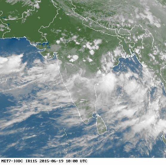
SATELLITE IMAGE (1000 HRS GMT JUNE 19, 2015) OF THE NORTH INDIAN OCEAN

Share this PostPin ThisShare on TumblrShare on Google PlusEmail This

Bay Of Bengal Depression To Push Monsoons Into North India: Heavy Rains In AP, Odisha, MP Expected

VERY HEAVY RAINS IN ANDHRA, ODISHA IN NEXT 3 DAYS


The current cyclonic circulation in the Bay of Bengal is going to intensify into a deep depression and move north along the Indian coast in the next 36 hours.


It will make landfall into Odisha on Saturday, June 20, 2015. As a result very heavy rainfall is expected in Andhra and Telangana in the next 36 hours. After that the rains will move into Odisha, Chattisgarh and Madhya Pradesh.

Andhra and Odisha will experience winds of 40-50 km/h. Especially the coastal areas of the states.

After June 23 the system will swing into Uttar Pradesh. As a result the monsoons will move into north India in the next seven days.

A special note of caution. This system is big and will sustain itself for one week. There is a very strong possibility of flooding in the states it will pass through. The most vulnerable states are Andhra, Odisha and Madhya Pradesh.

heavy rains Andhra Odisha Madhya Pradesh forecast June 2015
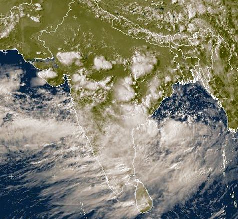
SATELLITE IMAGE OF BAY OF BENGAL AT 1200 HOURS GMT, JUNE 18, 2015

Share this PostPin ThisShare on TumblrShare on Google PlusEmail This

Monsoon Update: Expected Arabian Sea Rain System May Hit Mumbai June 23, 2015

ARABIAN SEA LOW: MODELS GIVE COFUSING SIGNALS

The expected path of the upcoming Arabian Sea low has changed. Now it may go to Mumbai on June 23, 2015.

The low will start off as a circulation and organize iinto a low by Sunday near the Saurashtra coast off Dwarka.

Another model predicts it will remain a trough not a low pressure area.

Models presently agree it will move to the Indian west coast by June 23, 2015.

But one wonders. The forecast models are saying different things every day. Our guess is it could go anywhere. Sindh. Gujarat. Or Maharashtra.

But we can say two things with certainty.

One. The Arabian Sea is going to turn very stormy in the coming days.

Second. The expected system will be a big rain maker. Where ever it will go, we are looking at a deluge.

Monsoon is complex. Reputed sites like AccuWeather and Wunderground rarely predict right if it is going to rain in your city today or not.
Share this PostPin ThisShare on TumblrShare on Google PlusEmail This

Two Storm Systems To Propel Monsoons To Indian Hinterland In A Week

Two low pressure areas (Perhaps tropical depressions) likely to form one each in the Bay of Bengal and Arabian Sea within the next three days will propel monsoons into the Indian interiors.


BAY OF BENGAL LOW TOMORROW, ARABIAN SEA SYSTEM TO FORM ON FRIDAY, JUNE 19, 2015.

The Bay of Bengal low will become well marked by tomorrow. In a couple of days it will turn into a deep depression and enter Andhra and Telangana. Very heavy rains have started in the coastal areas of Andhra which will increase as the system intensifies in the next 48 hours.

It is expected to move through Telangana, northern Maharashtra, western Madhya Pradesh and perhaps into Gujarat by June 23, 2015.

The low in the Arabian Sea will form on Friday, June 19, 2015. It will form just south of the Saurashtra Coast and just hover around in the same area for the next three days. There are chances this system may intensify into a depression. It will make landfall into Saurashtra on June 23, 2015, Tuesday and then move though North Gujarat into southeastern Rajasthan.

It will reach Delhi and western Uttar Pradesh by Friday.

For the uninitiated, please note that a low pressure area and depression are very akin to a tropical cyclone, only the winds are much less. But they are big rain makers.

So we see that within a week heavy rains will occur in Andhra, Telangana, parts of Madhya Pradesh and Rajasthan, Gujarat, Maharashtra, Delhi, western Uttar Pradesh in the coming seven days because of these two rainmaker systems.

Forecast models hint at another 'low' hitting West Bengal after a week. But that's for later.

STORM SYSTEMS IN BAY OF BENGAL ARABIAN SEA JUNE 2015
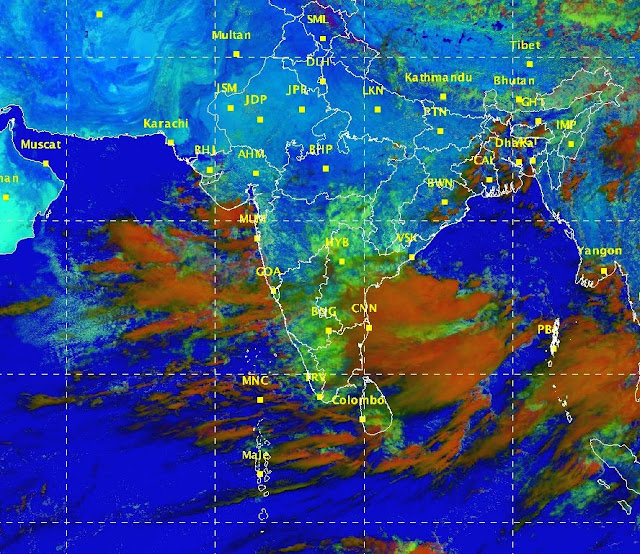
THIS SATELLITE IMAGE (JUNE 17, 2015, 0630 GMT) SHOWS THE MONSOON BUILDUP PRESENTLY

Share this PostPin ThisShare on TumblrShare on Google PlusEmail This

Mumbai, South Gujarat Stare At A Deluge, Floods On June 23, 2015

Major reliable computer forecast models are predicting very heavy rains in Mumbai and South Gujarat on June 23, 2015.


The reasons lie in the expected resurgence of the monsoons in the next 48 hours. We have talked about this in an earlier article.

As we said earlier the monsoons are really going to rev up, shorn of the Ashobaa baggage, in the next two days.

A start has been made with the increased  monsoon activity off the Andhra coast in the Bay of Bengal. A cyclonic circulation has already formed in the sea which is going to intensify into a low pressure area or a depression by June 20, 2015.

And in the Arabian Sea too things are going to happen in the next two days. A low pressure trough is taking shape presently. In the next few days this trough will become well marked and drift towards the Indian coast. By June 20-21, it might turn into a low pressure area.

About the Bay of Bengal expected system there is some disagreement as to its track. One forecast says it will move into Telangana, Chattisgarh, Madhya Pradesh and then swing north towards Uttar Pradesh. Another forecast predicts it will move west and reach western Maharashtra and Mumbai on June 23, 2015.

If this happens this Bay of Bengal system will collide headlong into the Arabian Sea low hovering near the Mumbai coast. The result? A deluge. Flooding rains in Mumbai and south Gujarat on June 23 onwards.

Even if the Bay of Bengal system moves to north India, very heavy rains are likely in Mumbai on June 23, 2015, as a result of the Arabian Sea low pressure area.

Anyway one looks at it, the conclusion is inescapable. 

Very heavy rains in Mumbai On June 23, 2015.

monsoon forecast heavy rainfall Mumbai June 23 2015
THIS FORECAST MAP SHOWS THE EXPECTED HEAVY RAINS IN MUMBAI ON JUNE 23, 2015

Share this PostPin ThisShare on TumblrShare on Google PlusEmail This

Indian Monsoons To Intensify Soon: Depression Off Andhra Coast On June 20, 2015


The monsoons are going to intensify rapidly in the coming few days with the formation of a depression in the Bay Of Bengal on June 20, 2015.


The intensification will be two pronged. The depression in the Bay of Bengal on June 20. And the formation of a low/cyclonic circulation in the Arabian Sea soon.

Let us discuss in details.

DEEP DEPRESSION OFF ANDHRA COAST JUNE 20, 2015

The low pressure area near the Andhra coast has already formed. It will intensify into a depression (May be a deep depression) by June 20.

It will move through Andhra, Chattisgarh and Madhya Pradesh in the following days.

Very to very heavy rainfall expected in these states after June 20, 2015.

The system will swing north into Rajasthan-western Uttar Pradesh on June 24, 2015.

HEAVY RAINS IN GUJARAT, SINDH LIKELY IN A WEEK

A low is expected to form in the Arabian Sea after June 20, 2015. It will start off as a trough off the Mumbai coast and then organize itself in  low around June 22.

This will further intensify into a depression and move through Gujarat and then enter Sindh in Pakistan.

Very heavy precipitation is expected in these area after June 22, 2015.

It is possible the system may not organize into a low but remain a upper air cyclonic circulation. But it will be a big rain maker.

Presently both major computer models are supporting heavy rains in western India after June 20. The GFS predicts a track of Saurashtra-Kutch-Sindh. The European model says it will move towards Mumbai-South Gujarat.

Image credit
Share this PostPin ThisShare on TumblrShare on Google PlusEmail This

MONSOONS TO REV UP FROM JUNE 16, 2015

Update June 13, 2015

A DEPRESSION LIKELY IN BAY OF BENGAL IN A FEW DAYS

After the Arabian Sea turned stormy and gave birth to tropical cyclone Ashobaa it is the turn of Bay of Bengal.

There is a distinct possibility that the bay may spawn a low in the next 72 hours which may turn into a deep depression within a day or two after that.

If this happens the monsoons will become active again. Ashobaa had drained away some of its enegy.

Heavy stormy rainfall seems to be coming Andhra's way as the depression is likely to form near its coast.

Hard to be certain as the monsoons are not giving clear indications where they will energize from.

We had talked about that yesterday.

Presently it appears the Andhra coast will be the next center of attraction.
++++++++±++
Indications are the south west monsoons will become active again from June 16 onwards. The reason being the formation of two low pressure areas, one each in tthe Arabian Sea and Bay of Bengal.

One of the lows will materialize near the Andhra coast and then move along the coast to Odisha and then enter West Bengal.

The Arabian Sea low may form around June 18. It may move into south Gujarat in a day or two after that.

In fact another low is expected in the Bay of Bengal on June 22, 2015. But ten days is a long time.
Share this PostPin ThisShare on TumblrShare on Google PlusEmail This

Cyclone Ashobaa Is Dissipating Fast

JTWC CONFIRMS DEMISE OF ASHOBAA AT SEA

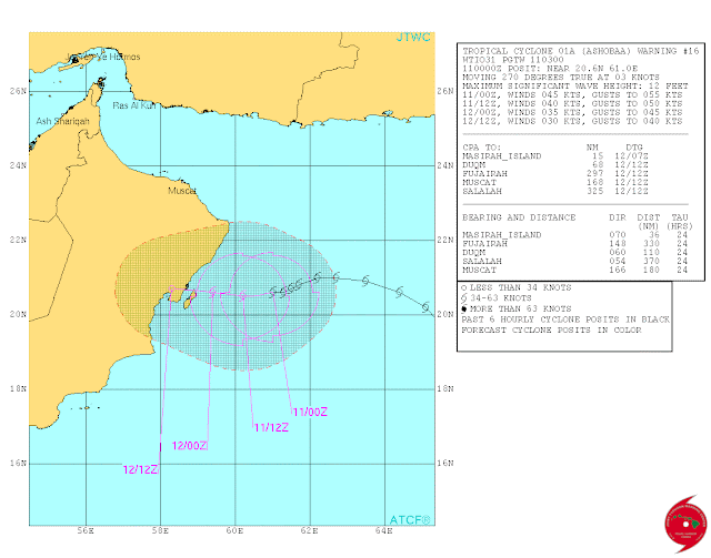
In its 0900 GMT June 11, 2015 bulletin the JTWC confirms the complete dissipation at aea of Ashobaa.

There may be some rainfall in the coastal areas of Oman near Masirah in the next 24 hours.


++++++++++

EXTRA UPDATE

DEATH OF A STORM

The 1300 GMT image today shows the disintegration of tropical cyclone Ashobaa. It is breaking up not weakening. It happened much sooner than was expected.

At present we are getting readings of winds of 55 km/ h. It is a depression now.  Not a tropical storm.

If it just dissipates even the rains in the coast of Oman will be much less than was forecast.

We have to wait for confirmation. Perhaps the ECMWF was right.


UPDATE

JTWC predicts Ashobaa will make landfall near Masirah late evening June 12, 2015, Friday night.

Expected winds are 60 km/h, gusts up to 80 km/h.

This information comes from the 0900 GMT bulletin today.

++++++++
Arabian Sea tropical cyclone Ashobaa is disintegrating rapidly. It will soon no longer be a tropical storm but a depression.

The JTWC in its latest bulletin issued at 0300 hours today, June 11, 2015, says the cyclone will be a deep depression when it makes landfall into Masirah, Oman.

Other forecast models suggest even quicker disintegration of the cyclone. They predict that at landfall Ashobaa will be a mere low pressure area.

The GFS foresees the low moving into central Oman bringing heat rains to the region.

Most of the effect of Ashobaa will be felt in the coastal region around Masirah. Heavy incessant rains and winds of 50 km/ h are expected in the area in the next 24 hours.

Some rains will extend to Sur. Muscat will remain unaffected.

The UAE will not see any " Ashobaa" effect.

The latest image taken at 0200  hours GMT today, June 11, 2015, shows that system has already weakened into a depression. And will weaken further rapidly.
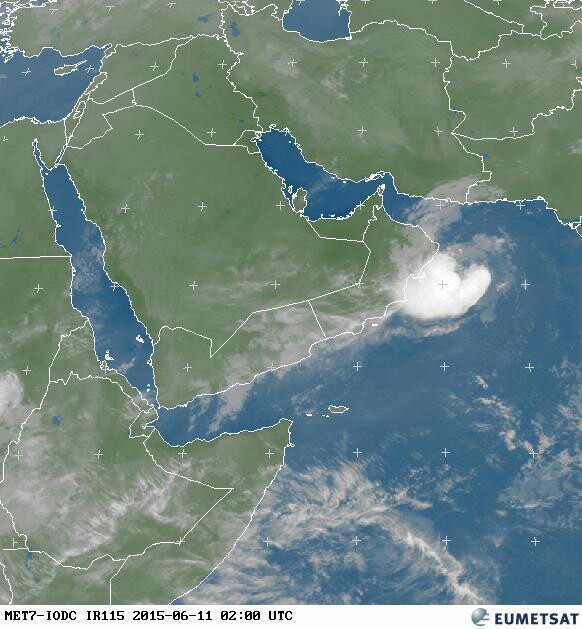
Cyclone ashobaa weakens depression June 15 oman
Ashobaa has weakened into a depression. Image at 0200 hours GMT June 11, 2015
Arabian sea cyclone Ashobaa track forecast
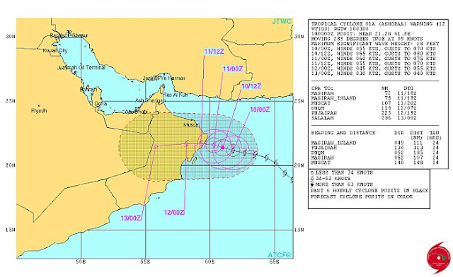
Latest JTWC track forecast issued at 0300 hours GMT June 11, 2015

Share this PostPin ThisShare on TumblrShare on Google PlusEmail This

Another Arabian Sea Storm By June 18, 2015?

Weather forecast models are indicating the formation of another storm in the Arabian Sea within a week, that is by June 18, 2015.

These models say the depression will form off the coast of Maharashtra on June 17, 2015. It is unclear whether it will intensify into a deep depression or a tropical storm.

The European computer model ECMWF hints at a tropical cyclone near the Gujarat coast on June 19, 2015.

It is too early to say anything with conviction. We can only say that computer models are hinting at another storm in a week in the Arabian Sea this June 2015.

WE HAVE A VALID REASON......

 We make the above prediction after looking at the 850 mb wind maps of the GFS and ECMWF of that forecast period.

 There is near similarity between the two. Only difference is the GFS predicts a low in Konkan south of Mumbai. The European model predicts the low developing further north.

 The strong monsoon current will extend from the African coast near Somalia.

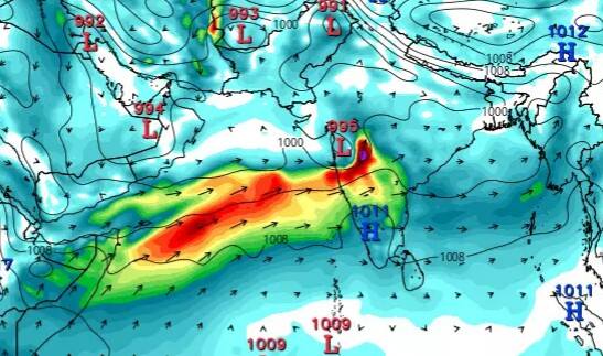
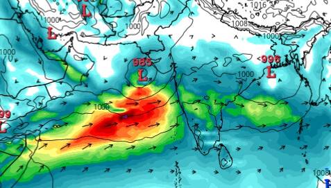
 The first map below is the GFS forecast of June 21. The second is the ECMWF forecast of June 20, 2015.

 This system will reinforce monsoons in western and northwestern India.

arabian sea storm forecast june 2015
GFS FORECAST MAP JUNE 21, 2015

arabian sea low pressure june 20 2015
THE EUROPEAN MODEL FORECAST MAP SHOWING THE SITUATION ON JUNE 20, 2015

Share this PostPin ThisShare on TumblrShare on Google PlusEmail This

Weakened Tropical Cyclone Ashobaa Will Enter Oman Tomorrow Night

Cyclone Ashobaa is weakening. It will enter northeastern Oman in the Al Sharqiyah Region near Masirah Island tomorrow late night. That is the night of June 11, 2015. The towns of Hayy and Dawwah will be most affected.

It will dissipate quickly and move inland into central Oman in the Al Dakhiliyah region bringing it some rains.

Sur will get heavy rains. Muscat will receive only a drizzle.

If the storm moves inland after dissipating as a low very heavy rains are expected in coastal areas around the town of Hayy.

It is also possible that the storm might make landfall in the morning of June 12, 2015.

Since the cyclone is weakening, only winds of 55-65 km/h will be felt in the coastal areas of the country. That is the area which will receive the most rains.

It is also not certain if the cyclone will make landfall into Oman at all. The reliable European computer forecast model ECMWF, predicts a demise mid sea near the coast of the country.

cyclone ashobaa track forecast
IT IS EXPECTED THAT CYCLONE ASHOBAA WILL WEAKEN INTO A DEEP DEPRESSION BY THE TIME IT MAKES LANDFALL INTO OMAN. BUT THE JTWC IS BULLISH. IT EXPECTS WINDS OF 100 KM/H ON IMPACT. IT IS DOUBTFUL IF THE CYCLONE WILL ENTER OMAN AT ALL OR NOT.

Share this PostPin ThisShare on TumblrShare on Google PlusEmail This

Expected Arabian Sea Tropical Storm (Ashobaa?): Ramifications For Indian Monsoons

Reliable international forecast models are predicting the formation of a tropical cyclone in the Arabian Sea within days. The initial low pressure area will form tomorrow in south east Arabian Sea tomorrow which will intensify into a cyclone (Ashobaa) or a deep depression on June 6, 2015.

Whatever form the storm takes, the question arises what influence will it have on the presently gloomy picture of the Indian monsoons 2015?

The answer mainly lies on the path/track of the storm. Gujarat? Pakistan? Or Oman (May be south-eastern Iran too).

Wherever the storm goes the region is going to get a deluge when we talk of rainfall (Disregarding the harm caused by the winds).

If it goes to Pakistan it is going to relieve greatly the water situation in Sindh and Balochistan. Of course Oman too would welcome rains.

If it turns towards Gujarat and then moves inland through Rajasthan and then onto Haryana and Delhi it will be like God smiling on the farmers of these dry areas. Storms like these dump inches of water in a day and would greatly relieve the agricultural woes of north western India.

If the storm does not come to India, it will suck up all the water vapor and energy of the monsoons and dump it some where else.

But who are we to decide? Nature and Mother Earth will do as she sees fit.

The  track of the impending storm will become clearer by June 6, 2015 when the accurate and venerable JTWC (And our own esteemed IMD) will come out with their predictions.

We wait in anticipation. A storm in a year expected to be a drought year would be most welcome.

Related: Latest Forecasts For Future Cyclone ASHOBAA

satellite image arabian sea cyclone ashobaa june 2015
THE GATHERING STORM: SATELLITE IMAGE OF SOUTH ASIA (1200 HOURS GMT TODAY) SHOWS THE BIRTH OF A TROPICAL STORM

Share this PostPin ThisShare on TumblrShare on Google PlusEmail This

Latest Forecasts/Updates


Popular Posts

Search This Site