Imminent Arabian Sea 'Low' Will Propel Monsoons

On the monsoon front the news are disheartening. Monsoon 2015 has left top meteorological agencies perplexed and professional weather forecasters have gone into a shell.

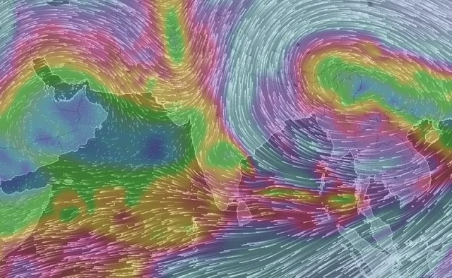
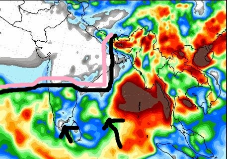
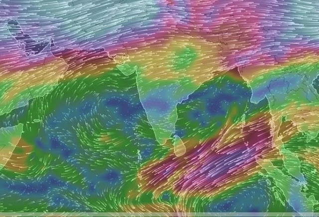
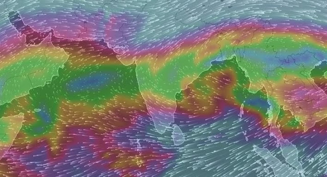
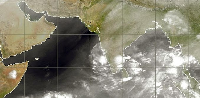
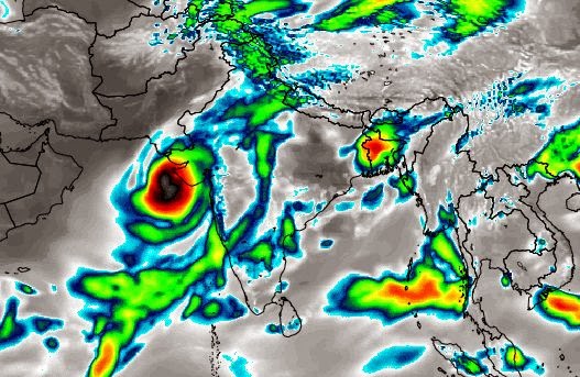
Things may change soon. Forecast models predict a low pressure area forming in the east central Arabian Sea on around June 5-6, 2015. This low pressure area or depression (Some models also say may be a cyclone) will rejuvenate the monsoon rains.

Increased rainfall is expected in Kerala and Karnataka from June 3, 2015, which will further intensify with the formation of the aforementioned low. If that low does occur, the rains may reach Maharashtra coast within days after that.

It all depends on where the low decides to go. If it sticks close to the Indian west coast, then the rains will reach Mumbai by June 10. Otherwise the rains will go to Gujarat or Sindh (Some say even Oman). SEE XWF-WEATHER INDICATIONS

Looks like we have very wet stormy weather ahead after June 5, 2015. It all depends on the Arabian Sea 'low'.

Read Arabian Sea Storm Possibilities And Latest Updates
==========================================
RAINFALL FORECAST FOR INDIA TILL JUNE 5, 2015

In the next three days the rains will be active mainly in Tamil Nadu. Very heavy rainfall is forecast for the entire state in the next 48 hours.

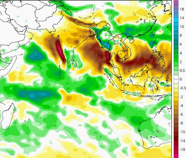
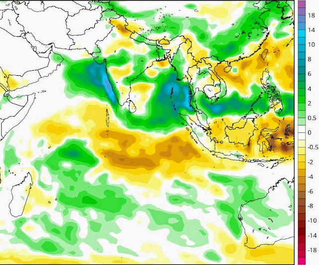
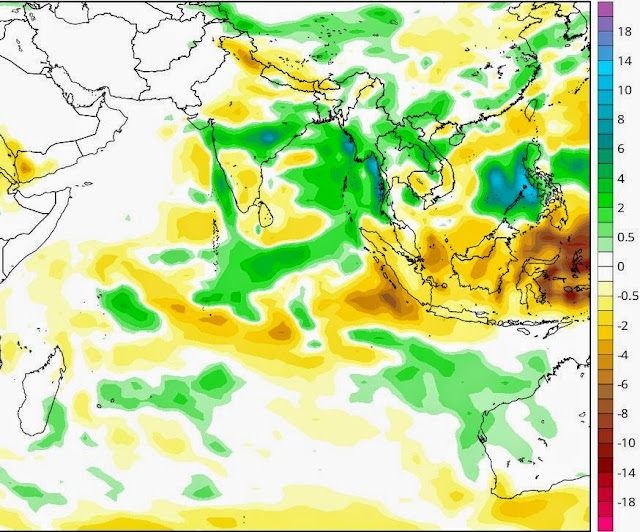
After June 3, 2015, the rains will gradually move westwards towards Karnataka coast. The formation of a low pressure area off the coast on June 5, 2015 will lead to heavy precipitation in coastal Karnataka from June 5, 2015. The rain will spread to southern Maharashtra coast and the entire west coast of Indian by June 6.

So we see a rejuvenation of monsoons from June 4.
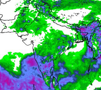
monsoon rainfall forecast june 6, 2015
THE MAP SHOWS TOTAL RAINFALL FROM JUNE 1 TO JUNE 6, 2015. THE MONSOONS WILL PICK UP IN A DAY OR TWO.


Share this PostPin ThisShare on TumblrShare on Google PlusEmail This

Weather Forecasting Is A Dicey Thing


Before examining why longer-term forecasts are less accurate than current forecasts, we look at basic definitions on the types of weather forecasts made in relation to time:

 A short-range forecast is a weather forecast made for a time period up to 48 hours.

Extended forecasts are for a period extending beyond three or more days (eg. a three to five-day period) from the day of issuance.

Medium range forecasts are for a period extending from about three days to seven days in advance.

Long-range forecasts are for a period greater than seven days in advance but there are no absolute limits to the period.

Short-range forecast predictions, where the forecast is made for a time period for today and/or tomorrow (up to 48 hours), are generally more accurate than the other types of forecasts. Weather forecasts still have their limitations despite the use of modern technology and improved techniques to predict the weather.

 For example, weather forecasts for today or tomorrow are likely to be more dependable than predictions about the weather about two weeks from now. Some sources state that weather forecast accuracy falls significantly beyond about 10 days. Weather forecasting is complex and not always accurate, especially for days further in the future, because the weather can be chaotic and unpredictable.

For example, rain or snow cannot always be predicted with a simple yes or no. Moreover, the Earth’s atmosphere is a complicated system that is affected by many factors and can react in different ways. Weather observation techniques have improved and there have been technological advancements in predicting the weather in recent times.

On average, a five-day weather forecast of today is as reliable as a two-day weather forecast 20 years ago. Despite this major scientific and technical progress, many challenges remain regarding long-term weather predictability.

xtreme weather forecast for laymen XWF WEATHER


 THE AMERICAN NATIONAL WEATHER SERVICE

 “We sustain higher accuracy out to two to three days in advance; then it starts dropping off faster at days six through eight,” says Louis Uccellini, director of the National Weather Service.

 That’s why the National Weather Service makes specific weather forecasts — high and low temperature and probability of precipitation — only seven days in advance.

 For extreme weather events such as hurricanes and cyclones, the agency sometimes makes longer-term predictions, based on such things as movements of the Madden-Julian Oscillation (a cycle of atmospheric weather in the Indian Ocean and the western Pacific) or the more famous El Nino weather pattern.

The Weather Service also offer a 10-month forecast, but it’s extremely vague, making such predictions as an above-average amount of precipitation over the course of a season. Making specific predictions that far ahead isn’t yet possible, and it may never be, according to Uccellini. He notes that three obstacles prevent scientists from making reliable forecasts even only 10 days in advance: observation systems, numerical models and computing power.

 With weather satellites proliferating, there have been tremendous improvements in global data collection over the last decade or so. Computing power has also moved forward rapidly, although the ability to run computations that divide the world into small segments demands a staggering electronic infrastructure.

The models are the real sticking point, but the National Weather Service is making progress by taking a sort of “poll of polls” strategy, to borrow a phrase from political scientists. “We’re now finding that if you run an ensemble of models, merging an envelope of solutions from second and third models, you can extract a more likely solution,” Uccellini says. 

Testing on this combined-model approach has suggested that the National Weather Service may be able to push its official forecast out to 10 days, but no decision to do that has been made. (The agency moved from a five-day forecast to a seven-day one only in 2000.)

Sources:
1. Time and date
2. Washington Post
Image 1 source
Image 2 source
Share this PostPin ThisShare on TumblrShare on Google PlusEmail This

Dismal Monsoon Rainfall Expected Till June 22, 2015

IMD's grim picture for monsoon 2015 seems to be coming true. Looks like the villain El Nino is going to spoil the rains in the Indian sub-continent, at least for the next one month, till June 22, 2015.

The CFS Model, the long range climate forecast model designed by NOAA in its predictions for the coming four weeks paints a grim picture of deficient rainfall, in almost all parts of India.

Overall the rains till June 22 are going to be below average in almost all areas of India, except for some pockets of North East, Tamil Nadu, Kerala and Karnataka.

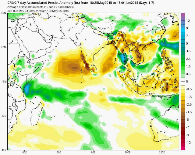
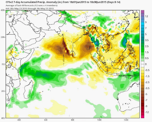
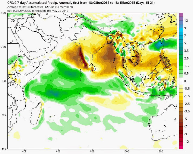
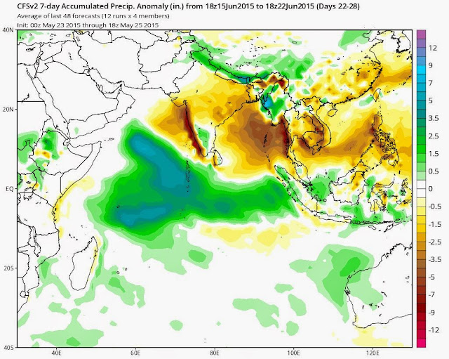
Given below are rainfall forecast maps for the coming four weeks, starting from May 25, 2015.

Please note that the CFS forecasts are issued every day. What we say now is the basic trend that we have discerned after monitoring the data for the last one week. We shall keep you informed of future trends of the rainfall possibility as envisaged by the Climate Forecast Model.

Click here for CFS Monthly Forecasts (June to September 2015)

WEEK 1 (May 25 to June 1)

The worst affected will be coastal areas along the Arabian Sea. The rain deficiency will be as high as 4 inches in some areas.

monsoon rainfall forecast india may 25 to june 1
MAY 25 TO JUNE 1: KERALA WILL HAVE RAINS 4-5 INCHES BELOW NORMAL. ONLY PARTS OF ASSAM, NORTH BENGAL AND NORTHERN BANGLADESH WILL HAVE SURPLUS PRECIPITATION.

WEEK 2: JUNE 1 TO JUNE 8

monsoon 2015 rainfall forecast weekly june 1 to june 8
JUNE 1 TO JUNE 8: THE RAIN DEFICIENCY ON INDIAN WEST COAST MAY BE AS HIGH AS 6-7 INCHES. EVEN THE NORTH EASTERN STATES WILL RECEIVE RAINS 5-6 INCHES BELOW NORMAL.
JUNE 8 TO JUNE 15, 2015

monsoon weekly rainfall forecast june 8 to june 15
JUNE 8 TO JUNE 15: THE HORROR STORY CONTINUES INTO THE THIRD WEEK. RAINS IN KERALA AND INDIAN WEST COASTAL AREAS WILL BE BELOW AVERAGE BY ALMOST 10 INCHES. ONLY CERTAIN POCKETS IN KARNATAKA WILL HAVE SURPLUS RAINS (ABOUT 2 INCHES)
JUNE 15 TO JUNE 22, 2015
monsoon 2015 rain forecast june 15 to june 22
JUNE 15 TO JUNE 22: A LOW PRESSURE IN THE ARABIAN SEA WILL DUMP PRECIOUS COPIOUS RAIN INTO THE SEA. RAINS DEFICIENT IN INDIAN WEST COAST, ODISHA, ANDHRA AND WEST BENGAL. ABOVE AVERAGE RAINS ONLY IN PARTS OF KARNATAKA, TAMIL NADU AND IN MANIPUR, TRIPURA, MEGHALAYA AND MIZORAM

Share this PostPin ThisShare on TumblrShare on Google PlusEmail This

Monsoon Forecast By Another Indian Government Agency (CMMACS) Predicts A Brighter Monsoon 2015 Picture

In India, the Indian Meteorological Department is not the only government agency which gives monsoon forecasts. It is CMMACS (CSIR Centre For Mathematical Modelling And Simulation), now called CSIR Fourth Paradigm Institute.

This agency has predicted that the monsoons will hit hit Kerala on May 25, 2015 (Quite near our prediction of May 23). The initial wave will be weak followed by a stronger wave on June 11, 2015.

Its forecasts are

Probabilities for excess, normal and deficit rainfall over different regions and months
June-August, 2015
Region Probability(%)
                          Excess Normal Drought
All India                   20      50      30
North-India              10      20      70
South India              30      60      10
Central India            20      70      10
North-east India       20      70      10
North-west India      10      70      20

So according to it all India there is 50% chance of a normal monsoon, 20% probability of a excess rainfall and only 30% chance of a drought in 2015. It also agrees with what we have said in an article today, that northern India will receive scanty rainfall this monsoon.
Share this PostPin ThisShare on TumblrShare on Google PlusEmail This

Monsoon 2015 Update: Weak June, Good July Rainfall Expected

NOAAs CFS (Climate Forecast System) predicts poor monsoon rainfall in June in the Indian subcontinent. July and August will bring good rains.

The monsoons are knocking at Kerala's doors. But the Arabian Sea branch of the monsoon is likely to remain weak in the coming days.

The IMD considers a certain amount of rainfall to declare the onset of monsoon. That is why it says it will come to Kerala around May 30. Because around that time considerable rainfall is forecasted for the state.

If we do not take the rains into account, monsoons have already reached the state. The monsoons winds reaching up to 14 kilometers in the atmosphere are already in place. They have already reached Kerala, Tamil Nadu, southern Andhra and Karnataka.

But the Arabian Sea monsoons will remain weak in the coming 10 days. It is not likely to move north in the coming days. In contrast the Bay of Bengal monsoon stream is vigorous and will move north into West Bengal and Bihar around June 4, 2015.

monsoon 2015 update latest forecast
SCENARIO ON JUNE 4, 2015. THE MAP SHOWS  A VIGOROUS  BAY OF BENGAL MONSOON STREAM. THE ACTIVITY OVER ARABIAN SEA IS FEEBLE.
CFS MONTHLY MONSOON FORECAST

The American NOAA (National Oceanic and Atmospheric Administration) forecasts poor monsoon rains in June for India. July and August are likely to be above average rain fall months.

Given below are rainfall forecast maps for June-September. Please note the maps show the anomaly (below average, above average) in inches for each month.

One fact stands out very clearly. Average or below average rainfall is expected in north Indian states (Uttar Pradesh, Punjab, Haryana) and Rajasthan this monsoon.

The CFS forecasts are seasonal long range forecasts. They give a good indication of the trends. We will keep you informed of any changes in the CFS forecast for monsoon 2015.

monsoon rainfall forecast june 2015
THE FORECAST FOR JUNE 2015 VERY POOR RAINS ON THE ARABIAN SEA COASTAL AREAS AND MANY OTHER STATES. ABOVE AVERAGE RAINS ARE LIKELY ONLY IN NORTH EASTERN INDIA, PARTS OF BANGLADESH, TAMIL NADU AND PARTS OF KERALA AND SOUTHERN ANDHRA.


indian monsoon forecast july 2015
JULY WILL BE BETTER WITH ABOVE AVERAGE RAINS IN GUJARAT, MADHYA PRADESH, MAHARASHRA, ANDHRA, ODISHA, WEST BENGAL, BANGLADESH AND PARTS OF BIHAR.


MONSOON RAINFALL FORECAST AUGUST 2015 INDIA
AUGUST WILL BRING GOOD RAINS TO SAURASHTRA, MAHARASHTRA, ODISHA, ANDHRA, JHARKHAND, WEST BENGAL.


INDIA MONSOON RAINFALL FORECAST SEPTEMBER 2015
SEPTEMBER WILL SEE ABOVE AVERAGE RAINS ONLY IN PARTS ODISHA, MADHYA PRADESH AND NORTH EAST INDIAN STATES
JMA (JAPAN METEOROLOGICAL AGENCY) SEASONAL FORECAST PAINTS DISMAL MONSOON 2015 PICTURE

The JMA in its three month forecast issued in May predicts a very gloomy picture for Indian monsoons in 2015. It says in June-July-August rainfall is going to below normal in almost all of India, except for the states of Odisha, West Bengal and northern Andhra where there will be slightly above average rainfall. SEE FORECAST MAP BELOW

INDIAN MONSOON 2015  RAINFALL FORECAST
THREE MONTH RAINFALL FORECAST (JUNE-JULY-AUGUST)  MONSOON 2015. JMA PREDICTS BELOW AVERAGE RAINS IN ALMOST ALL OF INDIA

Share this PostPin ThisShare on TumblrShare on Google PlusEmail This

India Weather Update: May 21, 2015: Bay Of Bengal Monsoon Stream Expected Stronger Than Arabian Sea

The Bay of Bengal is now the powerhouse sustaining the monsoon winds. An upper air cyclonic circulation in central the Bay is bringing floods to Maynmar now.

The circulation will continue in the coming days and will shift westward bringing the monsoons to the Indian east coast by June 5, 2015. As a result central Bay of Bengal is going to see a deluge in the coming week which will drench the Andaman Islands.

By the first week of June, rainfall activity over the coastal states will increase. In Tamil Nadu, Andhra and Odisha.

The Arabian Sea branch of the monsoons has petered out after bringing heavy rains to Kerala and Karnataka. It is expected to strengthen by June 5 and rainfall activity will increase. Kerala and Karnataka will be covered by the monsoons by that time. But Mumbai will have to wait. The Arabian Sea branch will not be as vigorous as the Bay of Bengal branch of the monsoon in the coming 15 days.

By June 6, 2015, the monsoons will have covered Kerala, Karnataka, Tamil Nadu, parts of Andhra, Indian North Eastern States, and Bangladesh.

PROGRESS OF MONSOON BY JUNE 6, 2015
EXPECTED PROGRESS OF MONSOON BY JUNE 6, 2015

Share this PostPin ThisShare on TumblrShare on Google PlusEmail This

EQUINOO Will Bring A Good 2015 Monsoon For India?


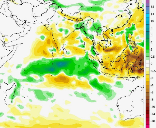
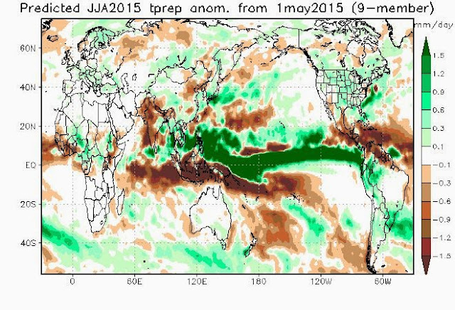
NOAA has said that there is a 90% chance of El Nino staying late summer, 80% chance that this unwanted guest would linger on throughout 2015. We all know El Nino is a bad guy who adversely affects the Indian Monsoons.

Well that was the bad news.

The good news? EQUINOO. You might say what on earth is that?

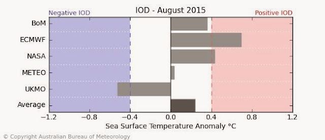
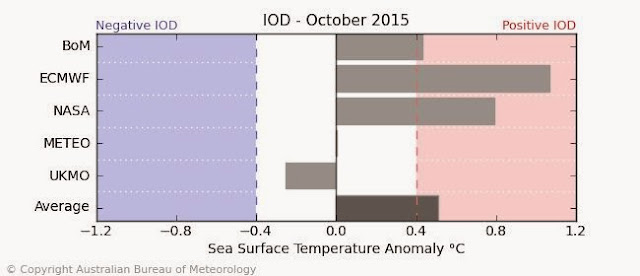
The full form is Equatorial Indian Ocean Oscillation. The so-called Indian Ocean Dipole (IOD). What is it?

It is a phenomenon that influences the Indian monsoon. It involves the Indian Ocean waters near the coast of Somalia and also near Indonesia. If the Somalian waters are warmer and stormier than the Indonesian waters then it is called a Positive IOD.

EQUINOO IOD INDIAN OCEAN DIPOLE
THE INDIAN OCEAN DIPOLE (IOD)

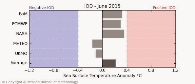
A positive IOD is good news for the Indian monsoons. And it is positive now. The coast near Somalia has been stormy for quite many days and it is likely to stay that way for many more days. (SEE FORECAST CHARTS BELOW)

So a bad El Nino might be nullified by a positive IOD and we will get a bumper monsoon.

Below are the Indian Ocean Dipole forecast charts for June, August and October 2015. They are expected to be most positive in October. Heavy rains then?

IOD FORECAST INDIAN OCEAN DIPOLE FORECAST 2015 JUNE


IOD FORECAST INDIAN OCEAN DIPOLE AUGUST 2015


IOD FORECAST OCTOBER 2015 INDIAN OCEAN DIPOLE

Share this PostPin ThisShare on TumblrShare on Google PlusEmail This

Galloping Indian Monsoon May Hit Kerala In Days

UPDATE: MAY 19, 2015

We stand by our earlier forecast of monsoons hitting Kerala by May 23-24. But after that the monsoon winds will suddenly lose steam. By June 1, 2015, they will have reached southern Maharashtra, after covering Kerala and Karnataka. Mumbai will have to wait.

On the Bay of Bengal branch of the monsoon, by June 1, the entire Indian north-eastern states, Bangladesh and parts of West Bengal, Odisha, Andhra will be covered.

+++++++++++++++++++++++++++++++++++++++

 The South West Monsoon this year seems to be galloping. Two days back it entered the Andaman and Nicobar Islands. And if forecasts are to be believed it will hit Kerala by May 23, 2015. It is already nudging southern Sri Lanka.

Please note that we are NOT taking into consideration the parameters that the Indian Meteorological Department uses. The IMD uses a subjective method described in this article. (Further information can be had in this article by Indian Institute Of Tropical Meteorology).We base our prediction on the upper air winds (above 12 kilometers). Monsoons is just not rains and dark clouds. The monsoon system extends high in the atmosphere. When the direction of these high air winds change on a long range basis, we can say with surety that monsoons are coming.

Seeing these high air winds, we see them reaching Kerala on around May 23, Mumbai by May 29 and the Indian north east and eastern Indian by the end of the month. Way before the normal onset of monsoons. We see the monsoons touching eastern Gujarat by June 2, 2015!

south west indian monsoon progress 2015
MONSOON TODAY NOW. REACHED ANDAMAN AND NICOBAR ISLANDS, TOUCHING SOUTHERN SRI LANKA

indian monsoon progress 2015 kerala
MAY 23, 2015. MONSOONS HIT KERALA
.
Share this PostPin ThisShare on TumblrShare on Google PlusEmail This

Bay Of Bengal To Turn Very Stormy In End of May 2015

VERY STORMY BAY OF BENGAL IN THE COMING DAYS 


 As the stormy weather near the Kerala coast in the Arabian Sea gradually peters out, the Bay of Bengal is going to turn very stormy in the next ten days, starting from May 18, 2015. I guess the monsoons are gaining momentum in the Bay of Bengal. Just short of a tropical cyclone.

 Till May 26-27, the entire Bay of Bengal is going to turn very rough with 40-50 kph winds and waves. The Indian east coast will receive a lot of rainfall in the coming days, starting with Tamil Nadu, then coastal Odisha, West Bengal and Bangladesh eventually. But the heaviest rains are going to occur in Myanmar. Expect flooding in the country around May 25, 2015.

 See the rain forecast map for the coming 15 days for South Asia below.

15 days rainfall forecast map south asia

Share this PostPin ThisShare on TumblrShare on Google PlusEmail This

Tropical Cyclone Chances In North Indian Ocean (Arabian Sea, Bay of Bengal) Uncertain

The chance of a tropical cyclone developing in the North Indian Ocean has receded according to latest forecasts from various models.


A cyclone or not? In the North Indian Ocean. That is the question now.

In the last few days the GFS Model had been gung-ho  about the prospect of an Arabian Sea cyclone. The Canadian CMC had supported while the European Model (ECMWF) had disagreed going so far as to say that the storm would form in the Bay of Bengal.

Come today and all the forecast models are showing flat storm less  forecasts for the North Indian Ocean. The GFS says no cyclone. The CMC says no cyclone. The ECMWF says no cyclone.

What has happened? Has the ocean turned docile? Some meteorologists say the over-active Pacific Ocean is hurling one typhoon after another (Noul, then Dolphin) and sucking off the moisture from the Indian Ocean. Going by this reasoning will the North Indian Ocean become active storm-wise after the demise of super typhoon Dolphin in a week's time? Time will tell.

In the mean time we will closely monitor the Indian Ocean and keep you updated on any incipient tropical cyclone.

Now is the time. Now is the season. Hope the Indian Ocean does not disappoint.

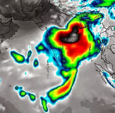
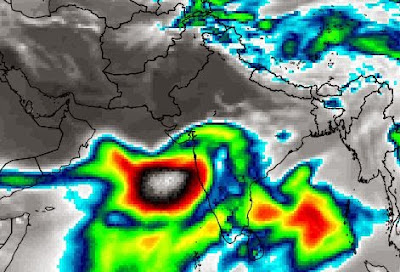
SATELLITE IMAGE NORTH INDIAN OCEAN MAY 2015
WATER VAPOR SATELLITE IMAGE OF THE NORTH INDIAN OCEAN AT 0300 HRS GMT TODAY. WILL IT SPAWN A STORM?

Share this PostPin ThisShare on TumblrShare on Google PlusEmail This

Massive Tropical Cyclone (Ashobaa) To Hit Gujarat May 21, 2015?

LATEST UPDATE MAY 16, 2015

There is no possibility of a tropical cyclone developing in either the Arabian Sea or Bay of Bengal in the coming next few days. Please read our latest forecasts and do not go by earlier articles.
+++++++++++++++++++++++++++


 It is possible that a powerful cyclone (Ashobaa) may soon form in the Arabian Sea in North Indian Ocean, which will intensify and make landfall into Gujarat state of Western India on May 21, 2015.

At presently only the reliable American GFS forecast system predicts this storm but we have seen from experience that generally GFS forecasts are accurate. We shall closely monitor the situation and keep you updated with latest forecasts as soon as we come across them.

According to the GFS, the cyclone will start off as a low pressure area on May 17, near the Karnataka-Kerala coast and then move north and intensify into a tropical cyclone (Ashobaa). The storm is likely to hit Gujarat on May 21, 2015.

We will monitor future GFS forecasts and see if the cyclone formation is sustained. We shall also observe the European Forecast Model and see whether it supports the GFS prediction.

The situation being fluid, we have to wait and see if the cyclone forms and what its track turns out to be. Gujarat, Pakistan or Oman?

Keep in touch for latest updates.

tropical cyclone ashobaa arabian sea gujarat may 2015
FORECAST MA SHOWING ARABIAN SEA CYCLONE ASHOBAA HITTING GUJARAT ON MAY 21, 2015

Share this PostPin ThisShare on TumblrShare on Google PlusEmail This

Super Typhoon Dolphin No Threat To Philippines

UPDATE MAY 16, 2015: DOLPHIN A SUPER TYPHOON NOW

Typhoon Dolphin in a few hours will turn into a howling super typhoon with winds of a staggering 275-330 kph! Just yesterday it seemed it would mature at most into a category 4 hurricane, but favourable conditions will enable it to join the league of Haiyan, Kammuri, Vongfong, Hagupit and the recent Maysak. All in the West Pacific Ocean.

Luckily it has already departed from Guam and its track suggests it will not hit mainland Japan. It will swing north away from the Philippines. So except for small non-decrepit island in the Pacific, humans are safe from Dolphin's fury.

The Pacific Ocean seems to have turned into a factory manufacturing super storms. Something to think about.


++++++++++++++++++++++++++++++++++

TYPHOON DOLPHIN NEARING GUAM NOW. UPDATE: MAY 15, 2015

 Powerful typhoon Dolphin is nearing Guam now. Contrary to earlier predictions it will not turn out to be a super typhoon but Guam can expect sustained winds of 150+ kph. The good news for the island is the storm will pass slightly north of it , not a direct hit.

TYPHOON DOLPHIN MAY 2015 GUAM


++++++++++++++++++++++++++

TYPHOON DOLPHIN UPDATE MAY 14, 2015

Typhoon Dolphin is on its way to becoming a super typhoon. The JTWC predicts that by May 18, 2015, it will turn into a howling monster with winds of 240+ kph.

Luckily for Guam Dolphin will turn into a super typhoon 3 days after it passes through the island. Guam is in for a direct hit on Friday evening (Local time) with wind speeds of 200+ kph, gusts up to 240 kph.

Philippines will remain safe from typhoon Dolphin as after passing Guam it will swing north. It is at that stage it will reach super typhoon status.

Japan will not be affected by the typhoon as it will continue curving away from the mainland. The Japanese historical island of Iwo Jima is for a direct hit with winds of 230 kph on May 19, 2015

One wonders why the Pacific Ocean is churning out super typhoons by the fistful whereas the Atlantic Ocean has become relatively docile. An interesting topic for weather scientists and climatologists.

Some meteorologists believe an over active Pacific Ocean is stifling cyclone development in the North Indian Ocean.

latest track forecast typhoon dolphin
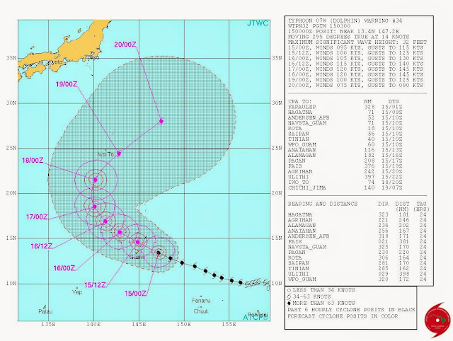
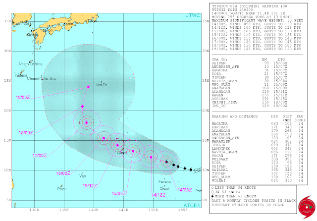
LATEST TRACK FORECAST (0300 GMT MAY 14, 2015) FOR TYPHOON DOLPHIN


++++++++++++++++++++++++++++++++++

 Another powerful typhoon is brewing in the Western Pacific Ocean after Noul is fading into oblivion. Typhoon Dolphin has already formed and is intensifying all the time.

Dolphin will be as powerful as Noul was. But the good news for Philippines is that it is not going to hit it.

Guam is not going to be so lucky. Typhoon Dolphin will hit it directly on May 15, 2015 with sustained winds of 150 kph.

After that typhoon Dolphin will swing north, away from Philippines. It is not expected to affect Japan either.

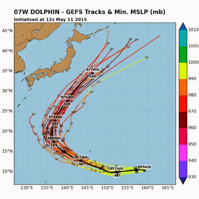
typhoon dolphin track gfs ensemble
TRACK FORECAST FOR TYPHOON DOLPHIN ACCORDING TO THE GFS ENSEMBLE MODEL


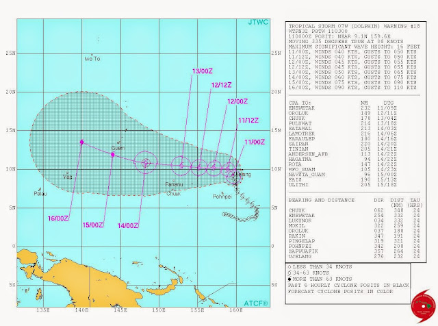
TYPHOON DOLPHIN TRACK FORECAST MAY 2015
TRACK FORECAST OF TYPHOON DOLPHIN BY JTWC

Share this PostPin ThisShare on TumblrShare on Google PlusEmail This

North Indian Ocean (Arabian Sea, Bay Of Bengal) To Spawn A Cyclone By May End

UPDATE: MAY 11, 2015 
The situation is confusing and volatile. The GFS forecast today denies any possible cyclone. The NAVGEM Model says a storm will form on May 13, 2015 near the Sri Lanka coast, rapidly intensify into a cyclone and hit the Andhra coast in India on May 16. The Canadian CMC Model agrees. The GFS predicts only a low pressure area. Not very reliable.

We will close watch and keep you updated. Meanwhile you can watch and monitor North Indian Ocean (Arabian Sea, Bay of Bengal) yourselves at this link on our STORM TRACKER

+++++++++++++++++++++++++++

 Forecast models are throwing out confusing forecasts of a tropical cyclone developing in the North Indian Ocean (Arabian Sea, Bay Of Bengal) by the end of May, 2015.

The cyclone is likely to develop around May 20-25. Where? That is not certain.

There are two possible scenarios.

First scenario is the storm develops in the Bay of Bengal of the coast of Tamil Nadu around May 20. The storm then intensifies and moves north and hits the Odisha-West Bengal coast by May 25, 2015. This may be a powerful cyclone with acentral minimum pressure of around 975 Mb.

cyclone ashobaa bay of bengal may 2015
SCENARIO 1: MAY 25. CYCLONE ASHOBAA HITS ODISHA-WEST-BENGAL COAST
Second scenario is the cyclone forms of the coast of Kerala on May 20, then moves slowly northwards along the Indian west coast and makes landfall into Gujarat on May 26, 2015.

arabian sea tropical cyclone may 2015
SCENARIO 2: MAY 26. CYCLONE ASHOBAA HEADS TOWARDS GUJARAT
There are still 10-15 days to go so stating anything with certainty is well nigh impossible but it appears the North Indian Ocean is pregnant with possibilities of a tropical cyclone developing around May 20, 2015.

The time is ripe. The ocean waters are well heated to power and feed a cyclone. And May-June is the time that the Bay of Bengal and Arabian Sea throw out a cyclone or two.

Keep in touch for updates and for latest forecasts.
Share this PostPin ThisShare on TumblrShare on Google PlusEmail This

Typhoon Noul (Dodong) Update: Will Hit Santa Ana In Luzon Sunday Night

Update: 1230 Hours GMT, May 9, 2015

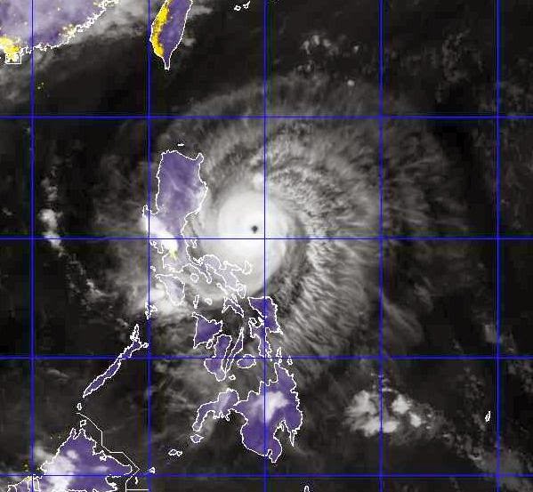
Typhoon Noul (Dodong) is only going to make a brief landfall at Santa Ana, Cagayan Valley, the northern most tip of Luzon, Philippines on Sunday late evening (Local Time).

Presently the storm is whipping 150 kph winds gusts up to 180 kph. It is about 400 kilometers from Santa Ana, Cagayan Valley, Luzon, Philippines to where it is headed.

At landfall it will weaken a little. Winds will drop to 110 kph.

The adjoining islands of Palau, Batan and Babuyan will bear the brunt of the storm.

Very heavy rainfall is expected in these places. Cagayan Valley will see floods and there is extreme danger of landslides as torrential rains will fall there.

Taiwan is safe from typhoon Noul. It will pass a few hundred kilometers from the eastern coast of the country. Not much effect.


typhoon noul dodong 2015
1130 GMT, MAY 9, 2015. LATEST IMAGE OF TYPHOON NOUL

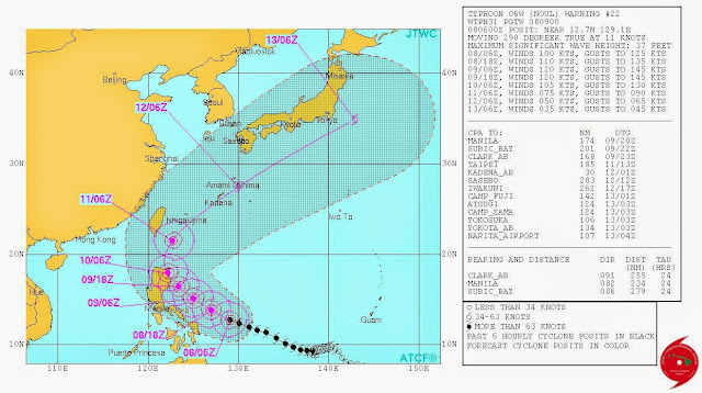
LATEST TRACK FORECAST FOR TYPHOON NOUL DODONG BY JTWC ISSUED TODAY

Share this PostPin ThisShare on TumblrShare on Google PlusEmail This

Typhoon Noul To Hit Cagayan Valley, Luzon, Philippines Sunday (May10, 2015) Afternoon

Ground Zero is going to be Cagayan Valley, Luzon, northern Philippines. That is where typhoon Noul (Dodong) is going to enter the country. When? May 10, 2015. Sunday afternoon, Philippines Time. Wind speed at impact? 120 kph, gusts up to 150 kph.

But the country will get a taste of the typhoon tomorrow (Saturday) itself as the periphery of the storm will lash Catanduanes Island. Luckily for the island it will not be a direct impact so the full fury of the storm will not be felt. But expects strong winds and heavy showers.

Eastern coast of Luzon near the Cagayan Valley will not be so lucky as it will face the brunt of this tropical cyclone. Very heavy rains are expected in the northern half of Luzon. Manila will escape relatively unscathed as the path of the storm has shifted slightly north.

Typhoon Noul will exit from Philippines on Monday evening from the northern tip of Luzon. The many islands there will get a thorough drenching.

By Monday night the southern tip of Taiwan will get a good wind lashing after which the storm will swing away north-eastward. So only southern Taiwan will be partially affected. Otherwise Taiwan is safe from Noul. Noul is not going to affect mainland Japan.

XWF weather track typhoon noul dodong philippines may 2015
THIS IS OUR TRACK FORECAST FOR TYPHOON NOUL (DODONG)


THE JTWC DIFFERS ON TRACK AND INTENSITY

The Joint Typhoon Warning Center differs slightly from what we have predicted.

Firstly, it predicts a path that almost kisses the northern tip of Luzon as the point of impact

Secondly, it foresees winds of a massive 220 kph, gusts up to 270 kph when typhoon Noul makes landfall into Luzon.

typhoon noul dodong track philippines luzon cagayan

Share this PostPin ThisShare on TumblrShare on Google PlusEmail This

Typhoon Noul (Dodong): Target Luzon, Philippines. May 10, 2015. Taiwan To Be Affected Too

UPDATE MAY 7, 2015

It is now certain that Typhoon Noul is going to hit Philippines. The point of impact is going to be southern part of east sea coast of Luzon on May 10, 2015. At Baler in Aurora Province to be exact.

It will pass through Manila and then exit from the country after 24 hours. It will enter the South China Sea somewhat weakened but it will then start intensifying and move north. On May 12 it will brush past the east coast of Taiwan.

Presently it has wind speeds of 120 kph. When it impacts Philippines on May 10, 2015, 140+ kph winds will lash the country.

Typhoon Noul (Dodong) is now 1450 kilometers from the Luzon coast where it will hit in three days time.

Another worry for the Philippines is that even when Noul is yet to visit it another bigger typhoon is in the making. Future typhoon Dolphin has already formed and will soon achieve cyclone status.

Forecast tracks for typhoon Dolphin (Egay) show that the track edging towards Philippines. The problem is Dolphin is expected to be bigger than Noul.

We expect that by May 15 Dolphin will have the country worried.

typhoon noul dodong
TYPHOON NOUL WV SATELLITE IMAGE. 0500 HOURS, MAY 7, 2015


typhoon noul philippines jtwc track forecast
THE JTWC DIFFERS SLIGHTLY FROM WHAT WE PREDICT. THE POINT OF IMPACT IS SLIGHTLY MORE NORTH. IT ALSO PREDICTS A DIRECT HIT ON TAIWAN.

================================

 It is very likely that typhoon Noul will hit northern Philippines at Luzon on May 10, 2015.

It is presently 230 kilometers North-east of Palau. It has passed Yap island and is 60 kilometers west of the island. Sustained winds are 65 kph. Central pressure is 1000 Mb.

Not a very powerful storm. But the JTWC predicts that by the time it nears Philippines it will have winds in excess of 200 kph. Our estimate is sustained winds of 120 kph on May 10, 2015.

The JTWC believes Noul will not make a direct hit on Luzon. We believe it will do so.

Going a little further, we also believe after leaving Philippines Noul will intensify again and move north and move close by Taiwan giving it a real fright. It is not expected to hit Japan.

But another bigger typhoon Dolphin (Egay in Philippines) may hit Japan. Dolphin is going to form soon.

typhoon noul dodong
TYPHOON NOUL (DODONG) SATELLITE IMAGE 0500 HOURS GMT MAY 6, 2015

Share this PostPin ThisShare on TumblrShare on Google PlusEmail This

Two Typhoons, Noul (Dodong) And Dolphin (Egay) In Western Pacific

TYPHOON DOLPHIN UPDATE: MAY 11, 2015

Typhoon Dolphin (Egay) is going to turn into a very powerful storm in a few days. Guam is going to be affected. Latest forecasts say Philippines will be spared as Dolphin will swing away north before landfall. This is expected to happen on May 16, 2015. Anything can happen in five days. Philippines should keep its fingers crossed.

++++++++++++++++++++++++++++++++++++++++


 FLASH: The JTWC in its latest track and intensity forecast says Typhoon Noul is likely to pass northern tip of Luzon on May 10 with speeds of 120 knots. There are still 5 days to go and the path of Noul is slowly curving towards Philippines. And with each successive forecast the intensity of typhoon Noul is increasing. Bad news for the country.
Update - May 5, 2015

-----------------------------------

typhoon noul dolphin may 2015
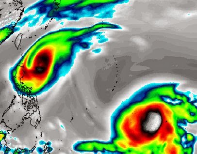
THIS FORECAST MAP SHOWS AN INFRA-RED SATELLITE IMAGE OF THE WESTERN PACIFIC ON MAY 9, 2015. TYPHOON NOUL IS LEAVING PHILIPPINES WATERS WHILE TYPHOON DOLPHIN IS GROWING STRONGER

The Western Pacific Ocean is in overdrive. Even as tropical storm Noul is strengthening into a typhoon and moving towards Philippines, another typhoon Dolphin is brewing in the same waters.

Let us talk about Noul first. The storm is about 100 miles east of Yap Island and moving WNW. It is strengthening all the time. Our very conservative estimates say the sustained winds in the storm are 75 kph. In the next four days it will ponderously move in the same (WNW) direction. By May 10 it will be a few hundred kilometers away from the Luzon coast. By then it will have intensified into a 140 kph storm.

According to the latest forecasts by the JTWC issued at 0900 hours GMT today the typhoon will be throwing out sustained winds of 115 knots by May 9. A super typhoon has winds of 130 knots. Inching close.

Our prediction is typhoon Noul will not make landfall into Luzon, Philippines but veer away sharply and move north on May 10-11. Even then the flail-clouds of the powerful storm will bring heavy rains to northern Philippines on these days.

Predicting even further, we believe typhoon will not hit Taiwan nor the Japanese mainland. We expect the storm will swing north-east and miss Japan. But this we cannot say with surety at this stage.

Now coming to typhoon Dolphin. It is presently an innocuous low pressure area bobbing in the Pacific Ocean. On May 7, 2015, it will start intensifying and turn into typhoon Dolphin. Dolphin will be even more powerful than Noul. But fortunately for Philippines it is expected to swing northwards on May 10 and miss hitting the country.

Our predictions at this stage are based on what reliable global forecast models say. Things can change as tropical cyclones are inherently fickle by nature. We shall keep you informed with latest updates and monitor any changes in the path of the two typhoons.

cyclone typhoon noul pacific philippines

Share this PostPin ThisShare on TumblrShare on Google PlusEmail This

Typhoon Noul: Threat To Philippines On May 10, 2015?

UPDATE, MAY 3, 2015

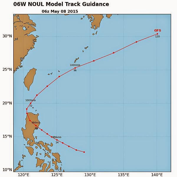
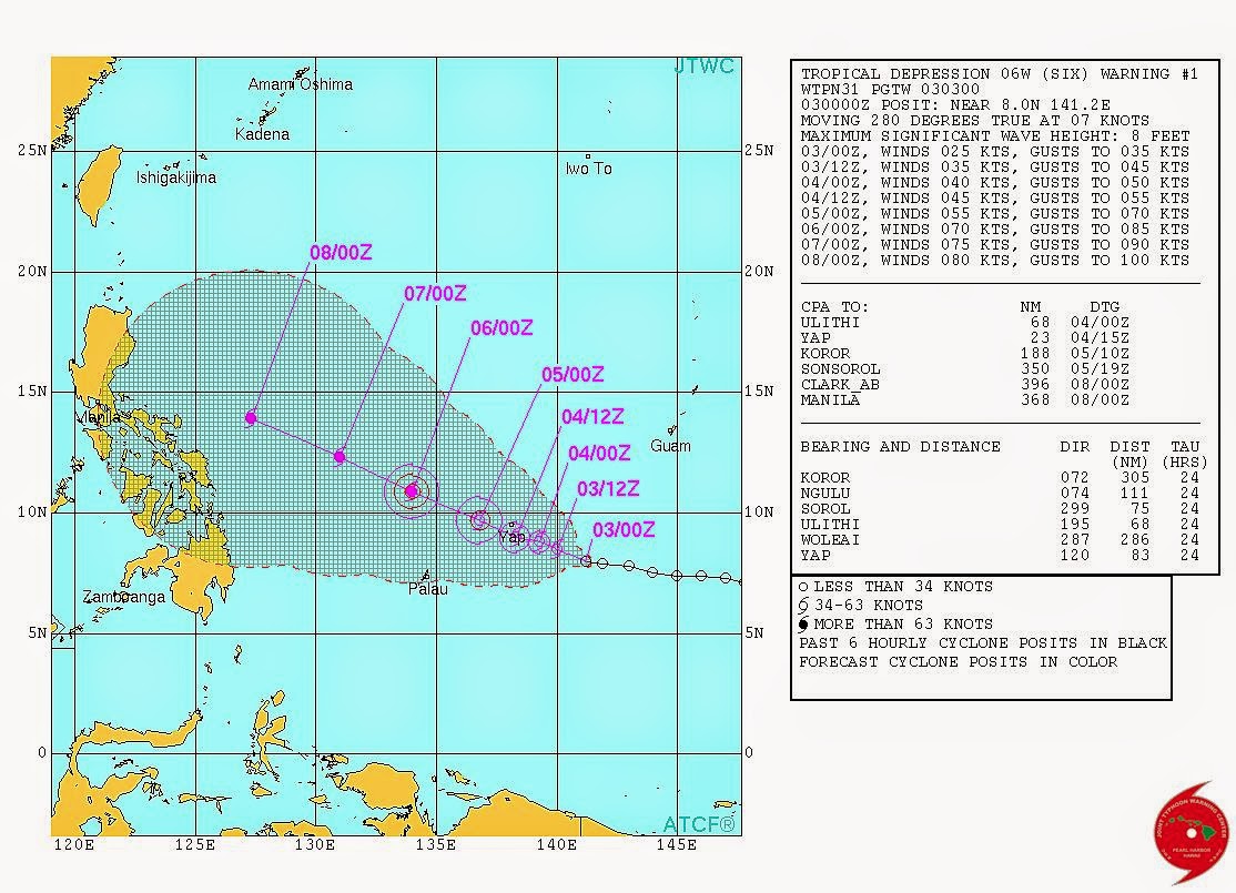
Future typhoon Noul has already formed. It is a tropical storm now. The Joint Typhoon Warning Center has named it "Six". And it has issued its track forecast. There is some disagreement amongst various forecast models as to whether Noul will hit Philippines or not. Hence the JTWC has remained non-committal on the subject.

Keep in touch for our updates.

typhoon Noul track JTWC
THE TRACK FORECAST FOR FUTURE TYPHOON NOUL BY JTWC. IT IS STILL UNCERTAIN WHETHER NOUL WILL HIT PHILIPPINES OR NOT.


-------------------------------------
Yesterday we had hinted at the possibility of a typhoon (Noul) forming in the Western Pacific in a few days. We had also said that the typhoon would move towards the Philippines but swing north towards Japan without hitting the country.

We are not so certain now.

It is certain that a typhoon is going to form in the Western Pacific in the coming days. It will start as a low pressure area that will crystallize in a couple of days around May 4, 2015, between Guam and Papua New Guinea, east of Palau. This low pressure will then slowly intensify into typhoon Noul and move towards Philippines

Will typhoon Noul hit Philippines?

Opinions differ between the two major forecast systems.

The American GFS says the tropical cyclone will head towards Luzon in northern Philippines but swing north on May 10, 2015.

The European Forecast Model predicts Philippines is in for a hit at Samar Island in eastern Visayas on May 9-10.

Typhoon Noul is going to be no Haiyan or Hagupit but it will be a considerable storm.

The Western Pacific typhoon season in 2015 got off with a rollicking start with super typhoon Maysak. Now Noul is coming. Hopefully not to Philippines.

See Typhoon Noul LIVE
Share this PostPin ThisShare on TumblrShare on Google PlusEmail This

Western Pacific Typhoon NOUL (2015) Imminent: Not To Affect Philippines

A typhoon is on the horizon in the Western Pacific in May 2015. Forecasts hint at the possibility of Typhoon Noul forming around May 8, 2015. These forecasts also say (At the present, at least) that the forthcoming storm will not hit Philippines but swing away towards Japan.

But at this juncture we cannot say this with emphasis. it is still a week before Typhoon Noul forms. Anything can happen after that. We can only hope the typhoon faithfully stick to the forecasts and not hit Philippines.

The picture will become clearer in the coming days. One thing is certain. A tropical storm is brewing in the West Pacific.
Share this PostPin ThisShare on TumblrShare on Google PlusEmail This

Tropical Cyclone QUANG To Make Landfall In Six Hours Into Western Australia

Tropical cyclone Quang is still a powerful storm with winds of 90 kph Just yesterday it was throwing out winds of 200+ kph. But it is weakening as it prepares to enter the Western Australian coast near Exmouth at 1200 hours GMT today.

Strong winds and torrential rainfall are pounding the area as the storm approaches. The airfield at Learmonth and the town of Exmouth are the most affected.

But as Quang makes landfall the winds will dramatically fall and it will turn into a depression and then a low pressure as it moves inland. It will dissipate rapidly.

TROPICAL CYCLONE QUANG WILL MAKE LANDFALL AND DISSIPATE RAPIDLY AFTER THAT. BUT EXPECT HEAVY RAINS IN THE AREA IN NEXT 24 HOURS

Share this PostPin ThisShare on TumblrShare on Google PlusEmail This

Latest Forecasts/Updates


Popular Posts

Search This Site