Little Tropical Storm "VANCE" Will Dissipate Just Before Landfall At Mexican Coast November 4, 2014


It will be a nasty little storm. Not one of the large diameter hurricane. But small, fast moving and nasty. We talk here of tropical storm Vance.

In the next few days it will intensify, go around in an arc and finall reach the Mexican coast on November 4th near Tepic. The storm will dissipate before it makes contact with land. That part of the country will receive rains [Durango and Tepic].

The coast north of Tepic will be very windy.

Vance will break up before it hits the coast on Nov. 4

Track of TC Vance according to the NHC
Share this PostPin ThisShare on TumblrShare on Google PlusEmail This

Typhoon NURI To Form Today: A Category 3 Hurricane


The birth of Typhoon Nuri took place just west of Guam. By today evening (UTC} it will be a typhoon.

The word "Nuri" in Malaysian means a type of parrot. Well this bird is going to chirp very loudly. The JTWC predicts Typhoon Nuri will be a Category 3 hurricane with winds of 200 Kph on November 3, 2014.

And Nuri is going to fly to Japan. It will kiss Japanese shores on November 7 and move along the east coast with strong gale and a deluge. Tokyo too will feel its effect.

The Philippines will remain untouched by the storm. In a day or two it will curve northwards towards Japan.

XWF WEATHER FORECAST MAP: November 6-7: Nuri about to kiss Japan

This is how Nuri will move along Japan: November 6-7


Share this PostPin ThisShare on TumblrShare on Google PlusEmail This

Bay of Bengal In Ferment: Depression [Or Cyclone Priya?] Will Move Into Tamil Nadu November 7

November 7. The system [Cyclone Ashobaa-Priya] about to hit Tamil Nadu

There is massive churning going on in the Bay of Bengal presently (The Northern Indian Ocean has been active this year: Nanauk, Hudhud, Nilofar and now Priya perhaps?]. It has brought heavy rains to Sri Lanka.

But it is going to throw up a deep depression [Or Cyclone] in the first week of November. The system will form off the Tamil Nadu coast and move into the state on November 7, 2014.

Present indications are its going to be a deep depression. But a little more intensification and Cyclone Priya [Ashobaa?] will form.

We will watch the sea closely in the next few days.


Share this PostPin ThisShare on TumblrShare on Google PlusEmail This

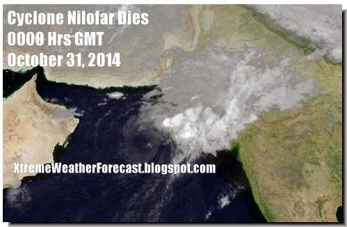
Last Update: End of Cyclone Nilofar at sea


The once powerful storm is no more. Nilofar died last night in the dark waters of the Arabian Sea. It is a depression now. It will disappear in a few hours.

The fears of the Sindh and Gujarat governments were unfounded after all. All Nilofar will offer is rough seas for 24 hours, a few showers in Sindh and some winds (a paltry 20-30 Kph off the coast of Sindh and Kachchh.

No heavy rains, no devastating winds. Nothing.

Nilofar may have died suddenly but two more storms are coming in the next 10 days. Cyclone Priya (Ashobaa?] may come calling to Tamil Nadu. Typhoon Nuri will head for Japanese shores.

Tropical Storm Vance is taking a stroll in the eastern Pacific before giving Mexico a visit.

Keep reading this site for the latest.
Share this PostPin ThisShare on TumblrShare on Google PlusEmail This

Cyclone NILOFAR Update: November 30, 2014, 0300 Hrs GMT: Cyclone Will Disintegrate Mid Sea By Tomorrow


Cyclone Nilofar will subside before making landfall.

The westerly winds will sound the death knell of Cyclone Nilofar. Presently it is about 700 kms from Naliya. It is quite strong now with 100 Kph to 125 Kph winds. But it is weakening rapidly by the hour. By Friday afternoon it will be history. Just a low pressure area that will bring some showers to Sindh in Pakistan and Kachchh (Also parts of Saurashtra} in India till Sunday (November 2, 2014].

Western Kachchh and Karachi will remain windy till Saturday along with some rainfall.

How much rain will Nilofar cause? From now till November 2, 2014

The 5:30 AM (IST] bulletin by the Indian Met.for #CycloneNilofar

The JTWC latest bulletin issued at 0300 Hrs, (GMT] October 30, 2014, says Nilofar will break up completely into low pressure area Saturday night before making landfall


Share this PostPin ThisShare on TumblrShare on Google PlusEmail This

Cyclone NILOFAR: How Will It Affect India and Pakistan?


Latest Infra-Red Satellite Image of Cyclone Nilofar : 1200 HRS GMT, October 29, 2014


The lady is in the Arabian Sea throwing out winds howling at 200-230 Kph. Cyclone Nilofar is slowly inching towards land. The lands affected will be India and Pakistan.

---------------------
LATEST UPDATE: The cyclone will start weakening from tomorrow (Thursday)
----------------------

The winds will be worst at the Kachchh and Sindh coast. The IMD says they will be 80-100 Kph. That is much better than 200 Kph. Look what Hudhud did to Vizag.

The winds will start from Thursday afternoon and continue till Saturday. Worst will be on Friday. Karachi is in for a battering with 100 Kph winds. Dwarka and Kachchh districts will get off with 60-80 Kph winds. But northern Kachchh (Koteshwar) will get a 100 Kph hammering.

The ports of Okha, Jamnagar (Bedi and Sikka), Navlakhi, Kandla, Mundra, Kandla will feel winds of 50-70 Kph on Friday

 Nilofar is going to bring rains. The heaviest will be in Sindh (Karachi included). Kachchh will get off with slightly less rain. Vagaries of nature!

Heaviest rains are expected in Sindh (SE parts, Karachi included). Flooding may occur.

In India rains are expected in Kachchh, west and north Rajasthan (heaviest around Bikaner and Jaisalmer). Showers expected even in Jaipur, Haryana and Delhi on November 1-2, 2014.

Rain Forecast Map: Cyclone Nilofar: From now till November 2, 2014


Total rainfall from Cyclone Nilofar: Where and how much?


Share this PostPin ThisShare on TumblrShare on Google PlusEmail This

Latest Update: Cyclone Nilofar: Is Strongest Now: Gusting At 230 Kph


Nilofar will make landfall here on November 1, 2014, early morning (IST)

Contrary to expectations, Cyclone Nilofar did not turn into a Category 4 Hurricane. It is at its strongest now. It is about 900 kms from Karachi and 400 SW of Masirah in Oman. It has average winds of about 195 Kph, gusting up to 230 Kph.

It has started curving now towards the Gujarat-Sindh border which it will hit on Saturday (November 1, 2014) early morning (IST and PST) at Koteshwar in Kachchh (India). It will hit land with winds of 80-90 Kph gusting up to 110 Kph. This what the JTWC predicts.

There is some disagreement between the JTWC and GFS about the cyclone.

GFS forecasts say Nilofar will hit Naliya (Gujarat) on Friday (October 31, 2014). That is a day earlier.

Either way, coastal Sindh is in for very strong winds and rains. As is northern Kachchh.

The rains will start from tomorrow (Thursday) afternoon and will increase all the time.

Flooding will happen in Sindh. Heavy rains expected in NW Rajasthan (Jaisalmer, Bikaner). The rains will reach Haryana and some showers in Delhi too.


Share this PostPin ThisShare on TumblrShare on Google PlusEmail This

NILOFAR UPDATE: 2:30 PM GMT Oct.28,2014: Cyclone Nilofar To Turn Into Category 4 Storm (Super Cyclone) Tomorrow


Nilofar is going to be bigger than expected. In an earlier update we had hinted at a Category 3 Hurricane. The lady is going to be a bigger killer than expected. A Category 4 storm.

Yes, come tomorrow morning and it will turn into a massive storm with winds of 230-280 Kph. We can safely call it a super cyclone. (The IMD says winds above 222 Kph makes a super cyclone). Thank God that it is not going to hit Oman!

That is what the JTWC says in its latest bulletin at 3 PM, GMT, October 28, 2014.

Though NOAA says it will be strongest with only 195 Kph winds by tomorrow evening. That would make it a Category 3 hurricane.

The update adds that it will weaken a lot before landfall at Narayan Sarovar in Kachchh (Gujarat) on Saturday afternoon (November 1, 2014). The winds will be about 75 Kph gusting up to 90 Kph

VIDEO: BIRTH OF A MONSTER: CYCLONE NILOFAR TODAY (OCTOBER 28, 2014)


Share this PostPin ThisShare on TumblrShare on Google PlusEmail This

Cyclone Nilofar Will Weaken Before Hitting Kachchh-Sindh: Strong Winds To Lash Oman Tomorrow

XWF-WEATHER FORECAST MAP: Cyclone Nilofar on Thursday evening. It will be at its strongest then. After that it will rapidly weaken before landfall

Nilofar cyclone may throw up awesome winds of 200-240 Kph tomorrow but by the time it makes landfall at Kachchh-Sindh it will weaken considerably.

Both the GFS forecast and JTWC forecast agree that the storm will weaken before landfall.

The GFS says landfall will be on October 31, 2014.

JTWC says it will be on November 1, 2014.

Both agree that at landfall winds will be about 65-90 Kph.

Nilofar will bring rains to Kachchh (Gujarat) and southern Sindh. Karachi is in for rains and winds of 80 Kph on October 31-November 1.

What about Oman? Cyclone Nilofar is not going to hit Oman. It will receive some rains and strong winds of 80-90 Kph tomorrow.
Share this PostPin ThisShare on TumblrShare on Google PlusEmail This

Nilofar Update: Tuesday: October 28, 2014: Cyclone Will Turn Into A Category 3 Storm Tomorrow


Cyclone Nilofar is a big storm. Make no mistake about it. No wonder the Gujarat government is on its toes. Tomorrow morning it will turn into a Category 3 hurricane with winds of 200 Kph gusting up to a massive 240 Kph.

Till Wednesday morning (GMT) it will move in a northerly direction. By the evening it will have started changing direction and making a curve towards Gujarat.

On November 1, 2014 (Saturday) it will make landfall at Narayan Sarovar in Kachchh, Gujarat. The winds then will be 85 Kph gusting up to 100 Kph. The JTWC forecast says Cyclone Nilofar will weaken by landfall. Small mercies for Gujarat.

But even winds of 80-100 Kph is nothing to sneeze at. Not to forget the torrential rainfall which will lash entire Kachchh for 24 hours.

The latest track path forecast for Cyclone NILOFAR according to the JTWC
Share this PostPin ThisShare on TumblrShare on Google PlusEmail This

Cyclone Nilofar Update: Target Dwarka (Gujarat) Friday October 31, 2014

Forecast map: Nilofar about to hit Gujarat. Late night October 30, 2014.

Cyclone Nilofar seems to have changed its mind. Earlier forecasts said it would embrace Karachi.
But latest forecasts show that it is going to curve more than expected. That means it will make landfall at holy Dwarka on Friday, October 31, 2014.

It will than move through the Gulf of Kachchh and affect Mandvi, Mundra,  Kandla before weakening and moving into parts of northwest Gujarat.

Nilofar (At least present trends say) is not going to be as strong as the recent powerful Hudhud. So it it will dissipate even as a rain-bearing system after moving through Gujarat.

Presently Cyclone Nilofar is intensifying and moving towards Oman. But it will change direction and start in a northerly trajectory, thus avoiding landfall into Oman.

It will weaken slightly as it moves north till October 29.

But on Wednesday it will start curving towards Gujarat and strengthen again.

Mercifully by the time it hits the Gujarat coast it will weaken to winds of 100-120 Kph.

In the next 24 hours it will be at its peak with winds howling at a frightening 200+ Kph. The eye will be clearly visible then.

Most of the rains will fall in Kachchh-Saurashtra. Pakistan will get some showers (Karachi) on October 31.

Oman will see strong winds, dark clouds in the coastal areas. And some showers in the next two days.
But it will be Saurashtra-Kachchh which will bear the brunt of Nilofar's fury.

There are 3-4 days before Cyclone Nilofar touches land. Till then Oman, Sindh and Gujarat will be on tenterhooks.

Nilofar is an unpredictable wild lass capable of anything.

In the next 4 days we will keep a keen watch on this beautiful but dangerous creation of Mother Earth.


Share this PostPin ThisShare on TumblrShare on Google PlusEmail This

Latest JTWC forecast: Nilofar Cyclone will hit Kachch Gujarat Friday morning


The JTWC in its latest bulletin (October 27, 2014, 8:30 AM IST) says Nilofar cyclone will enter Gujarat near Narayan Sarovar (Western Kutch) on early Friday (October 31, 2014) morning, Indian Standard Time.

There is some disagreement between this and what the GFS says. GFS says Nilofar will curve less and hit Sindh in Pakistan.

We will continue giving you the latest updates.
Share this PostPin ThisShare on TumblrShare on Google PlusEmail This

Cyclone Nilofar And Oman

Forecast Map: Nilofar reaches Oman coast: Late Tuesday

Cyclone Nilofar is 900 kms from Salalah (Oman). How is it going to affect Oman?

In the next two days the storm will move to the southern Oman coast.
Then just when it appears to us that is going to make landfall, Nilofar will move northwards along the Oman coast. It is going to skim along the entire coastline. Then on Friday. The storm will jerk away into a NE direction towards Pakistan coast.


The entire coastal areas of Oman will witness strong winds and heavy rains from Wednesday to Friday (October 28 to 30, 2014).

In other words, though officially Cyclone Nilofar will not hit Oman, it will feel its effects for two days.
Share this PostPin ThisShare on TumblrShare on Google PlusEmail This

Cyclone NILOFAR Will Hit Karachi October 30, 2014 Night


The latest (1500 hrs UTC October 26, 2014) JTWC prediction

Cyclone Nilofar is coming. Right now it is disorganized and hovering in the Arabian Sea east of Aden.

In the next few days it will strengthen and move towards Oman.

But it will just skim the Omani coast and abruptly change direction and hit the Pakistan coast at Karachi on Friday evening.

Nilofar about to make landfall at Sind. October 31,2014. Early morning

The mercy is that when cyclone Nilofar changes direction on October 29, it will weaken slightly. But even then it will hammer Karachi with 100+ Kph winds.

Very heavy rainfall is expected in Sind in October end.

The GFS forecast says the tropical cyclone will hit Karachi. The JTWC differs slightly. It says the target will be the Gujarat coast at Kutch.

We tend to go with the GFS forecast.
Karachi, watch out. Nilofar is not going to be soft, gentle and feminine.

Satellite image of Nilofar taken today (Sunday)


Share this PostPin ThisShare on TumblrShare on Google PlusEmail This

Hurricane GONZALO Is Battering Bermuda Now: May Reach Britain In A Few Days!


This guy may not be as big and powerful as Katrina but he has stamina. Hurricane Gonzalo which is hammering Bermuda now, may even reach the British Isles , according to the NHC!

That means this storm is going to make a trans-Atlantic trip. Very few storms have done that in recorded history.

The guy is pulverising Bermuda with 185 Kph winds. Newfoundland will get a taste of Gonzalo in a day or two with 100+ kph winds. When it reaches Britain on October 21, 2014, it will still pack winds of 60-115 Kph. Phew!

Hurricane Gonzalo reaches Britain on October 21, 2014


Hurricane Gonzalo Hits Bermuda. NBC Video
Share this PostPin ThisShare on TumblrShare on Google PlusEmail This

Gonzalo Is A Category 4 Storm Now: Will Weaken Soon: Bermuda Is In For A Hammering


Bermuda is in for a hiding from Hurricane Gonzalo. The battering will start from 3:00 PM (Local Time) in the afternoon. Heavy rains and winds that a Category 4 Hurricane can whip up.

Folks in mainland USA can rest easy. Gonzalo is not expected to make landfall anywhere. But expect some winds along the coast. In short the storm will prove a nuisance only for ships in the Atlantic Ocean, who are taking evasive action right now.

Newfoundland in Canada will have to be wary. A weakened Gonzalo is going to come calling on Saturday-Sunday night.

 October 18, 2014 night. Gonzalo about to Hit St. John's, Newfoundland, Canada

 This how the Canadians expect Gonzalo to move. Their prediction differs from the GFS which expects a direct hit on St. John's


The GFS expects a hit on St. John's on late night of October 18, 2014


Expected Path Track of Hurricane Gonzalo (Oct. 18 to Oct. 21)
Share this PostPin ThisShare on TumblrShare on Google PlusEmail This

Hurricane GONZALO Is Taking Birth Now In The Atlantic


XWF-WEATHER Forecast Map: Hurricane GONZALO about to slam into Newfoundland. October 18, 2014

The Western Pacific and Northern Indian Ocean have been active in the last few weeks throwing up tropical storms. Now it is the turn of the Atlantic Ocean.

Hurricane Gonzalo has already taken birth. As a low pressure are near Puerto Rico.

In the next week Gonzalo is going to gradually grow stronger and vicious. But folks in the US can rest easy. Gonzalo is not going to hit the US. It is going to cruise along the eastern coast (A good few hundred miles off) and grow stronger and hit Newfoundland, Canada on 18th October, 2014. (Local time)

The worst affected will be St. John's, Holyrood and Clarenville.

Present forecasts say by the time it slams into Canada it will be a beast of a storm.


SEE HURRICANE "GONZALO" LIVE BELOW (Courtesy: nullschool)
Share this PostPin ThisShare on TumblrShare on Google PlusEmail This

Tropical Storm ANA To Hit Hawaii Islands On Sunday, October 18, 2014 With 150 Kph Winds


XWF WEATHER Forecast Map: October 19, 2014: Tropical Storm "Ana" about to move into Hawaii

Cyclone Hudhud has devastated Eastern India. Typhoon Vongfong leaves Japanese shores. Now the action shifts further east. Tropical Storm Ana has taken birth in Northern Pacific Ocean. It is at presently throwing up winds of 65-85 Kph. It is presently 850 nautical miles East South East Of Hilo (Hawaii).

In the next few days it is slowly going to intensify further to speeds of 140-170 Kph. Our guess is when it hits Hawaii, it will be spewing a 150 Kph gale.

The JTWC believes that landfall will be later. Not October 18. But perhaps a day later. GFS forecasts say it will be on October 18, 2014 (Early Saturday night HST).

The weather for two-three days after that will be rough as Ana moves over the islands.

If you are thinking of a trip to the Hawaii around October 18-21, 2014, think again.

We will keep you posted.

UPDATE: TROPICAL STORM 'ANA' OCTOBER 15, 2014

TC Ana will pass by the main island on the 18th of October with 150-180 Kph winds. Ana is gonna be quite nasty


#TropicalStormAna forecast by KITV http://goo.gl/R9UzcI
Share this PostPin ThisShare on TumblrShare on Google PlusEmail This

NOAA Site: Cyclone Hudhud Had Winds of 215 Kph When It Hit Vizag On Sunday (October 12, 2014)

(Image Courtesy: Indian Express) Vizag airport after the storm

As we had feared in our earlier article (as the storm was approaching), Tropical Cyclone Hudhud has left a trail of devastation in Visakhapatnam, the Ground Zero.

There is a reason why statues have been toppled, cars hung from trees, and Vizag airport looks like a war zone. Contrary to what the IMD (And the Indian media) said the winds at landfall, at 11:30 AM on Black Sunday were not 180-190 Kph, but 215 Kph. The site of NOAA (National Oceanic and Atmospheric Administration) records the wind speed at 115 knots (About 213 Kph) at the time of landfall.

The Indian Navy had recorded wind speed at 200 Kph.

Some Indian media sites have patted IMD on the back and patted themselves on the back ("We Indians have got smarter") for the accurate prediction. (180-195Kph)

The JTWC (and our site) had repeatedly warned of winds of 200+ Kph (Gusting up to 250 Kph).

I guess the xenophobic "Us better than them" mentality persists in many Indian minds.

We do appreciate (In fact, Kudos) the constant updates the IMD was giving out prior to landfall of the storm, but in the end, the difference of an extra of 35 Kph made a lot of difference.
Share this PostPin ThisShare on TumblrShare on Google PlusEmail This

Latest Forecasts/Updates


Popular Posts

Search This Site