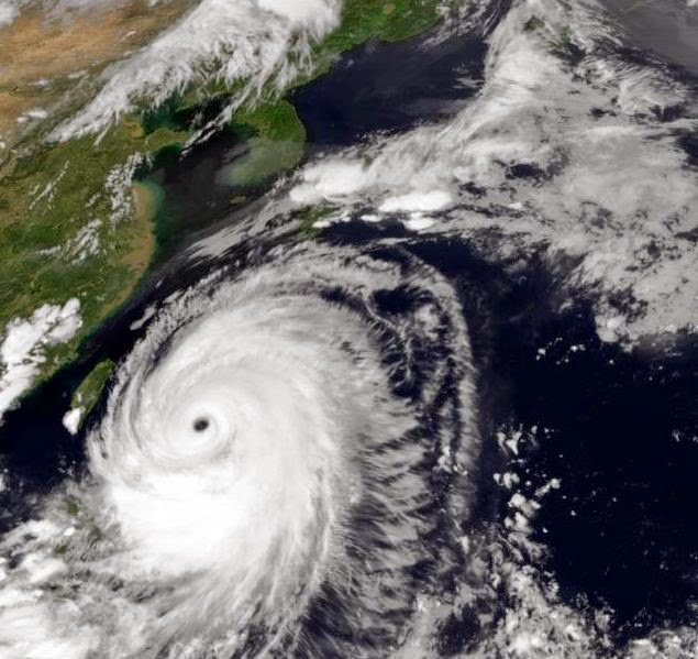
Satellite infra-red image of Neoguri taken today (July 9, 2014) at 3 AM GMT.
NEOGURI is no longer the monster it was a day ago. The weather front from China has steered it away towards Japan but also weakened it. But when it will hit Kyushu islands today (July 9, 2014) it will throw up winds of 150 kph. Not a sneeze that.
Neoguri is a slow moving storm. That is why it is dangerous. It might have weakened but it will move slowly over Japan, hence prolonging its destructive capabilities. It will hit Tokyo on the morning of July 11, 2014. So it will move over Japan for two days.
It reminds one of the destructive super cyclone that hit Orissa (India) in 1999. It had just hovered over the Orissa coast for a day or two. And battered it remorselessly. Cruel storms I call them. Who says nature is kind and gentle? Japan is luckier. Neoguri has weakened, the 1999 cyclone had lingered on as a super cyclone with winds of 300 kph. Phew!
But Neoguri seems to be weakening earlier than expected. It is yet to hit Kyushu islands and the winds have fallen to 90 kph. The storm is weakening fast.
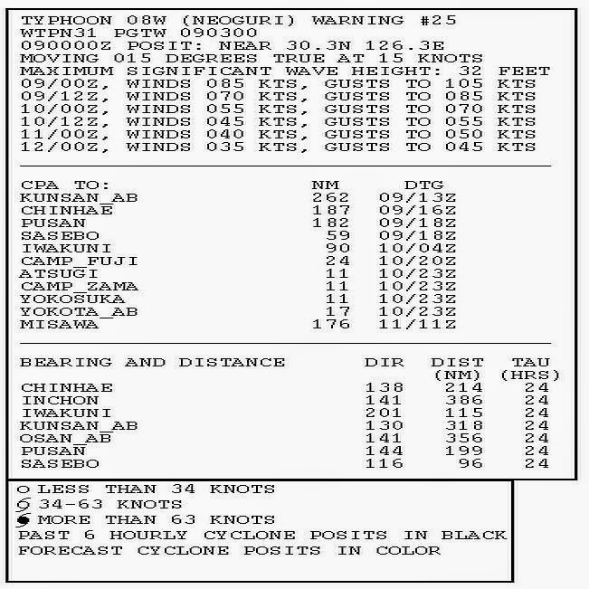
Latest JTWC bulletin says,
 TYPHOON 08W (NEOGURI), LOCATED APPROXIMATELY 242 NM SOUTHWEST OF
SASEBO, JAPAN, HAS TRACKED NORTH-NORTHEASTWARD AT 15 KNOTS OVER
THE PAST SIX HOURS. MAXIMUM SIGNIFICANT WAVE HEIGHT AT 090000Z IS 32
FEET.


This image was taken at 0225 hrs GMT today, July 9, 2014. The storm is weakening.
HISTORY
 THE TRACK HISTORY OF TYPHOON NEOGURI
HISTORY