Nanauk Was A Powerful Storm (Final Path Of Nanauk)


NASA  in its postmortem  of Cyclone Nanauk says it was a powerful cyclone throwing up storms 16 kms high in the atmosphere.

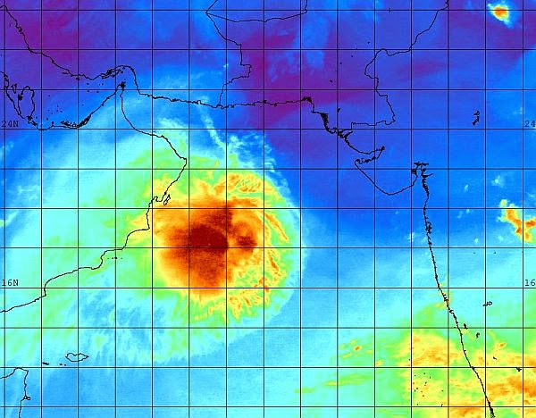
Tropical storm Nanauk formed west of India on June 10, 2014 and since then moved around towards the north west quadrant of the Arabian Sea. NASA and the Japan Aerospace Exploration Agency's Tropical Rainfall Measuring Mission's (TRMM) satellite found that Nanauk contained powerful storms dropping rain at a rate of over 247.3 mm/ 9.7 inches per hour when viewed on June 11, 2014 at 1549 UTC (11:49 a.m. EDT).

At NASA's Goddard Space Flight Center in Greenbelt, Maryland an analysis of rainfall from TRMM's Microwave Imager (TMI) and Precipitation Radar (PR) were overlaid on a 1530 UTC (11:30 a.m. EDT) enhanced infrared image from the European Space Agency's METEOSAT-7 satellite. TRMM PR data were used to create a 3-D view that showed that Nanauk contained powerful towering thunderstorms that were reaching heights of up to 16.8 km (10.4 miles). 


Friday the thirteenth proved unlucky for Nanauk as environmental conditions worsened and tore the storm apart. By 09:00 UTC (5 a.m. EDT), the Joint Typhoon Warning Center (JTWC) issued their final warning on the tropical cyclone. At that time, maximum sustained winds were near 35 knots (40 mph/65 kph) and weakening quickly. The storm's last official position was at 21.3 north latitude and 64.3 east longitude, about 285 nautical miles (328 miles/528 km) southwest of Karachi, Pakistan. At that time the dissipating storm was moving to the north at 9 knots (10 mph/~17 kph).

Source NASA

The path/track of cyclone Nanauk
Share this PostPin ThisShare on TumblrShare on Google PlusEmail This

Remains Of The Day: Image of the depression that remains of cyclone Nanauk

The remains of the once powerful cyclone Nanauk drifting in the Arabian Sea. Image taken 0000 hrs GMT, June 14, 2014, Saturday.
Share this PostPin ThisShare on TumblrShare on Google PlusEmail This

Nanauk's Graveyard: Two NASA Images Of North Arabian Sea


Share this PostPin ThisShare on TumblrShare on Google PlusEmail This

Indian Met. Dept. (IMD) Confirms Nanauk Is Breaking Up

The Indian Met. Dept. (IMD) in its 1430 hrs IST (0900 AM GMT) June 13, 2014 bulletin on cyclone Nanauk confirmed that the storm is disintegrating.

Nanauk is no more. The system is below cyclone strength, Just a depression.

We shall keep watching the storm for the next few hours to detect any signs of rejuvenation.


Share this PostPin ThisShare on TumblrShare on Google PlusEmail This

Cyclone Nanauk Is Breaking Up Fast! Will Disintegrate In 24 Hours!

Infra-red satellite image of Nanauk taken at 1000 hrs GMT today (June 13, 2014) shows the dying storm well

The JTWC says in its latest Cyclone Nanauk bulletin that the storm is dissipating rapidly. In 24 hours it will be below cyclone strength.

Here is what it says.....

130900Z (JUNE 13, 2014 0900 AM GMT) POSITION NEAR 21.4N 64.3E.
TROPICAL CYCLONE 02A (NANAUK), LOCATED APPROXIMATELY 258 NM
SOUTHWEST OF KARACHI, PAKISTAN, HAS TRACKED NORTHWARD AT 09 KNOTS
OVER THE PAST SIX HOURS.
   
MAX SUSTAINED WINDS NOW - 035 KT, GUSTS 045 KT

THIS IS THE FINAL WARNING ON THIS SYSTEM BY THE JOINT TYPHOON WRN CEN. THE SYSTEM WILL BE CLOSELY MONITORED FOR SIGNS OF REGENERATION.


Infra-Red Satellite Image of Nanauk at 1200 hrs GMT, June 13, 2014, Friday
Share this PostPin ThisShare on TumblrShare on Google PlusEmail This

Cyclone Nanauk Will Dissipate Mid Sea On June 16, 2014

It seems according to latest forecasts that Oman has been spared the fury of cyclone Oman. It is expected to disintegrate mid sea on June 16, 2014. It will be near the coat of Oman then. Position: 20.4 N, 61.2 E.


Latest Satellite image of cyclone Nanauk 01200 hrs GMT, June 13, 2014
Share this PostPin ThisShare on TumblrShare on Google PlusEmail This

Nanauk Will Not Reach Oman: Will Implode On June 15, 2014 Says JTWC

Even in the latest Nanauk cyclone bulletin (1500 hrs GMT , June 12, 2014)  the JTWC says it will not reach Oman but dissipate in the Arabian Sea itself on Sunday.

We have to see if this prognosis is supported by other forecast models. Off the hand, we feel this forecast will happen to be true.

Here is a gist of what the bulletin says in simple English.....

TROPICAL CYCLONE (TC) 02A (NANAUK), LOCATED APPROXIMATELY 425 NM SOUTHEAST OF MUSCAT, OMAN, HAS TRACKED WESTWARD AT 10 KNOTS OVER THE PAST SIX HOURS. 
............... WILL RESULT IN A RAPID WEAKENING TREND.
TC 02A IS FORECAST TO CONTINUE TRACKING WEST-NORTHWESTWARD OVER THE NEXT 36 HOURS. AFTERWARDS, THE WEAKENED TC IS EXPECTED TO SLOW DOWN AND DEFLECT POLEWARD BEFORE DISSIPATION..................

Satellite image of Nanauk taken at 1200 hrs GMT today (Friday, June 13, 2014)


Share this PostPin ThisShare on TumblrShare on Google PlusEmail This

GFS Says Nanauk Will Break Up Soon: Oman Cheated Of Expected Rains.

UPDATE JUNE 13, 2014 1000 HRS GMT

The latest GFS supports the JTWC forecast. Nanauk will dissipate mid sea near Oman coast in 24 hrs. So Oman will receive little or no rainfall. The remnants of the cyclone will start drifting in the sea away from Oman. 

So, no rains in Oman..

Water vapor satellite image of Nanauk taken at 1030 GMT, today, June 13, 2014 shows the storm is breaking apart.


Satellite image of Nanauk taken at 0900 hrs GMT Friday, June 13, 2014

Share this PostPin ThisShare on TumblrShare on Google PlusEmail This

JTWC LATEST FORECAST: 0900 HRS GMT, JUNE 12: Cyclone To Break Up Mid Sea On June 15: Won't Reach Oman

The JTWC in its latest forecast issued at 0900 hrs, June 12, 2014 (Today) has astounding news! Nanauk is not going to reach Oman. It will weaken in to a low pressure area on June 15, Sunday.

If this happens it is good news for India and Pakistan. A low pressure will bring a lot of rainfall in these areas (Provided of course if the remnants of the storm drift back. We shall have to analyse that later.)


PRESENT POSITION

120900Z (JUNE 12, 0900 HRS UTC) POSITION NEAR 18.3N 64.5E.
TROPICAL CYCLONE 02A (NANAUK), LOCATED APPROXIMATELY 359 NM EAST-
SOUTHEAST OF MASIRAH ISLAND, HAS TRACKED WEST-NORTHWESTWARD AT 07
KNOTS OVER THE PAST SIX HOURS.

Latest image of tropical storm Nanauk: Image taken at 0900 hrs, GMT, June 12, 2014
Share this PostPin ThisShare on TumblrShare on Google PlusEmail This

LATEST NANAUK CYCLONE SATELLITE IMAGES


IR Satellite image of the depression that remains of the once powerful cyclone Nanauk. Image taken 0000 Hrs GMT, June 14, 2014 (Saturday)

1200 GMT, Friday, June 13, 2014. Infra-red satellite image of a weakening cyclone Nanauk

This latest (1030 AM GMT, Today, June 13, 2014) water vapor satellite image of Nanauk shows that it is in its death throes


The Infra-red satellite image of Nanauk taken at 1000 hrs today (June 13, 2014) shows the storm is dying.


Satellite image of Nanauk taken at 0600 hrs GMT Friday, June 13, 2014


LATEST SATELLITE IMAGE: TAKEN AT 0300 HRS, GMT,  JUNE 13, 2014

Image taken at 0000 hrs, GMT June 13, 2014


Satellite image of Nanauk at 1200 hrs today (Thursday, June 12, 2014)

Infra-red image of Nanauk taken at 1200 hrs GMT June 12, 2014


Infra-red images of cyclone Nanauk taken at 1200 hrs GMT Today (June 12, 2014)

A NASA satellite of north Arabian Sea as Nanauk hovers around


Image taken at 0900 hrs , June 12, 2014 Today, Thursday

Cyclone Nanauk at 0600 hrs GMT June 12, 2014

Satellite image of cyclone Nanauk taken at 0600 hrs GMT, June 12, 2014, Thursday


Nanauk satellite image: June 12, 0600 Hrs UTC


Latest Nanauk Cyclone Image (June 12, 2014, 0630 hrs UTC


SATELLITE IMAGE OF NANAUK (3 AM GMT, JUNE 12, 2014)

NASA image Nanauk taken June 11, 2014 at 0830 hrs UTC
Share this PostPin ThisShare on TumblrShare on Google PlusEmail This

The ECMWF Model Says Nanauk will move north and weaken till it hits Pakistan

There is a great deal of uncertainty about the future of cyclone Nanauk.

The ECMWF model says the storm will start moving north towards Pakistan coast and start weakening. By the time it reaches Pakistan coast near Karachi it will be a low pressure area. So south coastal Pakistan can expect a deluge from Friday, June 13, 2014.


Share this PostPin ThisShare on TumblrShare on Google PlusEmail This

LATEST NANAUK TRACK/PATH FORECAST: It will break up near Oman

XWF WEATHER PREDICTION MAP: Latest GFS forecast says Nanauk will not make landfall into Oman but dissipate mid-sea on June 16 (See the map)

Latest GFS forecast says the cyclone Nanauk will break up near the coast of northern Oman.

It will keep going towards Oman. It will reach the seas near north Oman on June 13, Friday. After that it will NOT MAKE LANDFALL. It will hover around then strengthen and then start moving first north and then northeastwards. It will then start breaking up and completely disintegrate by Monday June 16, 2014.

AS WE SAID BEFORE NANAUK IS TURNING OUT TO BE A VERY VOLATILE AND UNPREDICTABLE STORM. SO WE CAN EXPECT ANYTHING IN THE NEXT 48 HOURS.
Share this PostPin ThisShare on TumblrShare on Google PlusEmail This

Latest JTWC Update Says Nanauk To Hit Oman June 16, 2014

The JTWC in its latest Nanauk Cyclone update (June 12, 3 AM GMT) says the storm will hit Oman a day late. On June 16 morning. It will the island of Masirah.

The BBC in a weather bulletin says that Nanauk is heading to Oman for now but we will keep a close eye on what happens next.

Our feeling exactly. Nanauk is a a very devious unpredictable storm. The ECMWF model says it will head towards Pakistan and break up before contact.

Let us wait and watch. Anything might happen.


Share this PostPin ThisShare on TumblrShare on Google PlusEmail This

Latest IMD Nanauk Bulletin: 0000 Hrs GMT, June 12, 2014


Share this PostPin ThisShare on TumblrShare on Google PlusEmail This

GFS Forecast Says Nanauk Will Hit Ash Sharqiyah Province On Sat. June 14, 2014

The GFS forecast is portraying a slightly different path/track for Nanauk. The JTWC says the storm will hit the Al Wusta province of Oman on June 15, Sunday. The GFS says it will make impact at the Ash Sharqiyah province on Saturday.

If this turns out to be true then Muscat will be affected more than expected earlier.

The GFS forecast says Ground Zero will be Ash Sharqiyah province of Oman on June 14, 2014
Share this PostPin ThisShare on TumblrShare on Google PlusEmail This

Latest Track/Path Prediction Map: JTWC June 11, 2014 2100 hrs GMT LATEST SATELLITE IMAGE

112100Z (JUNE 11 9 PM GMT) POSITION NEAR 17.6N 65.7E.
TROPICAL CYCLONE (TC) 02A (NANAUK), LOCATED APPROXIMATELY 439 NM 
EAST-SOUTHEAST OF MASIRAH ISLAND, HAS TRACKED WEST-NORTHWESTWARD AT 
02 KNOTS OVER THE PAST SIX HOURS.

The latest bulletin issued by the JTWC (2100 hrs GMT, June 11, 2014) says nothing much has changed. The cyclone is expected to be as strong as forecasted earlier. It will hit the Oman coast south of Khaluf on June 15, 2014, Sunday early morning. Winds then will be between 75 kph and 120 kph. Heavy rains and very high waves will lash the coast. Muscat is away from Ground Zero so it will not bear the brunt of the storm. But expect rains, and heavy winds from Saturday.


Latest satellite image of cyclone Nanauk (Image taken at 0000 hrs GMT, June 12, 2014
Share this PostPin ThisShare on TumblrShare on Google PlusEmail This

Latest Track/Path Prediction Map Of Nanauk Cyclonic Storm by JTWC

The latest track/predicted path pf Cyclone Nanauk by JTWC (Issued at 3 PM, June 11, 2014
Share this PostPin ThisShare on TumblrShare on Google PlusEmail This

Latest Satellite Image Cyclone Nanauk: 12 NOON GMT JUNE 11, 2014


The winds are gusting at 100 kph now (2 PM GMT, June 11, 2014). The IMD has warned that it is going to be very severe cyclonic storm with winds howling between 120 kph to 220 kph when Nanauk will be at its peak.

The IMD track/predicted path of Nanauk
Share this PostPin ThisShare on TumblrShare on Google PlusEmail This

Latest Satellite Image Of Cyclone Nanauk (June 11, 2014, 9 AM GMT)

This is the latest IR satellite image of cyclone Nanauk taken at 9 AM GMT Today, June 11, Wednesday, 2014. Looks like a monster.


Share this PostPin ThisShare on TumblrShare on Google PlusEmail This

Latest Prediction JTWC Path/Track Cyclone 02A (Nanauk)

The JTWC has issued its latest update on cyclone 02A presently hovering around in the Arabian Sea.

It says final destination is the same, Oman. Only the cyclone might hit a little later. Morning instead of early morning of June 15, Sunday, 2014. The predicted intensity is even more. Nanauk is going to be one big bad boy.

This bulletin issued at 9 AM, June 11 GMT, 2014.

By the way, the Indian Met. Dept. has finally given the name NANAUK to the cyclone! AT LAST!

Share this PostPin ThisShare on TumblrShare on Google PlusEmail This

Predicted Impact Of Nanauk Cyclone On Oman: Rainfall, Wind, Waves

The severe cyclonic storm Nanauk which is going to hit Oman on Saturday, June 14, 2014 is going to bring torrential rainfall and devastating winds to Oman. We give the forecast of the winds, waves and rainfall expected through XWF prediction maps.

Total accumulated rainfall in Oman till June 16, 2014 owing to cyclone Nanauk. The figures are in inches. It is going to be a deluge. Flooding.

Wind speeds in knots, Purple color is over 50 knots (93 kph). It is expected to be an awesome 150 kph. Destruction is feared.

Waves in meters. 6 to 8 meters high waves will batter coastal Oman. The island towns of Dawwah and Kalban will be worst hit
Share this PostPin ThisShare on TumblrShare on Google PlusEmail This

Latest Forecasts/Updates


Popular Posts

Search This Site