No Tropical Storm Likely In Arabian Sea In Next Few Days

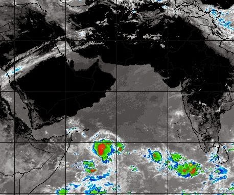
Latest satellite image of the Northern Indian Ocean (May 31, 2014, 1200 Hrs GMT)

After studying all the forecast models, one can say safely that there is little chance of a significant tropical storm developing in the Arabian Sea (Or Bay of Bengal for that matter) in the next few days.

We will keep a close watch on the seas and keep you updated. If any reliable forecast model indicates a coming storm we will let you know immediately. Early June is that time of the year (And September-November) when the Northern Indian Ocean comes up with some nasty storms.

The time period till June 20 is important as the seas are most trigger-happy. We will keep you posted.

The CPC (Climates Prediction Center) says "The expected evolution of the MJO (Madden-Julian Oscillation- technical stuff which we do need not bother about)) into early June tends to favor tropical cyclone activity in the Arabian Sea; however there is no model support for a TC and confidence is too low to be highlighted on the map" Simply put, it means there is a good chance of a tropical storm developing in the Arabian Sea in the first week of June, but no forecast model says so openly as the possibility percentage is low. But thing may change quickly.
Share this PostPin ThisShare on TumblrShare on Google PlusEmail This

Two Models Say: The Indian Ocean May Well Throw Up A Tropical Storm In First Week Of June

As we said earlier the southern Arabian Sea is in ferment. Two forecast models say the mass of clouds will throw up a tropical storm.

The CMC model says that a low pressure area will form in the southern Arabian Sea between the Horn Of Africa and Sri Lanka on June 1, 2014. This will then over the next few days intensify into a massive cyclone. It is expected to move in a WNW direction. It is the direction of northern Yemen-Southern Oman border. We have talked about the CMC forecast earlier.

The NAVGEM model says a low pressure area will form in the same area (8 Degrees North, 65 Degrees East) On June 2, 2014. What happens next? Latest (May 29, 2014, 1500 Hrs.) forecast from NAVGEM says it is going to be a full blown cyclone which may go anywhere. But it is generally agreed that the model is about 40% accurate. We will keep a close watch and keep you updated.

The god of all forecast models, the GFS, does not support these predictions. For now. Our hunch is the storm, weak or strong, will head towards the Gulf of Aden. Let us wait for further developments.

The big storm as predicted by the CMC Model on June 3, 2014. Seems to be a big storm.


The NAVGEM Model says it is going to be a full-blooded cyclone. Latest forecast map (May 29, 2014,  1500 Hrs.) shows the predicted position on June 5, 2014.

Satellite image of the Arabian Sea taken at 00.00 Hrs. GMT, May 30, 2014
Share this PostPin ThisShare on TumblrShare on Google PlusEmail This

Just One Point: Please Don't Question Our Integrity

Someone just wrote to us...."Kindly be accurate in giving out the information as this is a serious matter which needs to be addressed and prepared for. Just don't give the Prediction and projections unless it is positively CONFIRMED."

 We replied...."We know this is a serious matter. If one is looking for 100% confirmed forecasts, this is not possible in today's world even with the biggest supercomputers, as any meteorologist will tell you. If one is looking for greater accuracy, then wait for the weather bulletins by the country's Met office. What we do is give indications of a possibility of a tropical storm WELL IN ADVANCE. Sometimes we are proved wrong; Sometimes we are proved right. We are bloggers, not the country's official Met department. And our forecasts are based on real trusted forecast models, not our whims and fancies"
Link

Share this PostPin ThisShare on TumblrShare on Google PlusEmail This

ANOTHER FORECAST MODEL PREDICTS A CYCLONE IN THE ARABIAN SEA JUNE, 2014

What is interesting is that another forecast, this time by the Canadian Met. Department, predicts the development of a significant tropical storm in the same area in the Arabian Sea (8* North and 65* East). The cyclone is likely to form on June 1, 2014 and will be a significant tropical storm.

The latest image of the Arabian Sea by an US Navy satellite shows great ferment and churning

The area of the Arabian Sea between the Indian sub-continent and the Horn of Africa is presently seeing a lot of ferment. There is an unrest in the mass of clouds out there. And the conditions are ripe that they will throw out a big storm.

Let us wait for further developments.

Satellite Image Present Time: The arrow shows the restless mass of clouds that are likely to spawn a storm

The cyclone as predicted by Canadian Meteorological Department as seen on June 3, 2014.


Related:
Share this PostPin ThisShare on TumblrShare on Google PlusEmail This

No Oman Cyclone, Just A Low Pressure Area

FORECAST UPDATE MAY 28, 0850 HRS GMT

LATEST FORECAST UPDATES BY THE US NAVY MET. SITE SAY THERE IS NO CHANCE OF A CYCLONE IN THE ARABIAN SEA. IT WILL BE JUST A LOW PRESSURE AREA THAT WILL BRING RAINS TO YEMEN ON JUNE 4, 2014. OMAN WILL NOT RECEIVE ANY SIGNIFICANT RAINFALL.

No cyclone just a low pressure area that will bring some rains to Yemen on June 4, 2014

The US Navy Met. Site has in its latest forecast rules out the formation of a cyclone. According to its forecast it will be just a low pressure area.

A low pressure area will form in the area of the Arabian Sea with the location being 8 degrees North and 65 degrees East. This low pressure area will then drift west and bring rainfall to Yemen on June 4, 2014. Oman is not expected to receive any significant rainfall.

ALSO READ: Another Forecast Model Predicts Arabian Sea Cyclone On June 1,2014

Share this PostPin ThisShare on TumblrShare on Google PlusEmail This

The Cyclone Will Hit Southern Oman On June 4, 2014

The expected tropical storm touching the southern Oman coast on June 4, 2014

Latest forecast by US Navy Met. site says the tropical storm will hit the extreme southern coast of Oman on June 4, 2014, bordering the northern Yemen coast.

There is yet no confirmation of the expected storm from other forecasters.

PLEASE NOTE THAT THIS PREDICTION IS BASED ON FORECAST BY THE NAVGEM MODEL AND HAS NOT BEEN CONFIRMED BY OTHER FORECAST MODELS YET.

WE WILL KEEP YOU UPDATED.
Share this PostPin ThisShare on TumblrShare on Google PlusEmail This

US Navy Meteorologists Say Massive Cyclone Nanauk To Hit Oman On June 2, 2014

Cyclone Nanauk about to hit the south Oman coast on June 3, 2014

BREAKING FORECAST.......

THE US NAVY METEOROLOGISTS PREDICT A MONSTER CYCLONE(NANAUK) TO FORM IN THE ARABIAN SEA ON MAY 29, 2014 OFF THE KERALA COAST. IT WILL INTENSIFY INTO A MASSIVE CYCLONE AND HIT THE SOUTHERN OMAN COAST ON JUNE 3-4, 2014.

Globally there are only a handful of organisations that give out weather forecasts. The Americans do it, The British do it and the US Navy does it. The US navy has great interest in forecasting weather globally for obvious reasons.

These guys have their own forecast model called the NAVGEM (US NAVy Global Environmental Model).

And this model predicts that a low pressure area will form in the Arabian Sea around the Maldives on May 29, 2014. This will gradually gain strength and move northward initially. Then after a day or two it will start moving in a north west direction and hit the Oman coast on June 3-4, 2014, near the town of Mirbat, Fararah and Sawqirah.

UNDER IT'S INFLUENCE ENTIRE OMAN WILL START GETTING HEAVY RAINS FROM JUNE 1, 2014. THIS WILL CONTINUE FOR THE NEXT ONE WEEK. EARLY JUNE WILL SEE A FLOODED, VERY WET OMAN.

Heavy rains approach Oman on June 1, 2014

According to the forecast the storm (which will be christened "NANAUK") is going to be a big, mean, destructive storm.

I am waiting for confirmation of the forecast by other forecast models, including the venerable JTWC.

I will keep updating you.

For now it seems big bad NANAUK is coming Oman's way.

EXPECTED PATH OF CYCLONE NANAUK FROM MAY 30 TO JUNE 3, 2014

Latest Predicted Path Of The Storm
Share this PostPin ThisShare on TumblrShare on Google PlusEmail This

WE PREDICTED THAT.... Heavy rains lash ODISHA

We had foretold way back on May 11, 2014 that heavy rains would lash Odisha on May 26, 2014. It has happened. Here is a news item in the New Indian Express....

Heavy Rains Lash Odisha; Flood Alert in 6 Districts By Express News Service
Published: 26th May 2014 09:32 AM
Last Updated: 26th May 2014 09:32 AM


BHUBANESWAR: The Odisha Government issued heavy rain and flood alert for six coastal districts after the low pressure-induced showers lashed many parts of the State on Sunday. The Special Relief Commissioner’s (SRC) office asked Collectors of Balasore, Mayurbhanj, Bhadrak, Jajpur, Keonjhar and Dhenkanal to remain alert for flash flood. The alert came after the low pressure off north Andhra Pradesh and south Odisha coast triggered heavy rains across several coastal, central and western districts. Balasore received at least 100 mm rain since morning, while Bhubaneswar reported over 92 mm rain during the day. Cuttack (72 mm), Chandbali (53 mm), Puri (58 mm) and Gopalpur (54 mm) also received good showers. Other districts such as Angul (24 mm), Dhenkanal (47 mm) and Mayurbhanj (15 mm) as well as western districts, including Jharsuguda, also received showers.
-----------------------------------------
From Deccan Herald
Heavy rain brings respite from heat in Odisha 
Bhubaneswar, May 25, 2014

Heavy rain under the impact of a low pressure formed in the Bay of Bengal, lashed many parts of Odisha including Bhubaneswar on Sunday, bringing in the much-awaited relief to the people reeling under intense heat wave for the last several days. The rainfall will continue for the next two days.


Share this PostPin ThisShare on TumblrShare on Google PlusEmail This

Will the tropical storm in Bay Of Bengal Turn Into Cyclone NANAUK?


A low pressure area hovers in the seas off the coast of Burma. It is 370 nautical miles south of Chittagong presently.

The question is; will the low pressure area remain just that when it makes landfall? Or will it grow stronger into a depression; or may be a cyclone. May be NANAUK might form in the Bay of Bengal. We are keeping a close eye.


The JTWC (Joint Typhoon Warning Center), which is considered a god by storm trackers and predictors, says there is a 50-50 chance of a tropical storm developing.


The low pressure area is likely to intensify rapidly tomorrow into a tropical storm (May 24, 2014). Then it will move towards Bangladesh and then intensify rapidly again on Monday (May 26, 2014). 


Chances are, it is Nanauk in the making.... But will the storm gain enough strength to qualify in the eyes of IMD (Indian Met. Dept.) to be honored with a name; NANAUK?


UPDATE: MAY 24, 2014, O430 GMT

Present forecasts say the system will intensify in the next day or two and make landfall. Opinions vary. Orissa-West Bengal coast. Or Bangladesh. The tropical storm is unlikely to gain enough strength to be given a name, Nanauk. Certain forecasts say that it will not be a mere low pressure, but a deep depression. This system will be closely watched by us.


Share this PostPin ThisShare on TumblrShare on Google PlusEmail This

Expected Low Pressure Area in Bay of Bengal Will Drench Bengal Or Bangladesh?

A low pressure area is swirling in the Bay of Bengal off the Burmese coast. Where will it go?

Forecasts differ slightly. One says it is bam-bam-woosh for Bangladesh. Very heavy rains from Monday (May26, 2014). Others say the low pressure area will first affect coastal Orissa and West Bengal.And then it will move into Bangladesh two days later, that is on Wednesday (May 28, 2014).

But expect heavy rains all the same. Question is, will it be West Bengal first. Or Bangladesh and then Assam, with West Bengal escaping with comparatively less precipitation.

 Alternative 1: The system hits Bangladesh on May 26, 2014  and then moves over into Indian NE

Alternative 2: Drenches Orisaa, West Bengal on May 26, 2014. And then moves into Bangladesh on May 28 (Wednesday).

(Will it turn into Cyclone NANAUK?)
Share this PostPin ThisShare on TumblrShare on Google PlusEmail This

Bangladesh, Indian NE in for a deluge on May 26-27, 2014

May 24, 2014. The massive rain-bearing low pressure as it heads into Bangladesh. Maximum rainfall will be on May 26-27, 2014.

Bangladesh is in for a real pounding by the rains gods. A low pressure area will form within a day or two off the coast of Myanmar. This system will then move north straight into Bangladesh. Thou the rains will start from Sunday (May 25, 2014), the heaviest lashing will occur on Tuesday (May 27, 2014.

The Indian NE states too will receive heavy rains as the system will move there from Bangladesh.

Chances of flooding, folks. As the precipitation will be a deluge, no less.


Share this PostPin ThisShare on TumblrShare on Google PlusEmail This

CYCLONE NANAUK IS COMING! To Hit Oman, Pakistan or Gujarat Around June 5-6, 2014?

LATEST UPDATE MAY 27, 2014

US Navy Weather Experts Say A Massive Tropical Storm Will Hit Central Oman On June 2, 2014. 
Cyclone Nanauk as seen On June 4, 2014

The North Indian Ocean is infamous for throwing up awful tropical storms in June (and also September-October) every year. It is not going to disappoint us this year too. 

Cyclone NANAUK is coming! It is the Arabian Sea who is going to mother the storm. Latest forecasts say that the storm is going to take birth off the coast of Cochin on May 31, 2014. It will start as a low pressure area (as all storms do) and then start gaining strength and move out in the Arabian Sea in a North-Westerly direction initially.

That is the general direction towards Oman. But after a couple of days it will start veering away from Oman and start moving in a northerly direction. So it is to be seen where Cyclone NANAUK will hit. Pakistan or the Indian state of Gujarat?

It is early days. It might hit Oman.

Let us wait and watch.

Forecast Map: Animated path of expected cyclone Nanauk from May 31, 2014 to June 4, 2014

LATEST UPDATE MAY 27, 2014


US Navy Weather Experts Say A Massive Tropical Storm Will Hit Central Oman On June 2, 2014. 

Share this PostPin ThisShare on TumblrShare on Google PlusEmail This

Weather Gods Change Mind Again: Now Deluge In West Bengal, Bangladesh On May 29, 2014

It is rightly said that it is difficult to fathom the weather gods. Especially when we are looking at a 15 days forecast. We have said earlier that heavy rains were likely in Orissa-Andhra and then Assam around the 26th of May, 2014.

Well the rains have changed dates and place again. Now forecasts say there is going to be deluge in West Bengal on May 28-29, 2014. Parts of Bangladesh too will be affected.

This is a nasty rain forecast map. It shows the forthcoming deluge in West Bengal, Bangladesh and Assam on May 28, 2014
Share this PostPin ThisShare on TumblrShare on Google PlusEmail This

Heavy Rains To Lash Assam, NE India From May 22, 2014. Floods Likely


Heavy rains will start in Assam from May 22, 2014

Latest forecasts indicate that Assam is heading for floods by the end of the
month. We have predicted rains in West Bengal, Orissa and Andhra coast earlier around May 26th. But latest trends show that Assam will bear the brunt of the rain fury. The precipitation will start from May 22, 2014 and will turn heavier by May 27. The Indian North East is in for very heavy rains around May 27, 2014. 

 Danger of flooding in these areas.
Share this PostPin ThisShare on TumblrShare on Google PlusEmail This

Heavy Rains Likely In Orissa-Andhra Coastal Areas On May 26, 2014.

Heavy rains will lash Orissa-Andhra coast on May 26, 2014

El-Nino withstanding, the monsoons will be moving towards the Indian sub-continent soon. Satellite images show the Bay of Bengal is laden with moisture. The real action will start on the 18th of May when a large mass of rain clouds will form in the Andaman Sea off the Phuket coast.

This mass of clouds will move gradually north and drench the coastal areas of Myanmar for the next two days. EXPECT FLOODING IN COASTAL MYANMAR ON MAY 22-23.

These rain clouds will then drift towards the Indian coast. One can expect rains in West Bengal coast from May 24, 2014. But the brunt of the deluge will happen on the Orissa-Andhra coast on May 26. The areas affected will be the stretch between Visakhapatnam and Cuttack.

Share this PostPin ThisShare on TumblrShare on Google PlusEmail This

Latest Forecasts/Updates


Popular Posts

Search This Site