CYCLONE WARNING FOR IMMINENT ARABIAN SEA TROPICAL STORM
LATEST CYCLONE UPDATE: 1230 HRS GMT JUNE 7, 2014
Cyclone Nanauk is coming. No doubt about that. The present low pressure in SW Arabian Sea will move in a NE direction and strengthen into tropical cyclone NANAUK on June 9, 2014. Monday. That is day after tomorrow.
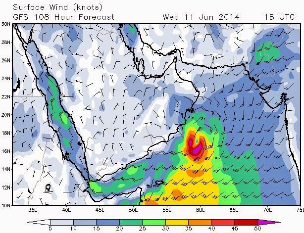
Then it will move in a NW direction , then in a westerly direction. It will hit the central Oman coast on June 11, 2014. Wednesday.
We had said in an earlier update that the expected storm would be weak. But after studying latest GFS model forecasts we have to change our advisory.
IT IS GOING TO BE QUITE A BIG STORM. PREDICTED WIND SPEEDS ON THE BEAUFORT SCALE ARE BETWEEN 9 AND 10. THAT MEANS BETWEEN 75 KPH AND 100 KPH. WHEN IT HITS THE OMAN COAST WINDS WILL GUST UP TO 75 KPH.
The storm will create waves between 3 metres to 8 metres on the coast of Oman.

Satellite image of the Arabian Sea taken today by INSAT 3D (Courtesy IMD) at 1530 hrs GMT (1900 hrs IST)


1 comment:
WTH?
GFS is not an accurate predection system, plus how could you define a track and IMD did not even show any concern to thar low pressure area.. when you predict some thing give us facts, and reasons for what is going to happen..never bluff!
Post a Comment