 |
| Weather Prediction map. October 30, 2012. Wind speed map. Red color is real bad news. Winds excess of 70 Kmph |
It is October and time for the North Indian Ocean to churn up big destructive tropical cyclones. Well, this year is going to be no different. The Arabian Sea is going to spawn a low pressure area but it will move towards the Horn of Africa skipping its usual haunts, Gujarat and Oman.
But the main prediction is the big bad storm that the Bay of Bengal is going to engender. The birth place of the cyclone is going to be east of the Andaman and Nicobar Islands.On the 26th of October, 2012.
 |
| Rain prediction amp. October 27, 2012. Andaman, Nicobar Islands getting a drenching. Color pink means deluge. |
After drenching the Andaman islands on the 27th the storm will rapidly gain strength and move north-westwards and reach the coast on the Orissa-Andhra Pradesh border on October 30, 2012.
Prediction now say it will then start losing steam and start moving along the coast in a north-easterly direction and make landfall on the Bangladesh-North East Indian border on October 31, 2012.
The places to get a real drenching? Andaman and Nicobar Islands, Northern Andhra Pradesh coastal areas, Orissa, Bangladesh coast and India's north-eastern states of Manipur, Mizoram, Tripura and parts of Assam. West Bengal, Bangladesh and the north eastern Indian states mentioned will receive rainfall till the 2nd of November.
 |
| Rain prediction map. October 31, 2012. The storm moves to make landfall. Light blue color means heavy rains |
Also we are now saying that the storm will weaken before it makes landfall. This too is hard to say with conviction.
One thing is certain. A big cyclone is going to form in the Bay of Bengal in the next ten days. The governments of India and Bangladesh will have to watch the seas closely in the next few days.
 |
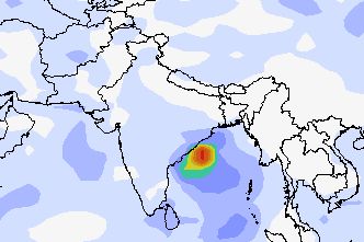
| Rain prediction map. October 30, 2012. The storm drenching coastal Andhra Pradesh and Orissa. |
Latest forecasts say that the storm is going to hit the Orissa coast on the 29th of October, 2012. It will them move into West Bengal and traverse the state moving northwards.Heavy rains throughout West Bengal (October 30, 2012), North Bengal, Sikkim and eastern Nepal on the 31st October, 2012. Orissa coast is in for strong gale and heavy downpour on the 29th of October.
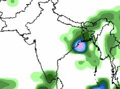 |
| Rain prediction map. Oct. 29 to Oct. 31, 2012. Cyclone Murjan |


1 comment:
what you think about arabian sea ?
Post a Comment